


 English (pdf)
 Article in xml format
 Article references
 Send this article by e-mail
 Cited by SciELO
  Cited by Google
  Similars in
SciELO
Similars in
SciELO  Similars in Google
 Permalink
Introduction
Colombia has been tackling the challenge of reducing the effects of drug trafficking, such as the growth of illicit crops 1. The Colombian government has been implementing, for the last decades, several measures to confront this problem like forced eradication, security forces operations to destroy facilities of illegal groups, and programs to substitute the crops 2-4. However, the project Integrated System for Monitoring Illicit Crop (SIMIC for its acronym in Spanish) of the United Nations Office on Drugs and Crime (UNODC) has recently reported historic levels of illicit crops in Colombia, i.e., 204.000 Ha 5. This shows that despite the measures taken by the government, illicit crops are still a major issue that requires more developments to support the Colombian authorities to confront it 6. In this context, some first steps have been taken including development programs to identify the areas of the crops. For instance, the SIMIC project, which has been developed since 1999 using LANDSAT ASTER and SPOT satellite images and aerial photographs. From those images, control points, terrain coordinates, and image processing software are used to process the information on crops in Colombia. Likewise, the use of satellite technology is also immersed in the platform of the Integrated Information and Monitoring System of Antinarcotics SIIMA 7, whose main objective is to collect, interpret, process, and produce geographic services and images. This information can be used for decision-making in the strategic and operational environment for the control of antinarcotics, mining, and environmental violations.
Although these systems provide valuable information to get an excellent perspective of the situation of the illicit crops in the country, the security forces require customizable tools that allow them to manage their tasks associated with the eradication process. Currently, the commanders of the units manually prepare reports of patrol reports, destruction, or first responder, among others, which are commonly sent via radio communication. This information should be digitalized and adequately recorded to provide more reliable data to authorities.
Recently, in the academy, some approaches have arisen to provide solutions to support the tasks of the security forces. For example, Castiblanco and Castiblanco, 2018 8, proposed a customized geographic information system (GIS) to include information about a local community in Colombia to allow for better decision-making, such as specific conditions and needs of the inhabitants. Given that localization is a basic aspect of these kinds of approaches,some studies proposed methods to increase the accuracy of the location’s crops by using remote sensing and improving image processing 9,10,11.
Despite the promising results of reported studies, shortcomings still need to be addressed. For instance, manual reports may contain human errors since they are collected mainly by handwriting, which may lead to lost information or subjective interpretation. The elaboration of these reports can be more challenging, considering that manual eradication is a tedious and hazardous activity that may involve unexpected events. Namely, this activity could not be properly conducted due to related war events like sudden attacks by illegal groups. On the other hand, the accuracy of image-based systems can be diminished due to obstructions in harsh areas. In order to overcome the limitations of image-based approaches, some authors proposed the use of drones to access cloudy areas 11,12, nevertheless, such approaches do not address the issues related to jungle or rural areas with high constraints. Moreover, drones and other unmanned aerial vehicles have characteristics 13 that limit their access to areas where only the security forces can enter, which makes their use impractical for the areas where illicit crops may be located.
Considering the aforementioned and the few references found, this paper describes a mobile application aimed to support mobile patrols responsible for eradicating illicit crops in their areas of operations. The app is conceived to capture and send reports with georeferenced data of the eradication process to be accessed by commanders or authorized personnel. This is also aimed to support activities like monitoring the state of the crops or the terrains, which may be of interest to environmental or agriculture institutions, for example 14,15.
Methodology
To identify the essential needs in the field in order to be able to propose a suitable solution, first, we establish the primary factors and tasks involved in an eradication process. To this end, experts in the area were consulted, which has allowed us to identify the following main aspects of the process:
The crop is characterized by the type of plantation, the place of sowing, the form of sowing, and production time, among others. Particularly, the type of sowing is a crucial factor in deciding whether to conduct a forced or voluntary eradication. Specifically, sowing is classified as non-technified and industrialized. In the former, plants grow naturally, i.e., scattered growing in the terrains. By contrast, the latter presents specific planting patterns based on the land’s topography, the irrigation system, greenhouses, and the distances between bushes and furrows. In this case, forced eradication must be conducted by mobile patrols.
A photographic record must be carried out during the whole process, i.e., before, during, and after the eradication process. Before the eradication starts, it is mandatory to take two photographs of the crop to determine its prior stage. During the eradication, a photograph must be taken to record the state of the complete plants. Lastly, when the eradication is finished, three photographs must be taken to evidence the final conditions of the area eradicated.
Reporting data that identifies the unit and the operational situation. This will make it possible to keep a record of who, when, and where the information is taken in the field. This information can include: the date, the name of the tactical and operational unit, the number of troops in the eradication unit, the type of eradication, the campaign plan, and whether there is the presence of illegal armed groups.
User roles were identified in an eradication process’s reporting chain to be recorded in a software solution. They are differentiated by the type of credentials to access, e.g., commanders and information administrators have access to the reports of several areas of the country. In contrast, the eradicators have access exclusively to the reports they generate. The eradicators are responsible for collecting and reporting information on a specific eradication process in the field; this work aims to support this user.
When the eradication process is finished, all the areas should be georeferenced with a precision of 2-5 meters. This geo-positioning is associated with the information collected in the previous items.
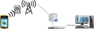
Considering these components, it was established that it is necessary to have a solution that involves all the stakeholders. Thus, we have conceived a georeferenced management software-based solution named SIREG, for its acronym in Spanish. This solution comprises information management, data collection, and reporting phases, as is shown in Figure 1. Its communication configuration was inspired by the work of Perez Corredor, 2013 16. Here, we only focus on a solution to support the tasks of the eradicators in the field, i.e., the data collection and reporting phases. Accordingly, we propose a SIREG mobile application for the eradicators as a first step toward optimizing the reporting and monitoring of the eradication process. In this context, the eradicator can send the information under two scenarios. In this first scenario, the application can be part of a complete solution, as is shown in Figure 2, in which the information can be sent through a secure network managed by the army authorities. The second scenario allows the application to send encrypted data through a traditional mobile network to management software.
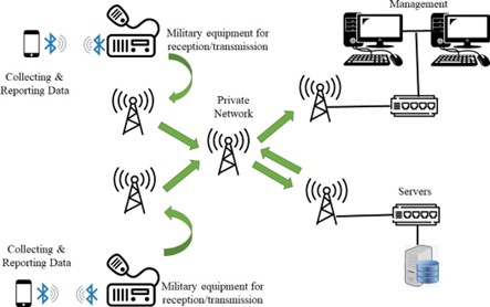
Source: authors
Figure 2 Second scenario in which encrypted data are sent through a public mobile network.
Taking the challenging conditions into account, the device selected was a Trimble TDC100, which is a robust Android mobile device designed to work in harsh environments that can collect georeferenced data with a positioning accuracy of 1m-2m.
Moreover, based on the components identified, in our approach, we considered three main factors: 1) security, 2) data reporting, and 3) data georeferentiation.
Security
The AES (Advance Encryption Standard) encryption technique was implemented, which is not vulnerable to linear and differential cryptanalysis. In order to counteract possible cybernetic attacks, a masking of the data was carried out at the programming logic level by customizing structures.
Data reporting
This component allows the user to fill out a form according to the crop’s characteristics, including the crop type, the number of plants in the case of a seedbed, the type of planting, the distance between rows, the distance between plants, plant height, legal crop association, among others. In addition, the user can indicate whether there is an associated housing, infrastructure, eradication technique, and information related to the military management.
Georeferentiation
The user can walk around the perimeter of the eradicated and collect the location data up to 60 points using the TRIMBLE TDC-100. Those points are used to draw the polygon representing the eradicated area, as illustrated in Figure 3.
Source: authors
Figure 3 Illustration of a polygon based on georeferenced points collected with the mobile device Trimble TDC-100.
As a result, the main functionalities of the SIREG mobile application are defined as illustrated in the diagram presented in figure 4, i.e., user data register, features of the crops, photographic recording and georeferencing data of the crop. These functionalities are described in major detail in the Results section.

Results
This section presents the first version of the mobile app and the preliminary results of the georeferenced process. As mentioned, the eradicators are responsible for managing the information in the field; therefore, they must enter it into the mobile app. Accordingly, we have developed for this user an interface whose functionalities are based on the components identified in the eradication process. Specifically, the main functionalities were established: user registration and login, crop characterization, photographic record, reporting data, and georeferentiation.
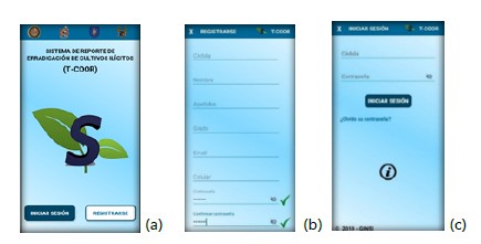
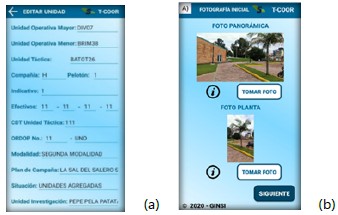
At first, the user will find the menu to register or login into the app to then find the initial configuration module. In this module, the user can modify her or his personal data, as well as must fulfill data relevant to the military domain, such as the units in charge of the operation, the mode of eradication, the operational situation, and related data to the illegal structures present in the area (see Figure 5). Next, the user can proceed with the initial photographic record (see Figure 6).
Source: authors
Figure 5 (a)Application initial screen; (b)The registration must be conducted to use the application; (c)The login screen is for registered users in the application.
Source: authors
Figure 6 (a)Screen of the information of the patrols; (b)Screen for the initial photograph record.
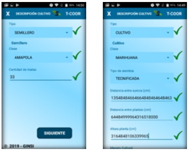
Following the methodology, in the next step, the user must describe all aspects of the crop description. To this end, the crop function allows to store the information mentioned in the methodology, e.g., the type of planting (see Figure 7). This is essential information for future eradication and control plans for the intervened areas. In this process, the user also must include a photographic record.
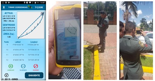
Once the eradication has been completed, the final photograph record must be conducted to proceed with the area’s georeferentiation. To do this, the user can open the menu to take the coordinates of the area, which uses the global positioning system sensor (GPS) incorporated in the Trimble. As shown in Figure 8a, the app not only presents the latitude and the longitude but draws the area as the points are measured; the user can take up to 60 points to represent the area. More specifically, the app shows the number of hectares and the centroid of the perimeter in coordinates while drawing the terrain according to the collected data. It is worth pointing out that the app allows for obtaining the number of hectares of the area, which is essential data for statistics and decision-making stakeholders in this field. In addition, if errors are identified during the data collection, the user can restart the data acquisition in the application.
Source: authors
Figure 8 (a) Screen of the georeferencing module; (b) An user testing using the mobile application.
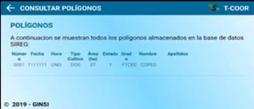
Furthermore, there is a module aimed to summarize the information in which the user can find the list of the intervened areas and all their associated data. This can be utilized to generated history reports with the georeferenced data which can be downloaded in a compressed format to a computer to be used in the elaboration of the follow-up for decision making (see Figure 9).
Regarding the evaluation of thegeoreferentiation, the temporal and localization accuracy were considered. First, the functionality of the app regarding temporal accuracy was tested. Namely, temporal accuracy refers to the date and time to which the dataset corresponds. The capture system was synchronized with the time and date presented by the Trimble device when the data were collected. When the device detects a network connection, after the capture of the information, the metadata cannot be modified by the user, i.e., the time of the data collection remains.
In respect of localization, preliminary tests were conducted in the Military School of Cadets “General José María Córdova” (Escuela Militar de Cadetes “General José María Córdova,” ESMIC for its acronym in Spanish). Specifically, the Trimble device collected the longitude and the latitude of several points while the user walked in the ESMIC. These points correspond to well-determined coordinates on Google Earth to establish the device’s performance. At the same time, the app recorded and stored each point’s coordinates. As shown in Figure 8(a), these are presented as a list of points (punto in Spanish) and used to draw the polygon of the area.
The measurement error was evaluated considering the sampling period to assess the influence of this variable in the position obtained to georeference the eradication area. Considering the Trimble technical characteristics, three sampling periods were chosen: 500 milliseconds (ms), 1000 ms, and 2000 ms. As a result, very low errors were obtained with values equal to 0.292%, 0.142%, and 0.168%, respectively.
Furthermore, the data collected can be downloaded in a KML file for further analysis and visualize relevant information, such as the number of hectares or other associated information with the eradication.
Discussion
We have described the development and implementation of an Android mobile application aimed to capture and send collected information, in a transparent manner, on illicit crops in the field. More specifically, the app aims to facilitate the work of the eradicators by eliminating traditional processes that involve voice data transmission, which can fail. These may also include handwriting and paper, which can be damaged in the area, require good writing by the eradicator, and can be more exposed to contain erroneous information.
In this regard, the app fulfills the need of administrators who require clarity and non-ambiguous information to be stored and used posteriorly in management software as shown in Figure 1. This functionality may vary to other approaches mostly focused on detected the illicit crops, in other words, they are not designed to support stakeholders in the field 17. Specifically, the app allows the collection of relevant information identified in the methodology, including the state of the eradicated areas and the type of crops, among others. This information can be used by the management software to obtain specific statistics such as hectares per region, type of plants or type of crops per region, and patrols involved in the eradication process per region, among others; accordingly, this permits traceability in the information or optimizing the process.
The photographic record associated with a location is an important feature of the app that presents advantages such as allowing users to access these records anytime. Likewise, this recording provides objective information on the evidence of the eradicators’ work.
Preliminary results of the georeferenced process indicate a good performance regardless of the sampling period, given that the errors obtained were below 0.3%. Furthermore, the system can alert the user about the precision when this may be greater than 2 m. This allows the eradicator to decide if to take the measurements or wait until better precision can be obtained. Considering this, the system presents promising results that can satisfy the data collection in the field while, at the same time, it opens new avenues to conduct further research to increase the positioning accuracy by implementing novel positioning algorithms.
By contrast, some shortcomings were identified in the developing process. For instance, given that the date and time are crucial to recording the activities conducted by the eradicators, changes in these items should be blocked to unauthorized individuals in the device. This restriction should be included in future versions of the app. In addition, the camera of the Trimble has a resolution of 800 x 600 pixels, which can require considerable memory resources and should be considered for future improvements. In this regard, this work opens the possibility of future analysis associated with the speed of transmission of information through field tests in different operational environments. This, in turn, is the starting point for developing research work aimed at sending eradication data in real-time when there is no internet connectivity in the areas of operations.
Importantly, the captured and stored information by the app could be extended to other associated issues requiring geo-referenced data from the area to be intervened, such as illegal mining and deforestation. These threats are also a priority for the government since these illicit activities are one of the main factors that affect the country’s natural resources 18.
The app has some limitations. For instance, despite that the app’s functionalities were designed according to the army’s personnel recommendation, it is required a study of user acceptance and its impact in the eradication process. In addition, more field tests are required to evaluate the geopositioning availability in extreme conditions and the evaluation of the integration of more functionalities that were not considered in this work such as memory management or user assistance.
Conclusions
In this paper, we present a mobile application to support the work conducted by military personnel to eradicate illicit crops. The app contains several functionalities required in the field that allows capturing and reporting information collected by the eradicators. The generated reports comprise photographic recordings, features of the crops, georeferenced eradicated areas, and relevant information for military management. The app was implemented in a mobile Trimble, which shows good performance with errors below 0.3% in the georeferenced data. On the other hand, the app presents great potential to support activities related to illicit crops, such as illegal mining or deforestation, which according to the United Nations, is a major climate change issue worldwide. As future work, some improvements can be implemented in terms of the access permissions of the eradicators to the mobile device, implementation in other operating systems, data management for memory and transmission issues, integration of information to protect the natural resources or to support farmers, implementation of sophisticated positioning algorithms, and conducting tests in uncontrolled environments, among others.

