


 English (pdf)
 Article in xml format
 Article references
 Send this article by e-mail
 Cited by SciELO
  Cited by Google
  Similars in
SciELO
Similars in
SciELO  Similars in Google
 Permalink
Introduction
The scarcity of water in many countries of the world is not due to supply issues; it has to do with availability, either due to difficult access or lack of resources to satisfy the transportation requirements. In this sense, the quantification of flows or climatological variables for hydrological models must be accompanied, for every basin, by a comprehensive plan that guarantees the union of that supply with water availability. Colombia is listed as the fourth country with the largest number of water resources in the world (Munevar, 2015). However, the crisis generated by the availability of water resources is increasing in some regions, which is mainly due to its growing demand for agricultural, industrial, and domestic uses (Arroyave et al., 2012). Therefore, availability is one of the main issues in the management and use of water resources, and the existence of tools that allow for water management is of great importance for decision-making, as they contribute to the implementation of strategic actions (Ferreira, 2018). These tools may be entrusted with the quantification of flows or climatological variables used in hydrological models. These models are generated from and modeling technologies that support problem-solving related to environmental planning activities (Torres-Bejarano et al., 2016).
Moreover, any watershed analyzed must have a comprehensive plan that guarantees joint responsibility between its water supply and demand, which can be achieved with institutional strengthening and governance, as well as by considering factors that allow the long-term sustainability of the water resource (Jiménez, 2018). Likewise, there is a serious problem of vulnerability to flooding events, which notorious in flat areas. To this effect, it is necessary to consolidate government policies, together with State will and an action plan that allows for a path that involves the community, State institutions, and scientific organizations. The population's availability of and access to water requires a great deal of investment, both in infrastructure and in the management and handling of natural resources (Huaricallo, 2013). Education should raise awareness in the Colombian community about proper water governance, which guarantees the availability of the resource in all sectors of society, in addition to allowing its sustainable use.
Climate change harms the supply of water resources, causing potentially lasting droughts in some regions and intense rain in others (Echeverría and Cantillo, 2013). This has prompted reflection on the rational and efficient use of water resources in the world, like in macroclimatic contexts present in Colombia (Villate et al., 2008). Still, in Latin America, there is a puzzling situation: despite the fact that there are important studies on the number of water supply and numerous flow prediction tools based on high-resolution hydrological models, the results do not contribute to determining the state of this resource with regard to governance comprehensiveness, conflicts, resource availability, distribution, sanitation, and contamination (Granados, 2013). This exposes the existing problem in the field of water administration, which has aroused interest in different sectors of science and social development.
Additionally, in Latin America, the distribution of water availability is uneven. For example, in Mexico, underground supply indices have reached very low levels due to excess extraction, population growth, and agricultural use (González, 2016). In contrast, Brazil, Paraguay, Uruguay, and Argentina own one of the largest groundwater reserves in the world. Accordingly, South America has two of the most important hydrographic watersheds on the planet: the Amazon (Brazil) and Río de la Plata (Argentina). This is why Brazil has 53% of the water in South America and 14% of the world's water. Water availability situation in Peru is classified as "sufficient", while Brazil, Bolivia, Colombia, Venezuela, Argentina, and Chile are classified as rich countries, with indices between 10 000 and 100 000 m3 of water per person per year (Guzmán-Arias and Calvo-Alvarado, 2013).
Furthermore, climate change interferes with the drinking water supply and sanitation services, as well as with irrigation and industrial processes (Herron and Gómez, 2010). The foregoing has important consequences on the water balance of the ground, which in turn affects the operation of the infrastructure used for the storage, regulation, and distribution of water flows.
Consequently, an increase in flows and runoff occurs, which in turn increases the risk of accidents in communities established in highly vulnerable areas, where extreme variability or reductions in supply can increase rural migration to urban areas until the operating limits of the infrastructure are exceeded, thus leading to a failure in the institutional capabilities for water administration. Likewise, the limitation of water resources can foster competition among users, which leads to an atmosphere of hostility and distrust, thus sparking conflicts over water as a vital resource (Gomez et al., 2010).
Based on the conflict between scarcity, availability, and climate change, an adequate development route for the correct integral management of water resources is establishing a spatial work unit (Guzmán-Arias and Calvo-Alvarado, 2013). In this vein, due to its physical contribution base, the watershed emerges as a basic territorial unit (BID, 2012). This unit has begun to appear as a territorial or border division in many cases. However, it conflicts with the natural political divisions instituted countries or nations, which involve control over the uses of water, thus leading to contamination, i.e., "upstream" damages "downstream".
The integrated administration of watersheds (MICH, by its acronym in Spanish) integrates environmental and socio-economic relations around a generalized level of the watershed through integrated administration plans and regulatory stipulations (NARBO and UNESCO, 2009). Among the strategies used, in the last couple of decades, hydrological and geological models have been developed within the framework of the physical, spatial, and temporal study of processes that take place in the watersheds based on Geographic Information Systems (GIS). These hydrological administration models allow predicting the different responses of the system to certain specific events at different time scales, as well as evaluating uncertainty and correlating the quality of water. The existence of a conceptual or high-resolution hydrogeological model does not ensure an adequate administration of watersheds, but it is a fundamental control tool (Sandoval-Moreno and Günther, 2013). Indeed, some of the most visible limitations in the development of these models at the aggregate or distributed level are the lack of information, the low quality in the execution of the model, and the difficulty of measuring uncertainty, especially during the projection of response models regarding the effects of climate change (Alegre et al., 2014; Caro-Camargo and Gil-Alvarado, 2021).
One of the fundamental aspects in the GICH is institutionality, which also serves as a control mechanism (French, 2016). Since the first United Nations Conference on Water held in Mar del Plata (UN, 1977), institutional, administrative, and economic reforms have been implemented, which are aimed at watershed organizations (committees, councils, etc.) and national or regional regulatory authorities (BID, 2012). Thus, in some countries, these reforms have begun to take effect in terms of integrated control systems for hydrographic resources. Chile was the first to modify its water code in 1981, followed by Mexico in 1992, Colombia in 1993, and Brazil in 1997. The latter, with the creation of water committees and water agencies, and Mexico, with the creation of watershed councils, were the first countries to create entities for the GICH. According to an analysis of MICH in 28 countries, 10 have not implemented any MICH programs or water efficiency plans or have done so without notable results; and 5 countries have partially implemented them. None of the countries analyzed has fully performed the MICH model.
Based on the above, some authors (van Leeuwen et al., 2012) have established a series of indicators (24) that can determine the level of sustainability in watersheds at the urban level, with the purpose of determining which aspects can influence decision-making regarding the sustainable development of water resources. This methodology is framed within an ideal of cities called Blue Cities (Koop and van Leeuwen, 2015), and reports on the results of said indicators are given through a Blueprint (van Leeuwen, 2012). As mentioned before, 25 indicators are determined from the methodology, and each indicator is evaluated from 0 to 10 from official sources. In the end, the arithmetic mean of the indicators is determined in order to establish the BCI (Blue City Index).
It is important to clarify that the BCI is compared in several studies carried out by van Leeuwen (2012) for many cities around the world, as well as other recognized indices such as the Water Exploitation Index (Eurostat, 2016), TPI (Trends and Pressures Index), the European Green City index (Dening, 2009), the World Bank Governance Indicators, the Worldwide Governance Indicators (Kaufmann, 2010), and the Environmental Performance Index (EPI) (Jay et al., 2010) while always maintaining adequate correlations that guarantee the suitability of the BCI. Finally, and with the aim to conduct a more specific analysis of the planning and management of water resources in rural contexts, Caro and Bladé (2021) developed a methodology represented in the GWI (Green Watershed Index). To carry out this research, a methodology was implemented which responded to approaches based on the following objectives:
-To review the state of the art regarding methodologies and procedures for evaluating water resources at the level of rural basins around the world.
-To review indicators in the GWI methodology for water management and planning of rural basins.
-To establish a specific work protocol based on the analysis of indicators and on-site experiences.
Methodology
To identify and analyze the GWI, a procedure was carried out which included the interpretation of the model and its application results in four rural municipalities of Colombia. Next, the methodology and procedures used are explained.
Analyzing the indicator of sustainability and water administration
In the last 20 years, a series of methodologies have been established in order to assess the level of sustainability of both rural and urban watersheds. They have been elaborated by determining indicators that allow identifying critical points regarding the administration of water resources, in order to create tools that help to make the best decisions for sustainable water development in the studied watersheds. The above includes the 24 indicators reflected in the Blueprint (conclusions document) (van Leeuwen, 2012), the 18 indicators in the Trends and Pressures Index, and the 30 indicators in the European Green City index, among others.
By analyzing the main indices, it is possible to establish the indicators that allow evaluating the sustainability and use of the world's water resources. Correspondingly, it is possible to understand which of the indicators could have greater relevance for the analysis in the context of rural watersheds.
To select the most relevant indicators, each of them is evaluated, analyzing the importance, development, and impact generated while considering infrastructure maintenance and water demand, quality, and scarcity, i. e., the factors with the highest incidence for each index. As a result of the foregoing, an analysis was carried out regarding 25 indicators related to the quality of the drinking water service offered for a given community, whose characterization depends on various factors associated with the implementation of a supply system. The indicators to be analyzed are: (1) infrastructure maintenance, (2) sanitation, (3) risk, (4) access to water, (5) water demand, (6) water quality, (7) water scarcity, (8) water stress, (9) water footprint, (10) water self-sufficiency, (11) attention to leaks in the implemented system, (12) programs for efficient use and saving of water, (13) biodiversity, (14) environmental efficiency, (15) energy efficiency, (16) attractiveness, (17) human capital, (18) efficiency and water treatment policies, (19) measured public participation, (20) economic efficiency, (21) adaptability to climate change, (22) quality of the information and the knowledge administration system, (23) control plans and measured action, (24) government efficiency, and (25) corruption control.
It should be noted that indicators (2), (3), (4), (5), (6), (7), (18), and (24) can be understood from a perspective of risk and vulnerability; they could be associated with risk as a product of vulnerability (Sosa-Rodríguez, 2010). The description of the Effectiveness in general water administration (item 2 in the Table) is the result of a previous summary of indicators 2, 3, 4, 5, 6, 7, 18, and 24. Vulnerability can be defined as the inability of a population to control or handle a threat. Its importance lies in the need to consider not only the quantity but also the quality of water, based on models that allow for the identification of initial and final samples in bodies of water. Thus, after a detailed evaluation, 18 indicators are listed in Table 1.
The selected indicators are adequate for the characterization of a rural watershed within the framework of a drinking water supply system.
Each one of the indicators in Table 1 is considered to adequately evaluate, from a technical point of view, the development and planning of water resources in a rural basin, including indicators such as corruption control (18), whose specific weight is relevant in countries with problems in this regard, thus making it difficult to plan and allocate resources in all sectors, including the water sector.
Table 1 Definition of indicators for rural watersheds
| ITEM | SOURCE | INDICATORS | DESCRIPTION |
| 1 | European green (Dening, 2009) | Infrastructure maintenance | All the technical considerations established in the resolution that grants the water concession, with regard to the hydraulic conditions of the structure, as well as the calibrations of the measurement systems. |
| 2 | WMEI (Sosa-Rodríguez, 2010) | Effectiveness in general water administration | It evaluates the supply, water quality, and coverage of the sewerage system. |
| 3 | WMVI (Sosa-Rodríguez, 2010) | Water vulnerability | It evaluates physical, economic, social, and political representation conditions. |
| 4 | WEI (Eurostat, 2016) | Water risk | Vulnerability and threat. |
| 5 | EPI (Jay et al., 2010) | Water stress | It evaluates whether the demand for water resources affects supply. Water stress is considered to exist in a community when there are annual domestic uses per person between 1 000 and 1 700 m3. |
| 6 | EPI (Jay et al., 2010) | Water foorprint | The total volume of freshwater used to produce services in the area of influence. |
| 7 | EPI (Jay et al., 2010) | Water self-sufficiency | Self-sufficiency is at 100% when all the necessary water is available and taken from the territory itself. |
| 8 | Required by Law 373 of 1997 (Ministerio de Ambiente, 1997) | Gestión y administración del agua | Plans for the efficient use and saving of water by sector |
| 9 | BCI (van Leeuwen, 2012) | Biodiversity | Stable ecological conditions of the source's area of influence are observed. |
| 10 | Worldwide | Environmental efficiency | Environmental compensations in the areas of direct influence of the water body from which the resource is derived. |
| 11 | BCI (van Leeuwen, 2012) | Residual treatment efficiency | Percentage of treated wastewater. |
| 12 | BCI (van Leeuwen, 2012) | Attractiveness | Water supports the quality of the rural landscape measured. |
| 13 | BCI (van Leeuwen, 2012) | Human capital | Human resources required for the optimal operation of the supply system. |
| 14 | BCI (van Leeuwen, 2012) | Measured participation of the public | Participation can be established through annual accountability meetings and community action committees. |
| 15 | WEI (Eurostat, 2016) | Economic efficiency | Monthly billing according to the estimated consumption of each user. |
| 16 | WEI (Eurostat, 2016) | Adaptability to climate change | Protection systems in flood areas. |
| 17 | WEI (Eurostat, 2016) | Quality of information and knowledge of the administration system | Files and records of compliance plans established by the environmental authority, e.g., information systems in which the number of users and the demand required by them are determined; as well as records of system conditions. |
| 18 | Worldwide (Kaufmann, 2010) | Corruption control | Strategies generated to improve and supervise the performance of those who are responsible for the administration and operation of the supply system. |
Source: Authors
According to the reference of each of the analyzed indexes, the best way to demonstrate adequate or poor management is one that can be viewed practically and easily. Therefore, we decided to follow the methodology established in the Blue Cities Index (BCI), where each factor or indicator is rated from 0 to 10 depending on the degree of compliance. In this way, a town, province, or department whose rural watersheds fully meet the objectives of each indicator will obtain an average score close to 10. In this case, the above has been established, considering the criteria shown in Tables 2 and 3.
Table 2 . General score for the indicators
| SCORE | EVALUATION |
|---|---|
| 0-5 | Not sustainable |
| 6-8 | Mildly sustainable |
| 9-10 | Sustainable |
Source: Authors
Table 3 Specific evaluation of the administration criteria
| SCORE | EVALUATION |
|---|---|
| 0 | The activity is not carried out |
| 2 | Activity planning begins |
| 4 | The operational part of the planning is completed |
| 6 | The activity is being developed for execution. |
| 8 | The activity is partially carried out |
| 10 | The activity is fully carried out |
Source: Authors
It should be noted that a watershed belonging to a developed region will surely have its indicators within a highly sustainable framework, and a watershed belonging to a developing region will surely be unsustainable but will be ideally in the planning phase regarding activities to reach the desired sustainability goal.
Individual analysis of indicators
Six distinct degrees of compliance are proposed for each of the indicators. A score from 1 to 10 is assigned, whose rating depends on the quality and use of resources to offer a service. Each of these actions focuses on strategic planning and commissioning of works to satisfy basic needs related to an optimal water supply. These degrees of compliance are shown in Table 3.
Approach to the water administration index in rural watersheds GWI
Regarding the different administration indices proposed by the aforementioned authors, it is evident that these indices are mainly implemented in contexts and watersheds belonging to urban areas. Therefore, we employed those who had greater rural relevance in terms of contexts and rural watersheds and were better adapted to the Latin American reality. The 18 proposed indicators (Table 1) can provide a real overview of what is happening in a town within its rural jurisdiction, thus allowing to determine the solution or follow-up route with regard to watershed administration.
To present an overview of the quality assessment of water administration in rural watersheds, a new index called GWI (Green watersheds Index) is proposed in this work. The GWI evaluates the process of a watershed towards achieving a good service that involves biodiversity, sustainability, water resources, and social well-being.
Defining the GWI
The proposed GWI is obtained from the weighted average of the 18 proposed indicators, which are analyzed via Equation (1).

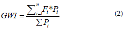
where each indicator is evaluated with a value between 1 and 10, depending on the degree of management according to each indicator in the rural region under study for a representative period of time (usually a year). If value of the denominator is equal to the number of indicators (18), it would mean that all the indicators maintain the same significant weight or importance with regard to the region analyzed. If each indicator has different values or weights, the denominator will be the sum of the weights, as shown in Equation (2), where GWI is the rural basin management index, and P is the differentiated weighting coefficient for each of the indicators according to the study area (Caro and Bladé, 2021). The following expression is proposed:
where:
GWI = rural watersheds administration index
n = number of administration indicators.
Fi = numerical result of the administration indicator i
Pi = differentiated weighting coefficient for each of the indicators according to the analyzed area
Weighting factor per indicator
The weighting factor used for each indicator represents its importance or weight within the management of a hydrographic watershed, depending on its spatial and morphometric location. Thus, the indicator of adaptability to climate change will have a greater weight if it corresponds to a watershed located in the coastal zone, in comparison with another watershed located in an area of the interior of the country with a lower morphometric accidentality (Caro, et al., 2021).
Results and discussion
The GWI method for the management and planning of water resources was directly implemented in four rural sectors of the Department of Boyacá, Colombia, a typical Andean region. The conclusions drawn from the implementation of the index allowed suggesting a procedure for the application of each of the management indicators.
Experimental methodology
This chapter describes the procedure used to obtain the GWI in some rural watersheds with consolidated local governments, aiming to determine their degree of development in terms of the supervision and administration of water and environmental resources. Before selecting the watersheds, some premises were defined to give context to the subsequent presentation of results and their analysis:
1. The selected watersheds are located in Colombia, South America, in Boyacá, a department characterized by large rural areas of agricultural use, which is naturally supported by the use of water resources.
2. The human development index for Colombia was 0,764 in 2018 (PNUD, 2020). However, this index is an average, where the lowest rating is applied to rural areas or jurisdictions. Moreover, the country still does not adequately take advantage of the water and environmental potential of rural areas to improve activities such as agriculture or natural tourism.
3. The absence of knowledge regarding water control and administration in many areas or regions of Colombia generates conditions or activities that are beneficial to the communities, but it does so in an isolated or disorganized way, which makes monitoring or control over time a difficult issue, as it generates uncertainty in some indicators, or even loss of information.
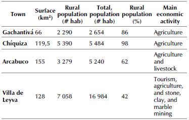
The towns selected for analysis were Arcabuco, Chíquiza, Gachantivá, and Villa de Leyva, which belong to the Cane River watershed. Their general characteristics are shown in Table 4.
A survey regarding rural areas and watersheds was applied to the state entities in charge of territorial planning in the towns.
The information collection procedure for each of the selected towns consisted of sending communications directly to the legal representatives of the towns (i.e., the mayors), while also using petition rights addressed to their respective planning and infrastructure secretaries. In these communications, the parameters of the required information are established, as well as the need to notify if it does not exist or is being procured.
Results of the experimental design
This section presents the results obtained by applying the GWI methodology given by Equations (1) and (2) for the evaluation of rural watersheds in the evaluation. It is important to keep in mind that the results are obtained from subjective information issued by the authorities of the state entities (in this case, the towns). Different values may be obtained if these indicators are applied or evaluated from an external audit entity.
For the sake of comparison, Table 5 shows the results for the four studied towns.
Table 5 Results obtained for the analyzed towns
| No. | TOWN | INITIAL DATE | FINAL DATE | GWI |
|---|---|---|---|---|
| 1 | Gachantivá | 01/06/2018 | 30/06/2018 | 1,00 |
| 2 | Chíquiza | 01/06/2018 | 30/06/2018 | 4,00 |
| 3 | Arcabuco | 01/06/2018 | 30/06/2018 | 3,21 |
| 4 | Villa de Leyva | 01/06/2018 | 30/06/2018 | 3,90 |
Source: Authors
The results show a predominance of rural watersheds over urban ones, as well as a lack of control in terms of community participation and the implementation of policies for the administration and use of water and environmental resources. In the case of the corruption control indicator, a high degree of subjectivity is evident, as this information is based on the perception of the community. The issue of corruption is a major concern for Colombian society, and yet it exhibits the highest value in most of the locations studied.
In the case of Gachantivá (GWI = 1,0), which is far from the maximum possible score, the local authorities recognized a lack of control in each of the topics covered by the indicators, clarifying that there is not necessarily a correlation between the activities carried out and the planning and control of said activities, which is evaluated by the index. Moreover, the results obtained for the town of Villa de Leyva (GWI =3,9) do not agree with what was expected, considering that their income from taxes and tourism is high in comparison with most rural towns in Colombia. Still, it reports an index lower than 5.0, which is surprising given its privileged condition. On the other hand, the town of Chíquiza (GWI = 4,0) shows the best overall performance, even without reaching the expected values. However, Chíquiza surpasses Villa de Leyva, the latter being a town with better conditions regarding income and annual budget capacity.
Considering the classification of populations by categories, in the case of Colombia, municipalities are classified in ranks from one to six, in addition to a special category, according to their number of inhabitants and their Free Destination Current Income (ICLD, for its Spanish acronym), following article 6 of Law 617 of 2000. In Gachantivá, there is a lack of historical control, so none of the indicators exceeds the values according with sostenibility which coincides with the category of the municipality (6th). It can be assumed that the resources contributed by the nation are not designated for administration tasks of this type. It is interesting to note that Villa de Leyva, Arcabuco, and Chíquiza, towns that have historically been characterized by problems with access to water, obtained their best ratings in water stress and water self-sufficiency, with a special interest in what they consider as day-to-day deficiencies or immediate needs.
It is worth highlighting the efforts made by the town of Chíquiza towards the implementation of sustainable policies, specifically regarding wastewater treatment, in compliance with the environmental regulations given by the Colombian Ministry of the Environment. Finally, in the analyzed towns and, overall, in the rural towns of Colombia, we can anticipate that there is an absence of planning culture with regard to environmental affairs.
Implementation of the final protocol
Based on the methodology proposed in this research, it is necessary to create a protocol that articulates policies and government entities with the communities in order to ascertain the reality of the administration and use of water resources, aiming to identify the strengths and weaknesses that can be improved over time. All this, without ignoring the particularities of the studied watershed's location.
The protocol covers the identification of the watersheds and the state entities in charge of the control and/or administration of water resources while considering their hierarchy within the national regulations. In the same way, it determines the responsibility of said entities in controlling and monitoring of the indicators of the GWI, which is calculated for the area and year under study. Subsequently, once the GWI index has been calculated and communicated to the legal representative of the entity with the highest hierarchy or the one in charge of monitoring, the monitoring plan is defined and implemented for the future application and recalculation of the GWI index, as well as the improvement plans based on annual feedback with the participation of all stakeholders, including the affected communities. This shows the environmental relevance of the cooperation between all actors in the use of water resources (Caro et al., 2020).
This protocol could be subject to modifications depending on the context of each basin, as well as on its country, region, or potential uses. It essentially consists of the following steps:
1. Identification of the type of basin: urban, rural, or semi-rural. It is important to clarify that the proposed methodology is adapted to rural or semi-rural basins, given the characteristics of the indicators proposed for calculating the GWI.
2. Identification of the entities, corporations, or estates responsible for the control or administration of water resources within the basin or region (hereinafter labeled as B), as well as of the entity with the highest authority in the province or department (labeled as A).
3. Determination of the responsible body (A or B) with regard to the monitoring and control of the component indicators of the GWI, by means of the legal representative the region or basin under study. The responsible person within the selected location will be called agent C and may be a natural person or a collegiate body.
4. Delivery to agent C, via the legal representative of the region or basin, of the computational tool for calculating the GWI and the manual for monitoring or implementing it, with the corresponding explanation of each indicator.
5. Quantitative determination of the indicators of the GWI methodology
6. Determination of the GWI index for the study area and year, supported by the computational tool.
7. Socialization of the index, indicators, and procedures by agent C to bodies A and B.
8. Implementation of a monitoring plan by body A for the future determination of the annual GWI and the subsequent implementation of improvement plans.
9. Annual feedback of the processes to agent B and the community of the region or basin.
10. Training plan for the community of the region or basin with regard to the environmental benefits of cooperation between users within the different systems.
Considering that, for each indicator, it is necessary to propose a defined methodology that includes the different parameters outlined in the Technical Regulation of the RAS drinking water sector and Resolution 0330 of 2017 issued by the Ministry of Housing, City, and Territory, as well as the different conditions of the rural watershed available for the supply of water resources, there must be government entities that can provide information through tools such as censuses, which allow typifying the population that benefits from the resource. Likewise, field visits and data collection allow visual inspections and measuring the current state of the hydraulic structures of the concessions (random samples), as well as comparing this information to the indicators established by the aforementioned standard. To this effect, the real conditions of the population must be verified (including the floating population), thus making it possible to obtain assertive data given the complexity of characterizing a specific area, whose conditions may vary according to the planning, development, and execution of works for supplying drinking water.
It is important to clarify that the implementation of the methodologies presented for each of the 18 indicators considers that the points, watersheds, or regions studied have defined governance structures. For different situations or contexts, this protocol may not have the same effect.
Conclusions
100% of the analyzed case studies obtained GWI values below the minimum acceptable sustainability established by the methodology.
None of the towns analyzed could be considered a sustainable process according to the GWI. The maximum value was obtained by the rural municipality of Chíquiza, with a weighted average of 4.1.
The results obtained for the indicators shows the need for improvement in many of the processes related to the sustainable management and use of water resources in the regions analyzed.
All of the indicators analyzed are applicable in the context of Colombian rural basins. Moreover, based on the above, a methodology for rural basins worldwide can be proposed, as none of the procedures used would generate a regional context failure.
The GWI was analyzed as a tool for measuring the degree of connectivity between the different levels at the rural basin level (upper, middle, and lower basin), its main actors (community, service providers, and the State), and the degree of management of water and environmental resources. The GWI is based on 18 indicators that are evaluated in consecutive periods of time in order to establish the degree of improvement in management over time. The index involves aspects of water and environmental management, infrastructure, biodiversity, political control, and corruption levels, and it assigns a specific weight to each indicator according to the context of the region or area.
According to the results, the proposed protocol suggests management alternatives that can be applied worldwide while considering the local context.

