


Services on Demand
Journal
Article
 English (pdf)
 Article in xml format
 Article references
 Send this article by e-mail
Indicators
-
 Cited by SciELO
 -
 Access statistics
Related links
-
 Cited by Google
 -
 Similars in
SciELO
Similars in
SciELO -
 Similars in Google
Share

 Permalink
Earth Sciences Research Journal
Print version ISSN 1794-6190
Earth Sci. Res. J. vol.9 no.2 Bogotá July/Dec. 2005
SEISMOLOGICAL OBSERVATORY AT QUINDIO UNIVERSITY (O.S.Q.): A FIRM LONG-TERM STEP TOWARD RESOLVING REGIONAL SEISMICITY
Monsalve Jaramillo Hugo1,2, Correa Montaño Isabel Cristina1,2, and Valencia Mina William1
1 CEIFI, Quimbaya Research Group - Quindío University
2 Seismological Observatory at Quindío University - OSQ. E-mail: hugom@uniquindio.edu.co
RESUMEN
El Eje Cafetero (zona central de Colombia, cultivada con café), y en particular, el departamento del Quindío es constantemente golpeada por sismos de diferentes magnitudes. Los sismos son el resultado de la compleja tectónica regional debido a la interacción entre las placa Nazca, Caribe y Sur América. La convergencia de estas placas es responsable de la formación de los Andes. Por estas razones, el OSQ (Observatorio Sismológico del Quindío) e INGEOMINAS, como las entidades estatales encargadas de monitorear la actividad sísmica, han de contribuir, a si como los centros regionales de investigación, al desarrollo de los estudios sismológicos y el análisis de la actividad tectónica local, para así obtener nuevos conocimientos a cerca de los desastres naturales que amenazan a las comunidades en la región y entender mejor la estructura interna de la corteza en la región del Eje Cafetero.La combinación de diferentes modelos de velocidad para la región del Eje Cafetero ha permitido la definición de elementos clave para tener una mejor percepción de la estructura de la corteza. En consecuencia, la determinación de un modelo de velocidades mejorado para la región cafetera ha ayudado a localizar mejor los sismos y a determinar con mayor precisión los espesores de la corteza y la estructura del manto superior entre los terrenos adyacentes que fueron generados en diferentes períodos geológicos.La magnitud ML fue determinada para los campos cercanos e intermedios y usando el modelo presentado en este articulo, el problema del rango dinámico de saturación de los sismógrafos durante sismos relevantes en campo cercano es solucionado. La magnitud local de algunos sismos superficiales fue calculada usando sismos con distancias epicentrales entre 10Km y 300Km asi como las magnitudes de algunos sismos profundos con distancias hipocentrales entre 100 Km y 600 Km.La evaluación del potencial sísmico en la región del Eje Cafetero empieza con el registro de la sismicidad reciente en Chocó y en la parte norte del departamento del Valle, y está basada en el análisis comparativo entre esta sismicidad y la registrada antes de la ocurrencia de los sismos mas importantes de los últimos 42 años. Finalmente, considerando las dos fuentes de subducción, un sismo cuya magnitud de momento sísmico entre 6.7 y 7.3 podría esperarse en la próxima década, con una probabilidad de 87%.
Palabras clave: Quindío, sismicidad, instrumentación.
ABSTRACT
The Coffee Belt (the central coffee-growing zone in Colombia), and more particularly, the state of Quindio is constantly hit by earthquakes of different magnitudes. Earthquakes result from the complex regional tectonics, brought about by interaction between the Nazca, Caribbean, and South American plates. The convergence of these plates is responsible for the formation of the Andes. For these reasons, the OSQ (Sesimological Observatory of Quindio, from its acronym in Spanish) and INGEOMINAS, as government offices in charge of monitoring earthquake activity, have to contribute, along with research centers of the region, to the development of seismological studies and analysis of local tectonic activity in order to obtain new knowledge regarding natural disasters which are threat to the communities in region and be able to better understand the internal crustal structure in the Coffee Belt region. The combination of different velocity models for the Coffee Belt region has allowed the definition of key elements to have better insight about the structure of the crust. Consequently, determining an improved new velocity model for the Colombian coffee-growing region has helped to a better location of earthquakes and to a more accurate determination of differences in crustal thickness and the structure of the upper mantle between adjacent terrains that were built during different geological periods. The ML magnitude was determined for the near and intermediate fields, and, using the model presented in this article, the problem of dynamic range saturation of seismographs during relevant earthquakes in near field is overcome. The local magnitude of some shallow earthquakes was calculated using shocks with epicentral distances ranging between 10km and 300km as well as the magnitudes of some deep earthquakes with hypocentral distances ranging between 100km and 600km.Seismic potential assessment in the Coffee Belt region begins with recent seismicity recorded in Chocó and the northern part of Valle (a state in Colombia) and is based on comparative analysis between this seismicity and the one recorded before the occurrence of the most important earthquakes in the last 42 years. Finally, taking into consideration the two subduction sources, an earthquake with seismic moment magnitude ranging between 6.7 and 7.3 could be expected within the next decade, having a probability of 87%.
Key words: Quindío, sismicity, instrumentation.
INTRODUCTION
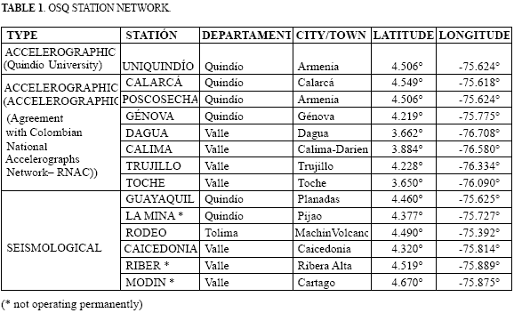
As a result of the emergency caused by the January 25, 1999, Mw 6.2 Quindio earthquake, Quindio University and INGEOMINAS worked jointly in the installation and operation of a temporary seismograph network, assigning this responsibility to the Studies and Research Center of the Engineering Faculty (CEIFI) which became, since February 1999, the seismological observatory of Quindio University, using telemetry instruments, seismographs, and accelerographs borrowed from INGEOMINAS in order to monitor the aftershocks. Currently, there are eight accelerographs in operation and six telemetered seismograph stations (Table 1), five of which are located in Armenia and one in Manizales (RODEO, which belongs to Manizales Volcanological and Seismological Observatory OVSM).Since May 1999, when the observatory began operations, and up to now, the O.S.Q. has been in charge of carrying out seismic monitoring activities in Quindio associated to active faults in the area, however, other local and relevant worldwide seismic activity is also detected.In terms of knowing regional seismicity, the information collected by the local network has been of vital importance in understanding the local geodynamic processes related to urban planning and risk management activities in the region, identifying seismic sources, activity that CEIFI has been conducting. In addition, the information that is analyzed and provided by CEIFI is, and has been, of great support to different government officials involved in civil protection and disaster prevention activities in order to carry out programs of information diffusion and disaster management.
A seismograph network is a useful tool to know the inner structure of the Earth, earthquake waves propagation patterns, earthquake-source mechanisms, as well as urban seismic microzoning and hazard assessment of a specific region. For this purpose, it is necessary to have qualified staff that is trained in processing and analyzing data, capable of improving their knowledge of seismic phenomena and generating new hypothesis regarding seismic behavior of the studied region. The installation of an observatory in a region enables gathering of valuable information to conduct studies and increase the knowledge of local seismicity as well as studies about the regional crustal structure. The observatory becomes thus a frim long-term step to help resolve regional seismicity
OSQ GOALS
Given the fact that Quindio department and the Coffee Belt region as well as other zones in the country are usually threatened by earthquakes, the seismological observatory has as top priority goal of offering logistic support to the research center for the analysis of tectonic activity in the state of Quindio for which constant monitoring, recording, and broadcasting activities are being carried out 365 days a year. In order to generate new knowledge about the natural hazards to which the region is constantly exposed, research projects are developed. These projects allow knowing, assessing, and improving social development conditions and subsoil conditions to provide early advise on disaster prevention and the determination of potential areas for future urban development of engineering works.
REGIONAL TECTONIC SETTING
The state of Quindio has geological units of oceanic and continental origin which date back to Paleozoic and Mesozoic ages (Arquia complex, Quebradagrande complex, ultrabasic rock fragments, and Cordoba igneous complex) which are intruded into by igneous units from the late Mesozoic and overlaid by tertiary sedimentary sequences. These units, which comprise the regional geological basement, are separated by big regional faulting and are covered by a big fluvio-vocanic unit of Quaternary age, Quindio and Pereira fans, and by local Quaternary units. The general geological and tectonic schemes are presented in figure 1 (Espinosa A. 2005).
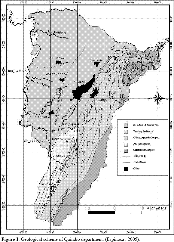
From the tectonic point of view, The state of Quindio sits on the Romeral fault system. The three main faults of the system, Cauca–Almaguer, Silvia–Pijao, and San Jerónimo, go across the region with strike component N15E. The importance of those faults through the geological history of the zone has been unquestionable, but its activity during the Quaternary has been inconsistent (Espinosa A. 2005).Seismic activity in this zone locates between isodepths of 80-160km within the Wadati-Benioff zone of Nazca plate, which subducts along the Colombian northwest (Monsalve, 1998), and also along numerous crustal faults. Out of these faults, the most noticeable are Cordoba, Navarco, Silvia-Pijao, Buenavista, El Salado, Cauca-Almaguer, Armenia, Salento, Montenegro, Palestina, and Cauca-Patía faults which are active faults with probable magnitudes ranging between 6.1 and 6.9 Mw (Guzmán, 1998). Taking into consideration all this tectonic complexity, the seismological observatory at Quindio University (OSQ) contributes to the development of projects that generate new knowledge about the hazards that threaten the region, in order to improve plans and processes regarding both disaster mitigation and disaster prevention.
SEISMICITY OF QUINDÍO DEPARTAMENT 1999 - 2005
Colombia is located in one of the most active seismic regions of the world dubbed “The Pacific Ring of Fire”. Colombia’s tectonics is complex because of the convergence of three plates: Nazca, South American, and Caribbean plates. These plates interact with one another originating compression, tension, and shear stresses within the region, which in time cause accumulation of energy. This interaction has originated three mountain ranges: The Western, The Central, and the Eastern ranges, being the central one the oldest of all, and the eastern one the youngest. The most active zones in terms of seismic activity are located throughout the Andean region of the country, along which the mountain ranges are settled; all this forms thus a complex morphological setting that is currently object of research. Quindío department is located in the Andean region of Colombia, more exactly, to the western flank of the Central Mountain Range. Its boundaries are defined by Risaralda department to the north, Tolima department to the east, and Valle del Cauca to the southwest. For the geological complexities previously mentioned and the critical location, it is obvious that the Coffee Belt region is prone to significant shaking from earthquakes.
Quindío department is one of the most seismically active areas in Colombia. This was confirmed by the occurrence of the January 25th Quindio earthquake (1999), which took place at 18:19:16 UT (13:19:16 HL), with a magnitude Mw=6.2 and a depth of 18 Km. A Mw 5.5 aftershock occurred at 22:40:12 UT (17:40:12 HL) the same day. The main shock ruptured along a left strike slip with normal component fault surface. This faulting located at shallow depth in the continental crust. Its rupture length was 11.7 km and 10.6 km width; this yields a total rupture area of 124 km2. 391 well-identified and well-located aftershocks were used to constrain the rupture area. The aftershocks were recorded between depths of 9 and 20 km (Monsalve y Vargas 2002).This seismic event was the largest shallow earthquake instrumentally-recorded ever in the Coffee Belt region. Its epicenter was located near Cordoba (a municipality of Quindio department) 17km from Armenia. The death toll was 1,185; about 8,523 were injured, and more than 100.000 constructions were affected in 28 municipalities of three states (Quindío, Risaralda, Caldas, Tolima y Valle) (Monsalve et al, 2002).
Between February 1999, and August 2005, the OSQ has recorded 13.607 events (Table 2). Not all of them have been located due to the little coverage of the network. The events (Figure 4), which have been located with the velocity model mentioned above, have yielded magnitudes ML ranging between 0.04 and 6.2, all of them having shallow depths. (For further information about the earthquakes location, see the location catalog on the OSQ web page: http://www.uniquindio.edu.co menú Investigaciones, CEIFI, Grupos, O.S.Q )

Between May 1st, 1999 and March 31st, 2000, 4,256 aftershocks were recorded. This produced a maximum daily rate of 58 events (October 21st) and an average of 15 events/day. We point out that during June 1999, a maximum number of 56 events took place and the minimum were registered during December 1999 - March 2000, yielding an average of 14 and 13 earthquakes respectively (Figure 3). In general, the occurrence of aftershocks continues with a fast exponential decrease rate as a function of time.


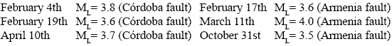
The seismicity during 1999 remained at high levels most of the year as a result of the numerous aftershocks generated by January 25th earthquake (1999). During the year 2000 seismicity was low, except during April 10th - 11th where 108 and 115 earthquakes/day were registered. Because of their magnitude, the following events were remarkable during the year 2000 catalog:
Seismicity during 2001 had its highest level during the period February - May. The events occurred on January 16th 09:56 PM (local time), and March 2nd 06:46 and 06:47 (local time), were felt in Pijao and felt in the southern part of Armenia, respectively. The first of them had a ML magnitude of 3.1 and was located 8.3km southwest of Armenia. During 2002 and 2003 seismic activity remained very low, with mild increase from May to June 2002, and June and November 2003.The three first months of 2004, seismicity levels were very low with a subtle increase in April with increases in activity on the 19th and on the 20th during which 76 local earthquakes whose magnitudes ranged 0.6 and 2.9 ML. two of which were felt in Armenia and Calarcá. The first, April 19th at 04:04 local time (09:04UT), had a ML magnitude of 2.9. The second, same day (19:19 UT), reached a magnitude 2.3 ML. The following days seismic activity remained normal until September, where a significant increase in activity arose, with an important event on November 15th at 4:06 am local time with magnitude 6.7 in Richter scale and epicenter located in the Pacific Ocean, 50.7 km to the southwest of Bajo Baudó (Choco).Until 2005, seismicity continues to be stable and it is worth mentioning the occurrence of an earthquake (June 22nd, 2005) at 03:07am local time (08:07 UT), with magnitude of 4.5 ML, 12.92km deep. This event was strongly felt in the whole Quindío and in some municipalities of Risaralda state. There were no casualties or material losses. More than 336 aftershocks were reported until June 30th, all of them having magnitudes noticeably inferior to the main shock. The aftershock occurred the same day at 09:25 AM local time, with a magnitude ML of 2.9 which was felt in some towns near Calarcá. This seismicity is associated to the tectonically active area of Quindio department around Cordoba municipality and is directly related to the activity that originated the January 25th earthquake in Armenia in 1999.
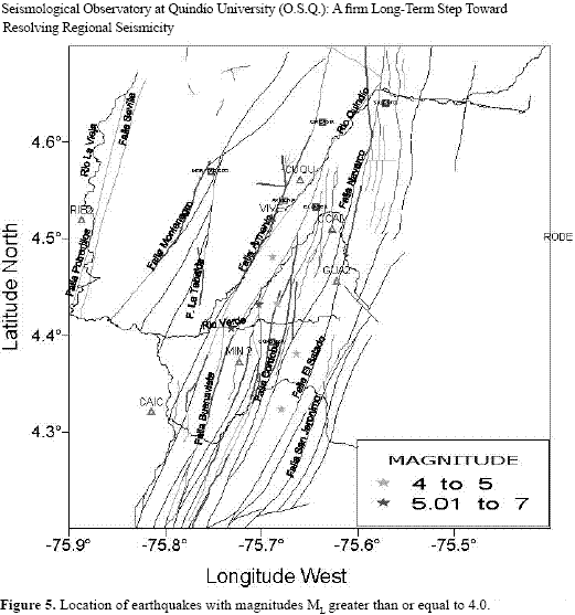
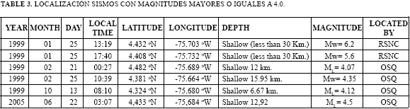
Six events with magnitudes ML equal to or greater than 4.0, from 1999 to 2005 are shown in Figure 5.The OSQ recorded four of these six local earthquakes; the other two are relate to the seismic activity occurred on January 25th, 1999 and were located by the Colombian National Seismograph Network (RSNC, from its acronym is Spanish) in view of the fact that then, Quindio University had not fully set up the seismological observatory and started its activities.
MODEL FOR THE LOCATION OF SEISMIC EVENTS
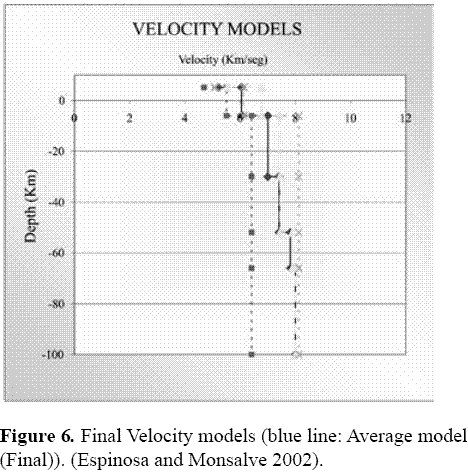
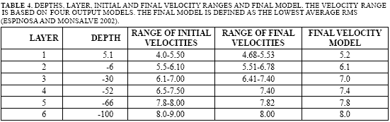
In order to locate the earthquakes registered by the OSQ, the phase information recorded by different stations of OVSM and OSSO was required, and the model developed by (Espinosa and Monsalve, 2000) was used. This model is a one-dimensional velocity model derived for the Coffee Belt region using seismic tomography and well-located earthquakes between 4ºN and 6ºN within the Coffee Belt region with the software HYPO71 and the non-linear ray inversion method VELEST. These earthquakes were later relocated using the Joint Hypocentral Determination (JHD), (Dewey, 1971) in order to verify the quality of the model generated for this zone (Espinosa y Monsalve 2002).The data used for velocity structure inversion included 566 earthquakes suitable for a good model (out of 1,337). The quality of the located events was high: RMS= 0.057 s, 12km deep, average magnitude of 1.25 and a gap of 158º. From a seismological point of view, a good velocity structure model is important to obtain location of events, as well as reliable source parameters to understand ground shaking during strong ground motionThe results obtained with the one-dimensional model show a uniform distribution of velocities. The final result of the inversion using an initial model shows a velocity model of flat layers with a good resolution of superficial layers (0-100km depth). However, for deeper layers the resolution is not really good, because most earthquakes located at shallow levels and there are not many seismic rays that cross those regions (Espinosa and Monsalve 2002).Considering the results of different inversions, we model the continental crust for the Coffee Belt region as consisting of six flat layers where the Moho is situated, from 30 to 35km deep. The wave velocities up to 100km depth, are: 6.0km/s at depths of 6km, 7.0km/s at depths of 24km, 7.4km/s for a 22km-thick layer, 7.8km/s for a 14km-thick layer, and finally, a zone with velocities of 8km/s (Figure 6).
This study allowed to establish a velocity model for the crust below the zone as well as to understand better the tectonic features of the region, which is important to have more accurate knowledge of the crustal structure in the Colombian Coffee Belt and therefore to improve local earthquake hazard assessment studies.
CALCULATION OF LOCAL MAGNITUDE (ML) USING STRONG MOTION ACCELEROGRAMS
Besides earthquake location, it is really important to obtain the local magnitude for strong earthquakes using the accelerograms. For this purpose, the method proposed by Barragán (2003) is used. This method was developed processing the most important time history records of shallow events (39 events) and events of intermediate depth, (40 events) that have occurred in the central region, Los Santanderes region, and the western region of the country which were provided by the Colombian National Accelerograph Network (RNAC), from 1994 to 2001. The accelerograph records are used as an acceleration input to the equation of motion of the Wood-Anderson torsion seismograph to produce synthetic seismograms which is then read in the standard manner thus permitting an easy and dependable calculation of the local magnitude ML of important events (Barragán 2003). the Colombian National Accelerographs Network (RNAC) reported a magnitude ML 6.2 for Quindio earthquake (January 25th, 1999), and with this method, a magnitude ML 6.22 was calculated using the complete procedure and records from 23 accelerographic stations; and a magnitude ML of 6.10 using a preliminary procedure with records of 26 stations (Barragán L. F. 2003) which confirms the reliability and simplicity of the method. To have a summary of the process to calculate ML with the method proposed by Barragán (2003), let us start by the data that is collected during normal processing activities; it includes instrumental and baseline correction of the records as well as their separation into three orthogonal components: Vertical, East-West, and North-South. Using the software DEGTRA for windows version 1.4.7, maximum registered amplitudes in cm/s2 are obtained from the horizontal components (East-West and North-South) and the formula (Barragán, 2003) used for shallow or intermediate earthquakes is applied as follows:
• For shallow earthquakes an empirical expression is proposed in order to directly determine local magnitude ML using horizontal ground accelerations

Where Aace is the maximum amplitude in cm/s2 (from zero to maximum) registered by an accelerograph set on the bedrock for a particular earthquake at a specified distance and Δ is the epicentral distance.
• For intermediate depth earthquakes between 70 and 300km deep, another empirical expression for the direct calculation of local magnitude ML using horizontal ground acceleration

Where Aace is the maximum amplitude in cm/s2 (from zero to maximum) registered by an accelerograph set on the bedrock for a particular earthquake at a specified distance and ? is the hypocentral distance in km.These equations are only applicable to horizontal strong motion components of accelerograph records.In this way, the local magnitude of earthquakes in the near field is calculated, using strong motion accelerograms and applying this to the regional geotectonic setting.
EARTHQUAKE POTENTIAL IN THE COFFE BELT REGION
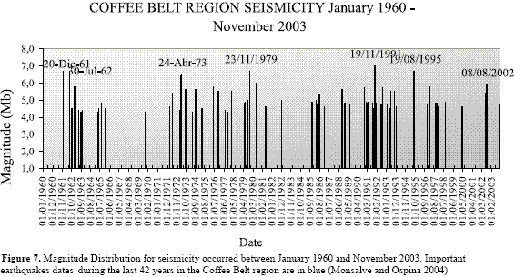
Earthquake potential was assessed based on the seismicity registered in northern Valle and Chocó. Comparative analysis were done between this seismicity and the one that took place before the occurrence of the most important historical earthquakes that have affected the region during the last 42 years. All this information about the seismicity, registered from 1961 to 2003, was compiled based on the minimum magnitude threshold of Ms> 4.4. This refers to seismicity that has been experienced in the region (Figure 7) which, because of the lack of a national seismological network at the time, it was necessary to resort to the USGS-NEIC catalog. With this catalog, the comparative analysis was performed. This analysis comprised the seismicity that took place before the occurrence of the most important earthquakes that have struck the Coffee Belt region during the last 42 years. Through this analysis, it was possible to find a time span (in years) of events recurrence that will repeat in the different sources any time within the next decade. Knowing this, and the type of faulting mechanisms associated to the different zones, it is possible to obtain better insight of the earthquake potential in the region (Monsalve y Ospina 2004).According to the observation of these recurrence patterns an earthquake of magnitude (Mw) ranging from 6.5 to 7.2 could be expected at the subduction zone H=120km between Filandia and Circasia which would occur the next decade with a probability of 57% and intensities up to VII (EMS-92 intensity scale). Similarly, an earthquake of magnitude (Mw) ranging from 6.7 to 7.3 in the subducton zone H=60 km, within Risaralda and Chocó states would occur the next decade with a probability of 51% and intensities up to VIII or greater in EMS-92 scale. Finally, considering the two subduction zones altogether, an earthquake of magnitude (Mw) from 6.7 to 7.3 could be expected the next decade with a probability of 87%.
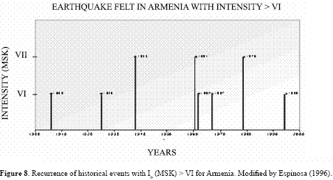
In Armenia the panorama of the last hundred years is quite clear. It can be observed that earthquakes with intensities equal to or greater than VII have a recurrence of about 20 years; there is a return period between 12 and 13 years for events with intensities equal to or greater than VI. It can also be observed that with recurrence of at least 5 years, earthquakes that may cause important damage have struck and will probably strike the region (Monsalve y Ospina 2004).
Historically, there are several earthquakes occurring at deep and intermediate subduction sources (60-220km deep). Among them, we draw attention to the earthquakes that are remarkable because of their destructive potential. First, the one occurred on December 20th 1961 (Mb=6.3, 176 km. deep), July 30th, 1.962 (Mw=6.7, 108 km. deep), November 23rd, 1979 (Mb=6.4, 108 km. deep), and February 8th, 1995 (Mw=6.6, 100 km. deep); which have directly affected Quindío and Risaralda department (Monsalve, Ospina 2004). In figure 9, earthquakes with seismic moment magnitude 5.0< Mw < 7.2 in northwestern Colombian are shown (Monsalve 1998).
CONCLUSIONS
In earthquake-prone zones, such as the Coffee Belt region, it is of paramount importance to know and understand the response of structures to the high seismic activity and resulting hazard that this region faces. This can be achieved by specialized and detailed analyses which can lead to the improvement of earthquake hazard assessment studies in the region.All the studies carried out in the Coffee Belt region have provided people with knowledge and understanding geological and tectonic characteristics in the zone, thus making it possible to take a step further in the knowledge of crustal structure underlying this region. The answer to many seismological questions may be furnished by the installation of this local network.Through the development of different projects that have been conducted since the OSQ started operations, new knowledge regarding the natural hazards that the Coffee Belt region is exposed to has been generated. These projects have allowed us to evaluate, and improve the social development conditions, and determine regional subsoil conditions to provide early control in terms of disaster prevention and the determination of potential areas for future urban development of engineering works.
REFERENCES
• Barragán, L.F. (2003). Determinación de la Magnitud Local ML a partir de Acelerogramas de Movimiento Fuerte. Bachelor thesis, Civil Engineering. Quindío University. [ Links ]
• Dewey, J.W. (1971), Seismicity studies with the method of join hypocenter determination: Ph. D Thesis, University California Berkeley. [ Links ]
• Espinosa, A., 1996. Sismicidad histórica del área Pereira-Dos Quebradas-Santa Rosa de Cabal. Informe final sismicidad histórica, seismic risk mitigation project Pereira- Dos Quebradas and Santa Rosa de Cabal. CARDER, Pereira, 40 p., inédito. [ Links ]
• Espinosa, A., (2005). Un modelo del Cuaternario del Quindío y Risaralda. Journal of the Colombian academy of physical, natural, and exact sciences, Bogotá. [ Links ]
• Espinosa-Ospina, L. and Monsalve-Jaramillo, H. (2002). Determinación de un Modelo Unidimensional de Velocidades para el Eje Cafetero Colombiano Utilizando Tomografía Sismica. Bachelor thesis, Civil Engineering. Quindío University. [ Links ]
• INGEOMINAS (1999). Terremoto del QuindÍo (Enero 25 de 1999). Technical-scientific report. Bogotá. [ Links ]
• Mc Court, W.J., Aspden, J.A., Brook, M., (1984a). New geological and geochronological data from the Colombian Andes: continental growth by multiple accretion. J. Geol. Soc. London, 141 (5), 831 - 845. [ Links ]
• Monsalve, H., 1998. Geometría de la Subducción de la Placa Nazca en el Noroeste de Colombia: Implicaciones tectónicas y sísmicas, Master thesis, Instituto de Geofísica, Universidad Nacional Autónoma de México, 106 p. [ Links ]
• Monsalve-Jaramillo, H. and Ospina-Ostios, L.M. (2004). Potencial Sísmico de la Zona de Subducción en el Quindio y Risaralda (Colombian Coffee Belt region). [ Links ]
• Monsalve-Jaramillo, H. and Vargas-Jiménez, C.A. (2002). El Sismo de Armenia (25-01-99, Mw=6.2): Análisis telesísmico y características de las ondas de cuerpo. Journal IPGH, No 57, 21-56. [ Links ]
• Monsalve, H., Castaño, P., Díaz, J., Fernández, A., Pérez, A., Calero, L. and Pinzón, G (2002). La Reconstrucción del Quindío Lecturas desde la Academia. Quindío University. Armenia - Colombia. [ Links ]
• París, G., and Marulanda, N., (1975). Mapa geológico de la parte occidental de la plancha 387 - Bolívar, scale 1:100.000. INGEOMINAS - Popayán, inédito. [ Links ]
• Trenkamp, R., Mora, H. and Salcedo, E. (2004). Possible rapid intrablock strain accumulation rates near Cali, Colombia determined from GPS measurements (1996-2003). First Latin American Congress of Seismology. Armenia (Colombia). [ Links ]
• Vargas, C.A. and Carvajal, C.A. (1998). Estudio de refracción sísmica de Armenia-Quindio. Journal Red Sismológica Regional del Eje Cafetero - Viejo Caldas y Tolima. 3:16-23. ISSN:0123-9074. [ Links ]

