


Servicios Personalizados
Revista
Articulo
 texto en
  Español (pdf)
 Articulo en XML
 Referencias del artículo
 Enviar articulo por email
Indicadores
-
 Citado por SciELO
 -
 Accesos
Links relacionados
-
 Citado por Google
 -
 Similares en
SciELO
Similares en
SciELO -
 Similares en Google
Compartir

 Permalink
Boletín de Investigaciones Marinas y Costeras - INVEMAR
versión impresa ISSN 0122-9761
Bol. Invest. Mar. Cost. vol.48 no.2 Santa Marta jul./dic. 2019 Epub 13-Dic-2019
https://doi.org/10.25268/bimc.invemar.2019.48.2.764
Research Articles
Climate change and socioeconomic impacts on the Colombian coastal and insular area

1 Instituto de Investigaciones Marinas y Costeras "José Benito Vives De Andréis" INVEMAR, Santa Marta D.T.C.H., Colombia. desiree.hernandez@invemarorg.co.
2 Instituto de Investigaciones Marinas y Costeras "José Benito Vives De Andréis" INVEMAR, Santa Marta D.T.C.H., Colombia. alejandra.vega@invemar.org.co.
3 Instituto de Investigaciones Marinas y Costeras "José Benito Vives De Andréis" INVEMAR, Santa Marta D.T.C.H., Colombia. anny.zamora@invemar.org.co.
4 Instituto de Investigaciones Marinas y Costeras "José Benito Vives De Andréis" INVEMAR, Santa Marta D.T.C.H., Colombia. paula.sierra@invemar.org.co.
Climate change has a global-level impact, with effects on natural and human systems, and in particular coastal zones have been recognized as area sensitive to threats of sea level rise (SLR) and coastal erosion. This exercise was carried out in order to identify the impacts of climate change at a socioeconomic level in Colombia's coastal zone, which is composed of 12 departments with 60 municipalities framed within ten Coastal Environmental Units (UAC). Methodologically, 23 indicators were defined using the risk approach, that combines the exposure (14 indicators), sensitivity (6 indicators) and adaptive capacity (3 indicators), framed within food security, human habitat, and infrastructure dimensions. To do this, official information databases were built regarding the socioeconomic elements exposed, combined with the use of the SLR and coastal erosion-affected areas report, elaborated by Invemar within the Third National Communication on Climate Change framework. With this report data, indicator matrices were built and the levels of affectation in each indicator were calculated using distribution by quintiles. The results show that towards the year 2100, about 5% of the population and 4.3% of houses will be affected by SLR, especially in the Guapi and Mosquera (Cauca) and La Tola (Nariño) municipalities in the Pacific region and Remolino, Sitio Nuevo and Pueblo Viejo (Magdalena) municipalities in the Caribbean. In addition, tourist areas could lose 13% due to coastal erosion, and 5.9% of the port infrastructure and 12% of the roads could be flooded by SLR. These results constitute an input to support territorial planning, as well as the formulation of municipal and sectoral plans for climate change management on Colombia's coasts.
KEYWORDS: Indicators; Vulnerability; Threat; Coastal Marine; Climate Change
El cambio climático tiene incidencias a nivel global, con efectos sobre los sistemas naturales y humanos, y en particular las zonas costeras han sido reconocidas como áreas sensibles a las amenazas de ascenso en el nivel del mar (ANM) y erosión costera. Este ejercicio se realizó con el fin de identificar los impactos del cambio climático a nivel socioeconómico en la zona costera de Colombia, compuesta por 12 departamentos que abarcan 60 municipios enmarcados en diez Unidades Ambientales Costeras (UAC). Metodológicamente, se definieron 23 indicadores utilizando el enfoque de riesgo, que conjuga la exposición (14 indicadores), sensibilidad (6 indicadores) y capacidad adaptativa (3 indicadores), enmarcados en las dimensiones de seguridad alimentaria, hábitat humano e infraestructura. Para esto, se construyeron bases de datos con información oficial sobre los elementos socioeconómicos expuestos y se empleó el registro de las áreas afectadas por ANM y erosión costera elaborados por Invemar en el marco de la Tercera Comunicación Nacional de Cambio Climático. Con estos datos se construyeron las matrices de indicadores y se calcularon los niveles de afectación en cada indicador utilizando la distribución por quintiles. Los resultados muestran que hacia el año 2100 cerca de 5% de la población y 4,3% de las viviendas se afectarían por ANM, especialmente en los municipios de Guapi, Mosquera (Cauca) y La Tola (Nariño) en la región pacífica y Remolino, Sitio Nuevo y Pueblo Viejo (Magdalena) en el Caribe; además, las áreas turísticas podrían perder 13% a causa de la erosión costera y 5,9% de la infraestructura portuaria y 12% de las vías podrían inundarse por ANM. Estos resultados son un insumo para apoyar la planificación territorial, así como para la formulación de los planes municipales y sectoriales de gestión del cambio climático a nivel costero en Colombia.
PALABRAS CLAVE: Indicadores; Vulnerabilidad; Amenaza; Marino Costera; Cambio Climático
INTRODUCTION
The effects of climate change have been evident at global level, with negative impacts reflected in both natural and human systems all over the planet, with coastal areas being recognized as particularly sensitive to this phenomenon (IPCC, 2014; Vides and Sierra-Correa, 2014; Petzold and Beate, 2015; Tragaki et al., 2018; Armanfar et al., 2019). In this respect, the Intergovernmental Panel on Climate Change (IPCC) prepared five assessment reports on impacts, vulnerability and adaptation to climate change observed worldwide, providing guidelines for the continuity of more detailed studies (IPCC, 1990, 1995, 2001, 2007, 2014).
The United Nations Framework Convention on Climate Change (UNFCCC), defines this phenomenon as follows, "a change of climate which is attributed directly or indirectly to human activity that alters the composition of the global atmosphere and which is in addition to natural climate variability observedover comparable timeperiods", whose persistence generally lasts for decades or more (IPCC, 2014; Camare and Lane, 2015). Likewise, the IPCC defines vulnerability as the propensity or predisposition to be adversely affected, a concept based on exposure, sensitivity and the capacity to cope and adapt. Exposure is the presence of elements (people, means of subsistence, ecosystems, environmental resources, infrastructure, economic, social or cultural assets) in places or environments that could be negatively affected. Sensitivity is the degree to which a system or species is affected by climate change; this term is directly related to the socioeconomic, natural and political conditions of a population, and therefore depends on its access to resources and their management. Finally, adaptive capacity refers to the ability of systems, institutions, individuals and other agencies to adapt to damage, seize opportunities, cope with consequences and moderate or avoid losses (Klein et al,, 2001; Gallopín, 2006; Olivo-Garrido et al, 2012; Lampis, 2013; IPCC, 2014).
The impacts of climate change are defined as the effects, consequences and results on natural and human systems caused by this phenomenon and to the vulnerability of exposed societies or systems. They are the product of threats, corresponding to changes in atmospheric temperature, changes in precipitation, sea level rise (SLR), coastal erosion, marine acidification and changes in sea surface temperature (SST). Coastal systems are particularly sensitive to SLR, SST, marine acidification and coastal erosion (Diez, 2000; IPCC, 2014; Slangen et al., 2014).
The impacts have repercussions at the socioeconomic level, on human settlements, on economic activities and on living conditions. In this sense, vulnerability is determined by inequality in access to resources and not only by the impacts of natural events (Yáñez-Arancibia, 2014; Mussetta et al., 2017).
Thus, SLR is expected to cause negative impacts such as immersion, flooding, and coastal erosion. In turn, exposure could increase in future decades due to increased population and economic assets (goods and services) (Diez, 2000; IPCC, 2014). It is estimated that countries located at low latitudes, specifically in Central and South America, will face strong impacts and damage due to floods caused by SLR, reflected in high restoration and adaptation costs (Day et al., 2000; IPCC, 20114, 2014; Wong et al., 2014). Such is the case for countries such as Venezuela, Uruguay, and Peru, which according to a number of studies (Giménez and Lanfranco, 2012; Tejeda, 2018; Nagy et al., 2019) could suffer the socioeconomic consequences of the effects on coastal human habitats, productive activities (e.g., tourism), and infrastructure. In Venezuela, SLR and coastal erosion risks were identified for two areas (Cabo Codera-Parque Nacional Laguna de Tacarigua and Barcelona-Puerto La Cruz-Guanta), both with high levels of vulnerability, exacerbated by anthropogenic interventions (Olivo et al., 2001).
There are also cases such as the Peloponnese (southern Greece), where seven municipal communities along the northwest coast were identified as high risk and very high vulnerability to the threats of climate change (Tragaki et al., 2018). In Malaysia, negative impacts are expected on economic activities such as agriculture and forestry, biodiversity, coastal and marine resources, public health and energy (Kuok Ho, 2019). In Mexico, the most vulnerable area on the coasts of the states of Tabasco and Campeche includes 437,836 inhabitants of port cities that could be affected by flooding due to SLR (Ramos-Reyes et al., 2016). In Argentina, 25% of the lowlands in the province of Río Negro are highly vulnerable due to SLR and marine erosion (Kokot et al., 2004). Meanwhile, in Brazil the beaches of the state of Bahia will be reduced by the effects of coastal erosion, and tourist facilities and spaces will be affected by flooding caused by the SLR (Da Cruz, 2009).
In the national context, there have been three National Communications to the United Nations Framework Convention on Climate Change (UNFCCC) (IDEAM-UNDP, 2001, 2010; IDEAM et al, 2017). The First National Communication (2001) analyses the 1990-1994 period. The results indicate that SLR of one meter, towards the end of the 21st century, would affect 1.4 million of the country's inhabitants (4%). The vulnerability of housing in the Caribbean region is 9% in urban areas and 46% in rural areas. In the Pacific, this proportion reaches 45% (IDEAM - PNUD, 2001).
In the Caribbean region, the results foresee flooding by SLR in agricultural areas, with a proportion of 4.9%; specifically, banana will be affected by 39.2% and African palm by 9.7%, with economic repercussions for the city of Santa Marta and the department of Magdalena. In the industrial sector, 75.3% of the areas occupied by manufacturing establishments in Barranquilla and 99.7% in Cartagena will be affected. And finally, 44.8% of terrestrial road infrastructure is highly vulnerable (IDEAM - PNUD, 2001).
In 2010, the Inter-American Development Bank (IDB) conducted a study of vulnerability and adaptation to climate change in Mesoamerica with results indicating high sensitivity in Colombia's coastal areas. Besides the various elements exposed in these areas, such as agriculture and population centers, high levels of poverty are added as a determining factor of sensitivity to the effects of climate change (BID, 2010).
Similarly, the Second National Communication on Climate Change was prepared in 2010, analyzing the years 2000 and 2004. The results indicate that, in the Caribbean region, 51% of urban areas will suffer flooding by SLR and in the Pacific, this figure rises to 63% with losses mainly in terms of infrastructure. In terms of coastal population, 9,000,000 inhabitants are projected for the year 2030, of which 4% will be affected by the same threat (Caribbean: 80%, Pacific: 20%). For the agricultural, livestock, industrial, forestry and mining sectors, the GDP affected will be between 0.4% and 3% by 2100, and damage due to the loss of hotel infrastructure will reach 12 million dollars (IDEAM - PNUD, 2010).
The studies on vulnerability to climate change for Colombia carried out at national and even departmental levels served as reference to develop a vulnerability analysis within the framework of the Third National Communication on Climate Change (TCNCC), conducted at municipal level for the country's coastal zone. In it information regarding the socioeconomic component for this area was updated, this being the subject of interest for this document. Thus, socioeconomic variables were crossed with SLR and coastal erosion threat models at local scale. The SLR model was developed from scenarios of maximum Greenhouse Gas (GHG) emissions, indicating that by 2040, the sea level will rise by 18 cm; by 2070, it will rise by 29 cm; and by 2100 by 40 cm.
From this new local scale study, the following question arises: What is the municipal level socioeconomic impacts caused by the threats of climate change on the coastal and insular parts of Colombia? This paper aims to show the results obtained at socioeconomic municipal scale. These results enable an approach to the possible social and economic impacts caused by the threats of SLR and erosion for the coastal areas of the Caribbean, the Pacific, and Insular parts of the country.
STUDY AREA
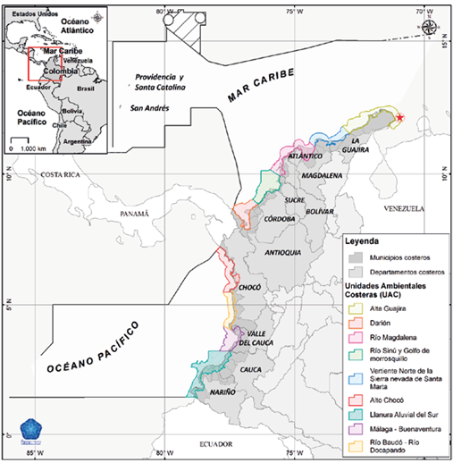
Colombia, located in the extreme northwest of South America, has a total area of approximately 2,070,408 km2 of which 1,178,396 km2 correspond to emerged, continental, and insular lands (MMA, 2001). Its continental and insular coastal zone has an approximate area of 16,128 km2 that longitudinally includes 3,532 km of coast on the Pacific Ocean and the Caribbean Sea and 892,102 km2 of jurisdiccional waters. The territory is composed of 10 Coastal Environmental Units (UAC), which integrate 12 deparments and 60 coastal municipalities (INVEMAR-IDEAM, 2017) (map with UAC, deparments, and 60 coastal municipalities) (Figure 1).
METHODOLOGY
For this study, a methodological approach was taken to the proposals of the IPCC. The focus is on risk based on the integration of three main elements: vulnerability, exposure, and hazards (IPCC, 2014). This methodology was adapted for the TCNCC and developed in a joint project with IDEAM; the marine-coastal component being a contribution to the vulnerability analysis at municipal level throughout the Colombian territory.
This work integrates the analysis of socioeconomic data from 60 coastal municipalities in Colombia (scale 1:100,000), which were contrasted with the threats of SLR and coastal erosion, in order to estimate the impacts for the years 2040, 2070, and 2100. Official sources of information were selected given that they are kept updated, permanently available, and can be used to replicate the exercise in the future. The analysis was grouped into three dimensions: food security, human habitat, and infrastructure. For each dimensión, threat, sensitivity, and adaptive capacity matrices were applied.
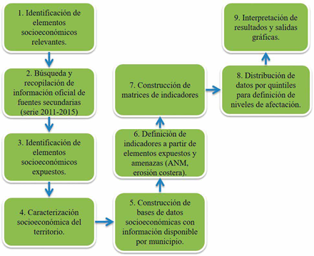
Figure 2 Methodological framework for the construction and analysis of socioeconomic vulnerability indicators.
According to the methodological scheme, the first step is the identification of relevant socioeconomic elements, for which a bibliographic review was performed to determine which demographic, economic and infrastructure characteristics and features relating to living conditions were most representative in the study municipalities. The second step involved the search for and compilation of official information from secondary sources in a time series between 2011 -2015. Here we identified the country' s official institutions such as the National Administrative Department of Statistics (DAÑE), the Ministry of Transportation, the Ministry of Health and Social Protection, the National Planning Department (DNP), the Marine and Coastal Research Institute (INVEMAR); the different departmental and municipal development plans; and the type of information they genérate, from which the data used were obtained. The time frame was defined in order to observe the changes between the Second National Communication on Climate Change (2010) and up until 2015, when the updating of the vulnerability analysis in the TCNCC began.
For the third step, the socioeconomic elements exposed were identified from a review of national and international antecedents related to climate change studies and scientific literature on how each component of the coastal zone is impacted. This led to a socioeconomic characterization (fourth step), in order to integrate all the information obtained and to have a complete vision of the territory. In the fifth step, databases were organized by variables (number of inhabitants, number of dwellings, size of municipal areas, agricultural uses, tourist uses, coastal infrastructure, among others) for each municipality, using the Excel program.
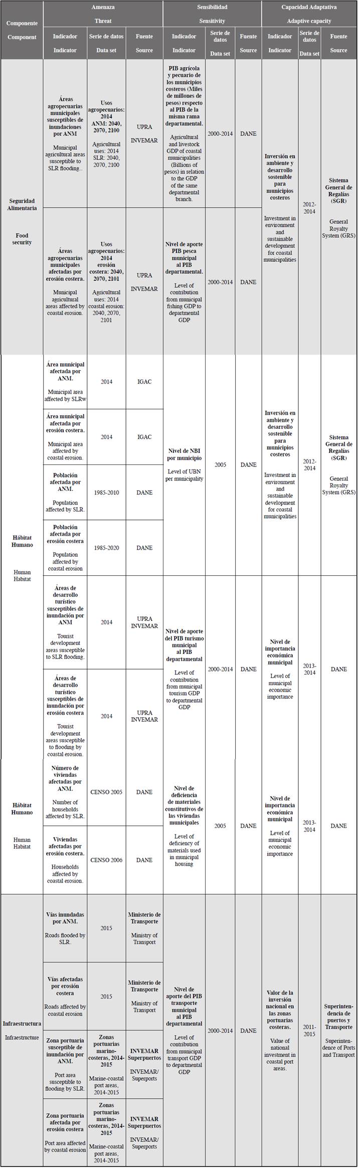
The indicators were then defined (step six) by leaving only the variables corresponding to the exposed elements in the databases. At this point, the information from the SLR flood and coastal erosion models elaborated by Invemar (2017) was used for Colombia's marine-coastal zone, where the areas affected by these threats were reported at municipal level, projected to 2040, 2070, and 2100 (INVEMAR-IDEAM, 2017). In the seventh step, these indicators were grouped in Excel tables (matrices) by the three dimensions (food security, human habitat, and infrastructure). Each socioeconomic variable was crossed with the affected areas to obtain the threat indicators. The sensitivity is observed in the intrinsic characteristics of the populations, for which the data for the percentage of Unsatisfied Basic Needs (UBN), Gross Domestic Product (GDP) and housing deficiency were used. Finally, the adaptive capacity was calculated using data relating to economic investment made in environmental issues where climate change is included by municipality (Table 1).
Table 1 Socioeconomic indicators for the analysis of vulnerability to climate change in Colombia’s coastal and insular zones.
The following formulas were used to calculate the percentage of areas affected (municipal, agricultural, tourist, and port areas):
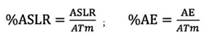
Where %ASLR and %AE, are the percentages of areas affected by SLR and coastal erosion; ASLR and AE correspond to the areas potentially floodable and lost by both threats, and ATm is the total size of each area.
The following formulas were used to calculate the population, dwellings and roads affected in each of the cases:
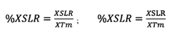
Where %XSLR and %XAE, are the percentages of affectation of the three variables due to SLR and coastal erosion; XSLR and XE correspond to the number of inhabitants, dwellings and roads located in areas susceptible to flooding and loss by both hazards, and XTm is the total size of each variable per municipality.
Once the data on affectations were obtained, the results were distributed by quintiles in each matrix, which allowed us to obtain five ranges equivalent to the levels of affectation for each indicator (very low, low, medium, high and very high). The quintiles were obtained by organizing the data from lowest to highest and dividing them into five equal parts (Vargas, 1995; Benjumea et al., 2006); in Excel, the formula "PERCENTIL.INC" was used to perform the calculation.
Affectations were estimated for 2040, 2070, and 2100, according to the availability of data, and the greatest impacts are exposed as projected for the end of the century. In this respect, the work was based on the assumption that the variables will remain constant over time, since there is no official information available projected for these years. The number of inhabitants is the only variable estimated by DANE for 2020 (based on the 2005 population census), but it does not go beyond this, since there is a high probability of obtaining erroneous estimates. Finally, the data were analyzed and interpretative graphs were drawn up.
RESULTS
The socioeconomic impacts of climate change in the country's coastal municipalities were identified using a vulnerability analysis for the Colombian coastal zone, which served as an input to complement the Third National Communication on Climate Change (2017). Twenty-three indicators related to exposure (14), sensitivity (6) and adaptive capacity (3) were used within the dimensions of food security, human habitat, and infrastructure. Also, future scenarios were developed, projecting the impacts caused by SLR and coastal erosion threats on socioeconomic variables for 2040, 2070, and 2100.
The results are presented according to threat, sensitivity, and adaptive capacity indicators respectively. For the former, the study presents the effects of SLR (Figure 3 and Figure 4) and coastal erosion (Figure 5 and Figure 6); for the sensitivity indicators, the intrinsic socioeconomic conditions of the study municipalities; and for the adaptive capacity, the levels of municipal productivity and the possibility that they have of investing to deal with climate change.
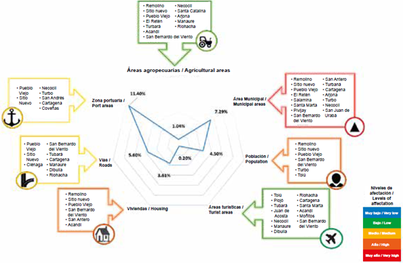
Figure 3 Levels of municipal affectation by SLR to the year 2100 for socioeconomic indicators in the Caribbean region.
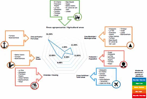
Figure 4 Levels of municipal affectation by SLR to the year 2100 for socioeconomic indicators in the Pacific region
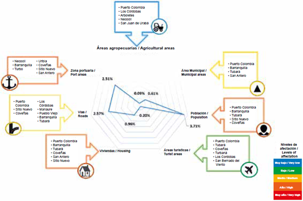
Figure 5 Levels of municipal affectation by coastal erosion by year 2100 for socioeconomic indicators in the Caribbean region.
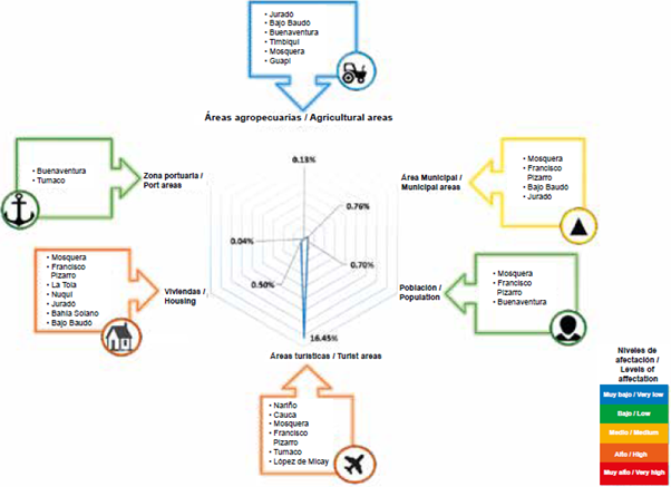
Figure 6 Levels of municipal affectation by coastal erosion by year 2100 for socioeconomic indicators in the Pacific region.
Thus, the results indicated that the municipalities belonging to Colombia’s coastal zone will suffer the impacts of climate change due to threats of SLR and coastal erosion. The maximum effects will occur around 2100, when the greatest increase in sea level -of 40 cm- is expected.
Threat indicators
Threat indicators for the human habitats dimension show that by 2100, 9% of municipal areas will be flooded; i.e., close to 640,000 hectares, which will affect 5% of the population and 4.3% of the total houses located in this area. The municipalities of the Pacific region show very high levels of affectation, with Guapi, Mosquera (Cauca) and La Tola (Nariño) being the most affected. In the Caribbean region, these levels are high, mainly in the municipalities of Remolino, Sitio Nuevo and Pueblo Viejo (Madalena). On the other hand, coastal erosion will have negative effects on about 3.4% of the total coastal population, especially in the Caribbean region with 3.71% (high level of affectation) and 0.89% of housing in both regions (high level). Likewise, tourism will suffer losses in the areas where this activity is developed of 0.27% by SLR and 13% by coastal erosion, where the Pacific region stands out with 16.4% loss by the latter.
In the dimension of food security, the implications for agricultural activity involve floods that are expected in 1.2% of the areas destined for this use due to SLR and losses of 0.11% due to coastal erosion, with low levels of affectation.
Road and port infrastructure will also suffer damage, with 5.95% of the total port area and 12.4% of the total number of highways subject to flooding mainly affecting the ports of Tumaco and Buenaventura in the Pacific region (high level) and roads in the municipalities of Pueblo Viejo, Sitio Nuevo and Ciénaga mainly (medium level). While coastal erosion will lead to the loss of 2.4% of the port areas and 2.57% of the roads, for the Caribbean, the level of affectation is high, especially in the port areas of Necoclí, Turbo (Antioquia), and Barranquilla.
Sensitivity indicators
In the human habitat dimension, poverty was measured through the Unsatisfied Basic Needs (UBN) indicator, resulting in 44% of coastal municipalities being in a critical level of deprivation. The total of municipalities presents a UBN of 78%, with the following outstanding figures: Uribia in La Guajira (96.0%), La Tola in Nariño (91.5%), Guapi in Cauca (87.4%), and Juradó in Chocó (86.2%). In turn, the housing deficiency indicates that 44 of the 60 municipalities have deficits in building materials, with Mosquera (94%), El Charco (91%) and Olaya Herrera (90%) in Nariño being the most significant. It is also estimated that 24 of the 60 coastal municipalities account for 93.8% of tourism GDP, with Cartagena, Barranquilla, Santa Marta and San Andrés as the outstanding municipalities.
In terms of food security, the agricultural branch concentrates 12 municipalities with high economic dependence on this activity, as between them they contribute about 63% of this GDP, with Buenaventura (Valle del Cauca), Tumaco (Nariño) and Pivijay (Magdalena) standing out. On the other hand, 17 municipalities concentrate approximately 92% of the fishing GDP, with Buenaventura, Tumaco and Cartagena (Bolívar) appearing again. For the infrastructure dimension on the other hand, it was found that in the transport branch 12 municipalities contribute 96% to this GDP, highlighting Barranquilla, Cartagena, Soledad and Santa Marta.
Adaptive capacity indicators
In the human habitat dimension, the Municipal Economic Importance indicator (DANE, 2012) shows that 28% of coastal municipalities present very high and high levels of importance, with Barranquilla and Cartagena standing out, while 65% of them are at low levels of importance (Figure 7). The investment in environment and sustainable development made through the General System of Royalties (SGR) indicates that 40 of the 60 municipalities of study do not report investment in this sector; 3.6% of the budget is allocated at national level to this item. The coastal zone perceives 26% of the resources, of which the Caribbean region accounted for almost all (99%), while the Pacific region participated with 0.17% (Figure 8).
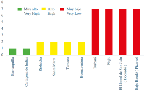
Figure 7 Coastal municipalities with higher and lower levels of economic importance (EI) (Higher EI = lower sensitivity; Lower EI = higher sensitivity).
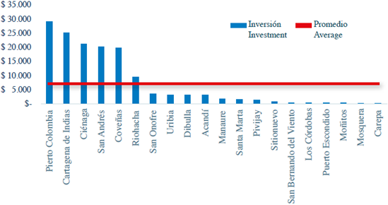
Figure 8 Investment in environment and municipal sustainable development vs. municipal average in billions of pesos.
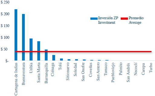
Port activity in Colombia presents investments in maintenance and in the infrastructure of the port areas. The highest levels of investment are found in Cartagena, Buenaventura, Uribia and Santa Marta, located in a range between of US$ 55,000 and US$ 220,000 million per year (Figure 9)
DISCUSSION
In terms of infrastructure, a possible affectation of 5.9% of the total maritime port zones is highlighted due to floods by SLR, mainly the ports of Tumaco and Buenaventura in the Pacific region. The municipal scale analysis of this work is unprecedented in Colombia's coastal marine zone, and it allowed us to determine the impacts of climate change at local level by highlighting the unique conditions of the territories. Thus, possible impacts caused by climate change were identified in the socioeconomic elements of municipalities located in the Caribbean, Pacific, and insular regions of Colombia, due to the two main threats for this zone: SLR and coastal erosion. The exercise constitutes an input for territorial planning, as well as for the formulation of comprehensive municipal plans for climate change management, in compliance with Law 1931 of 2018 "By which guidelines for climate change management are established."
The methodology used made it possible to approach and integrate the possible impacts on some social and economic elements framed in the dimensions of food security, human habitat and infrastructure and to measure the levels of threat, sensitivity and adaptive capacity in the face of climate change. With this, it was possible to obtain an overview of the local panorama in terms of the weaknesses and potentialities of the municipalities, thus offering inputs for the management of coastal climate change in the country.
The results obtained show similarities with international studies on climate change in coastal areas. The Colombian coastal municipalities showed possible impacts on human habitats especially on populations and productive activities with high economic dependence such as tourism, as estimated for Venezuela, Uruguay, and Peru (Tejeda, 2018; Nagy et al, 2019).
Results highlight the predictions on the impacts on coastal populations, indicating that by 2100, 5% of these could be affected due to floods caused by the SLR and 3.4% by coastal erosion. In this sense, even if just one person is harmed or loses his life by these threats, this should be considered as relevant. Likewise, there may be repercussions on municipalities with higher levels of poverty, such as Uribia (La Guajira), La Tola (Nariño), Guapi (Cauca) and Juradó (Chocó). This result, in turn, shows a 1% increase with respect to previous National Communications on Climate Change (IDEAM-UNDP, 2001, 2010), which may reflect differences in the refinement of the analysis at municipal level compared to previous studies carried out on a larger scale.
High levels of poverty (78% UBN) in the country's coastal municipalities, combined with low levels of municipal economic importance, could increase vulnerability to climate change (Musetta et al., 2017; Yañes-Arancibia, 2014). The fact that 60% of municipalities present low levels in terms of this last indicator reflects low economic productivity, since it represents the relative weight of the Gross Domestic Product (GDP). This implies that to adapt to climate change, municipalities should implement solutions that improve social and economic conditions and involve other complementary measures such as ecosystem-based adaptation (EbA). This is related to the use of biodiversity and ecosystem services for adaptation (Reguero et al., 2016), which has already been applied to climate adaptation plans in Europe and shows great potential in the face of the challenges of climate change (Geneletti and Zardo, 2016). Also useful is community-based adaptation (CbA) where communities are empowered with processes to reduce vulnerability and increase adaptive capacity (Galindo et al., 2017); and those useful measures according to present conditions.
The possible losses in tourist areas are important impacts, since this activity represents the vocation of many coastal municipalities such as Buenaventura (Arboleda, 2017). These impacts become relevant when considering that local economies are highly dependent on this sector and the activity is also sensitive to extreme weather events. In this sense, there are municipalities in the Pacific region that have considered tourism in their development plans and aim to increase its intensity. However, the greatest loss of tourist area due to coastal erosion is expected in this sphere (about 16%), hence, the importance of strengthening and creating adaptation alternatives specific to the sector.
In infrastructure, a possible affectation of 5.9% of the total areas of the country's maritime port zones is highlighted due to flooding by SLR, especially in the ports of Tumaco and Buenaventura in the Pacific region. This is related to the study by Reyer et al. (2015) for Latin America, which establishes that important ports such as those of Cartagena and Barranquilla could be negatively impacted by this threat, with consequences on the prices of goods traded abroad. However, to the extent that annual investments are maintained in these areas, they may be highly adaptive.
In order to improve the results obtained in this study, in the future, the databases used in the methodology could be enriched, based on the possible availability of official sources of information, which offer data at more detailed scales and diminish uncertainty in the estimates. It may be beneficial to analyze the possibility of increasing the number of indicators, in order to include other socioeconomic elements such as health, education, basic sanitation, income-generating capacities and social mobility, which account for societies' sensitivity and adaptive capacity and to identify the impacts on other economic activities present in the coastal marine zone, such as fishing and aquaculture. In turn, existing indicators could be strengthened by including specific information such as the impact on the variety of crops and hotel infrastructure.
CONCLUSIONS
This study offers an approach to the socioeconomic impacts caused by climate change in the country's coastal municipalities due to threats of SLR and coastal erosion. It offers input for territorial planning and the elaboration of climate change management plans and serves as a contribution to the coastal marine component of the Third National Communication on Climate Change (TCNCC). It made it possible to identify the threats, sensitivity and adaptive capacity of several elements relevant to the study area, allowing an approximation to the municipalities' weaknesses and possibilities in terms of adaptation to climate change.
The results obtained show similarities with other studies on the impacts of climate change on Latin America and specifically on coastal countries such as Venezuela, Uruguay and Peru, with possible effects on human habitats, mainly on populations and productive activities such as tourism.
Poverty measured through UBN, combined with low proportions of economic production (calculated through municipal economic importance), indicate high sensitivity of coastal municipalities, reflecting the need for actions that encompass social and productive management accompanied by alternatives such as ecosystem-based adaptation (EBA) and community-based adaptation (CBA). The planning of climate change management in productive activities is important, mainly those that are vocational and of high economic dependence such as tourism, given the high probability of affectation, especially in the Colombian Pacific region.
The maritime port infrastructure could be affected by SLR, causing negative impacts on much of the international trade activities. This threat must therefore be considered in port plans and as long as annual investments are maintained in these areas, they may be highly adaptive.
Climate threats affect coastal municipalities differently, which is why vulnerability and risk studies should be undertaken for each of them in order to generate adaptation measures in accordance with their characteristics and reduce the social and economic effects. This study is a contribution to the continuity of the climate change management process in Colombia, and has been used as input for the preparation of some coastal climate change plans.
Such studies need to be updated over time in order to identify the changes in the impacts and dynamics of the threats of climate change, and to foresee possible accelerations in the effects and thus apply rapid responses that prevent an increase in the possible damage.
ACKNOWELDGEMENTS
The authors would like to thank the Instituto de Investigaciones Marinas y Costeras - Invemar and the Instituto de Hidrología, Meteorología y Estudios Ambientales -IDEAM for the elaboration of the Coastal and Insular Marine Vulnerability Analysis of the Third National Communication on Climate Change for Colombia. Contribution N°1124, Invemar.
REFERENCES
Allison, E., A. Perry, M. Badjeck, W. Adger, K. Brown, D. Conway, A. Halls, G. Pilling, J. Reynolds, N. Andrew and N. Dulvy. 2009. Vulnerability of national economies to the impacts of climate change on fisheries. Fish and Fish., 10 (2): 173 - 196. https://doi.org/10.1111/j.1467-2979.2008.00310.x. [ Links ]
Arboleda, N. 2017. Lineamientos estratégicos para la gestión del turismo en el distrito de Buenaventura (Colombia). Tur. Soc., 23: 237-266. [ Links ]
Armanfar, M., H. Goharnejad, M. Niri Zakeri and W. Perrie. 2019. Assessment of coastal vulnerability in Chabahar Bay due to climate change scenarios. Oceanología. https://doi.org/10.1016/j.oceano.2019.03.001. [ Links ]
Banco Interamericano de Desarrollo - BID. 2010. Vulnerabilidad y adaptación al cambio climático Diagnóstico inicial, avances, vacíos y potenciales líneas de acción en Mesoamérica. Washington, D.C. 110 p. [ Links ]
Benjumea, J., D. Fernández, M. Márquez, J. Núñez y J. Vilches. 2006. Matemáticas avanzadas y estadística para ciencias e ingenierías. Universidad de Sevilla, Sevilla. 271 p. [ Links ]
Binita, K., M. Shepherd and C. Johnson. 2015. Climate change vulnerability assessment in Georgia. App. Geogr., 62: 62 - 74. https://doi.org/10.1016/j.apgeog.2015.04.007. [ Links ]
Camare, H. and D. Lane. 2015. Adaptation analysis for environmental change in coastal communities, Socio-Econ. Plan. Sci., 51:34-45. [ Links ]
Da Cruz, G. 2009. Cambio climático y turismo posibles consecuencias en los destinos turísticos de Bahía - Brasil. Est. Persp. Tur., 18(4): 476 - 489. [ Links ]
Day, J., A. Yáñez-Arancibia y J. Rybczyk. 2011. Cambio climático: efectos, causas, consecuencias: cambios físicos, hidromorfológicos, ecofisiológicos y biogeográficos. Módulo Referencia Sistemas Terrestres y Ciencias Ambientales. Trat. Estuario Cienc. Cost., 8: 303-315. https://doi.org/10.1016/B978-0-12-374711-2.00815-9. [ Links ]
Departamento Administrativo Nacional de Estadística - DANE. 2012. Indicador de importancia económica municipal, Cuentas nacionales departamentales, Indicador de importancia económica municipal, Cuentas nacionales departamentales, https://www.dane.gov.co/index.php/estadisticas-por-tema/cuentas-nacionales/cuentas-nacionales-departamentales/indicador-de-importancia-economica-municipal. 15/10/2016. [ Links ]
Diez, J. 2000. A review of some concepts involved in the sea-level rise problem. J. Coast. Res., 16(4):1179-1184. [ Links ]
Ding, Q., C. Xinjun, R. Hilborn and Y. Chen. 2017. Vulnerability to impacts of climate change on marine fisheries and food security. Mar. Pol., 83: 55 - 61. Doi: 10.1016/j.marpol.2017.05.011. [ Links ]
Galindo, A., J. Pérez y R. Rojano. 2017. Medidas de adaptación al cambio climático en una comunidad indígena del norte de Colombia. Rev. U.D.C.A. Act. Div. Cient., 20(1): 187 - 197. [ Links ]
Gallopin, G. 2006. Linkages between vulnerability, resilience, and adaptive capacity. Global Environ. Change, 16 (3): 293-303. https://doi.org/10.1016/j.gloenvcha.2006.02.004. [ Links ]
Geneletti, D. and L. Zardo. 2016. Ecosystem-based adaptation in cities: An analysis of European urban climate adaptation plans. Land Use Pol., 50: 38-47. https://doi.org/10.1016/j.landusepol.2015.09.003. [ Links ]
Giménez, A. y B. Lanfranco. 2012. Adaptación al cambio climático y la variabilidad: algunas opciones de respuesta para la producción agrícola en Uruguay. Rev. Mex. Cienc. Agr., 3(3):611-620. [ Links ]
IDEAM - PNUD. 2001. Primera comunicación nacional ante la Convención Marco de las Naciones Unidas sobre el Cambio Climático. Bogotá. 267 p. [ Links ]
IDEAM - PNUD. 2010. Segunda comunicación nacional ante la Convención Marco de las Naciones Unidas sobre Cambio Climático. Bogotá. 440 p. [ Links ]
IDEAM, PNUD, MADS, DNP y CANCILLERIA. 2017. Tercera comunicación nacional de Colombia a la Convención Marco de las Naciones Unidas sobre Cambio Climático (CMNUCC). IDEAM, PNUD, MADS, DNP, CANCILLERÍA, FMAM. Bogotá D.C. [ Links ]
INVEMAR - IDEAM. 2017. Elaboración del análisis de vulnerabilidad marino costero e insular ante el cambio climático para el país. Inf. Técn. Final (ITF) - 001. Contrato con el Programa de las Naciones Unidas para el Desarrollo - PNUD, N°. 0000040357. Santa Marta. 256 p. [ Links ]
Intergovernmental Panel on Climate Change - IPCC. 1995. IPCC Second Assessment Climate Change 1995. Contribution of Working Groups I, II and III to the Second Assessment Report of the Intergovernmental Panel on Climate Change. Cambridge University Press, New York. 73 p. [ Links ]
Intergovernmental Panel on Climate Change - IPCC. 2014. Climate Change 2014: Impacts, Adaptation, and Vulnerability. Part A: Global and Sectoral Aspects. Contribution of Working Group II to the Fifth Assessment Report of the Intergovernmental Panel on Climate Change. Cambridge University Press, Cambridge, United Kingdom and New York. 1132 p. [ Links ]
Klein, R., R. Nicholls, S. Ragoonaden, M. Capobianco, J. Aston and E. Buckley. 2001. Technological options for adaptation to climate change in coast. J. Coast. Res ., 17(3): 531-543. [ Links ]
Kokot, R., J. Codignotto y M. Elissondo. 2004. Vulnerabilidad al ascenso del nivel del mar en la costa de la provincia de Río Negro. Rev. Asoc. Geol. Arg., 59(3): 477-487. [ Links ]
Kuok Ho, D. 2019. Climate change in Malaysia: Trends, contributors, impacts, mitigation and adaptations. Sci. Total Environ., 650(2):1858-1871. https://doi.org/10.1016/j.scitotenv.2018.09.316. [ Links ]
Lampis, X. 2013. Vulnerabilidad y adaptación al cambio climático: Debates acerca del concepto de vulnerabilidad y su medición. Cuad. Geogr., Rev. Col. Geogr., 22(2): 17-33. [ Links ]
Ministerio del Medio Ambiente - MINAMBIENTE. 2001. Pronunciamiento sobre los estudios y propuestas de zonificación en áreas de manglares jurisdicción de CARSUCRE, CORALINA, CORPAMAG, CRA, CVS y CVC y, se adoptan otras determinaciones. Bogotá. 45 p. [ Links ]
Mussetta, P, M. Barrientos, E. Acevedo, S. Turbay y O. Ocampo. 2017. Vulnerabilidad al cambio climático: Dificultades en el uso de indicadores en dos cuencas de Colombia y Argentina. Rev. Metodol. Cienc. Soc., (36): 119-147. Doi/ empiria.36.2017.17862. [ Links ]
Nagy, G., O. Gutiérrez, E. Brugnoli, J. Verocai, M. Gómez-Erache, Al Villamizar, I. Olivares, U. Azeiteiro, W. Leal and N. Amaro. 2019. Climate vulnerability, impacts and adaptation in Central and South America coastal areas. Reg. Stud. Mar. Sci., https://doi.org/10.1016/j.rsma.2019.100683. [ Links ]
Olivo, M., E. Lettherny, C. Platt y M. Sosa. 2001. Pérdidas de tierra en la costa venezolana debido al incremento del nivel del mar. Interciencia, 26(10): 463-468. [ Links ]
Olivo-Garrido, M., V. Sáez-Sáez, A. Martín-Zazo y A. Soto-Olivo. 2012. Vulnerabilidad al incremento del nivel del mar: estrategias de adaptación en el área Cabo Codera-Laguna de Tacarigua, estado Miranda, Venezuela. Terra Nueva Etapa, 28(43): 45-70. [ Links ]
Panel Intergubernamental de Cambio Climático - IPCC. 1990. Resuman General Primer Informe de Evaluación del IPCC. Contribución de los Grupos de Trabajo I, II, y III al Primer Informe de Evaluación del Grupo Intergubernamental de Expertos sobre el Cambio Climático, Ginebra. 14 p. [ Links ]
Panel Intergubernamental de Cambio Climático - IPCC. 2001. Cambio climático 2001: Informe de síntesis, contribución de los Grupos de Trabajo I, II, y III al Tercer Informe de Evaluación del Grupo Intergubernamental de Expertos sobre el Cambio Climático, IPCC, Ginebra. 172 p. [ Links ]
Panel Intergubernamental de Cambio Climático - IPCC. 2007. Contribución de los Grupos de Trabajo I, II y III al Cuarto Informe de Evaluación del Panel Intergubernamental sobre el Cambio Climático, IPCC, Ginebra. 104 p. [ Links ]
Petzold, J. and R. Beate. 2015. Climate change adaptation under a social capital approach e ananalytical framework for small islands. Ocean Coast. Manag., 112:36-43. [ Links ]
Ramos-Reyes, R., J. Zavala-Cruz, L. Gama-Campillo, D. Pech-Pool y M. Ortiz-Pérez. 2016. Indicadores geomorfológicos para evaluar la vulnerabilidad por inundación ante el ascenso del nivel del mar debido al cambio climático en la costa de Tabasco y Campeche, México. Bol. Soc. Geol. Mex., 68(3): 581-598. Doi: 10.18268/BSGM2016v68n3a12. [ Links ]
Reguero, B., M. Beck, I. Losada y S. Narayan. 2016. Uniendo ingeniería y ecología: la protección costera basada en ecosistemas. Ribagua - Rev. Iberoam. Agua. Doi: 10.1016/j.riba.2016.06.002. [ Links ]
Reyer, C., S. Adams, T. Albrecht, F. Baarsch, A. Boit, N. Canales, M. Cartsburg, D. Coumou, A. Eden, F. Fernandes, F. Langerwisch, R. Marcus, M. Mengel, D. Mira-Salama, M. Perette, P. Pereznieto, A. Rammig, J. Reinhardt, A. Robinson, M. Rocha, B. Sakschewski, M. Schaeffer, C. Schleussner, O. Serdeczny and K. Thonicke. 2015. Climate change impacts in Latin America and the Caribbean and their implications for development. Internat. Bank Reconstr. Devel./The World Bank. DOI 10.1007/s10113-015-0854-6. [ Links ]
Slangen, A., J. Church, X. Zhang and D. Monselesan. 2014. Detection and attribution of global mean thermosteric sea level change. Geophys. Res. Lett., 41: 5951-5959. https://doi.org/10.1002/2014GL061356. [ Links ]
Tejeda, R. 2018. Sectores costeros más vulnerables entre Lurín y Pucusana ante un posible aumento del nivel del mar como consecuencia del cambio climático: adaptación y aplicación del índice de vulnerabilidad costera de Gornitz (1991). Esp. Des., 31: 59-86. https://doi.org/10.18800/espacioydesarrollo.201801.003. [ Links ]
Tragaki, A., C. Gallousi and . Karymbalis. 2018. Coastal hazard vulnerability assessment based on geomorphic, oceanographic and demographic parameters: The case of the Peloponnese (southern Greece). Land, 7 (2): 56. Doi:10.3390/land7020056. [ Links ]
Vargas A. 1995. Estadística descriptiva e inferencial. Universidad de Castilla-La Mancha. Ciudad Real, España. 577 p. [ Links ]
Vides, M. y P. Sierra-Correa. 2014. Análisis de normativa ambiental y mapeo institucional: hacia una política climática integrada para reducir el riesgo asociado al aumento en el nivel del mar en el Caribe colombiano. Bol. Invest. Mar. Cost.,43(2): 307-328. [ Links ]
Yáñez-Arancibia, A., J. Day, R. Twilley y R. Day. 2014. Manglares frente al cambio climático, ¿tropicalización global del Golfo de México? Mad. Bosq., 20 (3): 39-75. [ Links ]
Wong, P., I. Losada , J. Gattuso, J. Hinkel, A. Khattabi, K. McInnes, Y. Saito y A. Sallenger. 2014. Cambio climático 2014: impactos, adaptación y vulnerabilidad. Parte A: Aspectos globales y sectoriales. Sistemas costeros y áreas bajas. Contrib. Grupo Trab. II Quinto Inf. Eval. Panel Intergubern. Cambio Clim. 361-409. [ Links ]
Received: December 05, 2018; Accepted: June 04, 2019
 Este es un artículo publicado en acceso abierto bajo una licencia Creative Commons
