




 text in
  English (pdf)
 Article in xml format
 Article references
 Automatic translation
 Send this article by e-mail
 Cited by SciELO
  Cited by Google
  Similars in
SciELO
Similars in
SciELO  Similars in Google
 Permalink

Seagrasses are submerged and rooted angiosperms that inhabit shallow marine and estuarine environments. Globally, approximately 72 species have been recorded, forming essential habitats that support primary and secondary productivity, blue carbon sequestration, and other ecosystem services (Short et al., 2011; do Amaral Camara Lima et al., 2023). However, these communities are experiencing a decline in coverage across several regions. In Mexico, ten species of seagrasses have been documented, six of which occur at various locations along the Pacific coast: Ruppia maritima, Zostera marina, Phyllospadix scouleri, Phyllospadix torreyi, Halophila decipiens, and Halodule wrightii. Most research, however, has focused on the temperate northern region of the country, particularly in Baja California and the Gulf of California (McMillan and Phillips, 1979; Aguilar Rosas and López Ruelas, 1985; Ramírez-García and Lot, 1994; Riosmena-Rodríguez and Sánchez-Lizaso, 1996; Ramírez-García et al., 2002; Santa María-Gallegos et al., 2006; Pérez-Estrada et al., 2021).
South of the Gulf of California, knowledge about the presence and ecology of seagrasses is limited. In the Tropical Eastern Pacific, historical records of H. wrightii have been documented in several localities in southern Mexico, El Salvador, Nicaragua, Costa Rica, and Panama (Green and Short, 2003; Ramírez et al., 2017; Samper-Villarreal et al., 2018; UNEP-WCMC and Short, 2021; Samper-Villarreal, 2024), although many of these lack recent verification or herbarium specimens. For the southern Mexican Pacific, the World Atlas of Seagrasses (Green and Short, 2003) mentions two historical records in the state of Chiapas: the Mar Muerto coastal lagoon and the Soconusco coast. However, to date, there were no known studies confirming their current presence in the region.
In April 2022, during a study on the biology of the bivalve Larkinia grandis in the Mar Muerto lagoon in Chiapas, shoalgrass meadows (H. wrightii) were observed in shallow areas. These observations were later confirmed through the collection of botanical specimens, photographs, and data on patch coverage, shoot density, and physicochemical parameters of the sites. A total of seven localities were recorded within the lagoon, including the first confirmed record for the state of Oaxaca based on herbarium specimens. To our knowledge, these are the only physically verified records of the species over a stretch of approximately 2,900 km lacking previous documented occurrences between northwestern Mexico and Central America.
The Mar Muerto lagoon (15°58ʼ49.25’’N, 93°50ʼ05.84’’W; 16°17ʼ11.35’’N, 94°25ʼ20.82’’W) is located along the coasts of Oaxaca and Chiapas and is one of the largest coastal lagoons in the Mexican Pacific, covering approximately 720 km². At its southeastern end, it connects to the Gulf of Tehuantepec through the Boca de Tonalá inlet, which is approximately 1.3 km wide (Tapia-García et al., 2011). It is a shallow lagoon, with depths ranging from 1 to 4 meters, and a warm subhumid climate with summer rainfall, 1,095 mm of annual precipitation, and an average temperature of 28.5 °C (García, 2004). During the dry season (November to January), it can exhibit hyperhaline conditions of up to 55 psu (Romero-Berny et al., 2018).
To assess the presence of seagrasses, boat transects were conducted perpendicular to the sandbar, covering 23 km from Punta Oaxaca to Isla Pájaros (16°7’11.58”N, 94°7’45.85”W). Patch coverage was estimated using a Geographic Information System (GIS) based on georeferenced coordinates. In August and November 2023, two 50-meter transects (T1 and T2) were established in areas of differing depth (T1: 1.7-2 m; T2: 0.3-0.7 m). At each transect, temperature, salinity, and depth were measured (eight measurements per month), and seagrass samples were collected every 10m using a 15 cm PVC corer to record the number of shoots and leaf length.
In November 2023, seven botanical specimens were collected from the lagoon: five in Chiapas and two in Oaxaca (Figure 1). Identification was based on the examination of the leaf apex (Kuo and den Hartog, 2001) and the morphological variations reported for H. wrightii in Mexico (van Tussenbroek et al., 2010). The specimens were processed for herbarium preservation following Ramos-Durón et al. (2004) and deposited in the Heizi Matuda Herbarium (HEM) at the Universidad de Ciencias y Artes de Chiapas. The collection was conducted under authorization from SEMARNAT (permit No. SPARN/DGVS/09897/24).
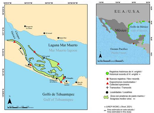
Figure 1 The right panel shows the distribution of Halodule wrightii in Mexico and neighboring countries (green circles), based on historical records (UNEP-WCMC and Short, 2021), as well as the site with new records in the southern Mexican Pacific (red star). The left panel shows the localities (black circles), specimen collection sites (red triangles), transects (crosses), and areas with H. wrightii patches in the Mar Muerto coastal lagoon, Mexico, during 2023
Halodule wrightii Asch., in Sitzungsber. Ges. Naturf. Freunde Berlin 1868: 19 (Ascherson, 1869).
Type specimen. CUBA-Without data, 1865, Wright 84 (holotype: B destroyed). Neotype: CUBA- Without data, Wright 3720 (neotype: K; isoneotypes: C, GH, US). Neotypified in Blumea 12: 305 (den Hartog, 1964).
Examined material. MEXICO-Chiapas • Municipality of Tonalá, Ranchito de La Barra, Mar Muerto lagoon; 15°59ʼ38.76ʼʼN, 93°58ʼ10.20ʼʼW; 29.IX.2023; ME Hernández Cueva leg, (HEM 37813). • ibid.; 15°59ʼ38.76ʼʼN, 93°58ʼ10.20ʼʼW; 29.IX.2023; ME Hernández Cueva leg, (HEM 37814). • Municipality of Tonalá, Isla El Manglito, Mar Muerto lagoon; 16°0ʼ13.38ʼʼN, 93°57ʼ46.50ʼʼW; 29.IX.2023; ME Hernández Cueva leg, (HEM 37815). • Municipality of Tonalá, El Conchal-Punta Este, Mar Muerto lagoon; 16°2ʼ18.18ʼʼN, 93°58ʼ34.20ʼʼW; 29.IX.2023; ME Hernández Cueva leg, (HEM 37816). • Municipality of Tonalá, El Conchal-Punta Oeste, Mar Muerto lagoon; 16°4ʼ4.14ʼʼN, 94°2ʼ4.50ʼʼW; 29.IX.2023; ME Hernández Cueva leg, (HEM 37817). • MEXICO-Oaxaca • Municipality of San Francisco Ixhuatán, Cachimbo, Mar Muerto lagoon; 16°1ʼ58.63ʼʼN, 94°2ʼ45.13ʼʼW; 29.IX.2023; ME Hernández Cueva leg, (HEM 37818). • Municipality of San Francisco Ixhuatán, Canal de La Majada, Mar Muerto lagoon; 16°5ʼ45.19ʼʼN, 94°5ʼ53.79ʼʼW; 30.IX.2023; ME Hernández Cueva leg, (HEM 37819).
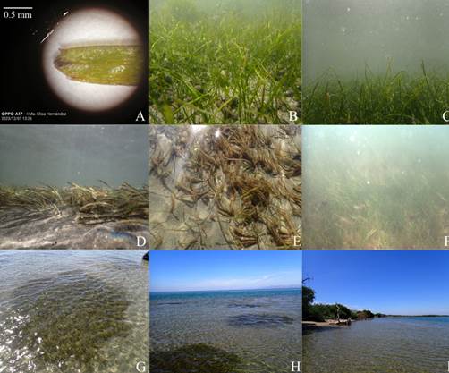
Figure 2 Halodule wrightii from the Mar Muerto coastal lagoon, Mexico. A. Close up of the leaf tip. B. Meadow at El Ranchito de La Barra, Tonalá, Chiapas (HEM 37813). C. Meadow at Transect 1. D. Meadow at Transect 2. E. Meadow at Isla El Manglito, Tonalá, Chiapas (HEM 37815). F. Meadow at Cachimbo, San Francisco Ixhuatán, Oaxaca (HEM 37818). G-H. Seagrass patches. I. Habitat.
Identification. Creeping rhizomes with 2 to 5 roots and a short, erect stem per node; internodes 0.7 to 3.5 cm long; leaves 6 to 20 cm long, with a coloration ranging from green to light or dark reddish-brown; sheaths 1.5 to 4 cm long and 1 to 1.5 mm wide; blades 5 to 18 cm long and 0.5 to 1 mm wide, tapering at the base. The midrib is emarginate, sometimes ending in a small, fragile, non-prominent tooth; lateral intramarginal veins are inconspicuous, both terminating in a narrow, triangular lateral tooth; apex obtuse, usually bicuspidate, with the area between the lateral teeth being slightly concave. Flowers and fruits were not observed.
Ecology and habitat. An area of 17.7 km² (approximately 2.46% of the lagoon’s total area) in the southeastern region of the Mar Muerto lagoon contains patches of H. wrightii of varying extent (Figure 1). Based on the assessment conducted along both transects, the average leaf length was 10.32 ± 1.26 cm (T1: 10.93 ± 0.69 cm; T2: 9.72 ± 1.48 cm), while the average total shoot density was 1,724 ± 782.1 shoots m-². Salinity and water temperature exhibited low variability across transects and months, with average values of 33.06 ± 3.5 psu and 31.4 ± 0.8°C, respectively. The shallowest depth recorded was 0.13 m (Isla El Manglito), while the greatest depth was 2.1 m in T2, recording an average value of 1.1±0.8 m.
Conservation. Currently, the species is classified as “Least Concern” by the IUCN (Short et al., 2010). In Mexico, it is listed as “Threatened” under the federal law NOM-059-SEMARNAT-2010 (SEMARNAT, 2010), but only in certain regions of the states of Veracruz and Sonora (SEMARNAT, 2019). Locally, the shoalgrass areas in the Mar Muerto lagoon are part of Ramsar site 1823, known as “Sistema Estuarino Puerto Arista” (RSIS, 2008).
The observations presented here confirm the southernmost record of H. wrightii along the Mexican Pacific and represent the first verified record for the state of Oaxaca (localities of Cachimbo and Canal de La Majada), supported by herbarium specimens and ecological data. This information complements the known distribution of seagrasses in the Tropical Eastern Pacific, where records remain scarce and discontinuous (Samper-Villarreal, 2024). In this region, seagrass detection is limited by a narrow continental shelf, greater tidal range, and high turbidity. The collected specimens exhibited apices with a medium-sized obtuse tooth, a variable morphological trait that distinguishes H. wrightii from Halodule beaudettei, although both have been proposed as potential synonyms. The mean salinity recorded (33.06) falls within the range reported for the species in the Eastern Pacific, as does the average temperature (31.4 °C), which is relatively high but still suitable for leaf production. Shallow conditions favor the development of short, narrow leaves (~10 cm), although in some locations the meadows may become exposed during low tide. Temporal variations in their extent were observed, possibly related to seasonal hydrological changes. Due to its environmental tolerance and dispersal capacity, H. wrightii plays a key role in habitat structure, geomorphic stability, and the regulation of sediment and nutrient flows. Although most of the meadows documented here are located within Ramsar site 1823, conservation measures are recommended to ensure the continuity of ecological processes and ecosystem services provided by this intertidal vegetation.

