


Services on Demand
Journal
Article
 English (pdf)
 Article in xml format
 Article references
 Send this article by e-mail
Indicators
-
 Cited by SciELO
 -
 Access statistics
Related links
-
 Cited by Google
 -
 Similars in
SciELO
Similars in
SciELO -
 Similars in Google
Share

 Permalink
Earth Sciences Research Journal
Print version ISSN 1794-6190
Earth Sci. Res. J. vol.13 no.1 Bogotá Jan./June 2009
COMPARATIVE EVALUATION OF THE INFLUENCING EFFECTS OF GEOMAGNETIC SOLAR STORMS ON EARTHQUAKES IN ANATOLIAN PENINSULA
Sadik Cengiz Yesugey
Dokuz Eylul University, Faculty of Architecture, Campus of Tinaztepe, Dogus Str. No.209 Kurucesme, Buca, Yzmir Turkey. Phone: +902324535716 Fax: +902324532986
Corresponding author Email: cengiz.yesugey@deu.edu.tr
Manuscript receiver: December 12th, 2008. Accepted for publication: July 28th, 2009.
ABSTRACT
Earthquakes are tectonic events that take place within the fractures of the earth's crust, namely faults. Above certain scale, earthquakes can result in widespread fatalities and substantial financial loss. In addition to the movement of tectonic plates relative to each other, it is widely discussed that there are other external influences originate outside earth that can trigger earthquakes. These influences are called "triggering effects". The purpose of this article is to present a statistical view to elaborate if the solar geomagnetic storms trigger earthquakes. As a model, the research focuses on the Anatolian peninsula, presenting 41 years of historical data on magnetic storms and earthquakes collated from national and international resources. As a result of the comparative assessment of the data, it is concluded that the geomagnetic storms do not trigger earthquakes.
Keywords: Earthquake, Earthquake triggering, geomagnetic storms.
RESUMEN
Los terremotos son eventos tectónicos que tienen lugar dentro de las fracturas de la corteza terrestre, nominalmente las fallas. Por encima de cierta escala los terremotos pueden resultar considerables pérdidas humanas y financieras. Adicionalmente de los movimientos de las placas tectónicas, es ampliamente discutido que hay otras influencias originadas en el exterior de la tierra que pueden desencadenar terremotos. Estas influencias son llamadas "Efectos disparados". El propósito de este artículo es presentar una observación estadística sobre si las tormentas solares geomagnéticas desencadenan terremotos. Como un modelo, la investigación se centra sobre la península Anatolia, presentando 41 años de datos históricos sobre tormentas magnéticas y terremotos cotejados con datos nacionales e internacionales. Como resultado de la evaluación comparativa de los datos, esto esta concluyendo que las tormentas geomagnéticas no desencadenan terremotos.
Palabras Claves: Terremoto, desencadenar Terremoto, tormentas geomagnéticas
1. Introduction
Earthquakes are tectonic events that take place within the fractures of the earth's crust, namely faults. In addition to the movement of tectonic plates relative to each other, it is widely discussed that there are other external influences originate outside earth that can trigger earthquakes. These influences are called "triggering effects". Examples of such external events are the lunar and solar eclipses, planetary alignment within the solar system and the influences ofgeomag-netic storms taking place in the sun. The most influential of these events is considered to be the extraordinary solar activities influencing the earth's geomagnetic field. Anatolian peninsula is a historically active earthquake region within the borders of Turkish Republic. The peninsula, surrounded by Black Sea in the north, Aegean Sea in the west, Mediterranean Sea in the south, lies at the intersection of Asia, Europe and Africa continents. Hundreds of earthquakes in various scales take place every year in this active region. The most recent major earthquake, Marmara Earthquake, took place on 17th August 1999 and measured 7.3 on Richter scale, causing extensive damage and widespread fatalities. The purpose of this article is to present a statistical view to elaborate if the solar geomagnetic storms trigger earthquakes. As a model, the research focuses on the Anatolian peninsula, presenting 41 years of historical data on magnetic storms and earthquakes collated from national and international resources.
2. The causes of earthquakes and geomagnetic storm and measurement methods
This section outlines the principles behind the occurrence of earthquakes and geomagnetic storms and the methods used to measure them.
2.1 The causes of earthquakes and measurements methods
In 1911, Professor Reid established the elastic-rebound theory, supported with [Reid,H.F, 1911]. A mathematical scale was required in order to obtain the data about the effects of these vibrations on the structures and Charles F. Richter and Beno Gutenberg applied "Magnitude" concept on this field in 1930 [Gutenberg, B.,et al., 1954]. Among these; Mb is calculated by taking as basis the magnitude of P and S waves (Body-wave magnitude), Md is calculated by using the durations of very small and close earthquakes, Ms is calculated by taking as basis the magnitude of surface waves (Surface-wave magnitude) and Mw takes as basis the seismic moment of the released energy (Moment magnitude). These are the most used magnitude measures. Different magnitude methods can give different values around 0.2M. This difference can reach up to 0.5M after saturation. The magnitude of an earthquake does not change wherever on earth it is measured. Giving different magnitude values of earthquakes must be associated with the method used and the fact that the geology of the place in which the recorders are located is not adequately taken into account [Gurbuz, C., 2003].
2.2 The reasons for the occurrence ofgeomagnetic storms and measurement systems
The solar material, which accelerates as a result of the energy discharges occurring in the Sun, "solar flares", "prominences" and "coronal mass ejections", reaches the Earth from the gravitational field of the Sun as different radiation forms and particles, and it interacts with the magnetic field of the Earth. In cases where these effects are dense, sudden changes occur in the magnetic field and
they create the phenomenon which is called "geomagnetic storm." Although different systems are used, one ofthe most important scales used in measuring this is the Dst "disturbance storm time" indexes which have been recorded since 1957 [Sugiura, M, 1964]. Dst index's showing high negative values means that there is a big magnetic storm [Sugiura, M, 1991]. For the magnetic fields, changes in the Dst index are evaluated in five major groups. Weak storms -30 nT>Dst >-50 nT, Moderate storms -50 nT>Dst >-100 nT, Strongstorms -100 nT>Dst>-200 nT, Intense storms -200 nT>Dst >-350 nT, Heavy storms Dst >-350 nT [Loewe, C.A., atal., 1997], [Natural Environment Research Council - British Antarctic Survey, 2001 ].
Dst values' falling to these values in their changes within 24 hours which are measured hourly is regarded as a geomagnetic storm. Within the Internet, data centers which provide service to the entire world on this subject are also concentrated in the USA. One of these institutions is the National Environmental Satellite, Data, and Information Service which operates under the USANational Oceanic and Atmospheric Administration, [National Oceanic and Atmospheric Administration (NOAA) Space Weather Prediction Center (SWPC) 2003]. Another institution is the National Geophysics Data Center where all observations on all solar activity conducted in the entire Earth, the effects of the activity on the near perimeter of the Earth and its results on the atmosphere are collected, and this center provides international data coordination, [NOOA National Geophysics Data Center, 2005]. WorldDataCenterSystemwhichis conducted by the USA National Science Foundation provides the communication between scientific research institutions all over the world. Anotherone ofthese institutions is the WorldData Center for Geomagnetism, Kyoto, Data Analysis Center for Geomagnetism and Space Magnetism Graduate School of Science, Kyoto University, [World Data Center for Geomagnetism, Kyoto, 2005].
3. The method used for the detection of the triggering effects of the earthquakes in accordance with the earthquake magnitudes and the changes in the dst values
The occurrence of the earthquakes is dependent on very different factors. Especially, the structures of the rocks are the most important features. Due to the fact that some rocks show more resistant features, they may not be broken or may be broken later than usual even though they have the same energy accumulations and they are in close regions. However, it is doubtless that they all have limit values. This can be resembled to the discharge of a condenser, which is loaded with current and which reached the limit value for the discharge, with a very low current; or overflow of a glass, which is filled with water up to its utmost capacity, with a drop of water. In this study, the breakage probabilities of the rocks, which have energy accumulation that reached up to the limit value, with geomagnetic effects apart from the other factors have been examined. The below-mentioned methods have been used in order to obtain these statistics.
3.1 Sources for the earthquake data and shortcomings
In calculating the earthquake triggering effects, the study area is limited to the Anatolian peninsula and surrounding seas, between coordinates 35°, 00'N-43°, 00'N and 25°,00'E-45°,00'E. The earthquakes which fall outside these areas are excluded from this study. The dataset used in this study is based on 41 years of data collected between 1965 and 2005. This data has been collected from the archive of the following institutions, local to the study area;
Republic Of Turkey, Ministry Of Public Works And Settlement, General Directorate Of Disaster Affairs, Earthquake Research Department, [General Directorate Of Disaster Affairs, Earthquake Research Department, 2005], Bogazici University Kandilli Observatory And Earthquake Research Institute, National Earthquake Monitoring Center -NEMC, [Bogazici University Kandilli Observatory, 2005]. The Scientific and Technological Research Council of Turkey, Marmara Research Center, Earth and Marine Sciences Institute, [The Scientific and Technological Research Council of Turkey, Marmara Research Center, 2005]. In order to ensure that the dataset is complete, the data from the above listed sources have been validated by the archives of; U.S. Geological Survey, National Earthquake Information Center USGS-NEIC, Earthquake Center, [USGS-NEIC, 2005], U.S. Geological Survey, Earthquake Hazard program, Advanced National Seismic System-ANSS,[ANSS, 2005], Incorporated Research Institutions for Seismology IRIS, [Seismology IRIS, 2005].
The data from various sources was sorted by year, month, day and coordinates, and compared with each other to identify discrepancies. In the event of discrepancies, the data from the local sources was used. During this assessment, it was identified that slight differences in coordinates could result in the same earthquake event being recorded more than once. If there are a number of earthquakes reported by various sources for the same time frame, the coordinates were compared and if the coordinates measure within ±30' (30 minutes) of each other, it was assumed that all sources record the same event, therefore, a single earthquake was included in the study. As it has been stated in Section 2.1, the measurements conducted by different institutions in different dates are archived as magnitude from time to time in accordance with Mb, Ms, Md and Mw scales, and there is no possibility to reduce them to a common unit. However, as it has been stated before, these scales take values which are very close to each other. In this condition, the values and scales provided by the Turkish institutions at the same time and date have been primarily accepted. No scale difference was inquired in the different and incomplete data that were obtained by scanning various national and international institutions, and those with the greatest magnitude values were added to the list as a data. The dataset contains all the earthquakes within the coordinate limits set for the Anatolian peninsula for the last 41 years. This data is sorted by year, month, day and magnitude. The total number of earthquake measurements within the study period is 122838. The earthquakes with magnitudes below 3.0M was excluded in order to prevent misleading results. The limiting upper bound was set to 7.9M, the highest earthquake recorded between 1965 and 2005. As widely known, there are many relatively minor preshocks leading up to the earthquake and aftershocks following the earthquake, which sometimes continue to occur for months. However, it is not practical to differentiate between the major event and its pre and after shocks. It can also be argued that geomagnetic storms could amplify the aftershocks. For this reasons, the study includes all pre shocks and aftershocks, as long as they coincide with a geomagnetic storm.
3.2 Sources for the geomagnetic storm data and shortcomings
In this study, data from World Data Center for Geomagnetism, Kyoto, Data Analysis Center for Geomagnetism and Space Magnetism Graduate School of Science, Kyoto University which are constantly and regularly broadcasted on the internet and globally acknowledged have been taken as basis [World Data Center for Geomagnetism, Kyoto, 2005]. The Dst<-30 nT value specified in Section 2.2 for the Geomagnetic storm Dst values has been accepted as the minimum storm value. With a computer program that has been prepared, 41 year old data on a 24 hour basis have been scanned, the days on which the Dst values were inside the storm limits have been listed, and the values apart from those have been marked as "0" value. Thus, "yearly and daily value" lists spanning over 41 years have been obtained.
4. Methods used in the assessment of data
The data assessment has been conducted with three different methods.
In the first method; all the earthquakes occurring in a day within the range of 3.0M-7.9M remaining within the given coordinates between the years 1965-2005 and in different regions have been collectively and on a daily basis compared with the Dst values within the same range in terms of their date, magnitude and Dst values and presented in the form of tables (For instance; each of the values with such magnitudes as 3.1M, 3.2M, 4.5M, 5.2M that occurred on the same day and within the range of 3.0-7.9 has been taken as data). Again within the same range; the earthquakes with magnitudes of 3.0M-3.9M, 4.0M-4.9M, 5.0M-5.9M, 6.0M-6.9M and 7.0M-7.9M have been compared in the form of tables and on a daily basis with the Dst values corresponding to their date and magnitude values within their own range. In this comparison, all the earthquake magnitude values within the mentioned range and occurring on the same day have been included in the comparison. (For instance; each of the values with such magnitudes as 3.1M, 3.2M, 3.5M occurring within 3.0-3.9 range and on the same day has been taken as data).
In the second method; the greatest rates of earthquakes detected within a day within the range of 3.0M-7.9M and with the magnitudes of 3.0M-3.9M, 4.0M-4.9M, 5.0M- 5.9M, 6.0M-6.9M and 7.0M-7.9M remaining within the given coordinates between the years 1965-2005 and in different regions have been within their own range collectively and daily compared with the Dst values according to their date and magnitude values and in the form of tables. However, in this comparison, among the earthquakes occurring within mentioned range and on the same day, the earthquake with the greatest magnitude detected within the day has been included in the comparison. (For instance; As far as such values as 3.1M, 4.2M, 5.5M occurring on the same day were concerned, 5.5M being the greatest value has been taken as data. Similarly, when such values as 3.1M, 3.2M, 3.5M within the range of 3.0M-3.9M occurring on the same day are concerned, only 3.5M being the greatest value has been taken as data).
In the study conducted; it has been considered that in the past years, especially the records between the 1960s and 1970s might not have been as sound as the records of our present time and as a third method, the comparisons have been repeated for the next 20 years (1986-2005).
In these comparisons made with a prepared computer program, the data and statistical values below have been obtained. The evaluation of the data was carried out using a bespoke computer model and the below listed data and statistical values have been obtained.
Input; Number of earthquakes corresponding to geomagnetic storm within the magnitude interval (M), number of earthquakes not corresponding to geomagnetic storm within the magnitude interval (N), total number of earthquakes within the magnitude interval (W), number of days without geomagnetic storms (-D-days), number of days with geomagnetic storms (+D-days), total number of days between 1965-2005 (Days), total number of days between 1986-2005 (Days1).
Output; Ratio of number of earthquakes corresponding to geomagnetic storms to total number of earthquakes within the magnitude interval (M/W %), ratio of number of earthquakes not corresponding to geomagnetic storms to total number of earthquakes within the magnitude interval (N/W %).
5. Evaluation tables
Based on the approach outlined in Section 4, the following evaluation tables were produced.
6. Results
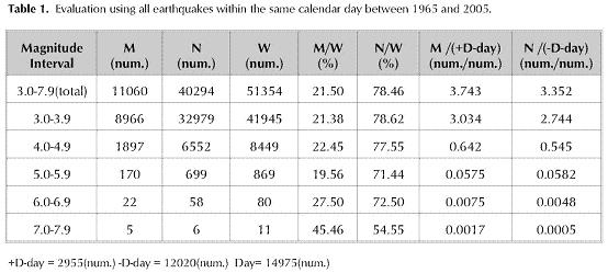
The ratio of all the earthquakes within the range of 3.0M-6.9M magnitude between the years 1965-2005 which corresponded to the days with Dst=-30nT and occurred during the day, to the number of earthquakes (W) which are within the same range differs between 19.56% and 27.50%. This ratio is 45.46% in the 7.0M-7.9M magnitude range. (Table 1).
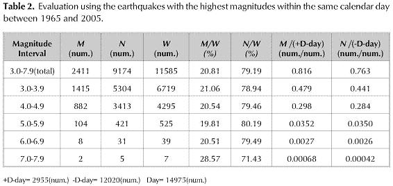
The ratio of the greatest earthquake which were detected during the day among the earthquakes between the years 1965 and 2005, and which corre-spondedto the days withDst<-30nT, to the numberof earthquakes (W) occurring within the same range differs between 19.8% and 20.8%. This ratio is 28.57% in the 7.0M-7.9M magnitude range (Table 2).
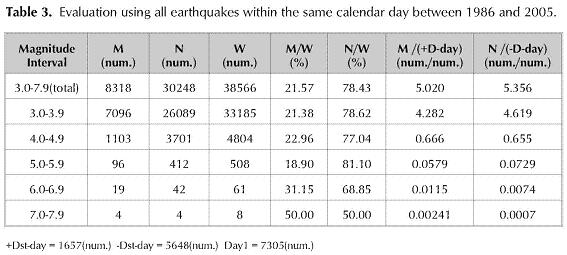
The ratio of the earthquakes within the range of 3.0M-5.9M magnitude between the years 1986-2005 corresponding to the days with Dst<-30nT and occurring during the day, to the number of earthquakes (W) which occurred within the same range differs between 18.90% and 22.96%. This ratio is 31.15% in the 6.0M-6.9M magnitude range and 50% in the 7.0M-7.9M magnitude range (Table 3).
The ratio of the greatest earthquake which was detected during the day among the earthquakes within the 3.0M-5.9M range and corresponding to the days with Dst<-30nT between the years 1986 and 2005, to the number of earthquakes (W) that occurred within the same range differs between 20.00% and 22.67%. This ratio is 23.08% in the 6.0M-6.9M magnitude range and 25.00% in the 7.0M-7.9M magnitude range (Table 4).
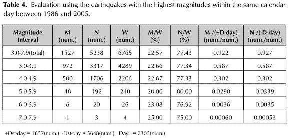
In addition, there is not a significant quantitative increase of the empirical values M/(+D-day) ratio (Table 1-4).
7. Conclusion
When the ratios above are examined and the highness of the ratio of Dst>-30nT values to total days are taken into account, both between the years 1965-2005 and 1986-2005, an extraordinary quantitative increase can not be seen in the earthquakes which have magnitudes of 3.0M-5.9M and which correspond to days with Dst>-30nT. When it is considered that the aftershocks are also included in the number of earthquakes which have been taken into the comparison, in the area within the given coordinates, there is no finding that shows that the earthquakes occur as a result of a triggering under the effect of geomagnetic storm. In order to mention such a finding, more number of earthquakes should occur with percentages that correspond to geomagnetic storms. This is not verified by the results.
Earthquakes with magnitudes of 6.9M-7.9M are very few in number. The fact that these partially have greater percentages gives the impression that they are coincidental values rather than findings that form correlation with geomagnetic storms.
As a result of all these data, a hypothesis can not be put forward which suggests that geomagnetic storms trigger earthquakes in the Anatolian peninsula. However, these results should not hinder the conduction of further research. A global study on this subject can potentially provide new approaches.
References
Gutenberg B. and Richter C. F. (1954), Seismicity of the Earth and Associated Phenomena, 2nd Edition, Princeton Univ. Pres, New Jersey. [ Links ]
Loewe C. A., Prolss, G. W. (1997), Classification and mean behaviour of magnetic storms, Journal of Geophysical Research, A 102, 14209-14213. [ Links ]
Reid, H. F., (1911), The elastic-rebound theory of earthquakes, University of California Department of Geology Bulletin, 6(19) 413-444, Berkeley. [ Links ]
Sugiura, M., (1964), Hourly values of equatorial Dst, Annals of the International Geophysical Year, vol. 35, pp. 945-948, Pergamon Press, Oxford. [ Links ]
Sugiura, M.,(1991), On Dst index, http://swdcwww.kugi.kyoto-u.ac.jp/dstdir/dst2/onDstindex.html, paper presented at IAGA Bulletin No. 40. [ Links ]
Bogazici University Kandilli Observatory And Earthquake Research Institute, (2005), Internet Site For National Earthquake Monitoring Center -NEMC, http://www.koeri.boun.edu.tr/ (last accessed 2008). [ Links ]
Gurbuz,C. (2003). Internet Site for Earthquake Magnitude, Bogazici University Kandilli Observatory And Earthquake Research Institute, National Earthquake Monitoring Center -NEMC, http://www.koeri.boun.edu.tr/jeofizik/html/info_mag-nitude.htm (last accessed October 2008). [ Links ]
Incorporated Research Institutions for Seismology, (2005), Internet Site For IRIS, http://www.iris.edu/quakes/quakes.htm (last accessed 2008). [ Links ]
Natural Environment Research Council - British Antarctic Survey (2005), Internet Site For Satellite Risk Index, http://www.antarctica.ac.uk/SatelliteRisks/dstdetails.html (last accessed 2008). [ Links ]
National Oceanic and Atmospheric Administration (NOAA) Space Weather Prediction Center (SWPC) (2005), Internet Site For ACE Real Time Solar Wind News and Announcement, http://www.swpc.noaa.gov/ace/ (last accessed March 31, 2003). [ Links ]
NOAA, National Geophysics Data Center (2005), Internet Site For Space Weather and Solar Events, http://www.ngdc.noaa.gov/ (last accessed July 30, 2008). [ Links ]
World Data Center for Geomagnetism (2005), Internet Site For Data Analysis Center for Geomagnetism and Space Magnetism Graduate School of Science, Kyoto University, http://swdcwww.kugi.kyoto-u.ac.jp/ (last accessed 2008). [ Links ]
Republic Of Turkey, Ministry Of Public Works And Settlement, General Directorate Of Disaster Affairs, (2005), Internet Site For Earthquake Research Department, http://www.deprem.gov.tr/indexen.html (last accessed 2008). [ Links ]
The Scientific and Technological Research Council of Turkey, (2005), Internet Site For Marmara Research Center, Earth and Marine Sciences Institute http://www.mam.gov.tr/eng/institutes/ydbe/(last accessed October 07, 2008). [ Links ]
U.S. Geological Survey, (2005), Internet Site For National Earthquake Information Center USGS-NEIC, http://earthquake.usgs.gov/eqcenter/(last accessed July 16, 2008). [ Links ]
U.S. Geological Survey, Earthquake Hazard program, Advanced National Seismic System, (2005), Internet Site For ANSS http://earth-quake.usgs.gov/research/monitoring/anss/ (last accessed September 10, 2008). [ Links ]

