


Services on Demand
Journal
Article
 English (pdf)
 Article in xml format
 Article references
 Send this article by e-mail
Indicators
-
 Cited by SciELO
 -
 Access statistics
Related links
-
 Cited by Google
 -
 Similars in
SciELO
Similars in
SciELO -
 Similars in Google
Share

 Permalink
DYNA
Print version ISSN 0012-7353
Dyna rev.fac.nac.minas vol.79 no.176 Medellín Nov./Dec. 2012
IMPLEMENTATION OF THE MINESIGHT® TOOLS IN THE LAS CUEVAS MINE OF VALE COAL COMPANY IN COLOMBIA
APLICACIÓN DE LAS HERRAMIENTAS DE MINESIGHT® EN LA MINA DE CARBÓN LAS CUEVAS DE VALE COLOMBIA
GIOVANNI FRANCO SEPÚLVEDA
PhD(c) in Engineering, National University of Colombia at Medellín - School of Mines - Department of Materials Engineering - Mine Planning Research Group. Medellín, Colombia. gfranco@unal.edu.co
ADRIÁN FELIPE GALLO SIERRA
Mining and Metallurgy Engineer. Researcher at the Mine Planning Research Group. National University of Colombia at Medellín. School of Mines. afgallo18@gmail.com
CRISTIAN CAMILO HENAO GÓMEZ
Student of Mining and Metallurgy Engineering. Trainee Researcher, Mine Planning Research Group. National University of Colombia at Medellín. School of Mines. cchenao@unal.edu.com
WILLY JOSÉ CORZO LINARES
Student of Mining and Metallurgy Engineering. Trainee Researcher,Mine Planning Research Group. National University of Colombia at Medellín. School of Mines. wjcorzol@unal.edu.co
Received for review April 30th, 2012, accepted August 3th, 2012, final version August, 14th, 2012
ABSTRACT: This paper presents the implementation of the MineSight® tools in a theoretical project based on the Las Cuevas mine. The project relies on conventional modeling, project configuration, deployment, drilling handling and the creation of the geological and block models that make it possible to reliably determine the exploitable mineral resources of interest. An overview of the project is presented along with a theoretical case study beginning with the generation of polygons in sections representing the seams, using the true thickness tool. After this, economic envelopes were presented using the MSOPIT and MSVALP tools, together with some coal mining requirements. Finally, operational pits were designed using the Pit Expansion tool in order to optimally exploit the site and facilitate economic balance throughout the project. Upon finishing this, the Interactive Planner (IP) tool was used to carry out short-term planning.
KEYWORDS: MineSight®, mine planning, coal, geological modeling, Open pit, mine design, Vale, Colombia
RESUMEN: Este trabajo expone la implementación de herramientas MineSight® en un proyecto hipotético que será tomado como base en la mina Las Cuevas, apoyado en la modelación convencional, configuración del proyecto, desiegues, manipulación de sondajes, la creación del modelo geológico y de bloques, que permita determinar con confianza los recursos explotables del mineral de interés. Se presentan las generalidades del proyecto seguido de un caso de estudio hipotético, que inicia con la generación de polígonos en secciones para mantos con la utilización del true thickness, seguidamente se presentan las envolventes económicas en MSOPIT y MSVAL con algunos requerimientos para la minería de carbón. Posteriormente se realizan pits operacionales utilizando la herramienta Pit Expansion tool con la cual se busca explotar el yacimiento de manera óptima y facilitar el equilibrio económico a lo largo del proyecto, en su culminación se realiza el planeamiento a corto plazo con la herramienta Interactive Planner (IP).
PALABRAS CLAVE: MineSight®; planeamiento minero; carbón; modelamiento geológico; Open pit; diseño minero; Vale; Colombia.
1. INTRODUCTION
In the context of mine planning, the search for a suitable mineral extraction methodology that is more profitable for the mining business has led to the development of practical methodologies. The goal of such methodologies is to produce models that can be adjusted to the different stages of a mining project and to any eventual changes [1, 2].
This paper's authors sought to carry out the design and planning for the Las Cuevas mine using some of the modules and tools from the MineSight® mining software.
The study of the theoretical case yielded the following results: a geological model including the various seams of the deposit, and an optimal mine sequencing. The latter was achieved using tools such as MineSight Economic Planner (MSEP) and MineSight Interactive Planner (MSIP), which produce better results if applied to coal deposits.
To perform this analysis, we first established the project's configuration, i.e. general characteristics such as location and geology. This allowed us to simulate the conditions of the theoretical case study. After this phase, the theoretical case study was created by generating the polygons in sections using the MineSight® true thickness tool. Likewise, the MSOPIT and MSVALP tools were used to present the economic envelopes along with some information requested by the company, namely the production requirements per phase and the economic pit limit found by the analysis. After this, operational pits were designed using the Pit Expansion tool to optimally exploit the site and facilitate economic balance throughout the project whilst retaining the geotechnical parameters of the company's geology department. Finally, short-term planning was carried out using the Interactive Planner (IP) tool, which allowed us to construct 2 phases by generating a polygon with half a bench to represent the solids for each extraction phase.
2. PROJECT OVERVIEW
2.1. Project Location
The Las Cuevas mine is located in the El Paso municipality of the Cesar department, in northern Colombia. Figure 1 shows the location of the El Hatillo and Las Cuevas mines.
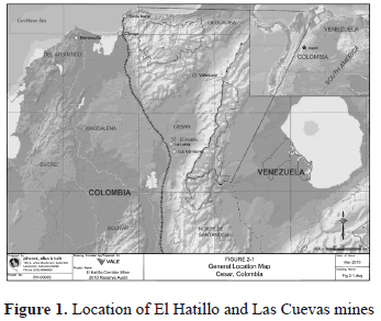
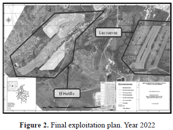
Figure 2 shows the final exploitation plan for the El Hatillo mine for 2022. It also shows the preliminary design for the Las Cuevas mine.
2.2. Geology
The plan view of the predominant structural geology of the area is shown in figure 3. Two projects can be seen: one is the El Hatillo mine, which is currently under exploitation, while the other is the Las Cuevas mine, our object of study. These seams are in a synclinal structure that is predominant in the zone. Figure 3 shows the area of the synclinal axis between the two projects.
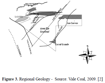
This study focuses on the Las Cuevas mine, whose deposit is crossed by the El Tigre geological fault, which separates the La Loma syncline from the Boquerón syncline. The upthrust block in the studied area is located east of the fault, whereas the dropped block is near the La Loma syncline axis. [3]
Currently, this is the only data available on the El Hatillo and Las Cuevas mines. The design and planning for the Las Cuevas mine is expected to be carried out in 2012. It is expected to be similar to the theoretical work presented in this paper.
3. CASE STUDY
A theoretical case study was created to illustrate the procedure that will be followed to model and design Vale Coal's Las Cuevas mine.
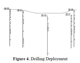
All the data required for the project was compiled, reviewed and analyzed. Upon finishing the review, geological modeling was carried out. Three basic sequential aspects that are common to all modeling processes were taken into account when creating the geological model: project configuration, drilling deployment and handling, and model creation [4]. These aspects are shown in figure 4.
- Project configuration: the project was created using the Compass GSM (Grid seam model) program with the same parameters used with the 3DBM (3D block model) program, but with a variation in the description regarding the levels (amount of seams). Additionally, spatial placement was checked using topography.
- Drilling deployment and manipulation: the procedure was not different from that of any other modeling software. Upon loading all the data into the application, the manipulation process for optimal seam deployment started (figure 4). The quality items that were taken into account were: calorific power, ash content, humidity and sulphur content.
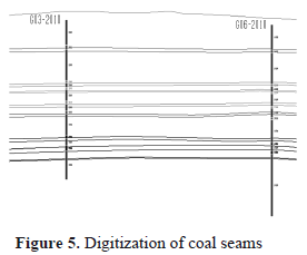
- Model creation: A semi-automatic procedure using True Thickness was carried out [5]. The traditional procedure for generating roofs and floors in coal sites was used. This procedure involves joining representative points within the drillings [6]. The procedure was carried out repetitively for each seam, and its objective was to interpolate seam roofs to generate floors or vice-versa (interpolate floors to generate roofs), as shown in figure 5.
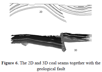
Afterwards, polygons were created in sections. These polygons had the true thickness of the seam along with its slope across the section [7]. The solids for each seam were generated using the linker tool. However, before using the true thickness tool for the seams, a fault that crosses them was digitized as shown in figure 6. This figure shows the solids of the coal seams together with the surface's topography. It also shows the fault crossing the seams and how it has displaced them. (Figure 6).
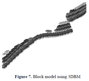
Upon finishing the creation of the solids for the seams, we switched from the GMS (Grid seam model) to the 3DBM (3D block model) and started generating economic envelopes using the EP (Economic planner) tool. It is here that the topographic coding took place (Figure 7).
4. MINE DESIGN
4.1. Economic Design and Sequencing for the Mining Process
The MSOPIT tool generated an economic design for the final pit and the various phases. To this end, geometric design parameters such as the pit's final angle were defined. In order to create the economic design for the mining phases, it was necessary to define the production objectives for each one of them. The production required for each mining phase is 600,000 tons of coal, and each phase will have an approximate size of 4,200,000 tons.
The MSOPIT application generated an economic envelope resembling the pit's final design (Figure 8), which can be used to start to create the pit's operational design. [8]
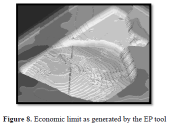
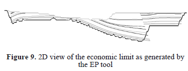
Figure 9 is an analysis which demonstrates that there is a portion of the seams in the project whose extraction would not be profitable, as they are located outside the economic limit. Thus, they will not be exploited because their net value is negative.
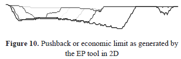
The MSOPIT program generated four mining phases represented by the colors appearing in figure 10. The production requirements for each period were taken into account during this process. The objective of executing the MSOPIT program Multiphases (MultiP) is to design the project's economic phases whilst searching for an optimal sequence for the exploitation of the site that maximizes benefits throughout the project.
The economic assessment was carried out using the MSVALP program, which is part of the EP (Economic planner) software package. MSVALP allowed us to assess the different mining phases generated by the MSOPIT program.
Before using the MSVALP, production objectives were defined in the same manner in which they were when using the MSOPIT tool to construct the four mining phases. [9]
Figure 11 shows the results of the assessment performed using MSVALP. The values throughout the entire project can also be observed. Additionally, the program uses production requirements to calculate the project's lifespan. In this project, the calculated lifespan was 10 years, assuming that each phase is extracted in one year.
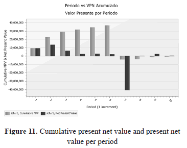
After analyzing figure 11, a financial deficit was found for period 7 due to the fact that there was an increase of approximately 600% in the stripping ratio. The reason behind this could be that only 4 phases were generated, and the program carried out the economic assessments for this period without any restrictions in the ore to be exploited.
4.2. Operational Design
Figures 12, 13 and 14 show the operational designs that were digitized for this project. These designs were created using the Pit Expansion tool for each of the phases in which ore extraction will take place throughout the project's lifecycle, whilst retaining the geotechnical parameters.
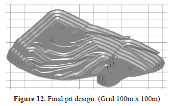
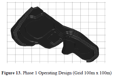
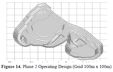
After obtaining the operational pits for each phase, the solids representing the material to be extracted for each phase were generated.
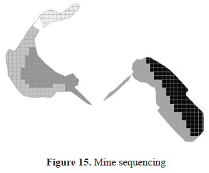
5. SHORT-TERM PLANNING
A mining sequencing was programmed for phase 1 using the MineSight® Interactive Planner (IP) tool. To program the sequencing, it is necessary to generate a polygon measuring half a bench for the long-term phases that represent the solid of each extraction phase exactly [10].
For the sequencing of phase 1, regular polygons measuring 20m by 20m were generated inside the representative polygons of the phase 1 solid. It was defined that the phase would span one year of mining. Therefore, smaller 1-month subperiods were generated and represented with colors in the sequencing (figure 15).
6. CONCLUSIONS
The following are some of the conclusions arising from this study.
- This sequence of processes can be applied to other mining projects and to other types of minerals which have the same formation conditions as this deposit. In such cases, parameters should be changed to reflect the conditions of the new site, as well as the conditions for exploitation, thus improving the mine's productivity and optimal life.
- In open pit mining involving sedimentary deposits of coal, several modeling and design methods can be implemented with easy-to-use tools. GSM (Grid seam model) is an extensive set of programs designed to address the problems encountered in the assessment of stratified sites and subsequent mine planning.
- One of the main advantages of using Minesight for digitizing stratified deposits semi-automatically is that it reduces the time required to model seams and interpret the data for design.
- Minesight can be a great help for the Colombian mining sector in terms of project development due to its highly accurate mining models and designs. It can also simulate several possible scenarios thanks to its integrated planning system that has experience in diverse sites throughout the world.
- The programs MSOPIT and MSVALP can generate designs and economic analyses quickly and show interesting information such as the net present value for each phase, the stripping ratio, costs per ton of sterile matter and the cost per ton of material of interest, etc. The MSVALP program generates sequencing which is effective and efficient in the long-term, and which calculates the project's lifespan.
ACKNOWLEDGEMENTS
The authors would like to thank Vale Coal Colombia, Colciencias and the National University of Colombia for their financial support for this research project, entitled Stochastic Optimization Model for Open Pit Mining, QUIPU code: 20201009482.
REFERENCES
[1] Hustrulid, W. and Kuchta, M., Open pit mine planning & design. Taylor & Francis plc., London, UK. 2006 [ Links ]
[2] Botín, J., Guzmán, R. and Smith, M., A methodological model to assist in the optimization and risk management of mining investment decisions. En: DYNA, year 78, Nro. 170, pp. 221-226. Medellín. 2011 [ Links ]
[3] Builes, A., Planeamiento de la producción mina El Hatillo, trabajo dirigido de grado presentado como requisito para optar al título de Ingeniera de Minas y Metalurgia, Universidad Nacional de Colombia, sede Medellín, Facultad Nacional de Minas, Medellín. 2011 [ Links ]
[4] Pendola, M. and Castañeda, C., Phases generation and optimization. Proceedings second international seminar on mine planning, 2011. [ Links ]
[5] Mintec. MS3D: true tickness tools, Minesight® monitor, Boletín informativo, Chile. 2010 [ Links ]
[6] ______________. Adding Roads and Benches to a Pit Design. The Name MineSight® and the Program described are property of Mintec Inc - Tucson, Arizona. 2007. [ Links ]
[7] Arteaga, R. y Zapatero, M., Planificación de la ejecución del proyecto. Manual de evaluación técnico-económica de proyectos mineros de inversión. pp. 50-54, ITGE. 1991 [ Links ]
[8] MINTEC. Economic Planner de MineSight® para usuarios ocasionales. 24th Seminario anual Mintec. 2007. [ Links ]
[9] MINTEC. MineSight Economic Planner para Usuarios Avanzados. 28th Seminario anual Mintec. 2011. [ Links ]
[10] MINTEC. Minesight® Interactive Planner (Planeador Interactivo): Una herramienta ideal para Planificación y Reportaje de Modelos de Bloque, Modelos de Mantos, y Archivos de Mallas de Superficie. 24th Seminario anual Mintec. 2007. [ Links ]
