


Serviços Personalizados
Journal
Artigo
 Inglês (pdf)
 Artigo em XML
 Referências do artigo
 Enviar este artigo por email
Indicadores
-
 Citado por SciELO
 -
 Acessos
Links relacionados
-
 Citado por Google
 -
 Similares em
SciELO
Similares em
SciELO -
 Similares em Google
Compartilhar

 Permalink
DYNA
versão impressa ISSN 0012-7353
Dyna rev.fac.nac.minas vol.81 no.185 Medellín maio/jun. 2014
https://doi.org/10.15446/dyna.v81n185.34841
http://dx.doi.org/10.15446/dyna.v81n185.34841
Potential for geologically active faults Department of Antioquia, Colombia
Potencial de fallas geológicas activas Departamento de Antioquia, Colombia
Luis Hernán Sánchez-Arredondo a & Orlando Giraldo-Bolivar b
a Departamento de Materiales y Minerales de la Facultad de Minas, Universidad Nacional de Colombia, Colombia. lhsanche@unal.edu.co
b Departamento de Ingeniería Civil de la Facultad de Minas, Universidad Nacional de Colombia, Colombia. ogiraldo@unal.edu.co
Received: November 7th, 2012. Received in revised form: March 13th, 2013. Accepted: April 11th, 2014.
Abstract
A geostatistics module (mg95) was determined based on geostatistical studies of global estimations of seismicity data reported by the National Seismological Network of Colombia [Red Sismológica Nacional de Colombia (RSNC)]. It enabled the level of activity of the cortical fault in the Department of Antioquia (DA), Colombia to be categorized. The mg95 relates the estimated values with polygonal kriging and the corresponding error for each one of the municipalities of Antioquia, with a Student parameter at 95% confidence, dependant on the number of microseisms registered locally. The following categorization scale is proposed to determine the levels of active faults in each municipality: proved active fault mg95∈[0-0.2], probable active fault mg95∈[0.2-0.3], and possible active fault mg95 > 0.3.
Keywords: seismology, geostatistics module, active faults, Colombia.
Resumen
Con base en estudios geoestadísticos de estimación global de los datos de sismicidad reportados por la Red Sismológica Nacional de Colombia (RSNC), se determinó un módulo geoestadístico (mg95) que permitió categorizar el nivel de actividad del fallamiento cortical en el Departamento de Antioquia (DA), Colombia. E lmg95 relaciona los valores de estimación con krigeage poligonal y su error correspondiente para cada uno de los municipios antioqueños con un parámetro de Student al 95% de confianza, que depende del número de microsismos registrados localmente. Para determinar los niveles de fallamiento activo en cada municipio, se propone la siguiente escala de categorización: fallamiento activo probadomg95∈[0-0.2], fallamiento activo probablemg95∈[0.2-0.3] y fallamiento activo posible mg95 > 0.3.
Palabras clave: sismología, módulo geoestadístico, fallas activas, Colombia.
1. Introduction
The first line of each paragraph is indented 0.5 cm. The Department of Antioquia is located in the north western corner of South America. It is one of the world's least understood regions because its geology is the result of the interaction of multiple geological processes and of tectonic plates and microplates that meet there. The seisms generated in this region show drastic changes in the focal mechanisms [1]. In the last 130 years, cortical active faults have generated earthquakes such as the one in Turbo 18822 and the one of in Murindo 1992[3].
2. Database
The seismicity analysis reported by the RSNC from June 1, 1993 to June 30, 2009, indicates that the Department of Antioquia has registered 2429 epicentres, of which 78% (1897) corresponds to superficial activity, (77% of the data is located at a depth of 3 Km.) with a local magnitude (ML) of 2.7, and 25% of the data in the interval 3 ≤ ML ≤ 5.3.
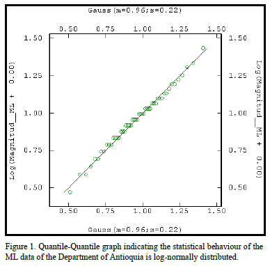
The quantile - quantile chart (Q-Q plot) of Fig. 1, indicates the strong tendency of superficial microseismic activity in the DA, to behave statistically as a log-normal distribution for the data of local magnitude.
3. Structural Geostatistics
A semivariogram whose graph assimilated an exponential type model (Fig. 2), with an influence range for seismic data of 5 kilometres and a real variance (plateau) of 0.31 developed as the main geostatistical tool to evaluate the spatial behaviour of the superficial seismic activity in the Department of Antioquia.
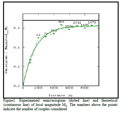
The semivariogram model for the ML variable was validated regionally with 1725 seisms, a standardized error
average of 0.005, and a standardized error variance of 0.88. The model rejected 0.4 % of the data inside a 100 Km radius. The equation representing the model is the following.

The global estimate was based on the geostatistical technique known as "polygonal kriging". This procedure was designed to provide an estimated value of seismicity, inside the areas delimiting the polygonal coverage of each one of the municipalities of the DA. Each municipality receives a unique global estimate value with its corresponding error. The number of seisms considered for the estimates inside each municipality, is equivalent to the local epicentres, plus those located outside the municipal polygon but inside a 5 km outline, which corresponds to the influence range deduced from the semivariogram (Fig. 2).
4. Geostatistics Module And Categorization Of Geologically Active Faults
The level of geological fault activity, or segments of geological faults belonging to a system, was defined with a confidence factor of 95% labelled "geostatistics module (mg95) to characterize the level of activity of geological faults".

t depends on the number of seisms considered.
The study case of the municipality of Murindo (Fig. 3) will be used as an example.
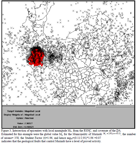
Global estimation error = 0.11
Global estimated seismicity (ML) =2.91
Number of seisms considered = 358
Student factor = 1.96, (see attachment)

If the number of epicentres increases, the estimation error and the Student factor decrease and, therefore, the level of threat by active faults increases.
Thus the mg95 is used to categorize the level of active faults of the DA, based on the fact that the presence of cortical seismic activity implies the presence of active geological faults.
Thus the mg95 is used to categorize the level of active faults of the DA, based on the fact that the presence of cortical seismic activity implies the presence of active geological faults.
The classification levels for geological fault activity are proposed considering the mg95 values obtained for each one of the municipalities of the DA, (Table 1).
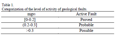
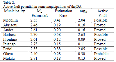
Table 2 summarizes the results obtained for some municipalities in the DA.
5. Discussion
Regionally the territory of the DA is affected by the triple union of the convergence of the Caribe, Nazca and Suramericana tectonic plates. This contact zone is represented by two microplates called bloque Andino and bloque de Panamá Baudó [4]. As a consequence of this geotectonic activity, three geological fault systems control the seismological activity in the DA: The Cauca Romeral System, cartographed since the start of the 20th century [5], the Palestina Fault System [6], and the Mutatá-Murindó Fault System (Suture of Dabeiba).
For some authors [7], seismicity in Colombia's Northwest is diffused and complex and caused by the fault generating compression east-west. This implies that these hypotheses suppose that seisms generated in the region are not caused by subduction, but the result of the convergence tectonic plates and microplates.
The geostatistical results obtained in this research indicate that 42% of the municipalities of Antioquia are controlled by geological faults with a proved level of activity. 24% of the municipalities determined in this level are related geotectonically to the Mutatá-Murindó Fault
The highest potential for active faults in the DA is registered in the municipalities of Ituango (Cauca Romeral Fault System, Suture of Dabeiba), Dabeiba, Urrao, Uramita, (Palestina Fault System).
Cañas Gordas, Murindó (Suture of Dabeiba) and Remedios
The cortical fault presenting the largest threat for the DA is related to the Mutatá-Murindó Fault System (Suture of Dabeiba). Considering the external seismic threat presented by this suture for the Valle de Aburra (3,317,166 inhabitants) [8], home of the city of Medellín, the segments that pass through Urrao are the neotectonic features presenting the highest danger. They present potential for generating superficial seisms with a PGA (Peak Ground Acceleration) of 0.96g (units of gravity), which may arrive at Medellín, with a acceleration of 0.25g. Historically, one of the most representative seisms in the zone, related to the Suture of Dabeiba, is the one that occurred on September 7, 1882, with an intensity of X in the Mercalli Scale and an Ms magnitude estimated between 6.5 and 7.2. Likewise, this seism was felt intensely in the Isthmus of Panama and in a large part of the Departments of Antioquia and Choco1. Similar to the seism of 1982, most of the Uraba Region was affected by the seisms of October 17 and 18 of 1992, which brought about countless damage to the environment and the urban centres of Colombia's Northwest3. The event of October 18 registered, in an accelerograph located in ISA in the city of Medellín, a maximum horizontal acceleration of 0.03g. This is a pretty low value considering the damage registered [3].
The faults related to the Suture of Dabeiba, as well as the faults related to the Cauca Romeral system, affect the territory of the Municipality of Ituango. The seismic activity registered there is moderate with 110 superficial seisms, housing high geostatistical potential for the generation of microseismic activity, with a high potential danger for the Valle de Aburra (PGA of 0.18), which is to say 0.176g of horizontal acceleration. Additionally, the close relationship shown by the results obtained in this research with the neotectonic studies made so far about the faults systems of the Cauca Romeral System in the northwest of the DA [9-11] is remarkable.
In conclusion geostatistics can be used as a valuable tool for supporting seismology. It complements neotectonics and geochronology (carbon-14) studies and can be used to take decisions when instrumenting and monitoring the places with the greatest seismic threats.
Acknowledgements
This article is a contribution to project 9536 "Seismic Threat of the Department of Antioquia Based on Microseismic Activity of the RSNC" Phase I, financed by the Office of Research of Universidad Nacional de Colombia, Sede Medellín (DIME).
References
[1] Cardona, C., Salcedo, E. Y Mora, H. Caracterización Sismotectónica y Geodinámica de la Fuente Sismogénica de Murindó – Colombia.(www.geoslac.org/memorias2/memorias/.../sismot_geodinamic a_col.pdf, mayo 27/2010). [ Links ]
[2] París, G., Machette, M., Darat, R. and Haller, K., 2000. Map and Database of Quaternary Faults and Folds in Colombia and its Offshore Regions: USGS (International Lithosphere Program), 61 P. [ Links ]
[3] Martinez, J., Parra, E., París, G., Forero, C., Bustamante, M., Cardona O. Y Jaramillo, J., 1994. Los Sismos del Atrato Medio 17 y 18 de Octubre de 1992: Revista Ingeominas (no. 2), Bogotá, pp 35-76. [ Links ]
[4] Toussaint, J.F. Y Restrepo J.J., 1987. Límites de Placas y Acortamientos Recientes entre los Paralelos 5°N y 8°N, Andes Colombianos: Revista Geológica de Chile (no 31), Santiago de Chile, pp. 95-100. [ Links ]
[5] GROSSE, E., 1926. El Terciario Carbonífero de Antioquia : Dietrich Reimer, Berlín, 361 P. [ Links ]
[6] Feininger, T., Barrero, D. and Castro, N., 1972. Geología de la parte de los departamentos de Antioquia y Caldas (Sub-zona IIA, oriente de Antioquia): Boletín Geológico Ingeominas V.20 (2), Bogotá, 173 P. [ Links ]
[7] Pennington. W. ET AL., (1988). Seismicity of the Caribbean - Nazca Boundary: Contrains on Microplates Tectonics of the Panamá Región. Journal of Geophysical Research. Vol. 93. no. B3, pp 2053 - 2075. [ Links ]
[8] DEPARTAMENTO ADMINISTRATIVO NACIONAL DE ESTADÍSTICA: Censo 2005. (Http: //es.wikipedia.org/wiki/DANE, junio 17 de 2010). [ Links ]
[9] Arias, L.A., 1981. Actividad Cuaternaria de la Falla Espíritu Santo: Revista CIAF, Vol. 6, pp. 1-16. [ Links ]
[10] WOOWARD & CLYDE CONSULTANTS, 1980. Phase I, Preliminary Seismic Hazard Study Ituango Proyect, Colombia: Unpublished report for Integral, Ltda and ISA, Medellín, 152 P. [ Links ]
[11] Cline, K., Page, E. Gillan, M., Cluff, L., Arias, L., Belarcazar, L. Y and López J., 1980. Quaternary activity of the Romeral and cauca Faults, Northwest Colombia: In Seminario sobre el Cuaternario de Colombia, no. 1, Resumenes, -vol. 1, Bogotá, pp. 37-38. [ Links ]
L H. Sánchez-Arredondo, received the Bs. Eng in Geological Engineering in 1984 (Universidad Nacional de Colombia. Medellin, Colombia.), the Sp degree in Analysis and Management of Geological Risk in 2001 (University of Geneva. Geneva, Switzerland), and the MS degree in Master Coal Science and Technology in1991 (Universidad Nacional de Colombia. Medellin, Colombia.), He is a Full Professor in the area of mining geology and geostatistics in the department of materials and minerals, Facultad de Minas, Universidad Nacional de Colombia. His research interests include: Exploration Geochemistry, Geostatistical Modeling and Simulation, Risk in Geology and Mining.
O. Giraldo-Bolivar, received the Bs. Eng in Civil Engineering in 1981, the Sp degree in structures in 2000, all of them from the Universidad Nacional de Colombia. Medellin, Colombia. He is a Full Professor in the area of Materials and Structures in the department of civil engineering at the National University of Colombia, Medellín. His research interests include: Architectural precast concrete panels, Evaluation of chemical additives for concrete, concrete quality control of civil works.
