


 Inglês (pdf)
 Artigo em XML
 Referências do artigo
 Enviar este artigo por email
 Citado por SciELO
  Citado por Google
  Similares em
SciELO
Similares em
SciELO  Similares em Google
 Permalink
1. Introduction
Colombia has complex geomorphological and topographical conditions which create difficulties when constructing and maintaining the road network. The range of altitudes also generates inconveniences when extending or modifying the network. Since the second decade of the 20th century, the construction of road tunnels has become an opportunity for innovation and improvement of the national road infrastructure, representing an important element for boosting the country’s growth [1].
Thus, by 2002, Colombia had 33 completed and in operation vehicle tunnels, equivalent to 18,540 linear meters; by 2010, the figure had increased to 90 tunnels, equivalent to 77,929 linear meters. These projects do not take into account the second wave of Fourth Generation Concessions recently awarded, in which the estimated number of tunnels is 110, and which is expected to make Antioquia the region with the largest number of kilometers of tunnels in Colombia over the coming years [2]. Among these projects, the Fernando Gómez Martínez Tunnel (Conexión Vial Aburrá - Río Cauca) stands out, which is 4.6 km long and located on the Medellín - Turbo Road. However, an initial review of the country’s main road tunnel projects may lead to the preliminary conclusion that there are socioenvironmental conflicts1 associated with them due to complaints of alleged environmental impacts.
In light of these circumstances, the importance of investigating the causes of the environmental impacts caused by the construction of tunnels in Colombia was demonstrated using the proposed ex-post evaluation methodology2 for this case study. Using this method allowed us to analyze whether the environmental studies carried out considered possible impacts on the environment generated by the construction of these works with due depth and importance, revealing in this case a lack of environmental planning; or if, on the contrary, the reality faced is mainly due to the existence of gaps in the applicable environmental regulations, and if this is related to the absence of an adequate monitoring and control process by the environmental authorities.
The Conexión Vial Aburrá - Río Cauca project was chosen, which began construction in 1997 and was operating by 2006. This project represented a special interest due to the fact that the construction of a second pipeline is being planned - currently in the study and design stage by the Agencia Nacional de Infraestructura3 (ANI, National Infrastructure Agency). An analysis of environmental management in the pre-construction, construction and operation phases of the first stage of the project was then carried out through the design and application of a model based on the ex-post evaluation methodology [3]. This made it possible to identify relevant aspects in the execution of the project by the different actors involved in its environmental management, as well as to establish conclusions and recommendations that can be considered in road tunnel construction projects in general.
2. Background information
2.1. Importance of ex-post evaluation as a tool for environmental management
A review of existing research on the subject found that Colombia has historically lacked a culture of implementing ex-post evaluations, a situation that is also a problem in several countries around the world. The only evidence found of having developed an ex-post evaluation was for the pilot tunnel ‘La Línea’. In this evaluation, the impacts caused by the project and the fulfillment of the objectives and goals were presented, with negative results due to the apparent irreversible nature of the impacts caused.
In 2007, the Institute of Regional Studies of the University of Antioquia (INER) prepared the “Study of the Social, Economic, Political and Cultural Impacts of the Aburrá - Río Cauca Road Connection” for the Fernando Gómez Martínez Tunnel [4], in which the positive and negative impacts caused on the territorial development in western Antioquia were identified, and strategic guidelines were formulated for their management by the different municipalities. There is also the “Master Plan for the Territorial Planning of the Scope of the Project for the Valle de Aburrá - Río Cauca Road Connection in the Western Antioquia Region” [5], in which basic concepts, principles and prospects were defined, as well as a methodological synthesis, strategic lines, diagnosis and description of the scenarios and contingency actions that, in the opinion of the School of Urban & Regional Planning, should be executed immediately and within a maximum period of one year.
As for other road tunnel projects developed in Colombia, such as the Sumapaz Tunnel and the pilot tunnel ‘La Línea’, the Ministry of the Environment, Housing and Territorial Development contracted Colombia’s National University, Water Resources Engineering Research Group, to prepare the “Evaluation of the Impact of Construction on the Neighboring Ecosystems.” This study evaluated the impact of the construction of tunnels on the surface and underground water resources of the surrounding areas, determining that the tunnel effectively depressurized the system, causing the drainage of water bodies such as La Gata Creek and the reduction of others such as La Cristalina Creek [6].
In 2010, the Inter-American Development Bank prepared the “Ex-post Impact Evaluation of Environmental Mitigation Measures for the Porce II Hydroelectric Project” [7], and in 2008 it prepared the ex-post evaluation of mitigation measures in the Samalayuca II and Monterrey III thermal generation projects [8].
Upon doing a background review for projects involving the construction of tunnels in different parts of the world, it was found that for Asia, within the studies carried out to assess the environmental impact for the “Tseng Wen Reservoir Diversion Project” in Taiwan [9], timely identification of environmental impacts on water resources was of great importance for the planning, design and construction of tunnel projects, as accidents and delays in the project during construction could be minimized. In this research, software was used to determine the impact of tunnel excavation on the hydrogeological environment in a regional area around the tunnel and in a hot spring area.
With regard to ex-post evaluations implemented in large projects in Europe and which could serve as a guide for the present investigation, we found one carried out on the Øresund Bridge in Copenhagen [10], which provides a socioeconomic analysis and compares it with the evaluation for the Eurotunnel project or the Channel Tunnel [11], in which the errors committed during the planning and construction of the aforementioned are analyzed, but mainly in terms of methodological, social and political aspects.
For its part, it is important to take into account the article “Influence of Reference Points in Ex-post Evaluations of Rail Infrastructure Projects” [12], in which the author analyzes the ex-post evaluation of four railway projects in Norway, finding that the choice of study parameters usually influences the results of the evaluation by presenting them as failed or successful projects, depending on the year chosen to carry out the study and the indicators to be evaluated, and therefore recommending that more than one ex-post evaluation method be applied for more reliable results.
Another alternative is to apply the proposed methodology to similar projects, with the possibility of comparing the results and identifying similarities in the execution, operation and settlement stages of projects. This allows us to define how many of the a project’s objectives have been achieved or how much capacity a similar project has in order to attain them, for which Zapata Puerta and Tovar Olano, Colombian authors, in their master’s thesis [13], present their methodological considerations applied to projects at an international level.
With regard to ex-post Environmental Impact Assessments, the Chinese author, QG Wang [14], states that “Once the projects are completed, the actual environmental impact caused can be determined by implementing an Environmental Impact Post-Assessment (EIPA), and can be compared with the impacts predicted in the Environmental Impact Assessment (EIA)4, the differences found can be used to predict the effectiveness of the EIA in protecting the environment, replicating the results to similar projects to maximize the positive impacts”.
It can be concluded then, that the implementation of ex-post evaluation is clearly important in the monitoring and control of projects, given the advantages it represents in terms of identifying the effectiveness, efficiency and compliance of the proposed measures from the pre-feasibility stage of the projects, in order to design strategies that are considered useful not only for project executors, but also for state entities and environmental authorities in establishing improvement measures.
In general, for large projects, it was found that although the different entities have carried out studies to provide solutions to problems subsequent to the construction of the project, an ex-post evaluation methodology has not been implemented which transcends the reality that the territory has to contend with during the operational stage of the project and which is aimed at determining the effectiveness of the Environmental Impact Assessment (EIA) and Environmental Management Plan (EMP), facilitating its environmental closure and generating management recommendations for future projects.
3. Methodology
The Aburrá - Río Cauca Road Connection project was chosen, which includes the construction of a 4.6 kilometer tunnel, beginning construction in 1997 and operation in 2006. This project represented a special interest due to the fact that the construction of a second pipeline is currently planned - a stage that is currently being studied and designed by the ANI - but which has already generated some opposition in the neighboring community, who report having suffered the environmental impacts of the first stage of the project, which according to the community have not been fully compensated.
In order to establish the methodology to be followed for the application of the proposed evaluation, a review of the existing bibliography related to the ex-post evaluation was carried out. We found that there is no defined procedure for standard projects, nor is there any norm in this regard, so proceeded to design a model, based on the ex-post evaluation methodology, which was applied to the project in its different phases, studies, designs and construction. Fig. 1 shows the description of the methodology.
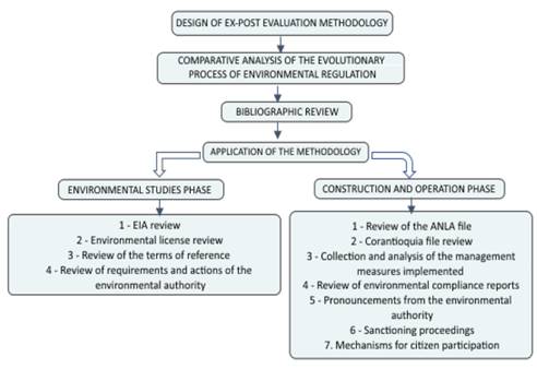
In order to evaluate the road project during the environmental studies stage, a model was designed containing the main requirements and obligations included in the terms of reference issued by the environmental authority for the preparation of the EIA for road infrastructure projects contained in Auto 234 of 1996. We applied the evaluation model to the study carried out in 1996 and obtained as a result a comparative analysis of the information supplied to the environmental authority and the possible gaps in it.
For the construction stage, file number 0678 was reviewed (which was consulted directly in the National Environmental Licensing Authority’s file). The compilation and analysis of the environmental management measures implemented in the construction and operation stages, reported in the Environmental Compliance Reports submitted to the authority, and the main actions of the national and regional environmental authority were carried out. During the review, the sanctioning measures imposed on the road project and the interventions of the different actors, mechanisms for citizen participation and the main judicial processes involved, degree of satisfaction of the benefited community, results, effects and residual impacts were identified.
Table 1 Technical Datasheet of the Aburrá - Río Cauca Road Connection Project
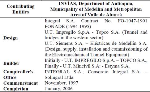
Source: Final audit report of the project. Integral, 2007.
Likewise, the models broken down by component of the subsequent standards related to the licensing of tunnel construction works were also presented. These models served as input for the analysis of the expected impacts with the construction of phase 2 of the project and guided the conclusions and recommendations of the research.
We focused on identifying the impacts generated by the construction of the Fernando Gómez Martínez Tunnel project based on the existing information in the different files of the project from the environmental authority, evaluating their relationship with possible causes of the socioenvironmental conflicts that arose, so that, based on the results of the application of the designed ex-post evaluation model, environmental management recommendations applicable to the second stage of the project can be identified and, in general, can be fed back as lessons learned in other similar projects.
4. Project description. Case study
4.1. General characteristics
The construction of the Aburrá - Río Cauca Road Connection project was carried out under an inter-administrative agreement signed by the National Roads Institute, the Department of Antioquia, the Municipality of Medellín and the Metropolitan Area of the Valle de Aburrá. ¡Error! No se encuentra el origen de la referencia.1 below presents the technical specifications of the project [15]:
4.2. Project location
The project is located in the Department of Antioquia, specifically in the municipalities of Medellín, (districts of San Cristóbal and San Sebastián de Palmitas), Ebéjico and San Jerónimo. Within the direct scope of the project, which includes the 4.6 kilometers of construction of the western tunnel, the following municipal districts were identified in the field verification trips: Naranjal, La Cuchilla, La Frisola and La Volcana. This section divides the road corridor into three sectors that are described below:
Eastern sector - Between Road 80 and the eastern entrance of the tunnel in the district of San Cristóbal. The road in this sector is designed with a double roadway and central separator, and its layout runs parallel to La Iguaná Creek.
Tunnel - With a length of 4.6 kilometers, 76 m2 of cross section and a slope of 2.25%, it crosses the water divide between La Iguaná Creek, a tributary of the Medellín River, and the La Frisola Creek, a tributary of the Cauca River basin.
Western sector - With a length of 24 kilometers, between the western entrance of the tunnel and the final junction of the project with the current road to the sea at its intersection with the Aurrá River, in the municipality of San Jerónimo.
For the purposes of this investigation, the tunnel section is of particular interest.
4.3. Description of the scope of the project
The section corresponding to the tunnel is located in the district of San Cristóbal, which borders on the north with the municipality of Bello, on the east with the urban perimeter of Medellín, on the south with the districts of Altavista and San Antonio de Prado and on the west with the district of Palmitas. The center of the district is located 11 kilometers from downtown Medellín and has a total area of 49.54 km2 and a population of 34,877 inhabitants, according to the 2005 Statistical Annual of Medellín.
This area has a rugged terrain of mountainous canyons that form a system of small longitudinal valleys, with heights between 1800 and 3000 meters above sea level. The main hydrographic basin of the district is the La Iguaná Creek that crosses the entire territory in a west-east direction and has numerous tributaries that reach the mountains.
The main economic activity is agricultural production; a variety of products are created via intensive use and rotation of the land. Small crops are divided into areas that, according to a report from the Secretary of Community Development, mainly oscillate between 1.5 by 15.5 meters. The principle products grown in the region are vegetables, flowers and, to a lesser extent, fruits and herbs.
The San Cristóbal District is located within the category of suburban land, subcategory of rural population centers, made up of the areas that have the adoption of the necessary provisions to regulate the occupation of their land and the adequate provision of basic public services infrastructure and equipment.
One of the modifications brought about by the construction of the road project is that both districts adopt the category of suburban land, according to which certain areas are constituted into areas or polygons in which rural land uses and rural and urban lifestyles coexist, with housing densities lower than those permitted in rural population centers.
As a result, for the San Cristóbal District, there is a 5.8 hectare polygon defined as a conservation zone. In general, in accordance with the 33/5000 Plan of Territorial Ordinance [16], these areas are part of the protected zones defined for the territory - included in the main ecological structure - and are areas of high threat and non-mitigable risk, which are considered as soils in need of environmental protection in the light of the present regulations.
This approach aims to ensure ecological connectivity, soil stability and regulation of the hydrological system. In general, these polygons are part of the sustainable production areas of the Valle de Aburrá - Río Cauca Integrated Management District and the Nare River Protected Forest Reserve and include part of the ecological connectivity network of the main and complementary ecological structure.
5. Environmental planning of the project
The company Integral was contracted to carry out the Environmental Impact Assessment in 1996. This study identified the impacts caused by the construction and execution activities of the project on the different environmental elements. The impacts were graded and prioritized in order to establish the elements, components and systems that would be most affected by the construction of the project. Finally, for each of the environmental systems - abiotic, biotic and anthropogenic - the document describes the effects generated by the project, the mitigation, prevention and control measures, and some recommendations.
For the preparation of the EIA, the multifactorial evaluation methodology was used, for which an analysis was conducted of the environmental supply with the characteristics of the area at the time of the study, and of the environmental demand defined by the characteristics and processes for the execution and operation of the project. Subsequently, the project was broken down into activities and the environment into systems, components and elements. With this information the identification model was constructed which established which project activities/processes are more likely to generate a greater number of impacts on the environmental elements and which of these are more sensitive to said activities.
The study describes parameters measured by water quality, air quality, analysis of land use, land use conflicts, biotic aspects, urban aspects, landscape, social infrastructure, and socioeconomic, sociocultural and archaeological aspects. As a result of the identification model, the environmental effects data sheets corresponding to each stage of the project and the impact rating table for each of the interactions described in the effects data sheets are presented.
Along with the main conclusions resulting from the review of the environmental planning phase of the project, it should be noted that although the methodology applied constitutes a procedure that allows the identification of the cause and effect of the different activities to be carried out in the different stages of the project and the possible impacts to be generated, it can be said that the impact identification model completed for the project does not consider in depth all the interactions between the activities to be developed and the elements and components proposed, leaving aside the possible important impacts associated with the construction of road tunnels. This consideration is justified throughout this document as a conclusion of the analysis of the different impacts identified in the study.
Specifically for the case study, the Environmental Management Plan5 includes plans for operational, physical and social management, in which the measures to be implemented to prevent, control, mitigate or compensate for the impacts identified as relevant within the impact assessment model were established.
Among the main results obtained for the environmental planning stage of the project, the impacts mentioned in the EIA, section 5.3.1.2, Water Component, presents the possible affectation to fluvial dynamics: alteration of the state of geomorphological equilibrium of the currents due to flow deviations, changes in the slope of the riverbed, cuts, construction of sewers, bridges, etc., modifications in the flow regime, in the water table and in the capacity of sediment transport. Table 5.1 shows the relationship between surface and underground excavations and the effect on river dynamics, referred to as a noticeable effect on the entire corridor to be built.
However, when analyzing the impact ratings presented in Table 5.2., Environmental Qualifications Construction Stage, we can see that the value for the implications of the underground excavation activity on the river dynamics is 0.03 and for surface excavations, 0.07. In addition, the weight assigned to both activities is 0.25, which leads to a score of ‘mild’ as stated in chapter 5.6, Analysis of Results. The vast majority of interactions in the construction phase are in the ‘very mild’ category: 41 in total, equivalent to 60%. Of these, 46% can be considered negligible as they have a rating of less than 0.05.
This is without including in the study the description and supporting documentation of complementary studies that allow the reasons for the assigned values to be determined.
The environmental license6 for the project was granted by the then Ministry of the Environment through Resolution No. 0762 of August 15, 1995 and corresponds to a Standard Environmental License. It establishes the requirements, conditions and obligations that the beneficiary must comply with to prevent, mitigate, correct, compensate and manage the environmental impacts of the project, work or activity authorized, without providing for the granting of permits, authorizations or concessions for the use, exploitation or mobilization of renewable natural resources.
6. Description of the socioenvironmental problem associated with the case study
When reviewing the information contained in the Autoridad Nacional de Licencias Ambientales’s (National Authority of Environmental Licences, ANLA) file 0678, it was found that, during the month of December 1999, residents of the municipal district of Naranjal in the district of San Cristóbal denounced the depletion of water sources that were used for irrigation of crops. According to the internal communication of the Government of Antioquia, number 168, April 13, 2000, corresponding to the report of the municipal district Naranjal, several visits were made to 11 reported points, revealing the collapse of 3 water sources located in the area of the eastern entrance of the tunnel.
Subsequently, the aforementioned report describes: “The municipal district of Naranjal corresponds to a sector of rural characteristics and dispersed rural dwellings with a predominance of vegetable and flower crops. Particularly in the affected area there are a total of 42 dwellings and approximately 208,000 m2 of cultivated land, as described in the report, with changes in the hydrological regime being evident. Specifically, at the time, 17 families relied on the 3 springs reported as deteriorated”.
According to Comptroller’s Memorandum 1324-E-1147, of the 3 water sources reported as disappeared, only water source number 1 was gauged, since the others were not known to exist when the census was conducted with the local inhabitants.
Reviewing the file of the Corantioquia project, the Technical Report AB 00 00216 of February 23, 2000 was found, which corresponds to the visit carried out to address the complaint about the alleged effects that the construction of the tunnel brought to the municipal district of Naranjal. The objective of the visit was to evaluate the situation, make a diagnosis, identify the factors that caused the situation, determine whether or not the road project is responsible and propose technical alternatives for solutions.
One of the main conclusions of the Corantioquia report is: “According to field observations, there is only one factor that can cause the infiltration of the waters of these springs: the presence of the tunnel under construction for the Valle de Aburrá-Rio Cauca road interconnection. With the presence of the tunnel work, an empty space has been created inside the earth that generates the infiltration of surface water by gravity and the lowering of the water table”. A conclusion based on field observations and not on verification studies.
Corantioquia makes the following recommendation: “Due to the importance of water for the inhabitants of the municipal districts adjacent to the western tunnel projection line, it is necessary to propose a measure to guarantee water supply to the inhabitants of the area. According to the high population, the agricultural tradition (vegetable crops) and livestock sector, it is essential to have a supply of water, both for domestic and agricultural use”.
The file contains “Design of the System for Water Collection for Irrigation in the Municipal District Naranjal”, prepared by the company Integral in 2003. However, during the investigation for the damage, it was found in file number 0678 of 1997, that the Ministry of Environment, Housing and Territorial Development, through Resolution 0358 of 2006, opened an investigation and issued a statement of objections to the National Roads Institute as the holder of the environmental license, among other reasons, requiring the presentation of the schedule of water supply works for the houses in the Naranjal municipal district, and for not having initiated works [17].
The Governor’s Office of Antioquia presented its Technical Report on Waivers on April 21, 2006, according to which it stated that: “The compensation had not been executed to date due to the refusal of the owners to allow the transfer of the piping and the non-acceptance of the appraisals presented.....The community was willing to have the restitution of the water changed, compensating them with the improvement of the road that leads to the municipal district of Naranjal or the construction of a football field. One can see that the community has the precious liquid and can cultivate and exploit their lands agriculturally, without losing the vocation they had” [18].
It can be observed that, although a consensus was reached between the project and the community, as a result of a working group set up by the Agrarian and Environmental Attorney General’s Office, compliance with the commitments to restore the irrigation system did not materialize. The community’s comments do not compensate for the fact that the water availability was changed by the paving of a local road, despite the fact that this activity is the result of an agreement between the parties.
7. Results
As the main results of the implementation of the ex-post evaluation model for the environmental studies stage, when reviewing the content of the project’s EIA and comparing it with the terms of reference contained in Auto 234 of 1996, it can be concluded that there is a lack of depth and detail in the following areas: blasting, description of necessary materials, requirements for channel occupations, transfer of electrical networks, maintenance program, scope of the project, and analysis units.
In addition, it presents little depth and analysis in relation to the identification of the possible impacts that the excavation of the tunnel could generate on the surface and/or underground springs. Furthermore, taking into account that no information was found that was requested in the terms of reference contained in Auto 234 of 1996, applicable at the time, specifically with respect to groundwater hydrology, analysis of land vulnerability as a function of the permeability of materials and their relationship with aquifers, inventory of water points, sources, springs and outcrops, and information on risks of contamination and recharge of aquifers, the temporal evolution of groundwater levels or information on the direction of underground flow lines. Similarly, no evidence was found that the environmental authority had requested information on the matter.
For its part, the Evaluation Model for the Construction and Operation Stage made it possible to identify that for section 6.2, Physical Management Plans, in relation to the activities proposed in 6.2.1 Material Management, the status of the main sites authorized by the environmental license and its modifications for excavation material deposit zones is analyzed, based on Auto 4204 of 2015 [19], through which the environmental authority presents an updated consolidated report for these sites. As the main result of the analysis, the file does not include the closure of the obligation for any of the authorized sites, despite the fact that the project has been in operation since 2006.
According to Auto 4204 of 2015, ANLA reiterates the request to present a concept issued by Corantioquia on the non-existence of environmental impacts in the different Debris Management and Excavation Material Area used for the construction of the road project, which was initially requested by Auto 2937 of 2013. In this regard, it is found that the material management areas located in the jurisdiction of the Territorial Hevéxicos of Corantioquia, have the concept issued by the regional level environmental authority through Technical Report 130HX-1407-122669 of July 16, 2014. However, as of the closing date of this investigation, there is no evidence of the closure of these obligations by ANLA, despite repeated requests.
In the respective Environmental Compliance Reports, the progress of the reforestation activities has been included, which were carried out to partially comply with the EMP. As was the case for the document requesting the closure of commitments sent to ANLA in 2013. However, there are no ANLA pronouncements regarding the closure of this obligation, although follow-up visits are reported.
In general, within the monitoring and control process, the different actions of the environmental authority concentrate on repeatedly requiring, year after year, the same information related to activities such as slope treatment schedules, plans and receipt certificates from the owners of the deposit sites, signage for environmental awareness (installed since 2010), public lighting (which can be seen with the naked eye), reforestation measures, among others, ignoring the evidence of compliance provided in the different Environmental Compliance Reports, and without making a substantive statement on aspects of greater importance that are pending environmental closure, such as the complaint of alleged damages caused by the construction of the tunnel to the water sources in the Naranjal area, the closure of Debris Management and Excavation Material Area and the presentation and execution of the 1% Investment Plan7.
Additionally, it is found that the visits by the environmental authority are carried out approximately every year and producing the corresponding technical report can even reach a similar time period. This lack of agility makes it difficult to request and implement timely corrective actions, and turns the control process into an endless process, instead of achieving its monitoring function with the expected results.
As for the capacity of the environmental authority, Correal8, considers that it does not have sufficient personnel available to meet current licensing and project monitoring needs. However, he believes that recently, efforts have been made to incorporate specialists in the hydrogeological field, taking into account the conflicts that have arisen over the construction of tunnels in Colombia. Nonetheless, the general scheme of monitoring and evaluation that the environmental authority has is not very adequate for the country’s development projects, through which temporary associations9 of a team of professionals from the social, biotic and abiotic areas are formed, creating a high variability in the personnel assigned to the projects, making the monitoring and control process difficult.
The above results are validated with the considerations issued by the Office of the Comptroller General of the Republic for the year 1998, indicating that the main shortcomings in the environmental licensing process are mainly due to the lack of technical capacity to evaluate EIAs, the difficulty of objectively defining the cases in which an environmental license is required, and finally, mention is made of deficient monitoring and control [20].
8. Conclusions and recommendations
The environmental license is conceived as a tool for formulating impact management strategies aimed at preventing, controlling, mitigating or compensating impacts; hence the rigor required for its development and implementation from the Colombian regulations that allow the creation of such projects under the principle of sustainability set forth in Article 3 of Law 99 of 1993. In order for environmental licensing to achieve this objective, there must be a comprehensive environmental assessment covering all dimensions so that the project is compatible with the concept of sustainable development and not just focused on economic development.
For its part, environmental impact analysis requires an interdisciplinary perspective, for which it is necessary to create a reference of the context that provides an integrated environmental understanding with the methodological analysis of the stages of execution and operation of the development project, including not only the identification of the impacts that can be attributed to the project, but also those caused by the dynamics of development of the region in which it is located [21].
In the particular case of road tunnel construction projects, the possible impacts of tunnel excavation on the hydrogeological system and on the environment should be taken into account, identifying in advance the impacts that their construction may have on groundwater and surface water in the scope of the project, the alteration of the initial local or regional groundwater flow, reduction of the flow and the impact on existing sources or accumulations of water.
In this sense, identification of the hydrogeological characteristics of the area of intervention, the estimation of the infiltration flows, the location of said filtrations and water pressures, need to be a priority within the environmental studies so they can be considered in the design and construction of the project [22].
In relation to the construction stage, it is important to monitor surface water and ground effects related to groundwater depletion. Instrumentation should be installed to monitor the variation of the water table on a regular basis and the infiltration flows, which will make it possible to verify the relevance of the estimates contemplated in the studies and the need for them to be re-evaluated.
Finally, as recommendations for the operation stage, control over the inventory of water points prepared as input for the baseline of the pre-construction stage must be maintained and instrumentation of the area for monitoring the variation in the piezometric levels must continue, as well as periodic monitoring of the infiltration flows of the tunnel and the composition of the water.
In order to improve environmental management in our country and guarantee the environmental planning of sustainable projects, it is necessary to improve the procedure in relation to the terms of the licenses, the thoroughness of the study of the documentation associated with the licensing process, the control and monitoring of the projects, institutional capacity, improve communication with the environmental authorities and response times, as well as the issuance of monitoring and control reports and access to information, so that they can respond to the challenges that environmental issues demand from them.
Furthermore, it is important to prioritize and emphasize the importance of the implementation of citizen participation mechanisms that enrich the planning process of a development project, and which make it possible to achieve social viability through information, consultation and agreement, through the generation of knowledge that involves communities in the identification and evaluation of environmental impacts and in the design of the respective Environmental Management Plan.
It is necessary to work on the coordination of the entities and institutions related to the development project, including environmental entities, so that joint efforts can be made in favor of the environment. Public or private actors must also work on the optimal organizational design adjusted to the environmental problems associated with their economic activity. Consulting companies need to focus on environmental issues, developing work models applied to the project for which they are hired instead of using generic formats that do not reflect the real situation of the site. And environmental authorities, for their part, must fully execute their roles of authorization, monitoring and control, systematization of existing information and generation of new useful information.
Finally, and perhaps the most important recommendation made throughout the research, is the mandatory implementation of ex-post evaluation methodologies for projects, with the advantages that this practice entails not only in the identification of the level of compliance with the obligations arising from environmental licensing, applicable regulations and various unforeseen events that arise during the different stages of the project, but also in the environmental closure, providing a general overview of management and lessons learned to implement in future operations subject to the much sought-after economic development of the territory.

