


 English (pdf)
 Article in xml format
 Article references
 Send this article by e-mail
 Cited by SciELO
  Cited by Google
  Similars in
SciELO
Similars in
SciELO  Similars in Google
 Permalink
1. Introduction
Terrain instability in slope and hillside, results each year in soil and rock mass wasting that, in turn, produces great material losses and considerable infrastructural and environmental damage, creating complex emergency situations that are not only difficult to manage but difficult to prevent. The most frequent manifestations of instability are the landslides.
Landslides in slopes and hillsides result not only from a combination of geological, hydrological and geomorphological conditions, but also from their modification because of geodynamic processes, vegetation, land use, human activity, as well as precipitation and seismicity frequency and intensity [1]. Beyond that, landslides are phenomena governed by uncertainty, due to the distinct types of movements, velocities, and failure modes that can occur, and diverse materials and geological conditions. Added to this, data reliability for analysis, human uncertainty and uncertainty of the mathematical models used for stability analysis are considered [2].
The above makes safety factor, as well as some other parameters obtained as a way of assessing stability, may be more or less reliable depending on whether or not the aforementioned degrees of uncertainty are considered.
2. Landslide risk
Landslide risk in slope and hillside can be defined as the probability that elements into jeopardy loss ensues, providing that landslides take place with a certain intensity during a specific risk exposure period. This is expressed as a mathematical function according to hazard and vulnerability levels, as it follows:
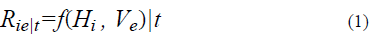
Where:
R ie│ t: Risk in the exposure period
H i : Hazard of intensity i,
V e : Vulnerability of exposed elements
The equation denotes that once the hazard is known, understood as the likelihood that a landslide with a certain intensity occurs during a specific exposure period; and once vulnerability is also known, understood as the predisposition of all the elements exposed or into jeopardy likely to be harmed; risk can be calculated. This risk calculation is understood as the probability of losses occurring on the exposed elements. Fig. 1 shows the factors involved in the risk expression, that takes into account the danger, the exposed elements and their vulnerability [3].
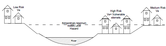
According to [4], landslide risk can be defined as the potential for adverse consequences or loss for the population and human property due to the occurrence of a landslide. While in [5], it is established that the risk assessment (R) involves the notion of hazard, vulnerability and cost, and it is mathematically defined as:
Where:
Hi = Hazard of intensity i,
Vji = Vulnerability for Hazard of the j elements,
Cj = is the cost or value of the j element.
In all cases, landslide risk analysis and assessment include the following activities: hazard analysis and assessment, determination of elements into jeopardy and, vulnerability analysis and assessment.
3. Hazard analysis and assessment
Natural hazard is the probability of occurrence of a potentially destructive phenomenon, in a specific area within a certain period of time [4]. Terrain susceptibility and the triggering event must come together for landslide hazard to be arisen; this relation can be expressed as follows:

The equation means that the hazard (H) is a function of the susceptibility (S) and of the probability (P) of occurrence of the phenomenon or destructive event.
3.1. Susceptibility
Susceptibility expresses the ease with which a phenomenon is prone to happen according to the local terrain conditions. It is a terrain property that indicates how favorable or unfavorable its conditions are as to cause landslides. [6].
There is no standardized procedure to assess the susceptibility to landslides or to prepare the corresponding maps; nonetheless, several authors have outlined susceptibility levels according to distinct criteria [7]: In [8], they propose a landslide susceptibility classification based on the Mora & Vahrson method, using a map of slopes and landslide inventory to define the lithological susceptibility. In [9], they introduced a classification system based on the use and interpretation of satellite images. In [10], they propose analysis of susceptibility to hillside movements through geographic information systems. In [11], they proposed an assessment of factors involved in landslide susceptibility caused by rain infiltration.
In [12], they set criteria to determine the degree of susceptibility to landslides on hillsides according to visible and potential fault zones, the degree of weathering and terrain discontinuities. Some other authors propose to outline susceptibility maps by considering topography, slope maps; terrain geological, geomorphological, and geotechnical features; and an inventory of all the landslides already occurred in the past.
In this paper, a susceptibility assessment is proposed by using evaluation factors introduced in [13], which consider the influence of a series of conditioning and triggering factors.
3. 2. Probability of occurrence
The probability of occurrence for landslides is expressed in terms of the number of landslides per year that might arise in the study area. It is also expressed in terms of the probability that a particular hillside experiences landslides during a certain period such as a year, for instance [14].
The probability that a landslide hazard occurs with a certain magnitude in a specific period of time can be mathematically expressed, with an acceptable approximation, by the following equation:

Where:
Pa = probability for a given period;
Px = probability over a long period;
x = period in years.
The return period of landslide hazards mainly depends on the return periods of extraordinary rain events and of the earthquakes of a certain magnitude that occur in the area, but hazard assessments must be made for times (x) considered within the useful life of the exposed elements.
Among the most used methods to assess the probability of landslide occurrence are:
Use of historical data in the study area or in areas of similar characteristics.
Direct assessment based on an expert judgement.
Application of statistical and deterministic methods.
The statistical methods are based on the assumption that an area where landslides have occurred, has an environment susceptible to the occurrence of new landslides in a manner similar to historical landslides and, in many cases, estimate the probability of occurrence based on a frequency range or return period [15]. The application of these methods to assess landslide hazard in urban zones requires a quite particular analysis, due to the presence of anthropic factors that might alter local terrain conditions and therefore, considerably modify conditioning and triggering factors of instability.
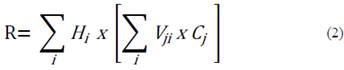
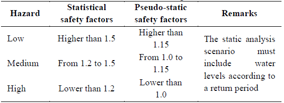
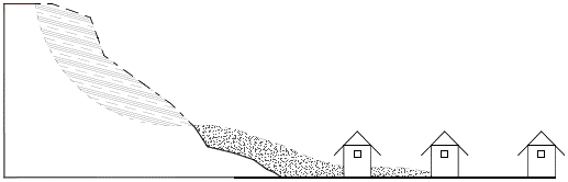
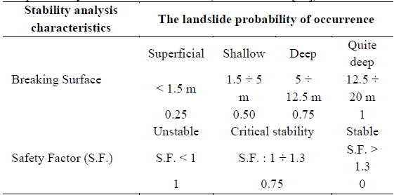
Deterministic methods allow to calculate probability based on a stability analysis through which the most probable rupture surfaces and their corresponding safety factors are obtained. These results allow the hazard zoning, as it is shown in Fig. 2, which, as mentioned in [16], can be a high, medium or no threat.
Although an international standard to classify and to assess hazard is not recognized so far, the implementation of three classification scales is advised (Table 1), which should not drive to a subjective zoning but to the outlining of a probability range [15].
Assessing landslide hazard requires an estimation of the probability of occurrence of dangerous events, for which the following definitions can be used:
P(H) is the probability of occurrence of a specific hazardous landslide.
P(S) is the spatial probability that estimates landslide potential to impact the zone occupied by a specific element.
P(T) is the temporal probability that estimates landslide potential to impact a moving element, such as a vehicle in motion passing by the impacted zone at the exact moment when an event occurs. If the element is fixed, it is considered P(T) = 1.
These are conditional probabilities, that being written in the form P(S:H), express the probability that a specific dangerous landslide occurs and impacts the exposed elements, which causes a spatial effect [17] (Fig. 3).
4. Vulnerability analysis and assessment
Vulnerability is the degree of loss or destruction of a certain element or a group of elements at risk, as a result coming out from a natural phenomenon that occurs with a certain magnitude [4].
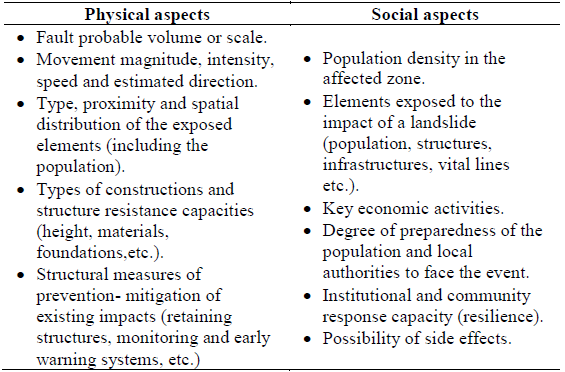
Analyzing and assessing landslide vulnerability implies to study and to know distinct physical and social aspects linked to the phenomenon and its impact on the exposed elements (Table 2).
Table 2 Physical and social aspects to be considered in vulnerability analysis and assessment.
Source: The authors.
Vulnerability is expressed on a 0-1 scale and depends mainly on the exposure of the analyzed element to the hazard.
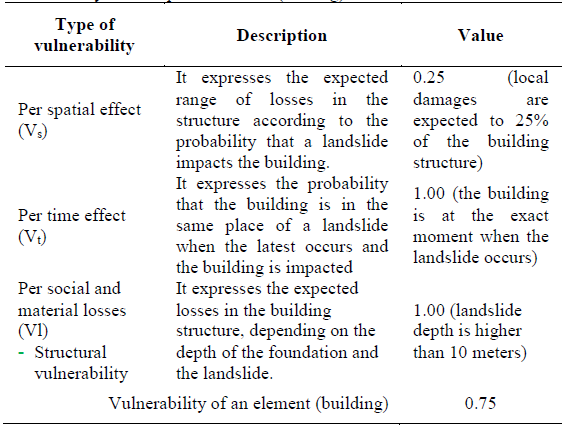
On the purpose of easing analysis and assessment processes, landslide vulnerability can be divided into three groups of vulnerability that are expressed through the following equation

Where:
Vs = vulnerability caused by spatial effect. Its value depends on the probability that a landslide impacts the analyzed exposed element and and damage to its structure.
Vt = vulnerability caused by time effect. It refers to the probability that whether the analyzed exposed elements are (or not) on the place where landslide occurs. 1 is considered for motionless elements into jeopardy.
Vl = vulnerability caused by social and material loss. It depends on the probability of losses in the analyzed exposed element, if this is impacted by the landslide. Loss may arise within the following fields: social or human, structural, road cuts, environmental and economic.
Several authors recommend indices to assess distinct types of vulnerability: Imiriland (2007) [18], recommends physical, social or human, and environmental vulnerability values to the impact of landslides, according to the expected loss range; as well, it proposes economic vulnerability indices because of a road block caused by a landslide. Finlay et al, (1997), [19], recommend landslide vulnerability values of a person (in open area, in vehicle and in a building) in the city of Hong Kong. On the other hand, Ragozin & Tikhvinsky (2000) [20], proposed tentative landslide vulnerability values for structures, according to its foundation depth.
Element vulnerability is conditional in the exposed elements at the precise moment when landslide occurs (temporal effect). It is written as V(L:T) and expresses landslides’ (L) dependency on the moment it occurs (temporary, T). In practice, this means that landslide vulnerability can vary from one moment to another.
4.2. Landslide consequences
The consequence of a landslide (CL) on the exposed elements includes the consideration of spatial probability P(S:H), temporary probability P(T:S) and vulnerability (L:T). This is expressed as it follows:

When a dangerous landslide occurs, consequences on elements with a certain vulnerability will be different according to spatial probability P(S:H) and temporary probability P(T:S). This means that losses or damages depend on whether the element under study is (or not) on the landslide-impacted place at the exact moment when it occurs.
In a practical sense, when we suppose that a landslide will cause damage or losses on the exposed element, because the latest is located on the place where the impact will take place and is found at the precise moment of the oncoming disaster, P(S:H) = P(T:S) = 1 is met, and equation (6) is reduced to:

5. Risk assessment methodology
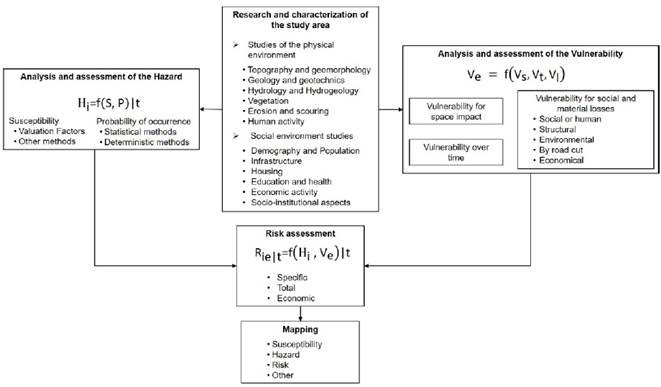
Taking into consideration the aspects above reviewed, a general methodology to assess landslide risk in slopes and hillsides is proposed, as it is shown in Fig. 4. This methodology is made up of the following stages:
a) Research and characterization of the zone under study. This stage includes:
Topography and geomorphology.
Geology and geotechnical.
Hydrology and hydrogeology.
Vegetation.
Erosion and undermining.
Human activity.
Demography and population.
Infrastructure.
Housing.
Education and health.
Economic activity.
Socio-institutional aspects.
b) Hazard analysis and assessment depending on the susceptibility and the probability of occurrence of a landslide.
Susceptibility analysis and assessment by means of valuation factors
Determination of the probability of landslide occurrence by statistical and deterministic methods.
c) Vulnerability analysis and assessment of the exposed elements and their components: spatial, in time and for social and material losses.
d) Risk assessment. Specific, total and economic risk can be assessed based on the study objectives and scope
e) Elaboration of maps (susceptibility, hazard and risk).
Fig. 4 shows a general diagram with the proposed methodology.
6. Application in a real case
Below is a real case of analysis and assessment of landslide risk, in an urban slope.
6.1. Site description and problem presentation
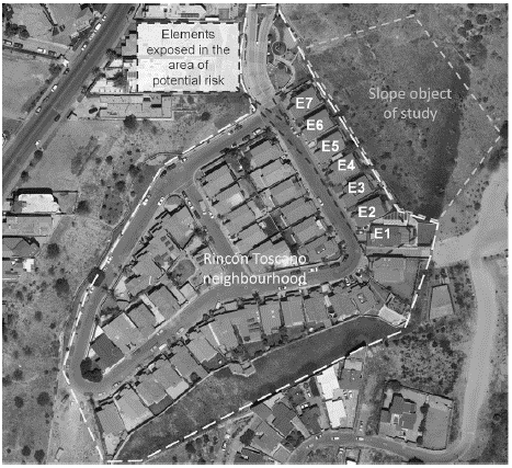
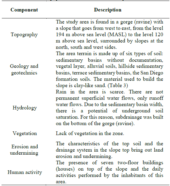
The slope under study is in the northeast sector of the Rincon Toscano residential area, in the City of Tijuana, Baja California, Mexico. The material used to fill in a gorge and build the great platform on which the houses of the residential area were built, created an embankment slope of 35 meters height that was ruled by the following dimensions: 1,75 meters horizontal and 1.00 meter vertical, which produces an inclination of 30°.
At the end of 2015, inhabitants of the houses located on the top of the slope notified the presence of cracks on the terrain and on the structures. After having conducted several studies, it was concluded that those pathologies were caused by water filtration and moistures, due to a fault in the rain drainage system.
After having repaired the fault, and as part of a set of measures to monitor the case, the construction firm of the residential area decided to conduct a landslide risk assessment on the exposed elements (7 houses).
Fig. 5 shows the slope under study and the location of the exposed elements.
6.2. Physical and social characterization of the site
6.2.1.Physical environment
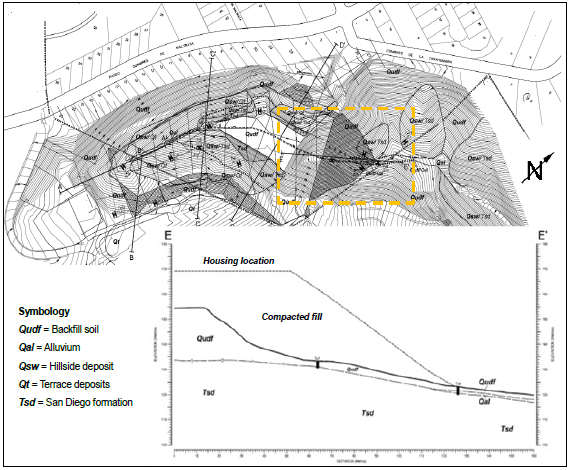
The studies conducted before and after the residential area construction allowed to gather topographical, geological and geotechnical data about the slope. Fig. 6 shows the topography of the zone where the slope is, as well as a geological and geotechnical profile of the latest.
Source: The authors.
Figure 6 Topography of the area and geological - geotechnical profile of the slope.
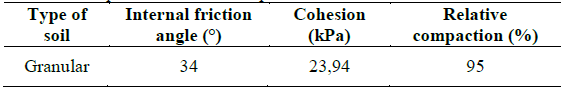
Table 3 shows the terrain parameters with which the slope was built.
Other characteristics of the physical environment obtained from previous studies are shown in Table 4.
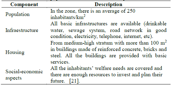
6.2.2. Social environment
In Table 5, social environment characteristics in the study area are shown.
6.3. Hazard analysis and assessment
6.3.1. The probability of landslide occurrence
Statistical methods were not used given that the slope under study is part of the structural sedimentary basin that was specifically designed for this urbanization project and there are no records on historical landslides in similar constructions.
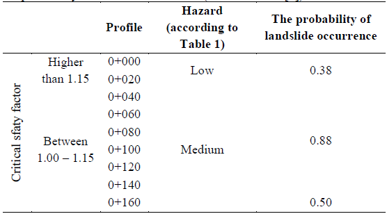
To calculate the probability of landslide occurrence by using deterministic methods, 9 profiles located at 20 m intervals (from 0+000 to 0+160) were considered, as it is shown in Fig. 7.
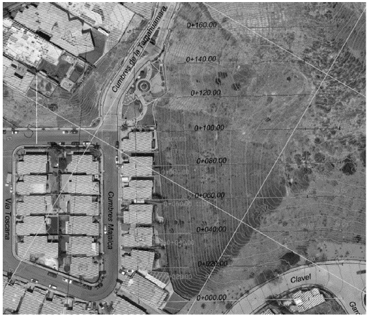
Table 6 shows the results of the stability analysis by considering seismic acceleration effects (30 % of gravity) and 25 % of terrain saturation.
Table 6 Stability analysis results of the slope under study.
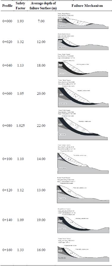
Note: In the failure mechanism, the area one represents the potentially unstable mass and the dark area represents the progressive failure zone.
Source: The authors.
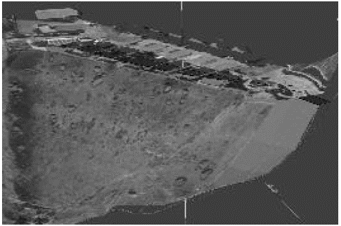
Fig. 8 shows the three-dimensional model of the slope where potentially unstable and progressive fault zones are observed.
The probability of landslide occurrence was obtained by considering the stability analysis results for each one of the profiles, using the valuation factors proposed by Cuanalo, Oliva & González (2007) [13], which is presented in Table 7.
Table 7 The probability of landslide occurrence (modified from [13]).
Note. Total probability is the average of the factors corresponding to a breaking surface and S.F.
Source: The authors.
Table 8 shows the recommended scales for hazard zoning, according to safety factors (Table 1) and the probability of landslide occurrence associated to such factors, which were obtained as Table 7 indicates.
6.3.2. Susceptibility
Slope susceptibility to landslides was obtained by considering factors that assess the influence of parameters dismissed by the deterministic methods used to estimate the probability of landslide occurrence [13,22], (Table 9).
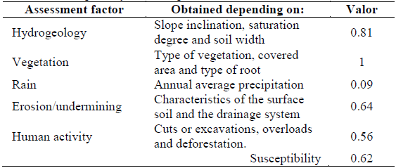
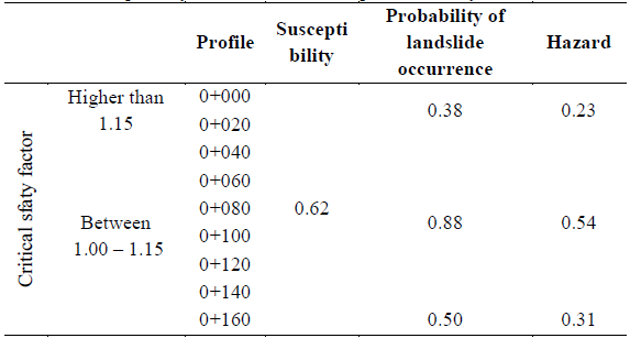
Table 10 shows the analysis results of landslide susceptibility and the hazard assessment, as a result of the interaction between susceptibility and the probability of landslide occurrence.
6.4. Vulnerability analysis and assessment
To analyze and to assess vulnerability, it was considered that the elements exposed to the landslide hazard are the (7) houses built on top of the slope under study, in which the expected degree of loss and destruction as a result of the occurrence of a landslide, was estimated by taking as a basis the fault model and criteria that are showed in Table 11.
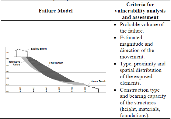
The results of the stability analysis indicate that the fault volume, as well as the magnitude and estimated direction of the movement of the potentially unstable soil mass are similar in the nine (9) analyzed profiles. On the other hand, all seven (7) buildings are located at the same distance from the edge of the slope and have similar constructive dimensions and characteristics (height, materials and foundations).
The above-mentioned criteria and remarks, as well as the evaluation of the current state of the buildings, allowed to obtain the vulnerability values of an exposed element (building), as shown in Table 12.
6.5. Vulnerability analysis and assessment
Based on the landslide hazard of the slope under study and the vulnerability of the exposed elements, the specific risk of the buildings located in the top of the slope was determined (Table 13) [23].
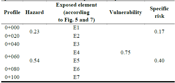
Fig. 9 shows the landslide zoning of the specific risk in the slope under study.
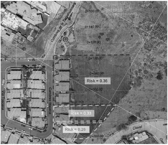
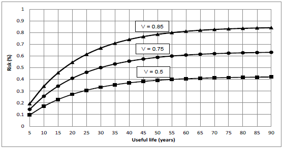
Fig. 10 shows risk behavior on the exposed elements with higher hazard (E3, E4, E5, E6 y E7) depending on vulnerability (V) and considering a 20-year return period.
7. Conclusions
In this paper, a comprehensive approach of the landslide risk is presented, and an assessment methodology applicable to this approach is proposed.
Landslide hazard is calculated by considering, not only the result of deterministic methods for stability analysis but also of a susceptibility analysis of the terrain in which conditioning and triggering factors of instability are considered, which influence in the calculation formulations of safety factors. On the other hand, it is proposed to analyze vulnerability considering spatial and temporary components of potential landslides, their relationship with the physical and social aspects of the exposed elements; and the impact that an event occurrence might produce in terms of social and material losses.
The application of the methodology on the urban slope at the city of Tijuana allowed to assess risk on the exposed elements and their behavior over time for different scenarios, and to identify conditioning and triggering factors of instability and their levels of influence.
To analyze and to assess risk by means of the proposed comprehensive risk approach, considerably reduces uncertainty in projects where slope and hillside stability has a key role; so it is a valuable tool in the hands of planners and authorities to prevent disastrous events.


