


 Inglés (pdf)
 Articulo en XML
 Referencias del artículo
 Enviar articulo por email
 Citado por SciELO
  Citado por Google
  Similares en
SciELO
Similares en
SciELO  Similares en Google
 Permalink
1. Introduction
Colombia is a country rich in wetlands [1]. It is estimated that over 20 million hectares of Colombian territory are covered by wetlands [2,3]. These are understood as “ecosystems that, due to geomorphological and hydrological conditions, allow the accumulation of water, temporarily or permanently, and give rise to a characteristic type of soil, and/or organisms adapted to these conditions”. However, [4] estimate that Colombia possesses closer to 30.8 million hectares of wetlands. There are a variety of types of wetlands in the tropical Andes, which are identified by multiple regional names, in Spanish, including “zanjón, ronda, zapal, poza, laguna, jagüey, firmal, ciénaga, charca, caño, bijagual, bajo, aningal, and acequia”. All of these are wetlands, and therefore form part of our water patrimony, and are not mere resources. They must be protected, as they perform regulation functions such as flood control, aquifer recharge, improve water quality and constitute zones of erosion control. Also, wetlands perform ecosystem services as contribute to the promotion of biological connectivity, favor the bird migration, and provide housing for mammals, amphibians, reptiles, birds, and insects in riparian vegetation, and aquatic invertebrates, phytoplankton, perifiton, zooplankton, arthropods, and fish in its water body [4].
Wetlands accumulate a certain amount of water, whether from underground or surface sources. The minimum parameters for wetland classification are climatic conditions, humidity conditions which are capable of favoring water accumulation and storage, and most importantly, it must have associated ecosystems and a water depth of less than six meters [5]. The following is a complete description of wetlands in accordance with the definitions of different authors:
“Variety of habitats such as swamps, peat bogs, floodplains, rivers and lakes, and coastal areas such as marshes, mangroves and seagrass beds, but also coral reefs and other marine areas whose depth at low tide does not exceed six meters, as well as artificial wetlands such as wastewater treatment ponds and reservoirs” [5].
“Ecosystems with dependence on aquatic regimes, natural or artificial, permanent or temporary, lentic or lotic, sweet or salty, including marine extensions to the posterior limit of phanerogams or reefs, or in their absence, up to six meters deep in tide low” [6].
“Wetlands are areas where water is the main controlling element of the environment, and the plant and animal life associated with it. These ecosystems occur in those areas where the waters are located on or near the land surface, or where the soils are covered by shallow water.” [7].
“Wetlands are lands transitional between terrestrial and aquatic systems, where the water table is usually at or near the surface, or the land is covered by shallow water. For purposes of this classification, wetlands must have one or more of the following three attributes: (1) at least periodically, the land supports predominantly hydrophytes; 2) The substrate is predominantly undrained hydric soil; and 3) The substrate is non-soil and is saturated with water or covered by shallow water at some time during the growing season of each year” [8].
“… those areas that are inundated or saturated by surface or ground water with a frequency sufficient to support, and under normal circumstances does or would support, a prevalence of vegetative or aquatic life that requires saturated or seasonally saturated soil conditions for growth and reproduction. Wetlands generally include swamps, marshes, river overflows, mud, flats, and natural ponds” [9].
It may be concluded that several topography and climate scenarios produce water accumulation and retention, and in many aspects, wetlands occur due to the presence and/or exchange of groundwater [10,11]. The functions of wetlands may be simplified as follows: they provide a source of habitat, a hydrological exchange, and water quality moderation. However, not all wetlands perform all of these functions, nor do they perform all of said functions equally well [12]. They may include natural or artificial regimes, and they be permanent or temporary.
There are many definitions of wetlands [13], as shown above, but their utility is most important. Therefore, this investigation focuses on the three main exchanges of the hydrological function of non-tidal wetlands, distinguishing exchanges of groundwater, surface water, and atmospheric water [14], and observing that some wetlands, such as those located in the tropical mountain valley in the midst of the Magdalena basin, Colombia, are governed by these three types of water exchange [15-18].
For wetland determination, various authors, such as [19] who have proposed the exclusive use of remote sensing techniques, [20] define biophysical and socio-environmental criteria, which integrate complex systems that interact dynamically and propose delimitation as a process integral to ecosystem management. This considers criteria for the identification of a wetland’s functional limit and for analysis of implications and decision making. These publications focus on delimiting large wetlands, as in [21], which uses Geographical Information Systems GIS in agricultural contexts. Environmental entities in Colombia, such as the Alexander Von Humboldt Institute for Biological Research, propose a 50-category classification, ranging from purely geomorphological values, such as depth, to wetlands that include detailed vegetation and hydrological qualities [4].
Berlanga-Robles, Ruiz Luna & De Lanza Espino [22] performed a classification of Mexican wetlands and presented a summary of their classifications in 18 different parts of the world, highlighting that the Cowardin et al.’s classification [8] may be applied to wetlands greater than 2 m deep in the United States, and that secretariat of the RAMSAR convention [5] proposes the inclusion of geomorphological, hydrological, and vegetation criteria. Most classifications are based on the two above-mentioned methodologies. For example, Mediterranean area, Costa Rica, and South Africa employ proposals based on the methodology of [8], Eastern Europe uses the classification proposed by the European Union programs CORINE (Coordination of Information on the Environment), BIOTOPES, and EUNI (Habitats Classification European Nature Information System), based on the RAMSAR classification [5], as do Asia, Australia, and New Zealand. The Canadian classification is based on genetic, geomorphological, and physiognomic types [22].
The Ministry of the Environment of Colombia [2], has posited strategies for wetland conservation and sustainable use, by way of a five-level hierarchical system which separates anthropogenic and artificial wetlands and considers aspects of the wetlands’ physiognomy, soil characteristics, vegetation, and the social aspects that sustain them.
Those investigations which have been performed in Colombia to determine the existence of bodies of water have focused mainly on wetland verification and delimitation in the Bogotá savanna and the study of mangroves on the coasts. However, in the area near the Yaporogos Lagoon, a study has been found for the Caracolizal wetland in the municipality of Melgar, in which all of its components were examined, and an environmental management plan was formulated to aid conservation efforts [13]. But However, each case is unique, owing to the information available, scale of work, and purpose of wetland delimitation. In the case of the present study, this is to propose a methodology which would provide a baseline for Colombian territorial planning, which, in turn, would permit the protection of small seasonal wetlands.
The Convention on Wetlands of International Importance, especially as Waterfowl Habitat [5], the Convention on Biological Diversity, signed in Rio de Janeiro in 1992, and the Political Constitution of Colombia of 1991 in articles 79 and 80, protect the wetlands, so as to guarantee citizens’ collective right to the environment [13].
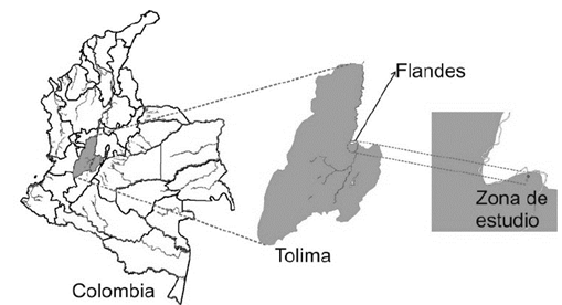
Below, the methodology employed for a small-scale wetland is presented, through the Yaporogos Lagoon case study in Flanders, Tolima, where the community proposed the delimitation of a small wetland, to be conserved and protected, which would prevent its urbanization.
2. Materials and methods
The proposed methodology corresponds to field visits for the collection of primary information, including topography and geoelectric surveys. Visits to the Flandes mayoral office, the Regional Autonomous Corporation - CORTOLIMA, the Regional Autonomous Corporation of Cundinamarca-CAR, and the governorate of Tolima allowed for the obtention of the available secondary information, in terms of social and biophysical territorial data: 1) Extraction of the Digital Elevation Model, DEM [10], with which it was possible to carry out the topographic analysis, for determination of low areas and the drainage network, and obtain the topographic index which indicates the saturated areas of the terrain, 2) Regarding toponymy, old plans from the Agustin Codazzi Geographic Institute (IGAC in Spanish) were revised. Given their 1: 25,000 scale, the body of water did not appear, 3) Analysis of the local climate in the city Girardot, which neighbors Flandes [23], 4) Analysis of territorial planning tools, in the case of the municipality of Flandes, these corresponded to the Territorial Planning Scheme, EOT in Spanish [24], 5) Analysis of the urban expansion in the area, through analysis of the images available on Google Earth [25], 6) Geological studies and geomorphological analysis of the area [23,26], 7) Geophysical studies, based on Vertical Electrical Probes, VEP [27], and 8) Biological sampling, both of the soil and water [27].
All of this information permits a joint analysis, which determines whether or not a wetland exists, as the seasonal water body is consolidated and delimited by each of these aspects.
3. Study zone
The study area was located in the urban area of Flandes, a town in the central eastern sector of the Tolima department in Colombia. More specifically, it was located on the eastern side of town, using the main park and the vicinity of the road that connects to the Vila-Santiago airport as references, it was located in the lot adjacent to the Puerto Bahía 2 urbanization. The sector is surrounded by the Puerto Bahía 1 and 2 residential complexes, and is near the San Francisco and Puerto Mediterráneo farms. On the hill to the north, the Flandes water tower may be observed, which is located in protection zone. In Fig. 1, the location of the study area, which covers an area of approximately one hectare, is clearly presented.
4. Results and discussion
The investigation results indicate the presence of a wetland in the study area, which is explained in greater detail below.
4.1. Information extracted from the DEM
A topographical analysis of the area under study was carried out with topographic precision equipment, which was subsequently revised, through use of Digital Elevation Models DEM taken from the US Geological Survey in the United States of America [10]. There is evidence, in aerial photographs and IGAC cartography, that, in some periods, water bodies appear perfectly delimited, and in others, they disappear, which describes the seasonality of the wetland.
Toponymy refers to the study of proper names used by locals. In this case, because there is new urban development, very few people have knowledge of the area. A number of seniors, however, do have knowledge of the Yaporogos Lagoon. Another reference to this ignorance was found on the IGAC topographic maps from 2005, which use a 1:25,000 scale. Therein, no reference was made to the Yaporogos Lagoon, thus this point was inconclusive, given the scale of the wetland.
The topography of the area was naturally lower than the surrounding areas, a fact which was validated in the field by topographic precision equipment and by means of DEM analysis, which used the topographic index [28]. This facilitates the accumulation of subsurface water during wet seasons. It also showed the existence of natural drainage, which leads surface runoff water to the area in which the body of water that was previously modified was relocated. Such drainage has been used by the owners of the nearby lots in both the past and present to drain water. It has been rerouted, in accordance with the needs of the neighboring buildings. However, it still fulfills its hydrological purpose, which is to drain water towards the Magdalena River, located downstream.
4.2. Climatology
According to the plan for the management of the Magdalena River basin - eastern slope of the Cundinamarca department [23], the study area is characterized by a warm, semiarid climate, according to the Caldas-Lang classification, with a bimodal rainfall regime, associated with the Inter-Tropical Confluence Zone, ITCZ [29], where the first wet season is the most intense, and which occurs from the end of April to June. The second occurs from September to November. Monthly minimums occur in January and July, amounting to approximately 45 mm of monthly rain, with an average annual rainfall of approximately 1,400 mm [23].
The average temperature in the region is 28 ° C, with minimal variations throughout the year. The difference in thermal gradient between the warmest and coldest months is 3 ° C. The relative humidity averages 65% monthly, and behaves analogously to precipitation, with maximums in rainy seasons. Meanwhile, the potential of evapotranspiration presents a tendency opposite the rains, which generates a water deficit in the summer seasons.
The region has dry tropical forest type vegetation, but in the study area, the bush and shrub areas predominate. Said shrubby vegetation blooms during rainy season and loses its foliage during the dry period, a behavior which responds to climatic variability and the strong anthropic intervention of livestock and agriculture activities [23].
4.3. Territorial planning tools
According to the Territorial Ordinance Scheme of the Municipality of Flanders, this area has been declared an area of municipal interest and influence [24, p. 60], extending to the top of the hill with the municipal water tank, joining both urban and rural areas. The present document mentions that the water system in the area is comprised of lagoons, of which one is “on the lot where the water tanks are located,” and the other at the back of the Libertador neighborhood. They are not maintained, nor do they have management plans for effectively use as recreational elements” [24, pp.32].
4.4. Urban evolution in the zone
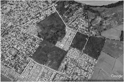
Old Agustín Codazzi Geographical Institute (IGAC) images and those of Google Earth permit the location of the water mirror, called Yaporogos Lagoon by the community. There, additionally, there is a channel flowing SW-NE and an outcropped water mirror. In order to carry out this analysis, images were taken from Google Earth [25], the first of which was captured on December 31, 1969, as shown in Fig. 2. Although its resolution is low, when focused on the municipality, one may ovserve that, at the time, the study area at the Yaporogos Lagoon was not surrounded by buildings. An aerial photograph of the year 2012, which is presented in Fig. 3, shows the area of interest in greater detail, and indicates a significant urban change, with a considerable increase in new construction. In the 2012 image, abundant vegetation is observed, while in Fig. 4, from 2015, the vegetation is shown to be considerably reduced by burning in the area, followed by the sprouting of pastures and ground vegetation, which is observed in the present, as indicated in Fig. 5 [25].
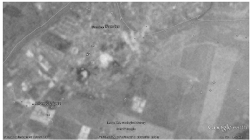
Source: Adaprted from Google Earth.
Figure 2 Aerial photograph from December 31, 1969, at an elevation of 4.17 km, approximately.
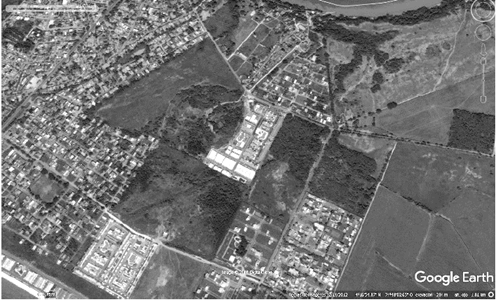
Source: Adaprted from Google Earth.
Figure 3 Aerial photograph from February 14, 2012, at an elevation of 284 m, approximately.
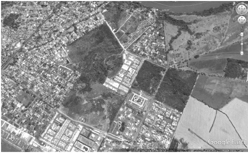
Source: Adaprted from Google Earth.
Figure 4 Aerial photograph from July 23, 2015, at an elevation of 284 m, approximately.
4.5. Geology and geomorphology
The Magdalena River valley, at the height of the Tolima and Cundinamarca departments, is characterized by limestone and sandstone strata. Additionally, multiple eruptions of the Machín and Tolima volcanoes have deposited pyroclastic flows on the banks of the Magdalena River [23].
In the study zone, sedimentary rocks from the Honda group (Ngh), as well as “Abanico de Espinal” (Qae) discordant volcanoclastic deposits may be identified, as documented in the Colombian geological map 1:100.000 from the IGAC, created in 2013. The Honda group is comprised of typical, greenish gray sandstone that was established in the San Antonio Mountain Range, east of the town of Honda [30]. In the study area, the Honda group emerges southwest of Girardot in the Flandes area.
The range of Espinal (Qae), originated with the contribution of the Cerro Machín volcano, with a high volcanic content and finer material from the Quaternary Age. This fan, in the flat area between Flandes and Espinal, is used for agriculture, with sporadic levels of gravel, high porosity, and hydraulic conductivity. These deposits, with their high bearing capacities, are also exploited as building materials [31].
Geomorphologically, it is identified as a discharge zone for the Central Mountain Range, a superficial accumulation that depends on the physical properties of said deposits and lithological outcropping units. In the study area, the unit called the Honda group was identified, whose lithological composition favors accumulation. Thus, it may be identified as a potential aquifer area. Additionally, its undulated surface favors the accumulation of water bodies dependent on lithology and climate. These processes led to the formation of fluvial system geoforms. For previous geoforms, the composition of the sediments varies significantly, aspects which may be analyzed for the reconstruction of accumulation environments.
4.6. Water quality
The chemical composition of continental water varies widely, mainly due to the lithological variability of the basin or lake, climate, vegetation, and environmental factors. Anthropogenic factors are also important because they directly affect soil erosion, agricultural-livestock activities, irrigation, as well as the negative impact in the area destined for waste dumping and urbanization. All of these tend toward the accumulation and concentration of compounds that, in their organic degradation process, mineral or ionic substances permeate the Magdalena River [32].
Algae are commonly used in the biological characterization of the ecosystem, determination of the healthiness of a water resource, and its subsequent use for different applications [33]. Diversity, the combination of morphological, physiological, and reproductive characteristics make algae important diagnostic organisms, suitable for use and application in ecosystem analysis and evolution [34].
Paleoecological, paleolimnological, paleoenvironmental, and paleoclimatic research use diatoms as indicators which provide valuable information, due to the sensitivity of this group of algae to environmental changes, including valve preservation in lake sediments [35]. Additionally, paleolimnological conditions reflect local environmental conditions, specifically precipitation and evaporation, two of the most important climatic factors [36].
4.7. Geoelectrical surveys
Geophysical methods are based on the measurement of certain physical properties of the materials contained in the earth's crust: density, magnetic field, electrical conductivity, speed of transmission of elastic waves, etc. The interpretation of these measurements, based on the contrasts between, and anomalies observed, allow for preparation of models with the characteristics of the subsoil and its spatial distribution. Surface electrical studies represent a method of analyzing geomaterials in terms of their electrical properties. Of these, resistivity has been related to petrophysical parameters such as porosity and the degree of saturation. The acquisition of field data may be carried out with electrode configurations, which can vary in their arrangement, and that strictly depend on the object upon which the scan is performed. A common configuration in these electrical methods is the Vertical Electrical Probe (VEP), as it is possible to produce one-dimensional models that correspond to discrete points on the surface [27].
In this study, electrical surface studies were carried out, using a method of geomaterial analysis, in terms of its electrical properties, which are subsequently compared to petrophysical parameters, such as porosity and degree of saturation. The configuration employed was Vertical Electrical Sounding (VES), whereby geomaterial resistivity values were found in the area of interest from 5Ωm to 34Ωm. This variation in resistivity values is due to the humidity and salts present. The resistivity is characteristic of fine geomaterials (clays - limes) that, in saturated conditions, present resistivity values ranging between 5 Ωm and 20Ωm, and in unsaturated conditions, between 20Ωm and 40Ωm. This, in turn, depends on the concentration of salt present in the water which saturates the geomaterial.
4.8. Biotic samples
A complete study requires a biological analysis, in order to establish the existence of certain ecosystemic relationships that can define the existence of a wetland. They usually make use of certain ecological attributes, such as wealth, abundance, and diversity, among others, of the biological communities. For the present study, the community of phytoplankton algae in water and soil diatoms were used, and whose determinations were made by the taxonomic gender category, which is based on the works and taxonomic guides of [37-43] and the http://www.algaebase.org/ global database.
The purpose of the biological tests was initially to extract a nucleus from the deepest zone, where a depression in the ground had been detected, in order to establish whether there was evolution in the aquatic ecosystem, through the use of diatoms (Bacillariphyta), via the previously described lithological profile. However, when the area studied was visited, it was found to be flooded, and so a phytoplankton sample was collected, in order to glimpse the water quality of the flooded area by way of these organisms. Twenty-one morphotypes from 15 families, 11 orders, six classes, and five phytoplankton divisions were found. The Bacillariophyta division (diatoms) contributed 29% of the morphotype total (6). Additionally, five (24%) Chlorophyta, and four (19%) Charophyta morphotypes were observed (the last two are green algae), Cyanobacteria contributed four morphotypes (19%), and the Euglenophyta division represented 10% with two morphotypes.
Diatoms (Bacillariophyceae) are unicellular, free-living microscopic algae, although they also form colonies surrounded by mucilage and filamentous individuals [44]. They are observed in all types of habitats, where the light, temperature and chemical conditions are favorable for their growth, and are distributed in all latitudes and longitudes in the world. Thus, they are present in rivers, estuaries, lakes, and marine environments located in various substrates, as well as in humid, cold, and hot springs [45]. The fossil record indicates that diatoms were already a specialized group in the early Cretaceous period [46]. In the Yaporogos Lagoon, it was observed that, although diatoms provided the greatest number of taxa, they were not predominant.
In the phytoplankton sample (extracted from the water) it was found that the taxa with the most predominance was cyanobacteria, Anabaena genus. Species in this genus are planktonic, and sometimes they form water flowers (mainly of the Dolichospermum subgroup) or mats that cover different substrates, aquatic plants, submerged forests, stones, etc. Several species grow benthic or in soils, and several are known saline (brackish) biotopes. Many species have limited geographical distribution areas, but the genus is extensive and common. Some of these form dense superficial blooms, and others register as toxic [39,47].
As for the soil samples, the Hantzschia aff. Amphioxys, Navicula aff. mutica, Sellaphora sp. and Fragilaria sp diatoms were present. On the one hand Hantzschia amphioxys is a cosmopolitan species that is favored in periodically dry habitats, including soils and cracks in rocks, which extends to a wide variety of rivers, and probably washed away by soils. It is also very characteristic of temporary aquatic habitats [43]. On the other hand, Navicula mutica is also a species distributed throughout the world, and is quite common in brackish conditions and in waters prone to desiccation [43]. The ecological characteristics that describe these two species explain their presence in the nuclei far from the flooded area.
While the Fragilaria sp. and Sellaphora genera, with affinity to the pupula species, are typical of wetlands, as is Fragilaria sp. It is abundant in lake plankton, is a taxon that is considered to have been introduced by human activities, and Sellaphora pupula is a species that is found in a wide spectrum of waters rich in electrolytes, with some populations that are in heavily polluted conditions. These situations explain the reasons that these two species were only recorded within the lithological sample extracted from the water mirror, and likewise sustain the conclusion of the liquid sample reading, as it indicates the degree of contamination to which this body of water is exposed.
5. Conclusions and recommendations
The complexity of wetlands in their geoforms, biodiversity, water quantity and quality, types of soils and land uses, and their relationship with the community make it essential to estimate and delimit them with a better scale than that available at the Institute of Biological Research Alexander von Humboldt. Its delimitation must be included in planning tools, such as Municipality Management Plans, Watershed Management Plans, Environmental Management Plans, (PMA in Spanish) and/or in any other territorial foresight or planning entity.
This article presents a methodology which determines the existence of small-scale wetlands in areas of urban expansion, in order to determine whether the existence of wetlands compromises any ecosystem of interest to the community. This methodology must be implemented in the planning tools of Colombian municipalities, as developers are constantly pressuring local and regional governments to modify land use in these areas. Because they are stationary wetlands that only appear in rainy seasons, developers take advantage of intense summer periods to request land use changes. However, the elimination of said wetlands causes flooding, loss of biota, loss of biological connectivity, water pollution, decrease in aquifer recharge, and land instability, which leads to important socio-environmental problems and ecosystemic changes.
Wetland areas may be identified through use of the methodology proposed in this article, as in Colombia, intensive urbanization in wetland areas is common, under the premise of lack of studies or procedures to determine whether they are really wetlands or are usable areas for urban sprawl. Therefore, it is shown that, in the case of the Yaporogos wetland in Flanders, in the Tolima department of Colombia, it was possible to determine the existence of the wetland using: 1) topographic methods, based on primary information taken in the field and the use of the topographic index, using the MED, 2) geological analysis with vertical electric soundings that help to expose aquifer lenses, 3) geomorphological analysis of the area, 4) review of the urban development in the area and 5) biological tests, by way of the ground diatoms and water periphyton.
The results indicate that the Yaporogos Lagoon existed many years ago, and was used to provide water to livestock, that it is a natural seasonal wetland that was moved south for the convenience of urbanization and construction, and whose feeder drainage channel was redirected, such that, at present, the water that runs through this natural channel borders the eastern side of the development, in a modification of its original course. Despite this movement, the wetland serves to restrain the high water flows produced in the rainy season, because the topography and geology of the site stimulate water accumulation and the presence of aquatic ecosystems associated with the area. This study sought to highlight wetland delimitation processes, which consider the performance of ecosystemic functions to be of greater importance than the exact location of a wetland. It is expected that, with these results, both the community and CORTOLIMA may implement the measures necessary for the recovery and conservation of this wetland.

