


 English (pdf)
 Article in xml format
 Article references
 Send this article by e-mail
 Cited by SciELO
  Cited by Google
  Similars in
SciELO
Similars in
SciELO  Similars in Google
 Permalink
1. Introduction
The socio-ecosystems present in the rural water supply watershed in the Colombian Andes are complex systems that integrate the local ecosystem with social, cultural, organizational and technical components to provide drinking water services to local communities [2]. These socio-ecosystems present characteristics of fuzzy systems with different causalities among the factors that affect their problems. Developing countries are characterized by their high vulnerability to climate variability (CV) and climate change (CC), with ecosystems and water supply areas prone to facing changes due to this phenomenon [12].
In the Colombian Andean rural area, water services are provided by community organizations or small public utilities [4]. Hydrological variability along with climate change introduces uncertainty in local water management, which increases the vulnerability of these communities. In Colombia, climate forecasts indicate that the climate phenomenon is increasing the risk of events such as floods, extreme droughts and landslides, for example, the floods that occurred between 2010 and 2011 as one of the worst in the country's history that left 352 dead, about 3 million people affected, 12,000 homes destroyed, more than 1.3 million hectares of crops destroyed and more than 370,000 animals killed [4]. These impacts are a sign that many sectors and regions are not well adapted to climate variability and yours trends.
The conceptual and operative models are best understood as a simplified representation of a natural system in which the objectives are: to understand the studied system, to predict future events, to understand the impact of events that have not yet happened, to understand the impact of human behaviours, to understand observations and to develop and test theories [13,17,19]. Modelling based on analysing socio-ecological dynamics allows for understanding, i) the interactions between relevant actors (characterized by their interests, capacities, and strategies), ii) the dynamics of the ecosystems, iii) how the actors influence the ecosystems through actions and practices, and iv) how the actors are affected by the economic and social results of their actions and by the evolution of ecosystem services [5,7].
To improve the understanding of these interactions between human beings and nature, and with the objective of providing decision makers with tools for the prioritization of actions and measures that reduce vulnerability to CV, this study was conducted in a watershed in the Andean in Colombia, where shortages cause conflicts over water use and increased the pressures on water resources, thereby affecting the regulation of water quality and quantity [3]. For this reason, this study area is considered a typical case for applying the diffuse cognitive maps, given that most Colombian rural contexts present similar problems [16].
Diffuse cognitive maps are diffuse graphical structures that represent causal reasoning and consider different degrees of causality and their influences on the complexity of the systems [8]. The application of fuzzy cognitive maps (FCMs) has increased in the studies of natural systems, especially when there is little information available and the influences can be defined as positive or negative according to the concepts of experts [1]. This maps can be studied with the support of modelling tools that allow an analysis of the factors and their evolution over time. In this study, the iModeler software was used as an available modelling tool, which can be applied quantitatively or qualitatively (existing software to support decision making).
Recognizing that the availability of water varies seasonally and annually, and that the vulnerability of rural communities is increasing to face climate changes, the objective of this article is to analyze the vulnerability to climate variability in a Colombian Andean micro-watershed, through the application of a diffuse cognitive map as a tool for decision making at the rural level.
2. Methodology
2.1. Study case
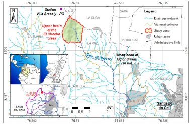
El Chocho stream micro-watershed it is located in rural area northwestern Cali, Colombia (Fig. 1), which supplies 3500 users in the urban area of Golondrinas after passing through a treatment system with Multi-Stage Filtration Technology (FIME). In the micro-watershed, the main uses of the water are domestic, agricultural, livestock-related and for mining located in the middle and lower parts of the watershed. The water supply system is managed by a community-based organization (Utility Company, Golondrinas public services, aqueduct and sewerage utility company - ESAAG) that is legally regulated by State institutions. Recently, the company has reported complaints regarding the provision of drinking water services, which are attributed mainly to the lack of continuity and quality of drinking water. During times of drought, water rationing occurs for up to nine days, causing conflicts over access to water and increasing levels of vulnerability, risk, and poverty.
Source: The Authors.
Figure 1 Geographical location of the upper part of the El Chocho micro-watershed
The hydrological variability that characterizes this area is represented in precipitation changes, for which a previous analysis of this variable was performed. It was found that according to data from 32 years of rainfall records of the Villa Araceli rainfall station (Fig. 1) (1981-2013) [5], the months with the highest rainfall are: April (184 mm), May (163 mm), October (166 mm) and November (160 mm). The months with the lowest rainfall are January (82 mm), February (87 mm), July (61 mm) and August (63 mm).
Based on the results of a previous study based on conceptual modelling using the analysis method of socio-ecological dynamics that was implemented in the upper part of the El Chocho micro-watershed [2], different factors were found that affected the regulation of water quantity and quality, putting the supply at risk. Among these factors, the influences of the CV and the CC are highlighted, which, although they affected the regulation of water, were not the main cause of the shortages. This is because aspects such as institutional fragmentation, lack of advice and institutional support, inadequate use of soil and water, deforestation, erosion, pollution, overexploitation of water resources, excessive use of agrochemicals in agriculture, inadequate farming techniques and conflicts over land tenure were the factors that most exacerbated the water crisis in the area.
2.2. Fuzzy Cognitive Maps (FCMs)
The diffuse cognitive map in the upper part of the El Chocho stream micro-watershed was implemented using the iModeler software that allow your modelling. These models are composed of factors or concepts (C1, C2, ... Cn) represented by figures such as boxes, ovals or triangles. The state vector (a1, a2, ... An) that describes the state of the node Ci, representing the value of the concept, is on a scale of 1 to 100. The factors are represented by their number of influences, which can be positive or negative depending on whether the influence of one factor on another increases or decreases. They are symbolized as arrows with a positive or negative sign. The model offers a graphical form to visualize and analyse the movement and effect of each factor over time, as related to the central factor. The results matrix provides inputs that allows for prioritizing actions during a planning process, decision making, and communication in adaptation processes for the short, medium, and long term.
A diffuse cognitive map was defined for each of the two climatic conditions: high rainfall and low rainfall, and in both cases the central factor was defined as the level of water regulation that depends on the regulation of quality and quantity of water in the El Chocho micro-watershed [2]. Both regulations have positive or negative influences on the regulation of water, which are attributed to the influence and effects exerted by external pressures identified in the micro-watershed. Among them are socio-economic, climatic, productive and technical pressures. Other factors were defined within the complexity of the system and were related by considering the degree of influence of some factors over others through the estimation of weights. The weights were assigned from 1 (weak) to 100 (strong) based on the degree of influence that each of the factors have on a given factor. These weights were established based on the knowledge of the territory and on the results from an analysis of socioecological dynamics that was previously carried out [2].
The allocation of weights was made for different times, as the short term was defined between 2 to 5 years, the medium term between 6 to 10 years and the long term over 10 years, considering the current trend of each of the factors involved in the model. The climatic condition for the allocation of weights was considered, so that for each period the factors of greater weight and influence with respect to the central factor were determined. The results of the modelling were interpreted according to the knowledge matrix, which is a graphical way to visualize and analyse the movement and effect of each factor in time in relation to the central factor. The results matrix provides inputs that allow better planning, decision making and communication during adaptation. The matrix presents the sum of the influences that affect each one of the factors with respect to the central factor as a function of time: short, medium, and long term. On the horizontal axis, the sum of all direct and indirect factors is presented in relation to the central factor (action paths) and on the vertical axis, the variation of the impact with respect to time is presented, where there may be delays in the effect of each factor or an indication is present if the effect is cyclical. For each one of the factors of the model, we have a knowledge matrix in which the influences are presented as points within a quadrant with a certain colour. The matrix has four quadrants in which the analysis of the changes of the influences on the factors is carried out [9]:
Blue quadrant: the factors that reduce the value of their influence and decrease the effect on the central factor in time
Green quadrant: the factors that increase the value of their influence and increase the effect on the central factor in time
Red quadrant: the factors that decrease the value of their influence and increase their effect on the central factor over time
Yellow quadrant: the factors that increase the value of their influence and decrease their effect on the central factor over time
The results of the modelling were input for the formulation and prioritization of adaptation measures necessary to improve the regulation of the studied hydrological services. The capacities of adaptation and resilience of the socio-ecosystems in the face of the CV were also input, thereby diminishing the vulnerability of the rural communities facing the drought.
3. Results and discussion
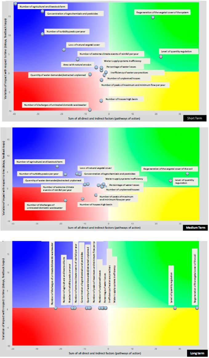
The operative model applied (iModeler software) to the analysis of CV vulnerability in the El Chocho micro-watershed considered the regulation of water quantity and quality as central factors. Fig. 2 presents the analysis system composed of the positive or negative influence of external factors, such as the operation of the Golondrinas water supply system, the productive agricultural and livestock activity of the area, the local culture surrounding water use, demographic growth, human settlements in the upper part of the study area, and the influence of climate variability.
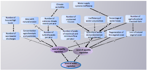
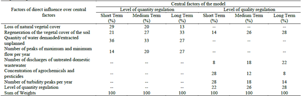
These aspects, in turn, generate other factors that alter the regulation of water, thereby highlighting the turbidity peaks in the water per year, the concentration of agrochemicals and pesticides in the water supply, the peaks of maximum and minimum flow per year, the increasing demand and extraction of unplanned water and, with a positive influence, the natural regeneration of the vegetal cover. Each factor was assigned a weight on the central factor as presented in Table 1.
Table 1 Weights assigned to the factors of direct influence on modelled central factors
Source: The Authors.
3.1. Regulation of the water quantity during high rainfall
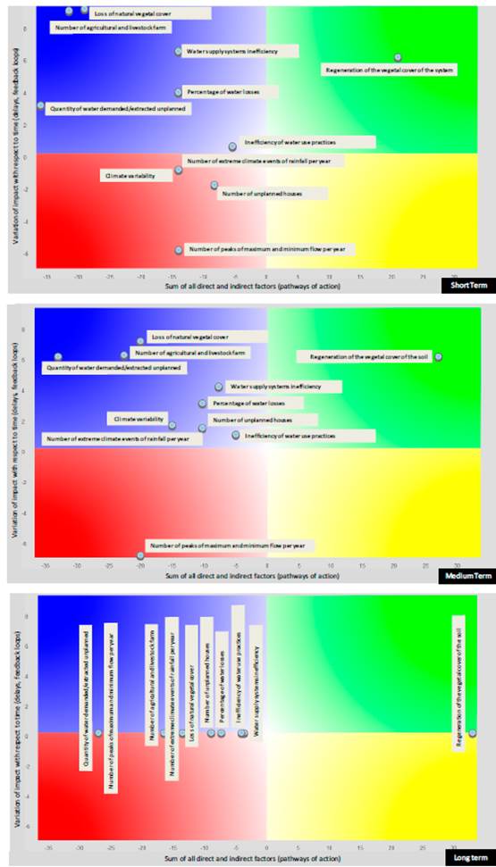
For the short, medium, and long terms, Fig. 3 shows that the regeneration factor of the vegetal cover of the soil was placed in the green quadrant, which positively influences the central factor (quantity regulation). This factor will increase in the future, both in the value of its positive influence and its effect on the amount of water. These results can be attributed to the change in land use from grasslands to vegetation cover caused by the decrease in livestock activity in the area, which has occurred for about five years. This change in land use means a positive impact in the micro-watershed, which, if continued, would contribute to improving the regulation of the quantity of water in the micro-watershed and the adaptation of the socio-ecosystem to the effects of the CV. Through using this method, adaptation measures formulated as a function of Ecosystems-based Adaptation (EbA), like the prioritization of the conservation of forests and sustainable forest management may be proposed to enhance positive effects on water regulation.
Source: The Authors.
Figure 3 Knowledge matrix of the level of regulation of water quantity in the short, medium and long term - High rainfall period.
The FCM revealed that factors such as the inefficiency of the water supply system, the percentage of water losses, the loss of vegetation cover attributed to agricultural and livestock activity in the area, the number of agricultural and livestock farms, the demand and extraction of unplanned water and the inefficiency of the water use practices, all located in the blue quadrant, will diminish in the future, both in the value of its negative influence and the effect on the regulation of the amount of water. These results suggest that over the medium and long term, they will contribute to improving the central factors. Therefore, joining optimization efforts for the Golondrinas water supply system is important, such as the reduction of the percentage of water losses and in the efficient use of water. These measures may be developed by the Administrative Board of the system, who are currently aware of the importance of carrying out studies and actions for improving the supply system once the necessary resources are managed.
Meanwhile, the loss of vegetation cover and the development of agricultural activities show a tendency to improve, and can be achieved over time if actions are taken related to the establishment of agroecological systems with technology for the efficient use of water for irrigation. This approach can work with the implementation of adequate techniques for the tillage of the land that considers the morphology of the micro-watershed. The unplanned demand and extraction of water associated with the increase in the construction of unplanned houses and inefficient irrigation systems can be addressed by implementing actions related to the optimization of the water supply system and the definitions of tenure, land management, and ownership. However, if pressure continues to be placed on the allocation of water for domestic use and the inefficient use of the resources, local water shortages will become worse.
Factors such as the influence of climate variability, the number of extreme climatic events, number of peaks of maximum and minimum flows per year and the increase of unplanned construction of houses, located in the red quadrant, will worsen their effects on water regulation efforts. Among these impacts, the occurrence of El Niño and La Niña events stands out, which cannot be governed. In the medium term, there is a displacement of some factors (climate variability and unplanned housing) towards the blue area, which can be interpreted as the need to implement immediate measures to reduce the negative effect on the water quantity regulation. For this purpose, studying land tenure and rights of use and management, community awareness of the impacts of existing extraction processes, the characterization of water resource uses and the occurrence of extreme weather events is recommended. The displacement can be interpreted using this method in the future since, despite the value of the negative influences increasing, the negative effect may decrease directly or indirectly through the implementation of other measures aimed at improving the regulation of water allocations.
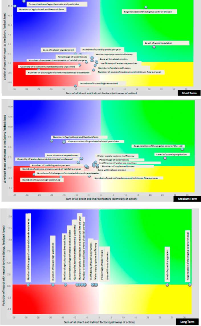
3.2. Regulation of the water quality during high rainfall
The analysis of this central factor (Fig. 4) shows that factors such as the regeneration of the vegetal cover of the soil and the level of regulation of the amount of water, located in the green quadrant, are positively influencing the water quality and can be potentiated. In the future, the positive value of their influences and their effects on water quality will increase. As discussed previously, these results may be associated with the change in land use from livestock to plant cover, in addition to this dynamic, there is a recovery in the level of regulation of water allocations, which has a positive effect on water quality, thereby providing a buffering effect in the variation of the concentrations of chemical pollutants present in the stream water, which presently shows an important variation during the periods of high and low rainfall. For this reason, actions related to forest conservation and sustainable forest management accelerate the regulation of the two studied ecosystem services.
Source: The Authors.
Figure 4 Knowledge matrix of the regulation level of water quality in the short, medium and long term - High rainfall period.
The blue quadrant shows the factors that exert a negative influence on water quality in the short term, but in the medium and long term, these factors will reduce in both the value of their negative influence and their effects on the regulation of water quality. Among these factors are the number of agricultural and livestock farms, concentration of agrochemical and pesticides in the water, number of turbidity peaks per year, loss of natural vegetation cover, number of extreme climatic events of rain per year, areas with natural erosion, inefficiency of the water supply system, and the percentage of water losses. The factors associated with climate variability are known to increase in frequency of occurrence, however, if the implementation of adaptation measures is carried out at the micro-watershed scale, the effects of these phenomena will decrease in the future and thereby improve the resilience of the socio-ecosystem.
The turbidity peaks and the concentrations of agrochemicals and pesticides in the water are associated with agricultural activity and combined with the natural erosion are present in the watershed. To counter these effects, the establishment of agroecological systems with technology facilitating the efficient use of water for irrigation is recommended, which involves the formulation of strategies for the integrated management of pests, the design of cleaner production projects, redesigns of agroecosystems, the use of species more tolerant to water stress, the enhancement of soil organic matter content and the implementation of adequate techniques for tillage of the land. These measures are successful if they have the necessary guidance and advice from the institutions responsible for the management of water and soil resources, through an environmental education strategy that promotes the communal commitment of farmers. The inefficiency of the water supply system and the percentage of water losses are very close to zero, which may indicate lesser influences and effects on the central factor. However, these two factors are key in the regulation of the quantity of water, which affects quality.
The red quadrant shows the factors associated with the number of discharges of untreated domestic wastewater, the number of houses seated in the upper watershed, the inefficiency of water use practices, the number of unplanned houses, the demand and extraction of unplanned water and the maximum and minimum flow peaks per year. These factors have a negative influence on water quality (central factor), and in the future their effects tend to increase. To intervene and thereby reduce domestic wastewater discharges generated indirectly by houses located in the upper watershed, measures can be proposed such as the establishment of individual and collective sanitation alternatives, with community participation and acceptance. These measures may include the identification, management, planning, design, and implementation of feasible sanitation solutions according to the needs of the people. Highlighting the work needed to strengthen community participation is important during all phases of the projects.
The demand and extraction of unplanned water influenced by the peaks of flow in the stream, the increase in the construction of unplanned housing, and the inefficiency in water use practices all directly affect the amount of water, which has an indirect effect on quality. These factors require attention in the short term to avoid a progressive increase in their negative effects, which would exacerbate pollution and increase the concentrations of chemical substances not suitable for human supplies, which would thus put more pressure on purification treatments.
3.3. Regulation of the water quantity during low rainfall
The amount of water in El Chocho stream during periods of low rainfall is similar to its behaviour in high rainfall. The factors are located in the same quadrants and have the same tendency over time. This can be associated with the variations of the weights in factors, such as the demand/extraction of water and the loss of the vegetation cover, not presenting important differences from one period to another.
3.4. Regulation of the water quality during low rainfall
For this climatic period, similar behaviours of the factors located in the green quadrant were obtained. The regeneration of the vegetal cover of the soil and the level of regulation of the water amount positively influenced the central factor, and their tendencies in the short, medium and long terms can be potentiated. These results confirm the need for implementing actions that favour the conservation of forests and the forest management of the soil of the micro-watershed, which may contribute to a natural regeneration of the plant cover and to the regulation of water quality as shown in Fig. 5.
Source: The Authors.
Figure 5 Knowledge matrix of the level of water quality regulation in the short, medium and long term - Low rainfall period.
The factors of the blue quadrant presented differences during periods of high rainfall. Among the factors that exert a negative influence on the central factor and will decrease in both the value of its influence and its effect on the regulation of water quality in the future are: the concentration of agrochemicals and pesticides in water, number of farms with agricultural and livestock activities, losses of natural vegetation cover, the number of turbidity peaks per year, the inefficiency of the water supply system, percentage of water losses, the area of natural erosion, and the number of extreme climatic events of rainfall associated with climate variability. During periods of low rainfall, there was an increase in variables such as the demand and extraction of water, which is related to the permanent shortage in the micro-watershed that affects the water supply and quality of life. Returning to the previously described vulnerability analysis, the low flow rates that occur in the El Chocho stream substantially reduce the supply and availability of water and increase the concentrations of chemical pollutants in the water, which makes water purification difficult and increases the costs of water.
In the red quadrant, the same factors from the high rainfall period were presented. Aspects such as the number of discharges of untreated domestic wastewater and the number of houses seated in the upper watershed were located towards the left end of the horizontal axis, indicating a greater negative influence on the central factor that will grow in the future. To reduce this impact, studying and implementing individual and collective sanitation options that reduce soil and water pollution will be necessary.
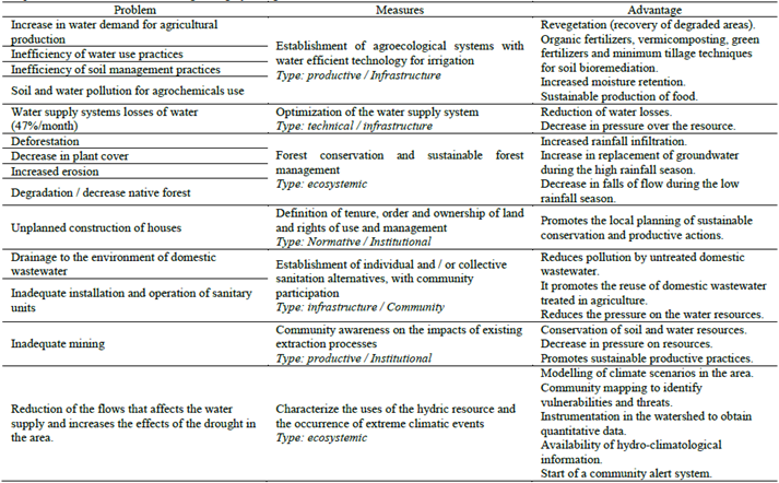
3.5. Adaptation measures as a strategy for regulating hydrological services
The modelling tools facilitate the identification of the interactions between environmental, social, economic, productive, educational, cultural and institutional factors. This makes possible the detection of critical points in the water supply systems, including the users, and establishing intervention routes in favour of conflict resolution for the water use, land use and, in general, the human water supply.
Table 2 Adaptation measures to the CV for regulating hydrological services in El Chocho
Source: The Authors.
This study contributes, in addition to this knowledge through factor identification, a set of anticipatory adaptation measures, which provide socio-ecosystems with tools for adaptive decision making. Several studies and experts have shown how adaptation measures can be successful if they have the support and participation of the communities and with institutional support [2,3,14]. However, the success of their implementation also depends on the management and attainment of economic resources.
Thus, the following measures are proposed based on the results of model implementation and the identification of the main problems related to water supply and water scarcity (Table 2). Additionally, previous studies on the subject and the different existing and useful methods for the design and implementation of EbA actions at national and rural scales were taken into account [10,11,14,15,18].
A comparative analysis of these studies shows that the formulation of adaptation measures requires the identification of problems, actors and solution alternatives, a preparation phase in which the environment, community needs and the results of technical studies and costs are recognized and, finally, an evaluation phase of the measures, where indicators are established to evaluate the efficiency and effectiveness of the measures over time.
Table 2 shows the measures formulated according to the EbA, which were prioritized according to the results of the FCM modelling. For its prioritization, the main criterion were the tendency and degree of influence for each factor on the regulation of water, with priority being given to factors that tended to reduce their impact in the future. Then, measures are proposed for the factors that tended to be maximized and, finally, those factors that tended to worsen. The selection of criteria was based on working with the community, determining their needs and then determining the management techniques and possibilities of obtaining economic resources.
4. Conclusions
The results of the FCM application did not present an important difference between the two climatic periods to which it was applied. In general, the natural regeneration of the vegetal cover of the soil (located in the green quadrant) is a factor that positively influences the regulation of the quantity and quality of the water. In the future its tendency can be become potentialized. Meanwhile, factors such as the loss of vegetation cover, inefficient use of water, increases in the concentration of agrochemicals and pesticides, and turbidity peaks are attributed mainly to agricultural and livestock activity. Moreover, the inefficiency of the water supply system, the percentage of water losses and the increases in the demand and extraction of unplanned water (located in the blue quadrant) are factors that currently exert a negative influence on water regulation, but in the future both the value of their influence and their negative effects on the quantity and quality will decrease. The red quadrant shows the short-term factors that have a negative influence and will have increasing impacts on water regulation efforts. These factors include the number of extreme climatic events associated with climate variability, number of discharges of untreated domestic wastewater, the increase of unplanned construction of houses and the maximum and minimum flow peaks.
Involving the community and institutions is important in the development of projects related to integrated water resources management efforts in rural communities, the development of a motivational stage and encouragement of the development of managerial capacities. Furthermore, this project development process should account for stages that make up the model, with the purpose of reducing the vulnerability of the socio-ecosystem to the impacts of CV and for the protection of hydrological ecosystem services. We conclude that a community approach to considering the factors evaluated in this study will contribute to breaking one of the main barriers found in this study. This barrier was the lack of an organizational culture where the deficiencies of institutional and organizational development are of such magnitude that they limit the implementation of any project at the community level, making it difficult to achieve sustainability in the management of water and sanitation systems, which is a typical situation in rural Colombia.
Globally, adaptation to climate change and climates phenomena have focused on infrastructure and not people. This study contributed to the construction of a participatory diagnosis based on the consultation of the true needs and vulnerabilities of the people, which are often made invisible in the policies of the State. The adaptation measures formulated in this article have the purpose of attaining the necessary quantities of a water supply, these measures were formulated as function of the EbA and, in order of the priority they were related to: the establishment of agroecological systems, optimization of the system of aqueducts, conservation of forests and forest management, definition of the possession and ordering of the land, establishment of sanitation alternatives, community awareness about the extraction processes of resources and extreme weather events. We highlight that for the studied community, initiating an adaptation plan, and taking actions to motivate and strengthen community participation in all phases of the projects to be developed is vital, as they contribute to the sustainability of the projects and the collective benefits that can be brought to the population.

