


 English (pdf)
 Article in xml format
 Article references
 Send this article by e-mail
 Cited by SciELO
  Cited by Google
  Similars in
SciELO
Similars in
SciELO  Similars in Google
 Permalink
1. Introduction
The transformation of natural or rural ecosystems into urban spaces promotes several impacts on plant species which remain in the city due to the loss and degradation of habitats, as well as changes in the structure and dynamics of ecosystems, weakening their ecological resilience. Thus, fragmentation of the native vegetation habitats is incurred, forming small and isolated remnants which are characterized by being little representative of the original forest [1].
The Atlantic Forest is the most fragmented and urbanized biome in Brazil. It consists of various ecosystems such as the Mixed Ombrophilous Forest (MOF), typical of the plateaus of Southern Brazil, with disjunctions in the country’s Southeast Region, Paraguay, and Argentina [2,3]. Due to the predominance of Araucaria angustifolia (Bertol.) Kuntze (araucaria, Paraná pine), mainly in the cold and humid mountain regions of Southern and Southeastern Brazil, MOF is also called Araucaria Forest [4].
The presence of A. angustifolia characterizes the landscape of MOF regions. Furthermore, the species forms ecological associations with both other fauna and flora species, and which are essential to maintain the functional balance of ecosystems [3]. However, the indiscriminate exploitation of the species until the middle of the 20th century, in addition to the pressure for agricultural and urban expansions, led to a constant threat to their populations in Southern Brazil [5].
The deforestation of the Araucaria Forest has caused a reduction estimated to be more than 80% of its original cover, leaving fragments in the landscape which are small, isolated, intensely impacted, and with few characteristics of the original vegetation [5,6]. As a result, A. angustifolia is currently considered “Endangered” (EN) by the National List of Endangered Flora Species, published in the Brazilian Ministry of the Environment Ordinance no. 443 from December 17th, 2014 [7]. The threat category is no longer severe due to the species being present in protected areas and having high cultivation potential [5].
Nevertheless, although most of Curitiba is located in the area covered by MOF, the suitability for the forest fragments in the city to the autoecology of A. angustifolia is not known, especially those protected by green areas. Therefore, the hypothesis tested herein was that the urban forest fragments in Curitiba generally have relevant environmental conditions to the occurrence and conservation of the species.
Thus, the objective of this study was to verify the relevance of the urban forest of Curitiba, Paraná, Brazil, for the conservation of A. angustifolia, considering the potential distribution of the species and the spatialization of the protected areas of the municipality.
2. Material and methods
2.1 Study area
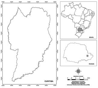
The study covered the municipality of Curitiba, located in the First Plateau of Paraná, in the Southern Region of Brazil (Fig. 1), whose ground zero is located at the coordinates 25°25'46,89754" S and 49°16'16,56011" W [8]. The total area of Curitiba is 432.17 km², at 934.6 m of altitude [9].
The climate zone of Curitiba is Cfb according to the Köppen-Geiger classification, with characteristics of a humid subtropical climate [9]. The average annual temperature is 17.51 °C, reaching 33.87 °C in the summer and -2.35 °C during winter; the average rainfall is 1587.52 mm/year and the average annual relative humidity is 81.94% [10].
There are forest ecosystems (Montane and Alluvial MOF) and natural grassland in Curitiba, where the eastern limit of the geographic distribution of A. angustifolia was located. It originally dominated the forest canopy and characterized the region’s landscape [3,11]. In addition to A. angustifolia, Ocotea porosa (Nees & Mart.) Barroso (imbuia) and Ocotea odorifera (Vell) Rohwer (sassafras) tree species predominated and helped characterize the landscape of the MOF regions together with other species from the Fabaceae and Myrtaceae botanical families [3,11].
Grasslands occurred in the south-central portion of the municipality with a predominance of species from the Poaceae family, interspersed by small forest nuclei mainly consisting of A. angustifolia, O. porosa and O. odorifera [2].
The urban forest of Curitiba covers 43.69% of its total area, being 34.70% private and 8.98% public, of which only 3% are within green areas [12]. The urban forest of Curitiba is currently composed of 1.183 green areas, including parks, woods, landscaped boulevards, gardens, and Private Reserves of the Municipal Natural Heritage (RPPNMs), among others [13].
2.2 Methodological procedures
The MaxEnt® (Maximum Entropy) algorithm [14], version 3.4.1 of 2017, was used to elaborate the potential distribution model of A. angustifolia in Curitiba. This algorithm is defined as a machine-learning technique which estimates the probability distribution of species occurrence in the landscape through an exponential function [15]. The potential distribution modeling enables evaluating the representativeness of the most suitable sites for the conservation of the species within protected areas [16].
A logistic function was used to elaborate the model, which provides an estimate ranging from 0 to 1% probability of the species’ presence [14]. This occurrence probability indicated the environmental adequacy for the species’ occurrence [17]. A total of 1,000 combinations were established with 10 repetitions in the cross-validated method, and the radius was adjusted to “-30” due to the work scale [18].
Verification of the environmental criteria most relevant to the model when used alone and the accuracy estimation were performed through the Jackknife test and the Area Under the Curve (AUC), respectively [18]. Thus, 10 models were generated and the one with the highest AUC values (closer to 1) was chosen [18].
Next, a total of 26 georeferenced points of A. angustifolia collected from GeoEye-1 satellite images with a spatial resolution of 0.5 m from 2016 were used to compose the model. These images were available in the Google Earth® Pro software, which were later confirmed in the 2019 image. The unique shape of the A. angustifolia top facilitated locating and georeferencing individuals.
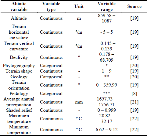
Thirteen environmental criteria considered relevant for the species distribution were also used, with a spatial resolution of 30 m [18] (Table 1). All abiotic criteria were previously correlated by Pearson’s Correlation to avoid spatial autocorrelation [18].
Table 1 Abiotic criteria used for elaborating the potential distribution modeling of A. angustifolia.
Source: The authors.
Note: *: Montane Mixed Ombrophilous Forests, Alluvial Mixed Ombrophilous Forests, and grassland; **: Yellow Cambissol, Red-yellow Latossol, Red-yellow Argissol, Aluminic Argisol e Hydromorphic Soil; ***: Modern Sediments, Gneiss Migmatitic Complex and Guabirotuba Formation. Source: Reis et al. (2019a). [18]
The original map generated by the MaxEnt® algorithm contained 14 classes of occurrence probability of A. angustifolia, and the delimitation of protected areas was then reclassified into three environmental adequacy classes for the species: high, medium, and low. This reclassification was performed based on the intervals of the original classes, each approximately 33% of the occurrence probability of the species [17].
This step helps to quantify potential areas for the presence of the species, thus enabling to define the best areas for its conservation [17]. To do so, a supervised classification was used in the ArcGis® 10.3 software.
The model map was superimposed to the protected forest fragments represented by the delimitation of 85 public and private green areas with the most preserved natural characteristics of the study area. Therefore, the term Selected Green Areas (SGA) was chosen, aiming toward not including predominantly anthropic areas such as introduced vegetation and impermeabilized soil. Thus, all green areas which met the requirement to be less anthropized were considered.
The analyzed green areas were defined from vector files provided by the Institute of Research and Urban Planning of Curitiba (IPPUC) from November 2019, totaling 85 green areas. They were: 28 parks, 25 Private Reserves of the Municipal Natural Heritage (RPPNMs), 18 woods, 10 Urban Biodiversity Conservation Woods (BCBUs), 1 Ecological Station (ES), 1 Wildlife Reserve (RVS), 1 botanical garden, and 1 zoo.
The area occupied by the occurrence probability classes within each protected area was subsequently calculated [17]. Such quantification is important in order to better detail the terrain surface of each SGA, as differences can occur mainly related to changes in soil properties depending on the water regime and its fertility [17,23]. Spatial analyses were performed in ArcGis® 10.3.
3. Results
Training data values ranged from 0.926 to 0.961 and Test data values ranged from 0.362 to 0.968. The chosen model had AUC values for both training data and test data simultaneously closer to 1, with 0.934 and 0.945 respectively.
The pedology variable contributed with 45.4% of the response provided by the model (Table 2), followed by declivity (23.2%) and maximum temperature (12.5%). The least relevant variable was the minimum temperature, with 0.1% of the total response indicated by the model.
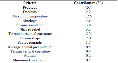
The pedology, maximum temperature, and declivity variables were the most representative of the potential distribution of the A. angustifolia in Curitiba when they were used alone, as indicated by the Jackknife test.
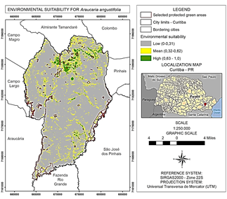
The potential distribution map indicated the northern region of Curitiba with the highest environmental adequacy for the species (Fig. 2), presenting the three largest and most suitable continuous polygons for the occurrence of A. angustifolia. Although well distributed, the occurrence probabilities in the rest of the municipality are higher along the watercourses.
Source: The authors.
Figure 2 Environmental adequacy for A. angustifolia in the municipality of Curitiba, Paraná.
A total of 62 (72.94%) of the 85 green areas evaluated have a medium and or high degree of adequacy for A. angustifolia, represented by 25 parks, 14 RPPNMs, 14 woods, 5 BCBUs, 1 ES, 1 RVS, the botanical garden, and the zoo. Thus, 59 of these areas presented medium adequacy (69.41%) and 36 showed high adequacy (42.35%) (Fig. 2).
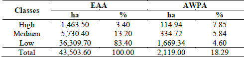
Most of the area in Curitiba does not present conditions which are favorable to the occurrence of A. angustifolia. However, all of the municipality presents areas of medium or high environmental adequacy regarding spatial distribution, mainly in the northern region, coinciding with the Montane and Alluvial MOF regions. A total of 7,193.9 ha (16.6%) of Curitiba corresponds to high and medium environmentally adequate regions for the occurrence of the species. Of this area, 449.66 ha are within the green areas selected for this study, which corresponds to 13.69% of the relative area present within SGA (Table 3).
Table 3 Classes of environmental adequacy for A. angustifolia in the municipality of Curitiba, Paraná.
Source: The authors.
Note: EAA: Environmental adequacy area; AWPA: Area within protected areas.
The green areas with the highest amount of medium and high classes of environmental adequacy are Iguaçu Park, with 93.5 ha (17.6% of its total area); Bugio RVS, with 80 ha (10.9%); and Barigui Park, with 64.5 ha (48%).
Proportionally to the size of each green area, five have 100% of their surface suitable for the occurrence of A. angustifolia: Alemão, Gutierrez, Zaninelli Woods, and Bosque da Coruja, and Bacacheri RPPNMs, which together have 14.5 ha. Other SGA present more than 90% of their areas as being favorable to the occurrence of the species: 300 Anos, Fazendinha, Pilarzinho, Irmã Clementina, and João Paulo II Woods, Vista Alegre and São Lourenço Parks, and Barigui, and Mirante do Parque Barigui RPPNMs.
4. Discussion
This study aimed to verify the relevance of the urban forest of Curitiba for the conservation of A. angustifolia from a comparison between the potential distribution model of the species with green areas previously selected from the municipality.
Although this is a common species in the Curitiba region, the potential distribution modeling for A. angustifolia indicated that its occurrence is conditioned by specific landscape factors such as topography and pedology. The presence of species individuals in a given location may not necessarily characterize it as the best environment for its development, since individuals may have adapted to less favorable conditions, even if they do not meet all the autecological demands of the species and therefore do not develop as well as possible [18].
Hence, the results found herein were able to detail the most suitable environments for A. angustifolia in Curitiba, indicating that even though the environmental adequacy for the species is distributed throughout the whole municipality, which was already expected, the northern region presents the best environmental conditions to meet its autecological demands.
The AUC values indicated that the model generated from the selected environmental variables explains 93.4% of the species’ distribution in the study area. This value is considered satisfactory since it is close to 100% [15].
As observed in Fig. 2, the northern region of Curitiba favors the occurrence of A. angustifolia. This is explained by pedology and declivity, as these variables were the most significant among the criteria used in the potential distribution model of the species.
Variables related to pedology, especially soil depth, are among the main factors responsible for establishing the species [24], since the soils need to be at least 1 m deep. Even under appropriate climatic conditions, the occurrence probability of a given species decreases if the soils do not present adequate characteristics for their establishment [25].
The result found for A. angustifolia in Curitiba regarding declivity is consistent with another study which verified non-homogeneous distribution of individuals of the species in Irati, Paraná, Brazil, and predominantly found the individuals in higher declivity [26].
On the other hand, the occurrence of A. angustifolia is also related to flatter reliefs located in the south-central portion of Curitiba, as confirmed by most of the linear polygons of the medium class presented in the environmental adequacy map. The species occurrence was significant in valleys near watercourses in Curitiba before its urbanization [2,3]. Plains are formed in these localities where the soil results from alluvial sediments, where the drainage is favorable and the groundwater is superficial and or commonly emerges, thereby originating Alluvial Mixed Ombrophilous Forest [6].
Areas with soil structure and texture favoring drainage, soil aeration, and water retention, along with greater depth for root development, are considered a priority for the conservation of A. angustifolia [27]. These regions generally have more accentuated slopes where water accumulation is frequent.
The results show that the species can establish itself in different declivity situations, provided that there is a certain depth to the soil. Moreover, in the case of anthropized environments, the heterogeneity of the urban landscape should be considered as the most important factor to predict the most appropriate areas for the occurrence of species in cities due to the influence that the landscape exerts on its autecology [28].
Although the species is indigenous to Curitiba, most of the municipality has environmental conditions which are not the most favorable to the occurrence of A. angustifolia. Furthermore, most of the existing protected areas currently have medium to high adequacy for establishing the species individuals, especially parks and woods. These green areas are mainly located in the northern region of the municipality and close to waterways. The green areas of Curitiba which have the best environmental conditions for the occurrence of O. odorifera are those located in the northern portion of the city [17]. Thus, these forest fragments are apt for preserving the predominant and indigenous endangered MOF species in Curitiba.
Although forest fragments with extensive areas more significantly contribute to the conservation and propagation of threatened species, the role of smaller forest fragments becomes increasingly important due to the constant exploitation of A. angustifolia [29]. Therefore, the result shows the importance of creating new urban protected green areas, including in private areas, in the region with greater environmental adequacy for A. angustifolia in Curitiba.
Most of the Private Reserves of Municipal Natural Heritage (RPPNMs) are already located in the north of the municipality [30], demonstrating to be an effective measure for preserving A. angustifolia and other indigenous MOF species which compose the urban forest of Curitiba.
According to Reis et al. (2019b), the SGA with the greatest contributions to the environmental adequacy of A. angustifolia may provide better conditions to protect current species individuals, and also to promote natural regeneration and reintroduce planting. Moreover, the implementation of Urban Biodiversity Conservation Woods (BCBUs) by the Curitiba government is an important tool to preserve the characteristic species of the MOF in the region. Reis et al. (2019b) corroborate this statement, recommending to implement BCBUs aimed at preserving native MOF species, especially those ecologically associated with A. angustifolia.
Hopefully, the results found herein may provide subsidies for preserving the species in the urban environment, thus guiding public mangers to actions which favor good development of its individuals, especially considering that the potential distribution of native species in urban environments contributes to promoting biotic interactions between them, and thus favor the functionality of ecosystems [28].
5. Conclusion
It can be concluded that the potential distribution model employed was satisfactory and effective in assigning the best areas for cultivating and preserving A. angustifolia, presenting an accuracy of 93.4%.
Establishing A. angustifolia is mainly favored in the northern region of Curitiba, although possible occurrence of the species is well distributed throughout the entire territory of the municipality, especially in valleys along the watercourses, or in areas where drainage, aeration, depth and water retention in the soil are greater, constituting characteristics of Alluvial Mixed Ombrophilous Forests.
A total of 7,193.9 ha (16.6%) of Curitiba has medium and or high environmental adequacy for the species, and 449.66 ha of it (13.69%) is located within the selected green areas for the conservation of A. angustifolia.
We primarily recommend planting and preserving A. angustifolia in the potential distribution area indicated by the model through creating RPPNMs or BCBUs in locations with a higher degree of slope or near watercourses.
We expect that the municipal public sector will take the necessary measures to contribute to the species conservation given its economic and ecological importance, and look for alternatives to reduce its threatened extinction status. To do so, knowing how environmental characteristics influence the adaptability of native species in more detail is essential, especially in urban environments where the presence of these species significantly contributes to mitigate the impacts of climate change currently potentiated in urban centers.

