


Servicios Personalizados
Revista
Articulo
 Inglés (pdf)
 Articulo en XML
 Referencias del artículo
 Enviar articulo por email
Indicadores
-
 Citado por SciELO
 -
 Accesos
Links relacionados
-
 Citado por Google
 -
 Similares en
SciELO
Similares en
SciELO -
 Similares en Google
Compartir

 Permalink
Boletín de Geología
versión impresa ISSN 0120-0283versión On-line ISSN 2145-8553
bol.geol. v.30 n.1 Bucaramanga ene./jun. 2008
RELATIONSHIP BETWEEN FLUVIAL CLASTIC
SEDIMENT AND SOURCE ROCK ABUNDANCE IN RAPTI
RIVER BASIN OF CENTRAL NEPAL HIMALAYAS
Naresh Kazi Tamrakar1; Madhusudan Bhakta Shrestha2.
1 Central Department of Geology, Tribhuvan University, Kirtipur Kathmandu Nepal(ntamrakar@hotmail.com)
2 Department of Forest Science, Shinshu University, Japan
ABSTRACT
Many tributaries from carbonate sedimentary, metamorphic and igneous rocks of the Lesser Himalayan and clastic sedimentary rocks of the Sub-Himalayan Ranges carry gravelly sediments to the Rapti River. River bar sediments were analyzed for composition and texture to evaluate downstream changes in properties, and to establish relationship between proportion of clasts and the abundance of rock types in the source areas. Percent quartzite clast or granite clast increases whereas that of carbonate, schist or slate decreases along downstream. The largest grain size decreases downstream, whereas flatness index and sphericity tend to increase. Despite of little diminish in relative abundance of rock types in source areas along the river, the relative proportion of corresponding clast type shows rapid reduction (e.g. slate or phyllite or carbonate clasts) or rapid enhancement (e.g. granite clast). The relationships of quartzite clast and schist clasts with their corresponding source rocks are statistically significant suggesting that these clasts can provide clue to source rock abundance. About 85 to 94% of the gravel clasts represent rock types of the Lesser Himalayan Range suggesting that this range has been contributing enormous amount of sediments.
Keywords: River sediment, gravel composition, Lesser Himalaya, Sub-Himalaya, Siwalik Range
RELACION ENTRE LOS SEDIMENTOS CLASTICOS FLUVIALES Y LA ABUNDANCIA DE LA ROCA FUENTE EN LA CUENCA DEL RIO RAPTI EN LOS HIMALAYAS DE LA PARTE CENTRAL DE NEPAL
RESUMEN
Numerosos ríos tributarios aportan sedimentos al río Rapti, a partir de rocas sedimentarias carbonatadas, metamórficas e ígneas en los Lesser Himalaya, y de rocas sedimentarias clásticas de la cordillera Sub-Himalaya. Se estudio la composición y textura de los sedimentos de barreras fluviales para evaluar los cambios durante el transporte y establecer la relación entre la proporción de clastos y la abundancia de las rocas en las áreas fuente. El porcentaje de clastos de cuarcita o granito se incrementa, mientras que los clastos de carbonatos, esquistos o pizarras decrece con respecto a la distancia de transporte. El tamaño de los clastos decrece corriente abajo, mientras que el índice de aplastamiento y esfericidad tiende a incrementarse. No obstante, la poca disminución en la abundancia relativa de las rocas en las áreas fuente a lo largo del río, la relativa proporción de los correspondientes clastos muestran una rápida reducción (clastos de pizarras o filitas o rocas carbonatadas) o un rápido incremento (clastos de granito). La relación de los clastos de cuarcita o esquistos con su correspondiente roca fuente son estadísticamente significativos, sugiriendo, que estos clastos pueden proveer la clave de la abundancia de estas rocas. Entre el 85 y 94% de los clastos de gravas representan tipos de roca de la cordillera Lesser Himalaya, sugiriendo que esta cordillera ha aportado enormes cantidades de sedimentos.
Palabras Claves: sedimento fluvial, composición grava, Lesser Himalaya, Sub-Himalaya, Siwalik Range
INTRODUCTION
Drainage basins of the Himalayas are known for high rates of erosion and frequent destructive slope movements (Upreti and Dhital, 1996; Bhusal, 1998; Tamrakar et al., 1999; Shrestha et al., 2005). Many landslides and debris flow had occurred in rivers of Central Nepal Lesser and Sub-Himalayas (NEA, 1989; Dangol et al., 1996). Shrestha et al. (2005) pointed out that rivers of the Lesser Himalaya have high stream power and are capable of moving huge amount of sediments. Sediments thus derived are moved through the river system, partly stored in rivers, and partly reworked during season of high flows. Recently, concerns are growing in relative contribution of sediments from various parts of the basin.
Degree to which river sediment, especially gravel, reflects source area has been addressed by few authors (Pettijohn, 1957; Pittman & Ovenshine, 1968; Cavazza et al., 1993). Some of these studies showed that gravel abundance had reflected proximity to source rather than relative abundance of rock types in outcrop (Pettijohn, 1957; Pittman & Ovenshine, 1968). Different workers also documented modification of size (Jones, 2000), roundness (Pittman & Ovenshine, 1968; McPherson, 1971; Mills, 1978) and form (Sneed & Folk, 1958) of gravel along the river course. Study of river sediments may be one of the several attempts in recognizing source areas. This paper attempts to reveal downstream changes of composition and texture of gravel clasts from the basin of known climate, physiography and geology, and to establish relationship between abundance of clast type in river and abundance of rock types in the source area (of mixed sedimentary, metamorphic and igneous rocks). Recognizing a link between source area and river sediment may be helpful for provenance study of ancient conglomerates, whereas distribution of proportion of sediments in river probably indicates potential contributing source areas in river basin.
GEOMORPHOLOGY AND CLIMATE OF BASIN
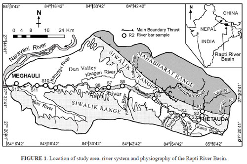
The study area is located in the Central Nepal, where the Rapti River Basin (RRB) covers 3374 km2, including portions of the Lesser Himalaya (Mahabharat Range) in the north, the Sub-Himalaya (Siwalik Range) in both north and south, and the Dun Valley in the center (FIGURE 1). The Mahabharat Range has the highest elevation (2347 m a.s.l.). The Siwalik Range with 1000 m high hills makes distinct contrast with the Mahabharat Range. In the southernmost region, the Siwalik Range is about 800 m high. The Dun Valley is oriented E–W in the central portion of RRB and has a regional gentle westward slope.
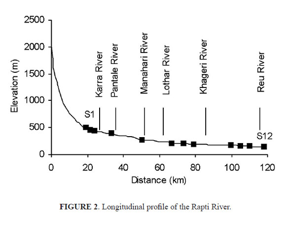
The Rapti River stretches for 118 km from the headwaters to the outlet with an average slope of 3.56 % (in the Mahabharat and the Siwalik Ranges) and 0.02 % between the emergence in the Siwalik Range and the outlet point (FIGURE 2). After emerging from the Siwalik Range, the Rapti River takes meandering course, and at the middle stretch it becomes braided with several middle bars. Many tributaries contribute the river from the northern and southern regions (FIGURE 1).
RRB experiences a humid subtropical climate, with a wet period between June and September and a dry period between November and April. Annual rainfall is 1500–2000 mm in the headwaters (DHM, 1998). Maximum and minimum monthly rainfalls occur in July and December, respectively. In the Dun valley (Hetauda Meterological station), the mean annual rainfall between 1987 and 2004 varies from 1847 to 3323 mm. More than 80 % of this rainfall is observed during the wet period. The average annual air temperature is 23.1o C, and the average relative humidity is 78% in the morning.
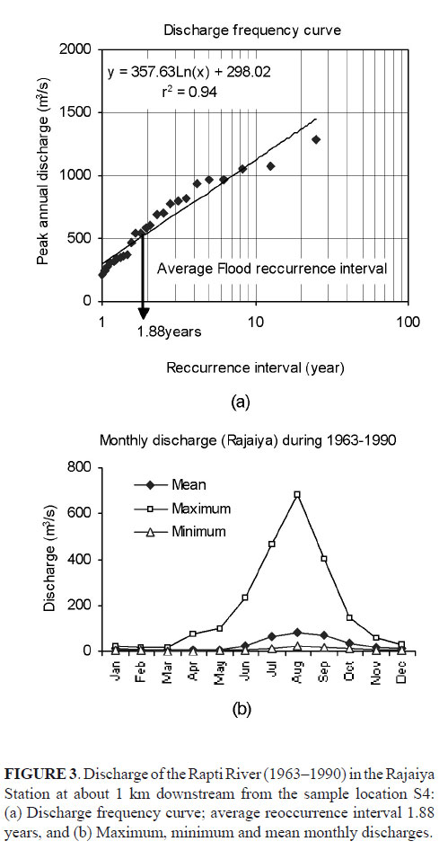
Annual peak discharge of the Rapti River averages 525 m3s–1 with reoccurrence interval of 1.88 years (FIGURE 3a) in the Rajaiya Station (DHM, 1998) at about 1 km downstream from the sample location S4 (FIGURE 1). The maximum monthly discharge ranges from 18.5 to 684 m3s–1. June to September is the period of high flows (FIGURE 3b).
GEOLOGICAL OUTLINE
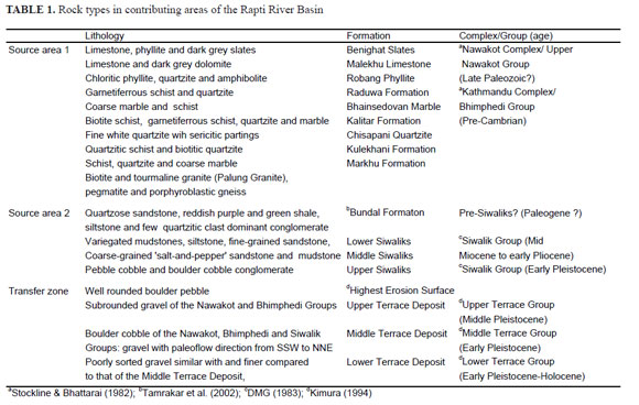
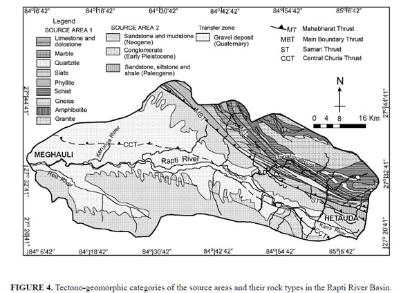
Four major thrusts extending NW–SE and dipping NE demarcate the tectono-geomorphic zones in RRB (FIGURE 4). The Mahabharat Thrust (MT) separates the overlying high-grade metamorphic rocks from the underlying low-grade metasedimentary rocks of the Lesser Himalaya (Stöcklin & Bhattarai, 1982). The former comprises schist, quartzite, marble, gneiss and the intrusions of tourmaline granite, and the latter comprises slates, phyllite, chloritic phyllite, limestone, dolostone and quartzite. The Main Boundary Thrust (MBT) separates the Lesser Himalayan rocks from the underlying Sub-Himalayan rocks. The Samari Thrust separates a narrow thrust sheet of sedimentary rocks (Pre-Siwaliks?) comprising mainly quartzose sandstone, shale siltstone and few conglomerate from the underlying Siwalik rocks (Tamrakar et al., 2002). The Siwalik Group constitutes fine- to coarse-grained sandstone, siltstone, mudstone and conglomerate (Tamrakar et al., 2003). The Central Churia Thrust separates the Siwalik belt in to northern and southern belts. Between these belts is located the Dun Valley, which is composed of Mid Pleistocene to Holocene terrace deposits composed of gravel, sand and mud (Kimura, 1994). The sediments of these terrace deposits were mostly derived from the Lesser Himalayan Ranges from the north during Mid Pleistocene, and were then reworked by the north flowing streams originated from the Siwalik Range of southern region of RRB between Late Pleistocene and Holocene (Kimura, 1994).
METHODOLOGY
Based on rock types and geomorphic regions, two major source areas (SA1 and SA2) and a transfer zone (SA3) were distinguished (TABLE 1 and FIGURE 4). Percentage of rock types available in the source area lying upstream of the selected sampling locations was determined using image analyzer in GIS and topo-sheets of 1:25,000.
welve samples were obtained from river bars of the Rapti River between Hetauda and Meghauli (FIGURE 1). About 200 clasts (>2 mm) were counted from the area of 4 m2 for modal analysis. The b-axes (intermediate axis) of ten largest clasts within 10 m around the sampling area were measured to obtain average maximum clast size (Dmax) in each locality. About 100 clasts from each sampling area were picked up randomly for shape analysis in the laboratory. Further, matrix (<2 mm) of 500 grams was obtained from the same sampling area in each locality. Each sampling area was photographed and 200 clasts were grid counted for b-axis using NIH Scion Image Analyzer. The matrix samples were sieved at 1Φ interval. The volume by weight percentage of matrix size grades was combined with the grid by number size grade of clast to obtain the overall grain size distribution for each sample. Then the graphic measures were calculated after Folk & Ward (1957).
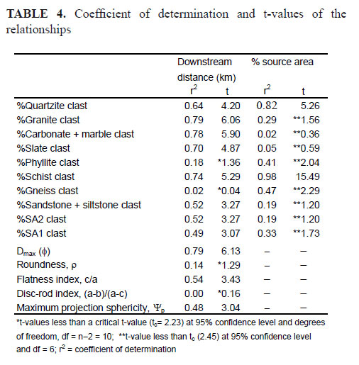
Each of the 100 clasts sampled was measured for the longest (a), intermediate (b) and the shortest (c) axes, and estimated for roundness (ρ) using a Powers’ (1953) chart. These axes were used to obtain axial ratios c/a and (a-b)/(a-c) and maximum projection sphericity Ψp ((c2/ab)0.33) after Sneed & Folk (1958). Finally, a bivariate statistical approach was used to establish various relationships. Significance of the relationships was tested comparing the observed t-value with the critical t-value at 95% confidence level and n–2 degrees of freedom, where n stands for the number of samples.
RESULTS
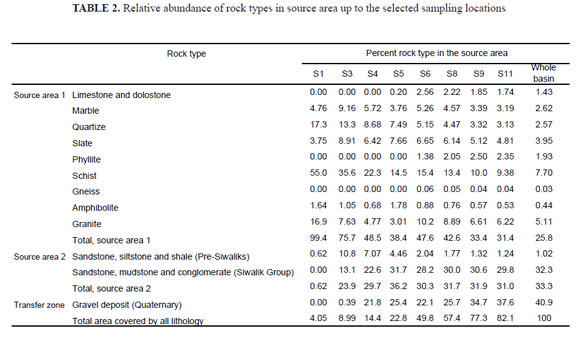
Source area rock types
The relative percent of source area for each rock type is indicated in TABLE 2. SA1 is the Lesser Himalayan source area, located north of the MBT. SA2 lies south of the MBT in the Sub-Himalaya, and includes mainly the rocks of the Siwalik Group, and subordinately the Pre-Siwalik rocks. The Dun Valley, which broadly consists of gravel deposits, which themselves were derived originally from SA1 and SA2, is considered a transfer zone (SA3). Usually the relative percent of SA1 exceeds that of the SA2 in each sample location. The percent SA1 decreases whereas the percent SA2 increases from the upstream to the downstream stretches of the river. SA3 (transfer zone) abundance increases downstream. Among the rock outcrops, percent quartzite diminishes while percent schist increases from upstream to downstream. Therefore, the relative percent of contributing areas in the basin is not constant along the river course. The relative percent of rock type of SA1 becomes reduced remarkably as the Rapti River enters the wide Dun Valley.
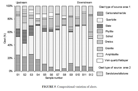
Clast composition
Quartzite is a common clastic constituent in the modal composition and range from 21 to 66% (FIGURE 5). Granite (2–25%), carbonate plus marble (2–26%) and sandstone plus siltstone (6–17%) are the subordinate constituents. Slate and schist clasts appear to be substantial in the samples from the upstream stretches (S1, S2 and S3), while granite and quartzite clasts represent the downstream stretches better compared to other clasts. From the clastic constituents it is observed that the clast from source area 1 (SA1 clast) dominates the clast from source area 2 (SA2 clast) in each of the samples.
Grain size measures
Gravel forms major proportion of the sediment (TABLE 3) except for two samples (S3 and S13), which have high sand. The median grain size (Φ50) varies from -3.80Φ(13.93 mm) to -5.90Φ(59.71 mm), and belongs to pebble size-grade. The largest clasts (Dmax) range from -6.59Φ (96 mm) to -9.65Φ (802 mm). Dmax of the first five sample locations are fine to medium boulders, and of downstream locations are fine to coarse cobbles. The sediments are poorly to very poorly sorted, and are fine to very fine skewed showing dominance of gravel over muddy sand matrix (TABLE 3).
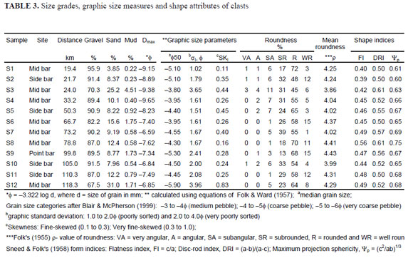
Grain shape
Clasts are subrounded (ρ= 3.86) to rounded (ρ= 4.43) (TABLE 3). Although roundness distributions are similar among the samples, there exists notable fluctuation in proportion of two dominant categories (subrounded and rounded) in the downstream stretches (TABLE 3). The shape of clasts exhibits mostly the bladed forms. The maximum projection sphericity, Ψp which is well correlated to settling velocity of grains (Sneed & Folk, 1958) varies between 0.60 and 0.75 exhibiting relatively low to medium sphericity of the clasts.
CLAST COMPOSITION AND TEXTURE VERSUS DOWNSTREAM DISTANCE
Proportion of quartzite clast or granite clast or sandstone plus siltstone clast tend to increase against downstream transport, while %carbonate plus marble, %slate and %schist clasts tend to decrease logarithmically (FIGURE 6; TABLE 4). The trend of %quartzite clast seems to be obscured at S5, S9 and S12, perhaps due to dilution by mixing of other clasts from major streams contributing from the northern part of the RRB.
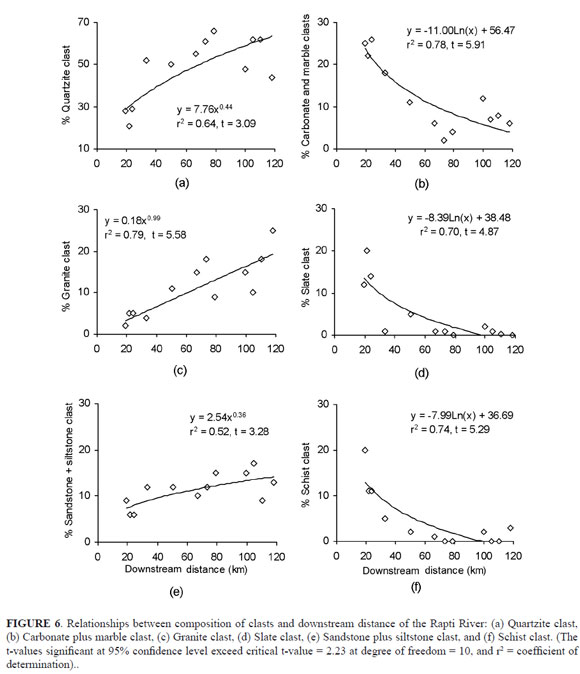
Considering size parameters, only Dmax correlated significantly (FIGURE 7a; TABLE 4) with downstream distance. Dmax tends to diminish logarithmically with river transport. Jones (2000) suggested that abrasion loss and/or hydraulic sorting are the reasons for size reduction of gravel they studied. In present study, the downstream decrease of size of the largest clast is probably attributed to decrease in stream competency because of reduction in slope in the middle and downstream stretches.
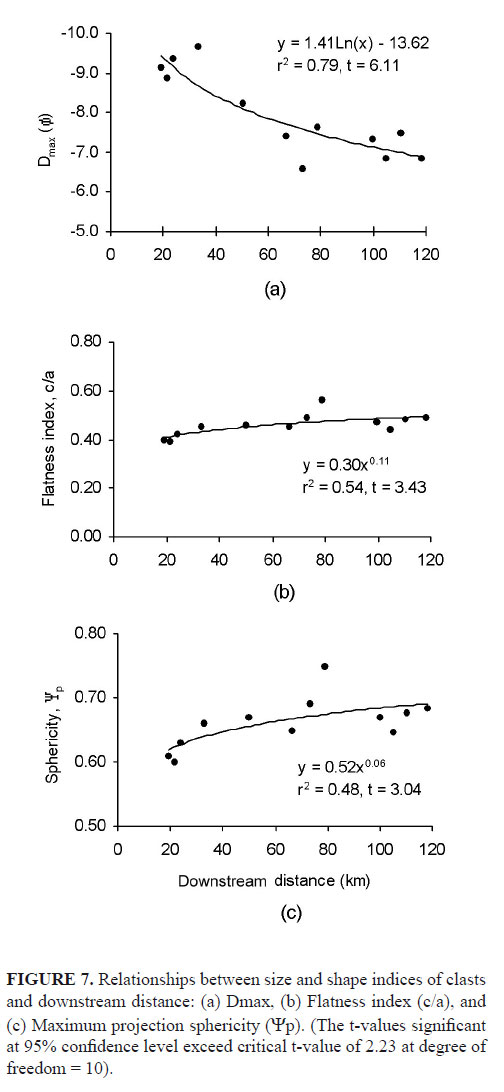
Among the shape parameters, roundness does not vary significantly along the distance downstream probably due to reduced stream competence. Mill (1978) also found no significant trends for 10 out of 30 case studies. McPherson (1971) however, obtained negative correlation between stream slope and pebble roundness. The disc-rod index does not correlate well, but flatness index (c/a) and maximum projection sphericity (Ψp) however yield significant positive correlations with the downstream distance (FIGURE 7b & c; TABLE 4), although in some sampling locations at downstream stretches, these attributes are much higher than the general trend. The high values of shape attributes are possibly caused by increased proportion of quartzite and granite clasts, which have generally compact or spheroid block forming capability (Sneed & Folk, 1958). Presumably, some recycled clasts from the transfer zone might have been contributed in the middle to the lower stretches of the river, thus enhancing the shape attributes.
CLAST TYPE A FUNCTION OF SOURCE AREA ABUNDANCE
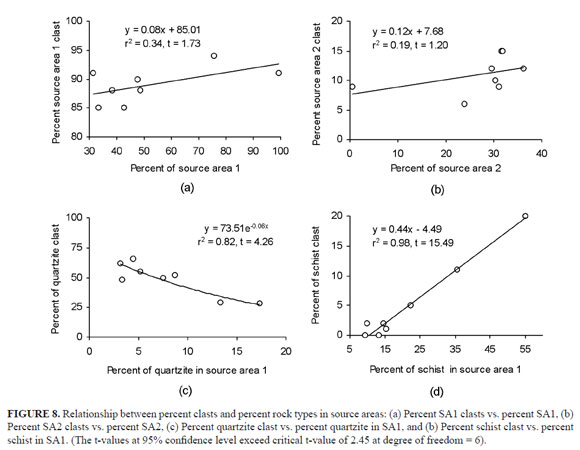
Percent SA1 clast and percent SA2 clast were correlated with the relative percent of the corresponding source areas lying upstream of the selected sample locations (TABLE 4). The relations were slightly positive but were not strong or significant statistically (FIGURE 8a & b). It means that changes in each source area do not influence percent clast type contributed from the corresponding source area. If we remind the decreasing and increasing trends of SA1 and SA2 (TABLE 2), respectively, we see that percent SA1 clast remains roughly constant, despite of rapid decrease of the percent SA1. Also percent SA2 clast remains constant, despite of the rapid increase of SA2 in RRB. The percent SA1 clast has been maintained in the sediment, while the percent SA2 clast has been diluted and therefore underrepresented.
Persistence of SA1 clast in the river sediments along the river course may be attributed to frequent mixing process from the major tributaries, and relatively higher durability of SA1 clast compared to SA2 clast. Underrepresentation of SA2 clast along the river course is perhaps because of low durability or low preservation potential of sedimentary clastic rocks (Cavazza et al., 1993). Other possible reason could be due to morphometric characteristics of the subwatersheds of SA2. Subwatersheds in SA2 (Siwalik Range) have larger drainage areas and lower stream gradient compared to the subwatersheds of the Mahabharat Range. Due to this morphometry most of the sediments from SA1 come to deposit within the subwatersheds of the Siwalik Range as fluvial entrainment could be expected low to flush out sediments during normal seasons (Shrestha et al., 2005), and therefore dilute the proportion of SA2 clasts. However, some major contributing streams (FIGURE 1) could have supplied SA2 clast only during high and catastrophic flows. Therefore, the sediment production in SA1 and transfer from SA1 may be larger compared to that from the SA2. Furthermore, some of the clast types of SA1 (quartzite and granite) could have survived destruction during transfer because of their relatively high durability. Proportion of these clasts therefore increase in downstream localities. Whereas, schist or slate clasts could have been destroyed upon transport because these clasts are mechanically unstable in high gradient stream (Cameron & Blatt, 1971).
To further explore the variation of clast types of SA1 against their corresponding rock type abundance in SA1, each of the clast types were correlated with the corresponding rock types in SA1 (TABLE 4). Only two relationships, percent quartzite clast and percent schist clast, yield significant negative and positive correlation, respectively (FIGURE 8c & d). The percent quartzite clast tends to increase downstream against downstream decrease of its source rock in SA1. In contrast, the percent schist clast tends to decrease downstream as the percent schist rock in SA1 diminishes downstream. Both relationships show strong link between rock type abundance in the sources and clastic abundance in the river sediment. In the rest of the relationships, the percent clast either increases rapidly (granite clast) or decreases rapidly (carbonate plus marble clast or slate clast) against downstream reduction of their corresponding source rocks. We suspect rapid weathering of carbonate plus marble clasts and slate clast (mechanically unstable due to presence of cleavage) due course of transport.
CONCLUSIONS
1.The Rapti River sediments are composed of clasts of low- 1. to high-grade metamorphic, igneous and sedimentary rocks reflecting contribution from the mixed source rocks. Among the clasts, %granite and %quartzite clasts increase while %carbonate plus marble, %slate and %schist clasts decrease downstream with statistically significant correlation. Despite of the same opportunity of being derived SA1 clasts from the same source area (SA1), proportions of SA1 clasts tend to vary along downstream distance probably because of differing durability. Much of sediments (85 to 94%) of the Rapti River represent rock types of the Lesser Himalaya (Mahabharat Range) suggesting that it has been contributing enormous sediments. Many rivers, which originate from the Lesser Himalaya with unstable slopes and mass movements, have probably more capacity to flush out sediments from their watersheds, therefore contributing towards greater abundance of clasts in the river.
2. Diminishing tendency of the largest grain size (Dmax) and weak modification of rounding perhaps suggest reduction in stream competency with reduction of slope. Increased proportion of quartzite and granite clasts along downstream, and presumably the input of recycled clasts from the transfer zone probably contributes increasing trends of flatness index and maximum projection sphericity.
3. The abundance of SA1 clast or SA2 clast in river sediments does not reveal abundance of the corresponding source rocks in the basin. However, strong relations are exhibited by percent quartzite clast (y = 73.51e–0.06x, r2 = 0.82, t = 4.26) and percent schist clast (y = 0.44x – 4.49, r2 = 0.98, t = 15.49) with the abundance of their corresponding rock types in the source area. Hence, quartzite and schist clasts are indicators of source rock abundance.
ACKNOWLEDGEMENTS
Authors are thankful to P. C. Adhikary, head of Central Department of Geology, Tribhuvan University for providing laboratory facilities. Authors are thankful to S. Maharjan for helping in field survey and sampling.
REFERENCES
Bhusal, J.K. 1998. Sediment transport on major rivers in Nepal. International workshop documents, Asian Institute of Technology, Bankok, Thailand, pp. 31-37. [ Links ]
Blair, T.C. and McPherson, J.G. 1999. Grain-size and textural classification of coarse sedimentary particles. Journal of Sedimentary Research, 69(1): 6–19. [ Links ]
Cameron, K.L. and Blatt, H. 1971. Durabilities of sand size schist and volcanic rock fragments during fluvial transport, Elk Creek, Black Hills, South Dakota. Journal of Sedimentary Petrology, 41: 565–576. [ Links ]
Cavazza, W., Zuffa, G.G., Camporesi, C. and Ferretti, C. 1993. Sedimentary recycling in the temperate climate drainage basin (Senio River, north central Italy); Composition of source rock, soil profile, and fluvial deposits. In: M. J., Johnson, A., Basu (Eds.), Processes controlling the composition of clastic sediments. Geological Society of America, Special Paper, 284: 247–260. [ Links ]
Dangol, V., Thankur, K.C., Ulak, P.D., Nepali, D.B., Rai, S.M. and Joshi, B.M. 1996. Landslides and Debris flows of July 1993 in the upper Eastern Rapti Basin, Central Nepal. Bulletin of Department of Geology, Tribhuvan University, Kathmandu, Nepal, 5: 61–75. [ Links ]
DHM 1998. Hydrological records of Nepal, stream flow summary, Department of Hydrology and Meteorology (DHM), Ministry of Water Resources, Kathmandu, Nepal. [ Links ]
DMG, 1983. Geological map of western Nepal. Department of Mines and Geology, Kathmandu, Nepal. [ Links ]
Folk, R. L. 1955. Student operator error in determination of roundness, sphericity, and grain size. Journal of Sedimentary Petrology, 25: 297–301. [ Links ]
Folk, R.L. and Ward, W.C. 1957. Brazos river bars, a study in the significance of grain size parameters. Journal of Sedimentary Petrology, 27: 3–26. [ Links ]
Jones, A.P. 2000. Late Quaternary sediment sources, storage and transfer within mountain basins using clast lithological analysis: Pineta Basin, Central Pyrenees, Spain. Geomorphology, 34: 145–161. [ Links ]
Kimura, K. 1994. Formation and Deformation of River Terraces in the Hetauda Dun, Central Nepal; A Contribution to the Study of Post Siwalikan Tectonics. The Science Report of the Tohoku University, 7th Series (Geography), 44(2): 151–181. [ Links ]
McPherson, H.C. 1971. Downstream changes in sediment character in a high energy mountain stream channel. Arctic and Alpine Research, 3: 65–79. [ Links ]
Mills, H.H. 1979. Downstream rounding of pebbles-a quantitative review. Journal of Sedimentary Petrology, 49(1): 295–302. [ Links ]
NEA 1989. Second Kulekhani Hydroelectric project, final report on disaster prevention master plan in upper Rapti River Basin. Technical report submitted to Nepal Electricity Authority (NEA) by Nippon Koei Co. Ltd. Consulting Engineering, Tokyo, Japan. [ Links ]
Pettijohn, F.J. 1957. Sedimentary Rocks, 2nd ed. Harper, New York, N.Y., 718p. [ Links ]
Pittman, E.D.and Ovenshine, A.T. 1968. Pebble morphology in the Merced River (California). Sedimentary Geology, 2: 125–140. [ Links ]
Powers, M.C. 1953. A new roundness scale for sedimentary particles, Journal of Sedimentary Petrolology, 23: 117–136. [ Links ]
Sneed, E.D. and Folk, R.L. 1958. Pebble in the lower Colorado River, Texas a study in particle morphogenesis. Journal of Geology, 66: 114–150. [ Links ]
Shrestha, M. B., Miyazaki, T. and Watanabe, K. 2005. Analysis of Siwalik and Mahabharat watersheds with geomorphometric parameters. Proc. International Symposium on Landslide Hazard in Orogenic from the Himalaya to Island Arc in Asia, Kathmandu, pp. 321–333. [ Links ]
Stöcklin, J. and Bhattarai, K.D. 1982. Photogeological map of part of central Nepal. Tehran Naqshah Offset Press, Iran. [ Links ]
Tamrakar, N. K., Yokota, S. and Osaka, O. 1999. A toppled structure with sliding in the Siwalik Hills, midwestern Nepal. Engineering Geology, 64: 339–350. [ Links ]
Tamrakar, N.K., Yokota, S. and Shrestha, S.D. 2002. Physical and geomechanical properties of the Siwalik sandstones, Amlekhganj-Suparitar area, central Nepal Himalaya. Journal of Nepal Geological Society, 26: 59–71. [ Links ]
Tamrakar, N.K., Yokota, S. and Shrestha, S.D. 2003. Petrography of the Siwalik sandstones, Amlekhganj-Suparitar area, central Nepal Himalaya. Journal of Nepal Geological Society, 28: 41–56. [ Links ]
Upreti, B.N. and Dhital, M.R. 1996. Landslide studies and Management in Nepal. International Centre for Integrated Mountain Development, Kathmandu, Nepal, 87p. [ Links ]
Trabajo recibido: Noviembre 20 de 2007
Trabajo aceptado: Febrero 25 de 2008

