


Services on Demand
Journal
Article
 English (pdf)
 Article in xml format
 Article references
 Send this article by e-mail
Indicators
-
 Cited by SciELO
 -
 Access statistics
Related links
-
 Cited by Google
 -
 Similars in
SciELO
Similars in
SciELO -
 Similars in Google
Share

 Permalink
Boletín de Geología
Print version ISSN 0120-0283
bol.geol. vol.36 no.2 Bucaramanga July/Dec. 2014
BULGARIA: MILESTONES, DEVELOPMENT AND
ACHIEVEMENTS
Rumiana Glavcheva1; Margarita Matova2
1 Geophysical Institute - BAS, G. Bonchev st. block 3, 1113 Sofia, glavchev@geophys.bas.bg
2 Geological Institute - BAS, G. Bonchev st. block 24, 1113 Sofia, m_matova@geology.bas.bg
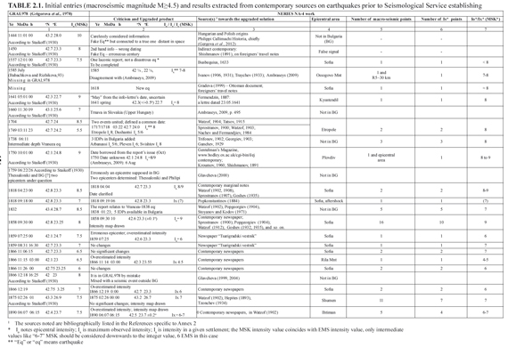
Suggested citation: Glavcheva, R., and Matova, M. 2014. 120th anniversary of seismology in Bulgaria: milestones, development and achievements. Boletín de Geología, 36 (2): 125-158.
The territory of Bulgaria is situated in the eastern part of the Balkan Peninsula, South-Eastern Europe, being a part of the Alpo-Himalayan seismic belt. The most important cities in Bulgaria lie in the vicinity of Neogene-Quaternary active faults. Due to these circumstances organized monitoring of earthquakes as well as development of seismological practice started in Bulgaria at the end of 19th century. The foundation of seismology in Bulgaria was laid in 1891 by the meteorologist and also the first Bulgarian seismologist Spas Watzof, later honored with academic rank. Spas Watzof founded and organized a well managed service for regular observation of co-seismic and post-seismic effects of earthquakes. Soon after, in 1903, Bulgaria was accepted as a member of the International Seismological Association (the predecessor of the International Association of Seismology and Physics of the Earth's Interior - IASPEI). It should be noted that foreign experts demonstrated scientific interest in cases of strong earthquakes that took place on the territory of Bulgaria in the beginning of 20th century (Hörnes, 1904; Grablovitz, 1904; Mihailovich, 1933; Richter, 1958) as well as on using instrumental records made in Bulgaria for their revolutionary discoveries (Reid, 1910; Mohorovicic, 1910). At present Bulgaria participates in international activities in the frames of the European Seismological Commission (ESC) - a regional commission of the IASPEI, the International Federation of Digital Seismograph Networks (FDSN), the Balkan Geophysical Society and the Comprehensive Nuclear-Test-Ban Treaty Organization (CTBTO). On occasion of the 120th anniversary of the seismology in Bulgaria it is reasonably the results of studies covering such a long period and published in international and Bulgarian journals and monographs to be summarized and presented herein. The summary of the milestones, development and achievements in the field of Macroseismology, Instrumental seismology and Geodynamics in Bulgaria is chronologically presented. The paper aims also to spread more effectively the Bulgarian scientific information abroad as well as to popularize some seismic peculiarities and phenomena in the central-eastern Balkan Peninsula.
Keywords: Bulgaria, seismotectonics, macroseismology, historical seismology, instrumental seismology, seismic hazard, regional and world geodynamics.
120° ANIVERSARIO DE LA SISMOLOGÍA EN BULGARIA: HITOS,
DESARROLLO Y LOGROS
RESUMEN
El territorio de Bulgaria está situado en la parte oriental de la península de los Balcanes, al sureste de Europa, siendo una parte del cinturón sísmico Alpes-Himalaya. Las ciudades más importantes de Bulgaria se encuentran en las inmediaciones de las fallas activas del Neógeno-Cuaternario. Debido a estas circunstancias, el monitoreo organizado de terremotos, así como el desarrollo de la práctica sismológica inició en Bulgaria a finales del siglo XIX. La fundación de la sismología en Bulgaria ocurrió en 1891 por el meteorólogo y también el primer sismólogo búlgaro Spas Watzof, posteriormente honrado con rango académico. Spas Watzof fundó y organizó un servicio bien direccionado para la observación regular de los efectos co-sismicos y pro-sísmicos de los terremotos. Poco después, en 1903, Bulgaria fue aceptada como miembro de la Asociación Sismológica Internacional - ISA (predecesora de la Asociación Internacional de Sismología y Física del Interior de la Tierra - IASPEI). Es importante anotar que expertos extranjeros demostraron interés científico en casos de fuertes terremotos que tuvieron lugar en el territorio búlgaro a inicios del siglo XX (Hörnes, 1904; Grablovitz, 1904; Mihailovich, 1933; Richter, 1958), así como en el uso de registros instrumentales hechos en Bulgaria por sus descubrimientos revolucionarios (Reid, 1910; Mohorovicic, 1910). Actualmente, Bulgaria participa en actividades internacionales en el marco de la Comisión Sismológica Europea (ESC) - una comisión regional de la IASPEI, la Federación Internacional de Redes Digitales de Sismógrafos (FDSN), La Sociedad Geofísica Balcánica y la Organización Integral de Tratados de Prohibición de Pruebas Nucleares (CTBTO). La sismología en Bulgaria celebra su 120° aniversario y es razonable que los resultados de los estudios realizados en este periodo tan largo y publicado en revistas y monografías internacionales y búlgaras sea resumido y presentados aquí. Se presenta cronológicamente el resumen de hitos, desarrollos y logros en el campo de la Macrosismología, Sismología Instrumental y Geodinámica en Bulgaria. El documento trata también de difundir más efectivamente la información científica búlgara más allá de sus fronteras e igualmente divulgar algunas peculiaridades y fenómenos sísmicos de la parte centro-oriental de la península Balcánica.
Palabras Clave: Bulgaria, sismotectónica, macrosismología, sismología histórica, sismología instrumental, amenaza sísmica, geodinámica regional y mundial.
The territory of Bulgaria, located in the eastern part of the Balkan Peninsula, is surrounded by lands characterized by high seismic activity and frequent damaging earthquakes that influence the seismic hazard in the country. The Bulgarian territory has originated destructive earthquakes over the centuries. It is remarkable that during the first 30 years of 20th century five earthquakes of magnitude Ms≥7 (Ms is the surface-wave magnitude) occurred in this country reaching magnitude 7.8 in southwestern Bulgaria, 7.2 in northeastern Bulgaria, and 7.0 in southern and northern Bulgaria; the cited magnitude assessments are according to Christoskov and Grigorova (1968). Since then few moderate earthquakes with magnitude less than 6.0 have occurred. The earthquakes in Bulgaria have their foci mainly in the upper crust (down to 30-35 km), and only few events are located in the lower crust (down to 50 km in SW Bulgaria).
The seismology in Bulgaria has been developing for more than 120 years. We summarize the milestones, development and achievements in three main fields in it: (1) Macroseismology, the branch of seismology which studies observable effects of earthquakes on people, objects, buildings, and nature. The macroseismic data ensured a basis for development of the historical seismology and seismic hazard assessment, both of great scientific and social importance and they are also reviewed herein; (2) Instrumental seismology, the earthquakes are registered instrumentally and this circumstance allows widening of the set of earthquake's characteristics and development of new approaches to study the Earth; (3) Seismological contribution in the field of regional and world-wide geodynamics. We review and discuss the chronological development of these three aspects as well as the main tasks and problems that were studied and solved. Before starting discussion on these three aspects we present information on present day seismicity of Bulgaria as well as its spatial relation with the regional tectonic setting.
The territory of Bulgaria is situated in the Balkan Peninsula, South-Eastern Europe and represents a segment of the southern periphery of Eurasian plate. The Bulgarian territory has been exposed to the ongoing collisional process due to dynamic pressure caused by the African and the Anatolian plates. The regional tectonic evolution is also associated with the strong influence of the main neighboring structures as the Mediterranean region from the south, the Carpathian system from the north and the Black Sea from the east. Actually, Bulgaria is in the Eastern European part of the recently active Alpine-Himalayan tectonic belt characterized by expressed seismicity.
The dynamic evolution of the geological structures in Bulgaria has been the subject of numerous publications (Gočev, 1991; Kotzev et al., 2001; van Hinsbergen et al., 2008, etc.). The Alpine orogenic systems of Balkanides, Srednogorie and Rhodopes (FIGURE 1a) developed gradually in the central and southern parts of the country as result of folding, faulting, vertical and horizontal block displacements in the upper part of the lithosphere. The degree of their mobility depends on their position in the Alpine-Himalayan orogenic belt. The Alpine structural genesis was influenced by the local, regional and planetary geological environment. The structures from the Pre-Alpine stages were totally or partially remade. Their traces are included in the Alpine units. According to Zagorchev (1992), during the Neogene and Quaternary time the tectonic processes in Bulgaria were related to the destruction of Late-Alpine orogen, extensional stress environment and complex interaction of intense vertical and horizontal movements in the region. At present, the territory of the country represents mosaics of Alpine structural units and inherited Pre- Alpine relicts. Cenozoic formed structures like horsts, grabens, depressions and basins are found often across the territory.
In the northern Bulgaria a relatively older and stable structural unit of the Moesian platform is situated (FIGURE 1a). The platform represents an epi- Hercinian formation. Paleomagnetic studies of 800 volcanic and sedimentary samples from 12 localities in the Moesian Platform and Bulgarian part of the Rhodopes show existence of unsignificant post-Eocene rotation of these lands with respect to Eurasia. The stability of the studied regions is recently confirmed by van Hinsbergen et al. (2008). The stability could be interpreted as a result of the position of the Balkanides, Srednogorie and Rhodopes in the northern periphery of the Alpine-Himalayan belt and its partial overlapping with the Moesian plate.
Numerous Paleogene-Quaternary and Neogene- Quaternary grabens or basins were developed generally in central and Southern Bulgaria. The horsts on the boundaries of the grabens had reached considerable heights (relatively higher rate of vertical displacements), mainly in SW Bulgaria (around 2mm/yr uplifting and to 3mm/yr subsidence). Numerous Tertiary-Quaternary faults cut the territory of Bulgaria (FIGURE 1b). Numerous geologists and geophysicians have provided information about recent active faults (Boncev and Bakalov, 1928; Mihailovic, 1933a; Gočev et al., 1984; Gočev and Matova, 1989; Matova, 2000, 2003; Botev et al., in Sledzinski /ed./, 2000a; Matova et al., 2003). Prevailable part of the active faults is presented by normal faults, very often with equatorial and subequatorial direction. The reverse faults and napes have more local distribution. More information about geodynamical circumstances in Bulgaria is presented further in this paper.
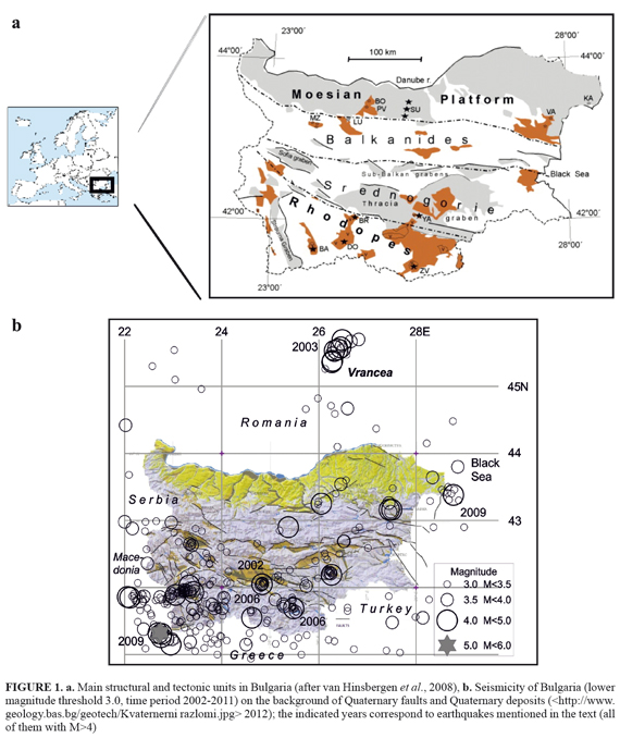
Juxtaposition of the tectonic setting to the seismicity pattern over the territory of the country would be of use for recognition which of the faults being considered as active, are also seismogenic at present. To this purpose, earthquakes registered in the national instrumental network during the last decade are extracted from the seismological database. The lower magnitude threshold of the data sample is chosen to be 3.0; the weaker seismic shocks are neglected due to their dispersed occurrence in space. Thus, the resulting dataset consists of 345 earthquakes that occurred from 2002 to 2011 including and are of magnitudes in the range 3≤Md≤5.3. Distributed in depth, they occurred down to 20 km in Bulgaria and nearby territories, only the Vrancea seismic source in Romania originated intermediate depth earthquakes (11 shocks) with maximum depth of 160 km. It should be noted that the vertical size of the Vrancea seismogenic volume is of about 80-100 km while its earthquake epicentres form a very compact area.
During the studied decade the territorial distribution of seismicity in the region bound by geographical coordinates 41-45.7°N, 22-29.5°E is irregular (FIGURE 1b). The frequency of seismic generation decreases towards North-East. The highest seismic activity, as usual, is observed in the south-western part of Bulgaria and the close neighbouring territory where the strongest earthquakes (Mw 5.3 and 5.1) occurred in the border area between Bulgaria, Macedonia and Greece. To remember that in the same border region a doublet of earthquakes occurred in March 1931 (Ms 6.0 and 6.7 according to Shebalin et al., 1974). At about 70-80 km to the north the earthquake epicentres form a close to W-E trending strip, where the maximum of seismic frequency over the territory of Bulgaria is observed and where four of all events of magnitude 4 or higher occurred. The strip of epicentres coincides with the strike of young faults in the region that cross the older NNW oriented first order fault system. It should be noted that the above discussed seismicity cluster is situated in the epicentral area of the large doublet of earthquakes that occurred in the beginning of 20th century (4 April 1904, Ms 7.1 and 7.8; magnitude evaluation according to Christoskov and Grigorova, 1968). To the west of the noted cluster, outside Bulgaria, the older fault systems that extend to the NNW manifest their seismogenic capability. To the south of the same epicentre concentration, on the territory of Northern Greece, activation is formed along the Middle-Mesta fault system of W-E orientation. And, from the eastern edge of the seismicity strip, continuation of activity is observed in two directions: the first towards ESE into the neighboring Rhodopean massif, and the second trends SSE along the Pirin Mountain known by its relatively rapid uplifting, then with disintegrating consequences. To preclude with the seismic generation in the south-western region of Bulgaria, it should be noted that the northern board of the mountain massif in this part of Bulgaria is sluggish marked by rare seismic manifestations. Obviously, all the Quaternary faults in SW Bulgaria were seismogenic during the considered period, i.e. from 2002 to 2011.
To the North of the above considered territory of Bulgaria, the territory of central West Bulgaria is situated. It is cut by Quaternary faults stretching in ESE-WNW direction. Here, two areas show seismic activation during the considered time period. The first, of SE-NW orientation, is situated to the south of the capital city of Sofia, the second lays in the border region between Bulgaria and Serbia and is of W-E orientation. The maximum observed magnitude in central West Bulgaria for the studied period is less than 4.0.
The central South Bulgaria is the territory wherein two destructive earthquakes (Ms 6.8 and 7.0) occurred in 1928. During the study period the seismogenesis therein was at a very low level. Only the seismic activation in April-May 2002 (mainshock's magnitude Md=4.2) perturbed the seismic pattern of the northern flank of the Rhodopes Mountain that cover the southern part of central Bulgaria. In the eastern Rhodopes a seismic sequence with a mainshock of magnitude Md=4.5 was observed in 2006. It can be seen in FIGURE 1b that the seismically activated area was along a Quaternary fault of ESE-WNW orientation.
In the south-eastern Bulgaria the seismicity shows a dispersed pattern with exception of the most eastern area where numerous earthquakes have occurred since 2009. It should be noted that a two-year period of similar seismicity characterized by slightly perceptible earthquakes was observed there in the beginning of the 20th century (starting in 1907).
The central North Bulgaria is the area where the 1913, Ms7, earthquake and the 1986 moderate earthquakes (Md 5.4 and 5.7) took place. However, during the last 10 years it generated few shocks only and comments on the relation with the tectonic setting would be fictional.
The North-East Bulgaria shows scanty seismicity, typical of it. Two seismic sources should be noted therein: (1) the surroundings of Provadia salt mining area with concentration of shallow earthquakes of magnitude less than 4.5 (Dimova et al., 2004; Botev et al., 2005) and (2) the continental slope contacted with the Black Sea known by generating a magnitude Ms7.2 earthquake in the very beginning of the 20th century (March 1901). The present-day seismicity of the latter source is low though two seismogenic orientations there are noticeable - WNW-ESE and NNE-SSW. The maximum magnitude during the examined decade was 4.8 on 5 August 2009, hypocentre under the sea, maximum intensity on the land 6 EMS.
Generalizing, at present there exist seismically active Quaternary faults and blocks between them. Most active among them are the structures in SW Bulgaria and the contact lands in Bulgaria, Macedonia and Northern Greece. The degree of seismic activity in the rest of the faults and blocks shows difference even for a 10 years period of instrumental registrations. Nevertheless, some general trends in the territorial seismogenesis can be outlined as follow: W-E (in SW Bulgaria and the neighboring Macedonia, W Bulgaria, N Greece) and quite close to it WNW-ESE (in central South Bulgaria, Rhodopes, NE Bulgaria) on the one hand; almost N-S that coincides with the old structures (in SW Bulgaria: NNE-SSW and NNW-SSE; the neighboring Macedonia NNW-SSE); WNW-ESE (in N Rhodopes) and SE-NW (in W Rhodopes). This seismic activity pattern provides important information about the recent block differentiation.
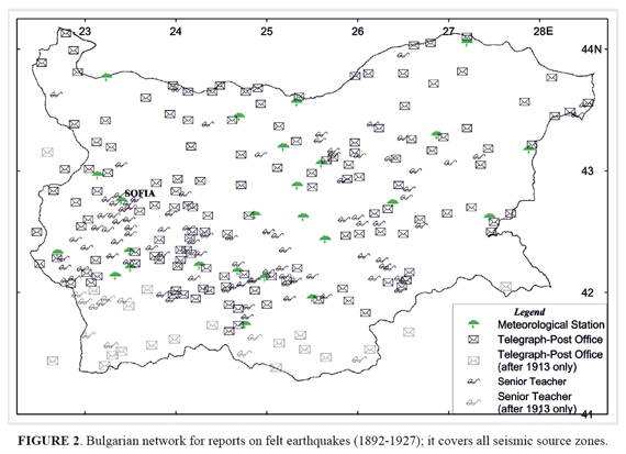
The seismology in Bulgaria dates back to 1891. Its pioneer and director of the Central Meteorological Station in Sofia was Spas Watzof. He organized a network of correspondents-volunteers for observation of felt earthquakes (shocks detected by people without instruments irrespective of their strength). The observation macroseismic network consisted of meteorological observatories, telegraph-postal services, railway station officials, municipal offices and teachers (FIGURE 2). To unify the collected reports Watzof prepared and spread over the country a special "Instruction and program on the earthquakes observation and documenting" (Watzof, 1902). The Bulgarian seismological service was committed to collect, analyze and archive macroseismic information about affects that accompany and follow felt earthquakes. The telegraphically received information often served to warn local governors about possible aftershocks in the earthquake area. Until 1912 the seismological office had also to collect macroseismic information from Bulgarian lands that remained under Ottoman administration. All the reports coming to the Central Station were systematized and after that included in seismological compilations "Reports on the Earthquakes felt in Bulgaria".
Macroseismology in the pre-instrumental period was concerned chiefly with the observational use, for seismic monitoring and construction of macroseismic bulletins. Except for the correspondents' descriptions, Watzof's "Reports" contain a tabulated systematics of the observed effects being supplemented by reported intensity assessment. Thus, Watzof formed the proto-type of a macroseismic bulletin in Bulgaria. This manner of presentation holds to the earthquakes felt in Bulgaria during the period 1892-1927. After Watzof's death in 1928 the employees of the seismological service continued with collecting the macroseismic data. As a result of their efforts, the scientific world received regularly annual reports on earthquake shakings in Bulgaria in the course of 74 years. In addition, the latter information is very important for completing the macroseismic maps at catastrophic earthquakes in Greece (Low Thracia), Turkey (East Thracia and Asia Minor), Romania (the region Vrancea), Macedonia and Serbia. The same macroseismic set of data ensured later the basis for compilation of earthquake catalogs (Grigorova, 1973, in Shebalin et al, 1974; Grigorova et al., 1978; acknowledgments to R. Glavcheva and D. Sokerova /Bulgaria/ "for presentation of important initial data", in Shebalin et al., 1998) and maps of intensity distribution (the macroseismic maps are discussed below).
The last materials presenting eyewitnesses' evidences are those prepared by Watzof just before his death and later edited and published by Kirov (1931). In the following years Kirov preserved only the form of classical macroseismic bulletin skipping detailed eyewitnesses' statements. The strength of shakings began to be assessed by a specialist and not by correspondents-volunteers as previously. This form was adopted and used until the issue of the last macroseismic yearbook (Grigorova and Rizhikova, 1966).
Over the years, various intensity scales were applied. Intensity value was given by the Rossi-Forel scale - RF (de Rossi, 1883; 1911; the RF scale was published in Bulgaria by Watzof in 1902) till 1912. Further on, the shaking intensity was assessed by Forel-Mercalli 12-degree scale (Mercalli, 1902), it was modified by Cancani (1904) who added two more degrees for catastrophic earthquakes and proposed a peak acceleration value equivalent to each intensity degree). In the course of time modern European intensity scales were adopted successively: the Mercalli-Cancani- Sieberg scale (supplement relying to effects in buildings, Sieberg, 1923) was applied from 1946 to 1960, the Medvedev scale (behavior of different building types, Medvedev, 1953) and its clarifying-upgrading in the scale of Medvedev-Sponheuer-Karnik (Medvedev et al., 1964) were applied to the earthquakes after 1961 and, finally, the EMS-92 and EMS-98 (Grünthal /ed./, 1993; 1998). Here we would like to recall the conclusion drawn from the comparison of macroseismic intensity scales (Musson et al., 2010, p. 422): "… whatever differences there might apparently be in the wording of the scales, there should be no differences in MSK values and EMS values if the MSK values were correctly assigned".
In cases of important earthquakes (according to the consequences or epicentral position) field investigations of effects are usually undertaken. Special volumes have been dedicated to observational data collected in cases of large shocks in Bulgaria. A very well illustrated book is among the works of great value (Staikoff, 1916). It is devoted to the first Bulgarian field inspection that was conducted by Staikoff in the epicentral area of the Ms7.0 North Bulgarian earthquake in June 1913. The epicentral intensity of this event reached IX MSK (EMS98), the shock damaging many villages completely and two important cities partially. Dineva et al. (2002) re-determined the magnitude of this earthquake from a great amount of original records; the result Ms=6.3 is "robust" according to the authors statement and, obviously, much lower than the previous estimate (Ms=7.0 according to Christoskov and Grigorova, 1968).
In April 1928 two catastrophic earthquakes hit a broad area in central South Bulgaria. These two events occurred within a time window of only four days and were of magnitudes Ms 6.8 and Ms 7.0, with epicentral intensity IX and IX-X MSK, respectively; focal depth down to 15 km. These earthquakes were followed by numerous aftershocks during the next four years. The scientific and practical results from field observations undertaken by geologists and construction engineers, with the financial support of local and state governors and especially of the Red Cross, are described in details in DIPOSE (1931). The report was commissioned by the state's government. Its publication was delayed to include the results of the restoration. Jelenko Mihailovic who was in charge of seismology in Belgrad, Serbia, also made a thorough inspection in the suffered area; his conclusions rely predominantly to tectonics and surface geology (Mihailovic, 1933a, 1933b).
The intermediate depth earthquake source Vrancea (from 60 down to 180 km under the earth's surface), which is situated in the neighboring Romania, represents serious threat to the territory of North Bulgaria, especially at epicentral distances of 150-300 km. The catastrophic earthquake that occurred on 4 March 1977 forced many specialists in tectonics, geology, seismology and earthquake engineers to undertake field surveys of the consequences caused by the event. According to the Romanian Earthquake Catalogue ROMPLUS (2007), the earthquake moment magnitude was Mw=7.4; the Mw value was assessed by the moment magnitude scale (Kanamori, 1977; Hanks and Kanamori, 1979). Results from the thorough field work on the effects of the 1977 destructive earthquake as well as essential seismological information on the Vrancea region seismicity (deep events recurrence, response spectra, intensity attenuation, etc.) were published in the monograph compiled and edited in Bulgarian Academy of Sciences (Brankov /ed./, 1983).
The monitoring application of intensity is of significance for studying currently felt seismic events. The nowadays macroseismic practice in Bulgaria includes the following procedures: phone interviews, internet questionnaires' dissemination and field survey. The field observations carried out immediately after the occurrence of a strong earthquake, not influenced by its aftershocks, give knowledge not only on the earthquake that already occurred but also ensures a basis for developing a scenario for future distribution of the seismic effects. Inspections are accomplished by teams of seismologists, earthquake engineers and specialists in geology. With the local authorities on the spot, the team firstly looks for generalized information concerning the state-of- the-art of the building stock (typical damage and top damages), terrain and soil peculiarities, infrastructure, systems supplying electricity and drinking water, circumstances in the settlements and their surroundings (Glavcheva and Matova, 2009). It is very important to give the people information about the occurred event/-s as well as preliminary advices related to their estate. This ensures psychological support to the population. Public buildings like schools, libraries, cultural and sport buildings, etc., need special attention. After precluding the inspection, the most frequently observed damages and other effects are systematized and assessed. Reports are delivered to The State Agency for Civil Protection and the local governors.
Isoseismal maps in Bulgaria came officially into practice since 1952 (Ileff, 1952). Macroseismic maps for Bulgarian earthquakes of magnitude Ms≥4 that occurred till 1970 (77 maps, minimum epicentral intensity of V MSK) are presented in the Balkan Region Atlas assembled and generalized by Shebalin (1974). Most of this material was previously published in Bulgaria (Grigorova and Grigorov, 1964). Additionally, isoseismal maps of Bulgarian earthquakes can be found in the atlases published by Prochazkova and Karnik (1978), Glavcheva (1993) and in papers devoted to damaging earthquakes in the seismic zones of Bulgaria. For instance, a comprehensive study of the intensity distribution from earthquakes of the same source was provoked by a seismic event of magnitude 5.7 in 1986 (Glavcheva, 1989). Another case of necessity to survey and generalize consequences of earthquakes is in an area with salt mine production in East Bulgaria (Dimova et al., 2004).
Bulgaria is under the influence of seismic impacts from the neighboring countries too. Especially the intermediate depth earthquakes from Vrancea, Romania, with magnitude higher than 7.0 (37 earthquakes of magnitude Mw≥7.0 according to ROMPLUS) usually cause great losses to the territory of North Bulgaria. The 1977 Vrancea earthquake of magnitude Mw=7.4 (evaluation in ROMPLUS) led to partial or complete destruction of about 8500 buildings and killed 125 people in Bulgaria. On this reason, the entire set of intensity maps for Bulgaria in cases of large Vrancea earthquakes was subjected to macroseismic quantitative analysis specifying the intensity attenuation towards the north-west and north-east Bulgaria (Grigorova et al., 1978; Glavcheva, 1983). The isoseismal maps of next destructive Vrancea earthquakes on 30 August 1986 (Mw=7.1 according to ROMPLUS) and 30 May 1990 (Mw=6.9, ROMPLUS), containing intensity data points, are presented by Evlogiev et al. (2010) and Bonjer et al. (2010). It should be noted that in the case of November 1940 earthquake (Mw=7.7, ROMPLUS) Romanian authors have assigned various intensity assessments to one and the same site without reference for the used macroseismic scale; this resulted in several modifications of isoseismals. Thus, the unification of the intensity field in the border areas between Romania and Bulgaria is a necessary task that has to be accomplished in the near future.
Historical seismology
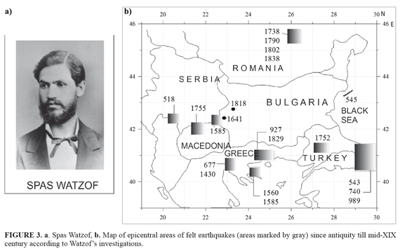
One of the mandatory requirements for proper assessment of seismic hazard is to conduct a careful and critical evaluation of catalogues that include earthquakes occurred in earlier centuries (the so called historical earthquakes). Development of the historical seismology is impossible without using of macroseismic approaches. The pioneer of historical seismology in Bulgaria was Spas Watzof. He organized intellectuals in Bulgaria to collaborate in searching for information on tremors that occurred in the past. Watzof himself brought useful information on past earthquakes in Bulgaria and surroundings from sources dating back to the 8th century (the Chronographia by Theophanes). Most of the epicentre locations indicated more than a century ago by Watzof (FIGURE 3) were confirmed later and, only, presented more precisely in a modern way (See ANNEX 1). The comparison with recent catalogues and studies shows that even nowadays sources are not in full agreement in their evaluations of either the magnitude or intensity of excitation.
The next seismologist who had significant contribution for studying the long-term seismicity was Staikoff. He searched for information about unknown earthquakes through ancient and recent literature, catalogues, periodicals, etc, in Central European libraries. His findings published in (Staikoff, 1930) include 375 earthquakes or clusters that occurred all over the Balkans and in Asia Minor, rarely in Italy, during the time period III c. BC - 1885. His data were used later at the joint compilation of the earthquake catalogue of the Balkan Region (Shebalin et al., 1974).
Almost a century after the pioneering efforts of Watzof, a new search for earthquakes in the past was commenced through different kinds of compilations (historical sources, marginal notes, memoires, and manuscripts). A thorough work fulfilled by Babachkova and Rizhikova (1993) led mainly to first hand sources. Unknown weak earthquakes in Bulgaria and pieces of data on strong earthquakes in the neighborhood were found.
The earthquake catalogues are advanced expression of seismic inventory. However, very often data from a given catalogue that are loaded with errors due to both incorrect interpretation and misunderstanding of the source of information are included in subsequent catalogues. For the seismicity of Bulgarian lands two catalogues have been prepared in the last 40 years. The earlier one was a product of the Project on Seismicity of the Balkan Peninsula (Shebalin et al., 1974). For earthquakes in the past it points to the information sources and frequently quotes corresponding descriptions. The second catalogue was created in connection with the seismic zoning of Bulgaria (Grigorova et al., 1978, further marked as GRAL978). In GRAL978, the historical earthquakes are presented as parameterized entries. Unfortunately, this catalogue also inherited some of the above mentioned disadvantages.
The primary sources of information in GRAL978 are the late compilations of two Bulgarian seismologists Watzof (1902, 1908, 1912) and Staikoff (1930); "late" means that they are second-hand sources retelling stories or citing another unoriginal source. These circumstances forced the Bulgarian team as a participant in the NA4 module "Distributed Archive of Historical Earthquake Data" of the Project "Network of Research Infrastructures for European Seismology" (NERIES, No.026130), Sixth Framework Program of the European Commission, to critically reconsider the way of analyzing and proceeding the collected by Watzof and Staikoff information.
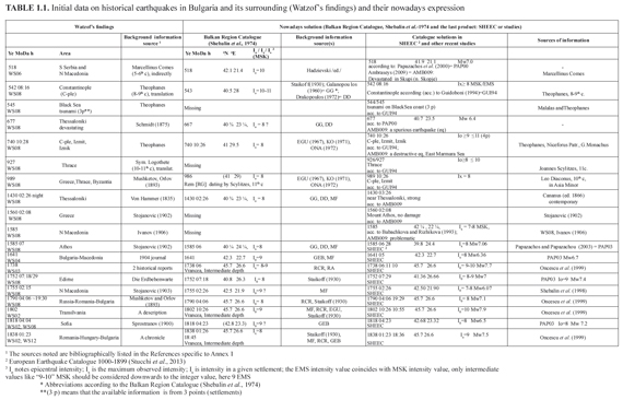
The analysis started from "what was known" and this was the catalogue GRAL978 together with the corresponding information source (ANNEX 2). The bibliographic lists presented in the cited Bulgarian compilations helped for finding out earlier information. The catalogue entry corresponds to the time prior to the Seismological Service establishing and earthquakes of a macroseismic magnitude Mms≥4.5 according to the information given by the catalogue GRAL978. The catalogue entry provided by GRAL978 (ANNEX 2: column 1 in Table 2.1) is examined in this study by information sources coeval to the corresponding seismic event (column 3; reference lists of these sources have been added to ANNEXES following this main text). By the above described procedure the identity of corresponding earthquake is verified and the catalogue macroseismic parameters upgraded. Column 2 of Table 2.1 contains the main critical remark to the established state of affairs together with the resulting entry if determinable.
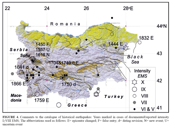
As a result of the analysis of information sources (e.g. historic, diplomatic, ethnographic, travel literature, and newspapers issued in the second half of the 19th century) coeval as much as possible to each of the considered earthquakes, 25 events in the period 15th century-1891 have been revised. Some of them are proved to be fake (1450), some are erroneously localized on the territory of Bulgaria (1444, 1660, 1759, 1832 and 18 Dec. 1866), one new event is added (1618), two events are unified (1704 and 1749), others have received corrections of dating, or epicentre determination or, most often, intensity value (FIGURE 4). Corrections are owed presumably to careless reading of information (ANNEX 2). The critical re-evaluation of the macroseismic archive of earthquakes felt in Bulgaria can be considered as an improvement of the knowledge on historical seismicity.
Studies on seismic hazard
The seismic intensity is also used at present in a predictive way for seismic hazard and risk studies, where damage and loss estimates can be inferred from expected intensity values. The assessment of seismic hazard and generation of earthquake scenarios is the first step in the evaluation of seismic risk.
The irregular macroseismic effects of the Vrancea intermediate depth earthquakes (depth interval from 60 to about 180 km) are directly included in the seismic hazard calculations for Bulgaria and adjacent territories framed between 41-45°N, 22-30°E (Simeonova et al., 2006). The probabilistic seismic hazard assessment in terms of intensities (probability that various levels of intensity will be exceeded during a certain period at a given site) is performed following Cornell (1968) with the program EQRISK (McGuire, 1976). Two factors suggested the use of macroseismic intensity instead of peak ground acceleration or spectral acceleration: the direct correspondence between intensity of shaking and the degree of damage, and the intensity as being the original parameter of historical earthquakes. The intensity-frequency relations and the site intensities are computed as a function of observed MSK epicentral intensities based on a catalogue for the whole area (Shebalin et al., 1998).
The seismic hazard maps have been later updated by Leydecker et al. (2008) dealing separately with the shallow earthquakes over the whole study territory and the intermediate depth's earthquakes from Vrancea. The seismic hazard evaluation has been obtained following the same methodology for the entire territory of both, Bulgaria and Romania, and according to the requirements of the European earthquake building code EUROCODE 8 (EC 8). Calculations are done for recurrence periods of 475 years (probability of exceedance of 10% in 50 years) for the design earthquake and 95 years (probability of exceedance of 10% in 10 years) in order to limit the damage of buildings and the financial loss in case of weaker earthquakes with higher frequency of occurrence.
It is worth noting that earlier studies on the seismic hazard in Bulgaria (Bonchev et al., 1981, 1982; Orozova- Stanishkova and Slejko, 1994; van Eck and Stoyanov, 1996; Solakov et al., 2001b) used the magnitude-frequency relations and the epicentral or site intensities proceeding from magnitudes. However, the magnitude has been loaded with great uncertainty almost till the 60-ties of the 20th century as a value resulting from intensity. One more remark: only Bonchev et al. (1982) have performed hazard analysis for the whole territory of Bulgaria for different probabilities of exceedance, but not for a 475 years return period as EC8 recommends.
Based on earthquake catalogues, regional seismotectonics and geotechnical zonation, earthquake scenarios (ground motion hazard maps by both approaches: deterministic and probabilistic) for important urban areas in Bulgaria are presented by Solakov et al. (2009). For the capital city Sofia ground shaking accelerations in terms of peak ground acceleration (PGA) and response spectral accelerations in the frequency interval 0.5 - 3.3 Hz were evaluated by a deterministic approach; thus, in the case of local earthquake of magnitude 6.3 the estimated PGA values are in the range 0.05÷0.3 g, and the maximum spectral amplitude is 0.75g at frequency of 3.3 Hz. The probabilistic approach that gives an idea of the pattern of ground motions for future earthquakes was estimated according to the technique accepted in the frames of the European project Risk-EU (2001-2004). Following this technique, the obtained for the capital city Sofia PGA value was in the interval 0.15÷0.28g for bedrock (Solakov and Simeonova, 2006). In practice, similar scenarios are intended as a basic input for devel-oping detailed earthquake damage scenarios for the cities. They can be used in the urban and infrastructure planning.
To generate earthquake damage scenarios for earthquakes of magnitude between 4.1 and 8.0 centered in an arbitrary point in Bulgaria and adjacent territories, the software package Automated System for Assessment of Earthquake Consequences (ASEC) was created and used in Bulgaria (Solakov et al., 2001a). It includes also a previously developed approach for estimation of the possible human losses in case of strong earthquakes (Christoskov, Samardjieva, 1984; Christoskov et al., 1990). The ASEC estimates the statistical mean values of human casualties, building damages and the cost for covering losses. Such estimations are especially helpful for rescue teams after a strong earthquake has struck Bulgaria.
An Advanced Research Workshop "Earthquake monitoring and seismic hazard mitigation in Balkan countries ", financed by the program "The NATO Science for Peace and Security" was hold in Borovetz, Bulgaria 11 - 17 Sep. 2005. Forty two scientists from 22 countries took part in the workshop, including representatives of international organizations like IRIS, ORFEUS, EMSC, MEDNET, CTBTO. The main topics of the meeting included: geology, tectonics of lithospheric plates, tomography of the crust and mantle seismicity, seismic risk and hazard, seismic networks and activities - global, regional and national; operations of global and regional seismic networks. The organizing, managing and implement of the workshop as well as the publishing of the presented lectures (Husebye and Christova eds., 2005) were carried out mainly by the efforts of Bulgarian workshop sci director and the local organizing committee.
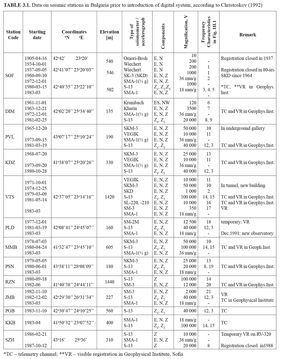
The instrumental seismic monitoring in Bulgaria started after a couple of devastating earthquakes (Ms7.1 and Ms7.8 according to determinations by Christoskov and Grigorova, 1968) that occurred on 4 April 1904 in the south-western part of nowadays Bulgaria. The first seismological station in Bulgaria was opened in Sofia in 1905 where two horizontal components of the mechanical Omori-Bosh seismograph were installed by the young seismologist Staikoff. These undamped pendulums began operating as follows: since 16 April 1905 the EW component, and since 1 June 1905 the NS component. In 1934 two horizontal Wiechert seismographs (eigen period To=9-11 sec; magnification around 200; with air damping) began operating in the capital city. They were in operation along with the electromagnetic type of seismographs till 1980 when the national seismological service of Bulgaria was expanded. The development of the instrumental network in Bulgaria during the 20th century can be traced in ANNEX 3 (data borrowed from Christoskov, 1992).
The actual start of the instrumental seismology in Bulgaria is associated also with the creation and issuing of instrumental bulletins which cover the earthquake records from the following periods: 1905-1911 (Watzof, 1907, …, 1921), 1935-1946 (distributed only in mimeograph), 1947-1956 (Kirov and Grigorova, 1957, 1958) and finally from 1960 until 1965 (Grigorova et al, 1962; Grigorova and Rijikova, 1963; Rizhikova, 1970). It is noteworthy that the records of Sofia seismic station were used in studying the awful 1906 San Andreas, California, earthquake (Reid, 1910) as well as in the examinations on the thickness of the crust by Mohorovicic (1910).
The deployment of instrumental registration in Bulgaria led to development, adaptation and application of new methodological approaches as listed chronologically below:
- Attempts were made to create a local magnitude classification (Grigorova and Grigorov, 1962; Christoskov, 1962);
- The microseismic noise at Sofia station was measured (Christoskov and Holub, 1963);
- A comprehensive microseismic zoning with the participation of professor Medvedev was accomplished to support a dam safety (Medvedev et al., 1963);
- A normalized magnitude scale for near and distant earthquakes was completed (Christoskov, 1964);
- Propagation velocities of surface waves across the Aegean Sea were investigated (Rizhikova, 1966);
- Results on body waves propagation velocities and the Earth's crust structure in Bulgaria were reported (Grigorova and Sokerova, 1967);
- An approach to generalization for the weak earthquakes in Bulgaria was suggested (Rizhikova and Glavcheva, 1974);
- Bulgaria collaborated to compiling the first united earthquake catalogue for the Balkan Region (Grigorova, 1973, in Shebalin et al., 1974);
- P-wave travel time residuals in the Balkan region were investigated (Sokerova, 1974);
- Maps of seismic activity within Bulgaria were constructed (Grigorova and Glavtcheva, 1976);
- Induced seismic activity was proved in the Iskar Dam surrounding (Grigorova et al., 1976);
- Experimental telemetric transmission of analog seismological information between a mountain in surrounding and the building of the Geophysical Institute in Sofia was carried out via ultra short waves in 1978;
- Prognostic seismic zoning of Bulgaria, that became the fundament of the Bulgarian Code for design of structures in seismic regions (1987), was committed and completed by a wide range of specialists in the earth sciences (Bonchev et al., 1981, 1982); many years ago, the first seismic regionalization of Bulgaria was approached by Kirov and Grigorova (1957) based only on seismological background;
- Focal mechanisms for two earthquakes of a medium strength (magnitude up to 5) that occurred in SW Bulgaria were constructed and examined (Georgiev and Ichikava, 1976).
Most of the problems listed above have become later a permanent objective for further studies and development.
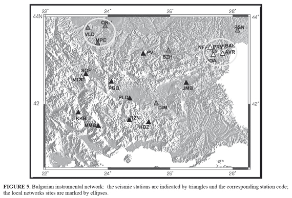
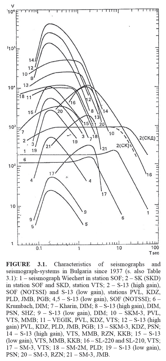
Since March 1980, for about a year, the National Telemetric Seismological System for Information (NOTSSI) was established; inquiry about the network development is available in TABLE 3.1 and FIGURE 3.1, in ANNEX 3. The NOTSSI stations were equipped by Teledyne Geotech with short-period seismographs S-13, with a frequency band 1.25-10 Hz (0.1-0.8 sec). By simultaneous operation of low and high gain channels, a station dynamic range of 80 dB was achieved (Samardjiev et al., 1980). In the course of time the telemetry network has been expanded to 14 basic registration sites (all of them with vertical S-13) with real time signal transmission to the Geophysical Institute, Sofia, ensuring continuous monitoring. Additionally, two networks for local monitoring of seismicity started operating in the mid-1990 in connection with the seismicity observation around a NPP site in NW Bulgaria (since 1993) and a salt deposit exploitation site in NE Bulgaria (FIGURE 5).
Naturally, a number of studies were carried out on the capabilities of the new registration system: finding out the optimum equipment magnifications for detecting first motion of P body waves from short distance earthquakes in Bulgaria and some other related problems (Rangelov and Christoskov, 1980; Danev, 1982), determination of station corrections in a network of standard seismic stations (Christoskov and Venedikov, 1986), development of a classification for express magnitude evaluation by the short period seismographs S-13 (Samardjieva, 1991), identification of natural and artificial sources (Christoskov et al., 1986; Riznichenko et al., 1987; Milev and Christoskov, 1988), etc.
The presence of well arranged network (Solakov, 1991; Glavcheva et al., 2003; Botev and Glavcheva 2003) ensuring qualitative instrumental records resulted in gradual liquidation of non-uniform parameterization of earthquakes. Based on the methodological principles and practical results developed by Chalturin and Christoskov (1974), Karnik and Christoskov (1977), Christoskov et al. (1978, 1985), Christoskov achieved unification of the magnitude determinations from various types of seismic waves for Bulgaria making them compatible with the standard surface wave teleseismic magnitudes.Thus, he constructed calibrating curves for P, S and L waves for shallow events at a depth down to 60 km at short epicentral distances (<10°) for the short and medium period seismographs (Christoskov, 1994). These new calibrating functions turned out especially necessary after installing the short-period Teledyne Geotech devices in Bulgaria.
The high sensitivity of recording in the NOTSSI stations as well as the very broad-band characteristics of the MEDNET station VTS ensured a basis for further examination of the seismic behaviour in various seismic zones and studies on the Earth's structure. Numerous problems became possible to be studied and successfully solved, moreover at a higher level as the following:
- Regular compilation and dissemination of reports on current seismicity observed in Bulgaria and nearby territories (Botev et al., 1991, ..., 2010; Botev et al., 2006b);
- Specification of aftershock manifestations in time after remarkable events according to the modified Omori formula and maximum likelihood method (Simeonova et al., 1988; Simeonova and Solakov, 1999);
- Development and yielding practical results of a dislocation model for determining some basic geometrical parameters of extended earthquake sources by the body-waves time difference between the amplitude maxima and the starting points of the records (Christoskov et al., 1990);
- Solving of earthquake focal mechanisms for particular seismic zones - for instance, Dineva et al. (in Sledzinski /ed./, 2000b) obtained fault plane solutions for numerous small and moderate shocks that occurred during 1972-1993 in SW Bulgaria and its surroundings (40.8°N÷42.4°N and 22.0°E÷24.2°E); the results may be summarized as follows: 60 % of the solution type is the normal type, around one third of solutions are of reverse type and only 5% of the events are with horizontal movement along the fault. The authors suggested concordance with the regional sub-horizontal tensional stress;
- Discussing the stress distribution over the entire territory of Bulgaria and geodynamical knowledge: Analysis of a homogenized set (unified presentation after checking and/or a re-calculating) of focal mechanisms for 158 earthquakes of magnitude M> 3 that occurred during 1980-2000 in Bulgaria yielded to the following results (Botev et al., 2006a): concerning the territorial distribution, the relative share of the dominant focal solutions, namely of those ones of a normal type, decreases from SW towards NE (the rest of the contributions refers to the geodynamics and are discussed further);
- Obtaining of spectral characteristics of seismic waves directed to outline the site specificity of seismic danger (Deneva, 1985);
- An anisotropic layer at depths of 30-45 km was identified in southeastern Europe based on the records of very broadband seismometers and the dispersion properties of Rayleigh and Love surface waves (Raykova and Nikolova, 2003); frequency-time analysis and the Backus-Gilbert inversion method (1968, 1970) were applied;
- The heterogeneity of the crust and upper mantle for the territory of Bulgaria was proved according to seismic data (Botev and Vinnik, 1984; Botev et al., 1987; Spassov and Botev, 1987, 1989)
- Ideas on interaction between neighboring seismic zones (sources of trigger effects) were examined on the purpose to understand the tectono-physical mechanism of the earthquake generation (Gospodinov and Rotondi, 2006; Papadimitriou et al., 2007);
- Searching for earthquake precursors, like: changes of the properties of the earth's medium based on the examination of body waves particle velocity (Yelenkov and Stoyanov, 1986); anomalies in the ionosphere by land measurements (Nestorov, 1979; Ralchovski and Komarov, 1987, 1989); anomalies in the ionosphere by satellite monitoring (e.g., Gousheva et al., 2008); anomalies based on geomagnetic monitoring (Botev et al., 2007), and on seismological features in earthquake zones.
Bulgaria has gained extensive experience throughout participation in accomplishment of international initiatives on testing advanced methods and techniques for data acquisition and processing, most often on a multidisciplinary basis - it comes to European and bilateral projects as well as other joint activities: "Genesis and Impact of Tsunami on European Coast " (GITEC, 1993-1995), "Assessment of seismic potential in European large earthquake area" (ASPELEA, Oct. 1997-June 2000), "An advanced approach to earthquake risk scenarios, with applications to different European cities" (RISK-UE, 2001-2004; subcontract "Seismic hazard assessment and ground motion scenarios for the city of Sofia"), "Developing existing earthquake data infrastructures towards a Mediterranean-European Rapid Earthquake Data Information and Archiving Network" (MEREDIAN and Amendment to MEREDIAN, 2000- 2006), Field Investigation Team for severe earthquakes in Europe and the Mediterranean basin with European Seismological Commission (FITESC, since 2002), "Natural and Environmental Disaster Information Exchange System" (NEDIES, a project conducted by the Protection and Security of the Citizen, IPSC, of the EC Joint Research Centre, JRC, 2006), "Network of Research Infrastructures for European Seismology" (NERIES, 2006-2010; subcontract), "Seismotectonics and properties of the strong earthquake sources" and "Analysis of the tectonic and the seismicity of strong earthquakes focal zones" (bilateral with Pacific geographical institute, Russian Academy of Sciences - The Far East Division, 2002-2004 and 2006), "Seismogenesis and interactions between earthquake sources in the Southern Balkans" (bilateral Bulgaria- Greece, 2005-2008), "Seismic hydrogeological vulnerability of the environment and the society in the Balkan region" (Balkan Project, UNESCO-Bulg. Acad. Sci., 2004-2012; see Matova, 2004), and others.
The modern instrumental seismological equipment in Bulgaria
The upgrading of the National Seismological Network (NSN) started in 1996 when a station close to Sofia was equipped with STS-1 and Quanterra 380. Two more stations in South Bulgaria were supplied with Quanterra 330 data loggers and Guralp CMG-40T broad-band sensors in 2003. The participation of Bulgaria in the European project MEREDIAN-2 involved NSN into the broadband European network. Thus, since 2004 the real-time data transmission from the above three stations became available via digital telephone lines.
In 2005 the modernization of the NSN by means of digital technology was completed. Nowadays the upgraded NSN consists of 13 stations equipped with REF TEK High Resolution Broadband Seismic Recorders (DAS 130-01/3) and one station with Quanterra 680 recorder; the sensors are of different type - VBB STS1, STS2, KS2000; BB CMG 40T and CMG 3ESPC; SP S-13; accelerometers REF TEK 131/03 (Solakov et al., 2011). The peripheral stations transmit seismic data continuously to the National Data Centre (NDC) for analysis and archiving (Dimitrova et al., 2006). The real-time data flow transfer is performed via the network of the Bulgarian Telecommunication Company (BTC), using optical line from the BTC centre to the central seismological site in Sofia. Additional advantages of the real-time acquisition and processing are avoiding loss of data as well as interfering of a station noise; details are expressed by Solakov et al. (2011).
Data from the Quanterra recorder and foreign stations are collected and simultaneously transferred to MEDNET and NEIC in real time using the SeisComp/ SeedLink software. Regional real-time data exchange between Bulgaria and Romania, Macedonia, Serbia and Greece is continuously going; it complements the data set for localization of seismic events. The source parameters that are provided automatically may be reviewed by the seismologist on duty thanks to the possibility to accomplish express manual relocation operating with the wave forms. However, the magnitude estimation algorithm needs further tuning. Thus, in the latest 2005 the NSN switched from analogue, short period one component recording to 3-component, broad-band on-site digital recording, automatic processing and digital data analyses. At present the NSN is a reliable broad-band digital network which accomplishes real-time seismic monitoring and disseminates earthquake solutions via internet http://ndc.geophys.bas.bg/, under the management of eng. Stoyanov.
The National seismological Data Center /NDC/ is the only unit in Bulgaria authorized for acquisition of seismological information. In cases of earthquakes felt on the territory of Bulgaria, the information is transmitted to the government authority, mass media and population. Information on strong felt earthquakes is directed also to the Field Investigation Team of European Seismological Commission.
Immediately after the 1928 mainshocks (Ms 6.8 and 7.0 according to Christoskov and Grigorova, 1968) presence of coseismic ruptures of 105 km total length on the earth surface was reported. This information can be found in the monographs (DIPOSE, 1931; Mihailovic, 1933a, 1933b). The earthquakes also produced a large subsiding area in the Maritza valley, South Bulgaria, with the formation of several temporary lakes and landslides. Before (1923-1927), by chance, and after (1929-1930) the1928 large earthquakes the National leveling network conducted leveling service providing very important information about elevation changes related to the destructive earthquakes. The accuracy of the collected leveling data was estimated as better than 1cm by Mirkov (1932). These data, after appropriate analysis, contributed for clarifying the geodynamical factors in the Upper Thracia, South Bulgaria, even during the next tens of years (Jankow, 1938; Dimitrov and Ruegg, 1995). Fault plane solutions published for the greater 1928 mainshock (Ms7.0) from Glavcheva (1984), VanEck and Stoyanov (1996), Dimitrov and Ruegg (1995) indicated a WNW-ESE oriented normal fault with a dextral strike-slip component.
It should be noted that Charles Richter in his Elementary seismology (1958) especially emphasizes the geodetic procedure connected with the 1928 Bulgarian earthquakes and recommends the used approach for further data acquisition and processing.
Recently, a monograph devoted to the 1928 South Bulgarian earthquakes was compiled by a multidisciplinary team of Bulgarian scientists (Sledzinski /ed./, 2000a). The basic problems included in the monograph are related to: seismological, geological and geodetic investigations; complex interpreting; protective measures. The problems solved in the field of seismology related to geodynamics are as follows:
- Evaluation of the source size, released elastic energy, seismic moment, and relative displacement for each of the two 1928 strong earthquakes. On the basis of author's relations and worldwide data generalization, Christoskov (Sledzinski /ed./, 2000a) estimated the above mentioned source parameters as follows: 56 x 18.6 km and 77 x 24.5 km for the Ms6.8 and Ms7.0, respectively; 7.1 1014 and 2.7 1015 Joules; 1.9 1019 and 5.8 1019 Nm; and 93 and 157 cm.
- Evaluation of the peak ground acceleration in the epicentral regions separately for the two events. Using the root mean square acceleration, Paskaleva (Sledzinski /ed./, 2000a) obtained maximum horizontal acceleration over 550 cm/sec2 and more than 650 cm/sec2 for M6.8 and M7.0 respectively; maximum vertical acceleration ~300 cm/sec2 and ~350 cm/sec2.
- Searching for seismic precursors by analysis of the space-time behaviour of seismicity during the last four decades. Most important findings referring to earthquakes of magnitude Mms ≥4.5 (Mms is the macroseismic magnitude) were that they stopped occurring as follow: about 26 years prior the two main events in the activated by them area; for some 13 years in an area 4 times greater than the size of the future aftershock area; and no one shock was documented in the Ms6.8 source volume for the preceding six years (Glavcheva et al., in Sledzinski /ed./, 2000a).
A bit later, a monograph on the couple of devastating earthquakes (Ms7.1 and Ms7.8, according to Christoskov and Grigorova, 1968) that occurred in April 1904 in the Krupnik-Kresna region, south-western Bulgaria, was compiled (Sledzinski /ed./, 2000b). Several important seismological results can be highlighted as follow.
- The energy-time distribution of the shocks of Ms≥4.5 during the first 100 minutes that occurred after the Ms7.1 earthquake showed that the 23 minutes time interval in-between the Ms7.1 and Ms7.8 earthquakes should be divided into two sub-intervals characterized by different energy release: the energy released during the first time interval (11 min) equals the maximum energy released within the whole considered time period of 100 min, while during the second one (12 min) earthquakes of Ms≥4.5 were not observed, i.e., the second period indicates for presence of seismic quiescence. Another characteristic feature of the energy-time distribution is that after the second large shock of Ms7.8 earthquakes occurred rather rarely (Glavcheva, in Sledzinski /ed./, 2000b).
- Another problem concerning the two very strong earthquakes in April 1904 in the Krupnik-Kresna region is related to their dynamic characteristic, the magnitude. As mentioned above, according to Christoskov and Grigorova (1968) the magnitudes Ms of the two devastating shocks are 7.1 and 7.8. Ranguelov et al. (in Sledzinski, 2000) suggest the magnitude value either ~7.8 evaluated from macroseismics, instrumental data and seismic source dimensions, or 6.4-6.7 according to the recurrence graph, neotectonics, geodetic data, stress field inversion; the coseismic deformations and duration of the aftershock sequence give wavering results. Later, the reappraisal of instrumental data resulted in significantly lower magnitude estimates: Ms=6.8, Ms = 7.2 (Ambraseys, 2001) and Mw=6.8, Ms = 7.2 according to Dineva et al. (2002), instead of the former ones Ms=7.1 and Ms=7.8.
- Because the Krupnik-Kresna earthquake zone in southwestern Bulgaria shows the highest seismic activity in the country, deserved attention is paid in the monograph to now existing low seismicity, once the aftershock realization has passed. For instance, Dineva et al. (in Sledzinski /ed./, 2000b) studied the seismicity in a large area around the Krupnik- Kresna zone situated between geographical coordinates 40.8°N÷42.4°N and 22.0°E÷24.2°E for the period 1985-1993. From a dataset consisting of 3705 earthquakes of magnitude less than 5.1 the authors found out that the seismicity in the region is characterized by clusters related to boundaries between subsiding and uplifting areas.
Aiming to study the seismic sequences of two moderate earthquakes (ML5.4 and ML5.7) that occurred in central North Bulgaria at the southern edge of the Moesian Platform in 1986, a combined seismic data set from the Bulgarian and Romanian telemetric networks was used (Oncescu et al., 1990). A joint hypocenter determination, composite focal mechanism and regional stress tensor inversion were carried out as well as the source areas and fault dislocations were estimated. The results show that the two seismic sequences took place at the intersection of two E-W trending faults (one of them being the Pre- Balkan Fault) with a secondary fault of SSE-NNW trend. In the two sequences, the main shocks originated from unilateral downward faulting on the secondary fault and on the Pre-Balkan Fault, respectively.
The results obtained are supported by tectonic models of the region (e.g., Bonchev et al., 1982) and indicate that in 1986 the southern part of the Moesian Platform slipped with about 15cm oblique downward.
For the territory framed in South Bulgaria and northern Greece an international team with Bulgarian participation suggested that the east-west trending faults show evidence for dip-slip movement only and there is little field data to support strike-slip displacement on most of the faults. And some faults of north-eastern and north-western strike show evidence for strike-slip (Burchfiel et al., 2000). An example for presence of a NW-SE strike-slip movement was documented as a co-seismic effect in the epicentral area of the M7.0 South- Bulgarian earthquake in 1928: a water-fall formed by normal faulting with a dextral strike-slip component appeared through Tcherkezitsa River, a tributary of the great Maritza River (Petrov and Glavcheva, 2007, after a photography in DIPOZE, 1931). Similar results were obtained by Dineva et al. (in Sledzinski /ed./, 2000b) for the south-west Bulgaria and contact areas in Macedonia and Greece. These researchers concluded on the basis of focal mechanism solutions that the predominant quantity of seismic shocks being of a normal type (60% of the whole set) were originated by the fault units oriented in almost W-E direction while a very small quantity of the events (only 5% of 178 earthquakes) were associated with faults oriented NNW-SSE. Explanation for such a spatial distribution of the focal mechanisms the authors found in the existence of a regional sub-horizontal tension stress (normal type of mechanisms) and, at weaker earthquakes, the influence of local stresses (the reverse type solutions and those cases with a strike-slip component).
In geodynamical aspect, a special attention was paid to the seismically obtained stress field that created the discussed focal mechanisms of 158 earthquakes spread over the territory of Bulgaria and nearby areas. In result of modelling of the regional stresses and strains compared to the obtained fault plane solutions, the suggestion of Botev et al. (2006) is: in each of the seismic zones extensional sub-horizontal stresses dominate, i.e. there are situation of normal focal mechanisms; indirectly, it is estimated that the magnitude of the principal stresses in the individual zones vary significantly - an indication of inhomogenity of the Earth's crust; the maximum tension is close to horizontal and towards the NNE or NE (NNW in central North Bulgaria), and maximum compression is almost vertical and of various orientation (E-W in central North BG, ESE in NE Bulgaria, NE in South Bulgaria); differently, the compressional stresses in Krupnik-Kresna zone and surroundings are obtained of ENE orientation but significantly oblique and in the Rhodopes Mountain they seem to be horizontal with a strike E-W extracting from a very small amount of solutions. A mismatch is found between the major axes of the stress and the respective major axes of the strain. According to the authors, such disagreement is characteristic for lands of long-term active tectonics with presence of weakened structures in consequence.
Studies on the present-day geodynamics in world-wide Wadati-Benioff zones (WBZ) are carried out to examine their contemporary geodynamics. The stress distribution in the Wadati-Benioff zones pre-determines all the structural processes in the zones of subduction that are especially remarkable with their seismic activity and tsunami generation along the Pacific ring. The milestones prompting these studies are as follow: the continuous updating of the worl-dwide earthquake database through improvements in location techniques (e.g. Engdahl et al., 1998), the global homogeneous centroid-moment tensor data set (Harvard CMT) (Dzevonski et al., 1983), and the development of appropriate inverse techniques for evaluating the regional or local stress regime from earthquake focal mechanisms (e.g., Gephart and Forsyth, 1984). The investigations aims are as follow: (i) to obtain new and more quantitative information about the contemporary subduction dynamics of the studied regions; (ii) to test the validity of some existing theoretical models and hypotheses; (iii) to outline structures which play specific role in the subduction processes in the studied regions.
The studied Wadati-Benioff zones are as follows: the Aegean (Christova and Nikolova, 1998; Vanek et al., 1987), Tyrhenian (Christova, 1998), Kamchatka (Christova, 2001), Hokkaido and North Honshu (Cristova and Tsapanos, 2000; Christova et al., 2006), Ryukyu-Kyushu (Christova, 2004), Izu-Bonin (Christova, 2005), Vanuatu-New Hebrides (Christova and Scholz, 2003; Christova et al., 2004), and Tonga (Bonnardot et al., 2007, 2009). The obtained results allowed assessing the main forces involved in the contemporary dynamics of the studied subduction zones: the plate convergence, trench suction, slab pull, slab anchor force, mantle viscous resistance. The results confirmed the validity of the basic in the plate-tectonics theory hypotheses that the subducting slabs act as stress guides (Isacks and Molnar, 1971).
The hypothesis by Savage (1969) that the intermediate depth WBZ earthquakes occur on preexisting faults was not confirmed for Vanuatu; the slab-anchor force model by Scholz and Campos (1995) is valid for Vanuatu and Ryukyu-Kyushu but not for Izu-Bonin subduction zone.
Another important contribution of these studies is the outlining of unrecognized before structures that play specific role in the subduction processes in several of the studied regions: e.g., the two-flanked subduction in the Aegean region characterized by different seismogenic properties, stress field, velocity structure and evolution history; the Tokara "channel" in the Ryukyu-Kyushu region dividing the subduction into two parts of different stress regime at depth below 100 km; a 'deformation' zone beneath central Hokkaido indicating for possible vertical tear of the slab; slab detachments in the Izu- Bonin and Tonga; a double subduction zone in north Tonga and Kamchatka.
During the Neogene and Quaternary time the tectonic processes in Bulgaria were related to the destruction of Late-Alpine orogen, extensional stress environment contributing for disintegration of the Earth's crust and complex interaction of intense vertical and horizontal movements (Zagorchev, 1992). The complex tectonic and geodynamic environment resulted in the observed alignment of seicmicity along and in-between the faults, in contact areas of the horsts, grabens, depressions and basins. The seismicity pattern shows that most seismically active are the Quaternary faults and blocks between them in SW Bulgaria and surrounding. The analysis of 10-year seismicity in Bulgaria and the southern neighbourhood outlines the following general trends in the territorial seismogenesis: W-E and quite close to it WNW-ESE trends of seismicity are observed practically across the entire territory; almost N-S trending seismic lineaments that coincide with the old structures in SW Bulgaria and Macedonia, the same as in W Rhodopes. Generalization of the focal mechanism solutions shows that extensional sub-horizontal stresses dominate in most of the seismic zones, i.e. the prevailing earthquake focal mechanisms are of a normal type. The same situation is found in the neighbouring countries to the south of Bulgaria.
In this review dedicated to the 120th year development of seismology in Bulgaria, three main fields are presented: macroseismology, together with two branches that use data of macroseismology; instrumental equipment and related study problems; Bulgarian contribution to regional and world geodynamics. Steps and achievements in each of these fields are summarized and chronologically presented. All these fields have generated or applied modern approaches so as to achieve results at a high level and to be beneficial for people.
The Macroseismology
The observation macroseismic network founded and organized by Spas Watzof was of a remarkable density (FIGURE 2). Hence, annual macroseismic reports published by Meteorological Institute in Sofia in the course of 74 years were of high quality and are of wide use even today. More than 150 isoseismal maps or maps with intensity data points compiled in Bulgaria were published in atlases and studies. Bulgarian monographs are discussed in this study because they provide lessons learnt from experienced strong earthquakes (Ms 7, 1913 and 1986, Md 5.7, 5.4 in central North Bulgaria; Ms 6.8 and 7.0, 1928 in South Bulgaria; the 1977 Vrancea earthquake of magnitude Mw=7.4); two recent monographs are devoted to the 1904 (Ms 7.1, 7.8) and 1928 (Ms 6.8, 7.0) large earthquakes in Bulgaria.
Two important scientific fields use macroseismic data: historical seismology and seismic hazard. Both of them are well developed in Bulgaria.
Historical seismology
Watzof and Staikoff were the first ones who paid attention to the long-term seismicity. Their findings were the starting point for the compilation of the two catalogues of historical earthquakes in Bulgaria and close surroundings. The nowadays solutions of the same events in comparison with the data extracted by Watzof almost a century ago differ only in the parametric manner of presentation (ANNEX 1). Comments on some Staikoff's findings may be found in Table 2.1 (ANNEX 2) where 36% of the Bulgarian catalogue solutions are based on his compilation. This table shows, for the first time, to what extent we have improved the earthquake background using contemporary information, differently of the previous studies, for 25 historical events.
Seismic hazard
An approach was developed for successful use of macroseismic intensity information for compilation of a seismic hazard map for Bulgaria and a part of Romania according to the EUROCODE 8 requirements (2008). Two factors suggested the preferable use of macroseismic intensity instead of acceleration in construction of seismic hazard maps: the direct correspondence between intensity of shaking and the degree of damage, and the intensity as being the original known parameter of historical earthquakes.
The instrumental seismology
This study traces the development of the capability of the network (ANNEX 3) approaching to the presen-tday digitalization which was accomplished in the latest 2005. At present Bulgaria participates actively in the international exchange of seismic data. The deployment of instrumental registration in Bulgaria led to development, adaptation and application of new methodological approaches that are thoroughly noted in this paper.
Until 1980, the instrumental interpretation and analysis of seismic records in Bulgaria urgently needed precise determination of the earthquake parameters. For accomplishing this goal, a normalized magnitude scale was developed for near and distant earthquakes in the 60-ies of 20th century. The instrumental seismology at that time was concerned in applying different approaches for solving scientific problems like: station noise analysis, microseismic zoning, study the regional Earth's crust and upper mantle structure, investigation of induced seismic activity, etc. Also, a long-time catalogue was compiled around 1978 for accomplishing the first prognostic seismic zoning of Bulgaria.
After modernizing the instrumental equipment in 1980 and establishing of telemetric transfer of seismological data from the periphery to the central point in the Geophysical Institute, Sofia, the scientific community was provided with regularly issued reports on current seismicity; this is still continuing today. The instrumental seismology achieved at this stage new important results: specification of the time distribution of aftershock sequences according to seismic zones (during the late 80-ies and the 90-ies of previous century), evaluation of geometrical parameters of extended earthquake sources of strong earthquakes based on a time difference in the P wave train (in 1990), establishment of an anisotropic layer at depths of 30-45 km in southeastern Europe based on surface waves analysis (in 2003), affirmation of the prevalence of a normal type focal solutions in Bulgaria (2000-2006). Ideas on interaction between seismic zones have been examined (2006 - 2007); searching for earthquake precursors of seismic, geomagnetic, and electromagnetic type started.
Geodynamics
Geodynamical studies of the territory of Southern Bulgaria-Northern Greece suggested that the east-west trending faults show evidence for dip-slip movement only and there is little field data to support strike- slip displacement on most of the faults (2000). A disagreement has been established between the major stress and strain axes in a big set of focal plane solutions in Bulgaria which is characteristic for lands of longterm active tectonics according to the authors (2006).
Bulgaria is in line with the advanced studies on world geodynamics. Studies on space distribution of stresses in world-wide Wadati-Benioff zones (WBZ) were carried out to examine the contemporary geodynamics of active subduction zones and validity of some theoretical hypotheses and models. The results obtained showed that the hypothesis by Savage (1969) that the intermediate depth WBZ earthquakes occur on preexisting faults was not confirmed for Vanuatu; the slab-anchor force model by Scholz and Campos (1995) is valid for Vanuatu and Ryukyu-Kyushu but not for Izu-Bonin subduction zone. Some unrecognized before structures that play specific role in the subduction processes were outlined: the two-flanked subduction in the Aegean region; the Tokara "channel" in the Ryukyu-Kyushu region dividing the subduction into two parts; a 'deformation' zone beneath central Hokkaido; slab detachments in the Izu-Bonin and Tonga; a double subduction zone in north Tonga and Kamchatka.
In this paper we systematize and review more than 160 seismological studies with the aim to spread more effectively the scientific information achieved through 120th year development of seismology in Bulgaria. Most important aspects of the seismology in Bulgaria like monitoring and analysis of the seismicity, physics of seismic waves and earthquake sources, study of the Earth's crust and upper mantle structure in tectonically active regions, seismic hazard, searching for earthquake precursors, etc. are developing based on instrumental and macroseismic data. The nowadays seismological activities are continuation and upgrading of earlier started activities.
The present paper has been produced thanks to the longstanding efforts, collaboration and support of all members of the Seismological Department of the Geophysical Institute and the Department of Seismotectonics of the Geological Institute of the Bulgarian Academy of Sciences. The authors are grateful especially to Prof. Dr. Cenka Christova (Geophysical Institute) for the very useful discussions. Many thanks R. Glavcheva owes to Dr. Paola Albini, Dr. Massimiliano Stucchi and all the colleagues who worked in European 6th FP Project NERIES, module NA4, for the lessons on dealing with historical earthquakes. The paper has been greatly benefited by the revision of Dr. Antoine Mocquet and Alejandra Leal Guzmán and the editorial assistance of Prof. Franck Audemard.
Watzof's investigations on historical earthquakes and the present-day knowledge
It is worth to compare the findings of Watzof with the latest solutions in catalogues and studies on historical earthquakes. The results confirm once again the merits of Bulgarian seismologist Spas Watzof.
Evolution of the historical earthquake catalogue of Bulgaria
This investigation is presented chronologically, and differently from previous studies, it deals with information coming from contemporary sources.
Development of the instrumental network in Bulgaria during the 20th century
Ambraseys, N.N. 2001. The Kresna earthquake of 1904 in Bulgaria. Annali di Geofisica, 44: 95-117. [ Links ]
Babachkova, B., and Rizhikova, S. 1993. New data concerning the historic seismicity of Bulgaria. Bulgarian Geophysical Journal, 19 (4): 83-100. [ Links ]
Backus, G.E., and Gilbert, F. 1968. The Resolving power of Gross Earth Data. Geophysical Journal of the Royal Astronomical Society, 16: 169-205. [ Links ]
Backus, G.E., and Gilbert, F. 1970. Uniqueness in the Inversion of inaccurate Gross Earth Data. Philosophical Transactions of the Royal Society of London A, 266: 123-192. [ Links ]
Boncev, G., and Bakalov, P. 1928. Earthquakes in South Bulgaria. Review Review of Bulgarian Geological Society, 1 (2): 49-63. [ Links ]
Bonnardot, M.A., Regnier, R., Ruellan, E., Tric, E., Christova, C., and Hassani, R. 2007. Seismicity and state of stress within the overriding plate of the Tonga- Kermadec subduction zone. Tectonics, 26, TC5017, doi:10.1029/2006TC002044. [ Links ]
Bonnardot, M.A., Regnier, R., Christova, C., Ruellan, E., and Tric, E. 2009. Seismological evidences for a slab detachment in the Tonga subduction zone. Tectonophysics, 464, 84-99 [ Links ]
Bonchev, E., Bune, V.I., Christoskov, L., Karagjuleva, J., Kostadinov, V., Reisner, G.I., Rizhikova, S., Shebalin, N.V., Sholpo, V.N., and Sokerova, D. 1981. A method for elaboration the prognostic map of seismic zoning for the territory of Bulgaria, Proc. 2nd Intern. Symp. On Analysis of Seismicity and on Seismic Hazard, Liblice, Czechoslovakia, May 18-23 1981, 553-573. [ Links ]
Bonchev, E., Bune, V.I., Christoskov, L., Karagjuleva, J., Kostadinov, V., Reisner, G.I., Rizhikova, S., Shebalin, N.V., Sholpo, V.N., and Sokerova, D. 1982. A method for compilation of seismic zoning prognostic maps for the territory of Bulgaria. Geol. Balcanica, 12(2): 2-48. [ Links ]
Bonjer, K.-P., Glavcheva, R., Drumea, A., Paskaleva, I., Radulian, M., Radovanovic, S., Gribovszki, K., and Weisbrich, W. 2010, Destructive Vrancea (Romania) Intermediate-Depth Earthquakes: Intensity Distributions and Isoseismals. Geophysical Research Abstracts, 12: EGU2010-6159. http://meetingorganizer.copernicus.org/EGU2010/EGU2010-6159.pdf [ Links ]
Botev, E., Babachkova, B., Dimitrov, B., Velichkova, S., Tzoncheva, I., Donkova, and K., Dimitrova, S. [variable composition]. (1991, 1991, 1992, 1992, . . . , 2010). Preliminary data on the seismic events recorded by NOTSSI in January - June 1991 (July - December 1991), . . , 2007). Bulgarian Geophysical Journal, 18, . . . , 36. [ Links ]
Botev, E., Burmakov, Yu.A., Dachev, Kh.I., et al.1987. 3-D velocity inhomogeneities in the crust of the Bulgarian territory, Bulgarian Geophysical Journal, 13: 24-30 (In Russian with English abstract). [ Links ]
Botev, E., Dimitrov, B., and Dimitrova, S. 2000. Seismicity in the Upper Thrace lowland during the period 1980-1997 and its relations with the main 1928 earthquake faults, In: Geodynamic investigations on the territory of Bulgaria - investigations of the Chirpan-Plovdiv region related to the 1928 earthquake (monograph: Sledzinski /ed./), Warsaw Univ. of Technology, Reports on Geodesy, 3 (48): 101-110. [ Links ]
Botev, E.A., and Glavcheva, R. 2003. Modern Earthquake Monitoring in Central Balkan Region. RAST 2003: Proc. Intl. Conf. Recent Advances in Space Technologies, Nov. 20-22, 2003, Istanbul, Turkey / Eds.: S. Kurnaz, F. Ince, S. Onbasioglu/ Turkish Air Force Academy-Bogazici Univ. -Istanbul Techn. Univ. -Maltepe Univ. -Old Dominion Univ. -Virginia Polytechnic Univ., 200-205. [ Links ]
Botev, E., Glavcheva, R., Babachkova, B., Velichkova, S., Tzoncheva, I., Donkova, K., and Dimitrova, S. 2006b. Seismicity patterns in Bulgarian area and adjacent lands recorded by NOTSSI in 2001-2005. Proc. of the Intl. Conference "Geosciences 2006". Bulgarian Geophysical Society., Bulgarian Geological Society, Sofia, 311-314. [ Links ]
Botev E., Glavcheva, R., Babachkova, B., Velichkova, S., and Tzoncheva, I. 2005. Monitoring of natural and induced seismicity of Provadia Region (NE Bulgaria). Journal of Geophysical Research Abstracts, 7: 06857, 4 pp. (SRef-ID: 1607-7962/gra/EGU05-A-06857) 2nd EGU General Assembly, Vienna, 24-29.04.2005. http://ebookbrowse.com/egu05-j-06857-3-pdf-d245783643 [ Links ]
Botev, E., Mavrodiev, S., Mozgowa, T., Pekevski, L., and Jimseladze, T. 2007. Geomagnetic-quake as imminent reliable earthquake's precursor on the basis of Skopje, Sofia, Kiev and Lvov geomagnetic and earthquake monitoring - starting point for complex Balkan-Black sea network Proc. 3rd Intl. Conf. "Space, Ecology,Nanotechnology, Safety 2007", Varna, Bulgaria, 27-29 June 2007, on CD. [ Links ]
Botev E., Slejko, D., Bressan, G., Bragato, P., and Glavcheva, R. 2006a. On the geodynamics of Bulgarian lands through seismological data. In: Geodynamics of the Balkan Peninsula (monograph), Warsaw Univ. of Technology, Reports on Geodesy, 5 (80): 149-168. [ Links ]
Botev, E., and Vinnik, L. P. 1984. Horizontal heterogeneity in the upper mantle in Bulgaria according to seismic data, Bulgarian Geophysical Journal, 10: 55-63. [ Links ]
Brankov, G. (ed.). 1983. Vrancea earthquake in 1977. Its after-effects in the People's Republic of Bulgaria, Publishing House of Bulgarian Academy of Sciences, Sofia, 428 p. (in Bulgarian with English abstract). [ Links ]
Bulgarian Code: Code for design of structures in seismic regions, 1987, Sofia, Bulgaria. [ Links ]
Burchfiel, C.B., Nakov, R., Tzankov, T., and Royden, L.H. 2000. Cenozoic extension in Bulgaria and northern Greece: the northern part of the Aegean extensional regime. Geological Society of London, Special Publication, 173: 325-352. [ Links ]
Cancani, A. 1904. Sur l'emploi d'une double echelle sismique des intensitès, empirique et absolue. Gerlands Beiträge zur Geophysik, 2: 281-283. [ Links ]
Chalturin,V., and Christoskov, L. 1974. Basic problems of the inner structure of the magnitude scales, in The XIII General Assembly of ESC, Brasov 1072, part 1, 21-20. [ Links ]
Christoskov, L. 1962. On the frequency of earthquakes in Bulgaria followed by classification by their energy, Bulletin of the Institute of Geophysics., 3: 231-241 (Bulgarian with Russian and German abstracts) [ Links ]
Christoskov. L. 1964. On the earthquake magnitude determination by surface and body waves, Scientific Session of Bulletin of the Institute of Geophysics.., 12- 16 Oct. 1964, 223-225 (in Russian). [ Links ]
Christoskov, L. 1992. One hundred years of seismology in Bulgaria, Bulgarian Geophysical Journal, 18: 3-21 (In Bulgarian with Russian and English abstracts). [ Links ]
Christoskov, L. 1994. Amplitude-distance curves of P, S and L waves in Central Balkans for short and medium period seismographs, Annali di Geofisica, XXXVII, 3: 355-363. [ Links ]
Christoskov, L., Deneva, D., and Babachkova, B. 1986. An attempt at diagnosis of quarry blasts and weak earthquakes from the dynamic characteristics of seismic waves, Bulgarian Geophysical Journal, 12: 40-45 (In Bulgarian with Russian and English abstracts). [ Links ]
Christoskov L., and Grigorova, E. 1968. Energetic and space-time characteristics of the destructive earthquakes in Bulgaria after 1900. Bulletin of the Institute of Geophysics., 12: 79-107. (in Bulgarian with Russian abstract). [ Links ]
Christoskov, L., and Holub, K. 1963. Research into microseismic activity and short-period microseisms on earthquake monitoring, Bulletin of the Institute of Geophysics., 4: 269-275. (in Bulgarian with Russian and German summary). [ Links ]
Christoskov, L., Kondorskaya, N.V., and Vanek, I. 1978. Homogeneous magnitude system of the Eurasian continent. Tectonophysics, 49: 131-138. [ Links ]
Christoskov, L., Kondorskaya, N.V., and Vanek, I. 1985. Magnitude calibrating functions for a multidimensional homogeneous system of reference stations, Tectonophysics, 118: 213-226. [ Links ]
Christoskov, L., and Samardjieva, E. 1984. An approach for estimation of the possible number of casualties during a strong earthquake. Bulgarian Geophysical Journal, 10 (4): 94-106 (in Bulgarian with Russian and English abstracts). [ Links ]
Christoskov, L., Samardjieva, E., and Solakov, D. 1990. Improvement of the approach in determining the possible human losses during strong earthquakes, Bulgarian Geophysical Journal, 16 (4): 85-92. (in Bulgarian with Russian and English abstracts). [ Links ]
Christoskov, L., Samardjieva, E., Solakov, D., Simeonova, S., and Christova, C. 1990. Single and multiple dislocation models of extended earthquake sources, Studia Geophysica et Geodaetica, 34: 1-9. [ Links ]
Christoskov, L., and Venedikov, A. 1986. Determination of station corrections on the basis of the network of standard seismic stations, Bulgarian Geophysical Journal, 12: 28-34 (In Bulgarian with Russian and English abstracts). [ Links ]
Christova, C. 1998. Stress field distribution in the Tyrhenian region as deduced by inversion of earthquake focal mechanisms (abstract), Annals of Geophysics. Part I, Suppl. To Vol. 16, XXIII Gen. Assembly of EGS, 20-24 April 1998, Nice, France. [ Links ]
Christova, C. 2001. Depth distribution of stresses in the Kamchatka Wadati-Benioff zone inferred by inversion of earthquake focal mechanisms, Journal of Geodynamics, 31: 355-372. [ Links ]
Christova, C. 2004. Stress Field in the Ryukyu - Kyushu Wadati-Benioff Zone by Inversion of Earthquake Focal Mechanisms, Tectonophysics, 384: 1-4, 175-189. [ Links ]
Christova C. 2005. Space distribution of the contemporary stress field in the Izu-Bonin Wadati-Benioff zone by inversion of earthquake focal mechanisms, Journal of Geodynamics, 39: 413-428. [ Links ]
Christova, C., Hirata, N., and Kato, A. 2006. Contemporary Stress Field in the Wadati-Benioff Zone at the Japan-Kurile arc-arc junction (North Honshu, the Hokkaido corner and Hokkaido Island) by Inversion of Earthquake Focal Mechanisms". Bulletin of the Earthquake Research Institute, University of Tokyo, 81: 55-70 [ Links ]
Christova C., and Nikolova, S.B. 1998. New results on the contemporary plate tectonics in the Aegean region from seismological observations, Phys. Chemistry of the Earth, 23(7-8): 785-798. [ Links ]
Christova, C., and Scholz, 2003. Stresses in the Vanuatu subducting slab: A test of two hypotheses, Geophys. Res. Lett., 30 (15): 1790-1793. [ Links ]
Christova, C., Scholz, Ch. H., and Kao, H. 2004. Stress field in the Vanuatu (New Hebrides) Wadati-Benioff zone inferred by inversion of earthquake focal mechanisms: evidence for systematic lateral and vertical variations of principal stresses. Journal of Geodynamics, 37: 125-137. [ Links ]
Christova, C. and Tsapanos, T.M. 2000. Depth distribution of stresses in the Hokkaido Wadati-Benioff zone as deduced by inversion of earthquake focal mechanisms. Journal of Geodynamics, 30: 557-573. [ Links ]
Cornell, C. 1968. Engineering Seismic Risk Analysis, BSSA, 5: 1583-1606. [ Links ]
De Rossi, M.S. 1883. Programma dell'osservatorio ed archivio centrale geodinamico presso il R. Comitato Geologico d'Italia. Bullettino del Vulcanismo Italiano, 10: 3-128. [ Links ]
Danev, P. 1982. Some experimental results of NOTSSI, Bulgarian Geophysical Journal, 8: 89-98. (In Bulgarian with Russian and English abstracts). [ Links ]
Deneva, D. 1985. Seismic subdivision of the Maritsa zones with a recapitulation of the spectral characteristics of seismic waves, Bulgarian Geophysical Journal, 11: 74-82. (In Bulgarian with Russian and English abstracts). [ Links ]
Dimitrov D., and Ruegg, J-C. 1995. The 1928 Bulgarian earthquakes: fault geometry from geodetic data and modelling, in: /eds.: J. Zschau and A. Kueppers/ Proc. 1st International Symposium on Deformations in Turkey, Istanbul, 5-9 Sept. 1994, 921-932. [ Links ]
Dimitrova, L., Nikolova, S., and Solakov, D. 2006. Modernization of the local seismological network in Provadia, Proc. Intl. Conf. GEOSCIENCES 2006, Bulgarian Geophysical Society, Bulgarian Geological Society., Sofia, 334-337. [ Links ]
Dimova S., Christova, C., Glavcheva, R., and Haralanov, M. 2004. A macroseismic survey in the epicentral zone of 17 December 2003 Provadia earthquake (Md 4.4), International Conference "Geophysics in economic activity, environment and cultural heritage investigations", 4-5 Oct. 2004, Sofia, Extended Abstracts, Bulgarian Geophysical Society, 72 - 74. [ Links ]
Dineva, S., Batllo, J., Mihaylov, D., and van Eck, T. 2002. Source parameters of four strong earthquakes in Bulgaria and Portugal at the beginning of the 20th century, Journal of Seismology 6: 99-123. [ Links ]
DIPOSE, Report of the Directorate of helping and restoration in seismic area on the activity between 25 April 1928 and 1 November 1931, 1931, Ministry of Inner Affairs and Social Health, Sofia, 421 pp. (in Bulgarian). [ Links ]
Dziewonski, A.M., Chou, T.A., and Woodhouse, J.H. 1981. Determination of earthquakes source parameters from waveform data for studies of global and regional seismicity, Journal of Geophysical Research, 86: 2825- 2852. [ Links ]
Engdahl, E.R., Van der Hilst, R.D., Buland, R.P. 1998. Global teleseismic earthquake relocationwith improved travel times and procedures for depth determination, Bulletin of the Seismological Society of America, 88: 722-743. [ Links ]
Evlogiev, Y., Karachorov, P., and Glavcheva, R. 2010. Consequences of the 1990 Vrancea earthquakes (30-31 May, Ð=6.7, 6.1) in Northeast Bulgaria, Engineering Geology and Hydrogeology, 25: 5-54. (in Bulgarian with English abstract). [ Links ]
Georgiev, Tz., and Ichikava, M. 1976. Fault-plane solution of two Bulgarian earthquakes, Bulletin IISEE, 10. [ Links ]
Gephart, J. and Forsyth, D. 1984. An improved method for determining the regional stress tensor using earthquake focal mechanism data: application to the San Fernando earthquake sequence, Journal of Geophysical Research 89: 9305-9320. [ Links ]
Glavcheva, R. 1983. Characterization of the macroseismic field of Vrancea intermediate earthquakes; Excitations in Bulgaria caused by the October 22 and November 10, 1940 Vrancea earthquakes. In: Brankov, G. /Ed./, Vrancea earthquake in 1977. Its after-effects in the People's Republic of Bulgaria. Earthq. Engineering National Committee - Bulgarian Academy of Sciences., Sofia, 151-153; 160-164 (in Bulg. [ Links ]).
Glavcheva, R. 1984. Some Characteristics of the Mechanical Process in the Source of the 18 April 1928 Earthquake (Ms=7), South Bulgaria, Bulgarian Geophysical Journal, 10 (2): 53-61. (in Russian with English abstract). [ Links ]
Glavcheva, R. 1989. On the macroseismic field of the earthquakes in the G.Oryakhovitsa zone (Central North Bulgaria). Cursos y Seminarios 3, Institute Geographic Natural, Madrid, 207-216. [ Links ]
Glavcheva, R. 1993. Atlas of Isoseismal Maps Bulgaria, 1981-1990. Bulletin of the Institute of Geophysics., Bulg. Acad. Sci., Sofia, 67 pp. (Bulgarian and English). [ Links ]
Glavcheva, R., Botev, E., and Rangelov, B. 2003. Observations and monitoring of the seismicity in Bulgaria. CSEM /EMSC Newsletter 19: 8-11. http://www.emsc-csem.org/Files/docs/data/newsletters/newsletter_19.pdf [ Links ]
Glavcheva, R., and Matova, M. 2009. Activities after earthquakes in Bulgaria. Science without Borthers, Transactions of the International Academy of Science. HandE, Innsbruck, 3: 349 - 356. http://book-ias-he.org/volume3.pdf [ Links ]
Gocev, P. 1991. The Alpine orogen in the Balkan - a polyphase collisional structure, Geotectonics, Tectonophysics and Geodynamics, 22: 3-44, (in Bulgarian with English abstract). [ Links ]
Gocev, P., Matova, M., and Shanov, S. 1984. Remote sensing structural analysis and its application to seismic and geodynamic studies, Proc. 27th Intern. Geological Congress, Moscow, URSS, 18: 157-176. [ Links ]
Gocev, P. and Matova., M. 1989. Middle Mesta fault bundle and recent tectonic activity of part of the Rila- Rhodope region, Geologica Rhodopica, 1: 139-145. [ Links ]
Gospodinov, D., and Rotondi, R. 2006. Statistical Analysis of Triggered Seismicity in the Kresna Region of SW Bulgaria (1904) and the Umbria-Marche Region of Central Italy (1997). Pure appl. Geophys, 163: 1597-1615. [ Links ]
Gousheva, M.N., Glavcheva, R.P., Danov, D.L., Hristov, P.L., Kirov, B.B., and Georgieva, K.Y. 2008, Electric field and ion density anomalies in the mid latitude ionosphere: Possible connection with earthquakes? Advances in Space Research, 42 (1): 206-212. [ Links ]
Grablovitz, G., 1904. Terremoti Balkanici dei 4 aprile 1904, Registrati ad Ischia, Boll. della Soc. Sism. Ital., 10: Modena, 3-9. [ Links ]
Grigorova, E. 1973. Catalogue of the earthquakes in Bulgaria before 1900. Sofia, Manuscript to Balkan Earthquake Catalogue. [ Links ]
Grigorova, E., Christoskov, L., Sokerova, D., Rizhikova, S., and Roglinov, A. 1978. Catalogue of earthquakes in Bulgaria and the nearby territories during the period 1st cent. BC - 1977. Archives Bulletin of the Institute of Geophysics., Bulg. Acad.Sci., Sofia. [ Links ]
Grigorova, E., and Glavcheva, R. 1976. Seismic activity and expected K maximum within the territory of Bulgaria, Proc. Seminar of the Seismic Zoning Maps, Skopje, 27 oct. - 4 nov. 1975, UNDP/UNESCO Surv. Balk. Reg., Skopje, 1: 206-215. [ Links ]
Grigorova, E., Glavcheva, R., and Sokerova, D. 1978. The earthquake on March 4, 1977 - some results of seismic observation in Bulgaria, in: Proc. Symp. On Analysis of Seismicity and on Seismic Risk, Liblice, 17-22 Oct. 1977, ed. in Praha, 109-113. [ Links ]
Grigorova, E., and Grigorov, B. 1962, Determination of the magnitude of near earthquakes from observations of the instruments at Sofia seismic station, Bulletin of the Institute of Geophysics.., 3: 193-202. (in Bulg. [ Links ])
Grigorova, E., and Grigorov, B. (monograph). 1964. Epicentres and fault lines in Bulgaria, Publishing House of Bulgarian Academy of Sciences., Sofia (in Bulgarian with French summary)). [ Links ]
Grigorova, E., Manolova, S., and Christoskov, L. 1962. Bulletin Séismique pour la ville de Sofia, Année 1960, Bulgarian Academy of Sciences, 70 pp. [ Links ]
Grigorova, E., Mihaylov, D., and Dachev, Ch. 1976. Seismic manifestations in the region of the Iskar Dam, Bulgarian Geophysical Journal, 2 (1), 82-90 (in Bulgarian with Russian and English abstracts). [ Links ]
Grigorova, E., and Rijikova, S. 1963. Bulletin Séismique pour la ville de Sofia, Année 1961, Bulgarian Academy of Sciences, 60 pp. [ Links ]
Grigorova, E., and Rizhikova, S. 1966. Tremblements de terre en Bulgarie au cours de 1961 a 1964. NN 62-65, Editions de l' Bulgarian Academy of Sciences, Sofia, 105. [ Links ]
Grigorova, E. and Sokerova, D. 1967. A determination of the depth of Mohorovicic's boundary in Bulgaria based on body waves of near earthquakes, ESC Meeting Reports, Copenhagen, 39-42. [ Links ]
Grünthal , G., (ed.). 1993. European Macroseismic Scale 1992 (up-dated MSK-scale), Cahiers du Centre Europèen de Gèodynamique et de Seismologie. Conseil de l'Europe, Conseil de l'Europe. [ Links ]
Grünthal , G., (ed.). 1998. European Macroseismic Scale 1998, Cahiers du Centre Europèen de Gèodynamique et de Seismologie. Conseil de l'Europe, Conseil de l'Europe. (p.7, contribution by R.Glavcheva-Sofia) [ Links ]
Hanks, T.C., and Kanamori, H. 1979. A moment magnitude scale, Journal of Geophysical Research, 84 (B5): 2348-2350. [ Links ]
Hörnes, R. 1904. Berichte über das Makedonische Erdbeben von 4 April 1904, Mitteilungen der Erdbeben, Kommission der Kaiserlichen Akademie der Wissenschaften in Wien, XXIV, 54 pp. [ Links ]
Husebye, E.S., and Christova, C., Sci Directors and Editors. 2005. Earthquake monitoring and seizmic hazard mitigation in Balkan countries, NATO ARW, Borovez-Rila Mountain - Bulgaria, 11-17 Sept. 2005, 187 pp. ISBN 954-8340-55-0. Sofia, 22.02.2012. [ Links ]
Ileff, N. 1952. Les tremblements de terre en Bulgarie ressentis pendent les annees 1946-1950, in Annual issue of Directorate of geological and mine investigations, Sofia, 5: 442-491 (in Bulgarian with abstract in French). [ Links ]
Isacks, B. L., and Molnar, P. 1971. Distribution of stresses in the descending lithosphere from a global survey of focal mechanism solution of mantle earthquakes. Reviews of Geophysics, 9: 103-174. [ Links ]
Jankow, K. 1938. Niveauänderungen im Schüttergebiet der Erdbeben in Südbulgarien am 14 und 18 April 1928, Zeitschrift für Geophysik, 14: H. 1-2, 20-26. [ Links ]
Kanamori, H. 1977. The energy release in great earthquakes. Journal of Geophysical Research, 82 (20):2981-2987. [ Links ]
Karnik, V., and Christoskov, L. 1977, Magnitude determinations at short epicentral distances in Europe. Publications of the Institute of Geophysics, Polish Academy of Sciences, A-5 (116): 51-60. [ Links ]
Kirov, K. 1931. Tremblements de terre en Bulgarie ressentis pendant les annees 1917-1927, NN18-28, Sofia, 163 (in Bulgarian, Abstract and Tables in French). [ Links ]
Kirov, K., and Grigorova, E. 1957. Seismic regionalization of Bulgaria. Bulletin of the Institute of Geophysics., ser. Physics, VI (In Bulgarian with English and Russian summaries) [ Links ]
Kirov, K., and Grigorova, E. 1958, 1957, 1958. Seismological bulletin of Sofia station, 1947-1948; 1949-1953; 1954-1956, Sofia. [ Links ]
Kotzev, V., Nakov, R., Burchfiel, B.C., King, R., and Reilinger, R. 2001. GPS study of active tectonics in Bulgaria: results from 1996 to 1998. Journal of Geodynamics, 31: 189-200. [ Links ]
Leydecker, G., Busche, H., Bonjer, K.-P., Schmitt, T., Kaiser, D., Simeonova, S., Solakov, D., and Ardeleanu, L. 2008. Probabilistic seismic hazard in terms of intensities for Bulgaria and Romania - updated hazard maps. Natural Hazards and Earth System Sciences, 8: 1431-1439. [ Links ]
Matova, M. /Ed.-in-Chief/. 2004. Seismo-hydrogeological vulnerability of environment and society in Balkan region. Vol.2. Sofia, 153 pp. [ Links ]
Matova, M.2000. Recent geological activity along the NE Bulgarian Black Sea coast. Geological Quarterly (Poland), 44 (4): 355-361. [ Links ]
Matova, M. 2003. Idea for Seismic Monitoring from Space, Proc. Intl. Conf. Recent Advances in Space Technologies, Nov. 20-22, 2003, Istanbul, Turkey, / Eds.: S. Kurnaz, F. Ince, S. Onbasioglu/ Turkish Air Force Academy-Bogazici Univ. -Istanbul Techn. Univ. -Maltepe Univ. -Old Dominion Univ. -Virginia Polytechnic Univ., 217-221. [ Links ]
Matova, M., Glavcheva, R., Botev, E., and Petkovski, R. 2003. Remote Sensing Data for Seismic Activity in SW Bulgaria, RAST 2003: Proc. Intl. Conf. Recent Advances in Space Technologies, Nov. 20-22, 2003, Istanbul, Turkey, /Eds.: S. Kurnaz, F. Ince, S. Onbasioglu/ Turkish Air Force Academy-Bogazici Univ. -Istanbul Techn. Univ. -Maltepe Univ. -Old Dominion Univ. -Virginia Polytechnic Univ., 206-211. [ Links ]
McGuire, R. 1976. FORTRAN Computer Program for Seismic Risk Calculations. U.S. Geological Survey. Open-File Rep. 76-67, 90 pp. [ Links ]
Medvedev, S.V. 1953. New Seismic Scale. Trudy Geophys Institute, 21: 110-114 (in Russian). [ Links ]
Medvedev, S.V., Bune, V.I., Petkov, I.N., Grigorova, E., Christoskov, L., Rizhikova, S., and Palieva, K. 1963. Sismic research in the region of hydro-electric complex of Kurdjali in Bulgaria. Bulletin of the Institute of Geophysics, 4: 201-239 (in Russian with Bulgarian and French summary). [ Links ]
Medvedev, S., Sponheuer, W., and Karník, V. 1964. Neue seismische Skala Intensity scale of earthquakes. 7. Tagung der Europäischen Seismologischen Kommission vom 24.9. bis 30.9.1962. In: Jena, Veröff. Institut für Bodendynamik und Erdbebenforschung in Jena. Deutsche Akademie der Wissenschaften zu Berlin, 77: 69-76. [ Links ]
Mercalli, G. 1902. Sulle modificazioni proposte alla scala sismica De Rossi-Forel. Bulletin of the Seismological Society of Italy, 8: 184-191. [ Links ]
Mihailovic, J. 1933a. Les grands tremblements de terre en Bulgarie en 1928. Serbian Royal Academy. Natural and mathematical sciences, 24. Beograd, 284 p. (in Serbian with abstract in French). [ Links ]
Mihailovic, J. 1933b. La seismicite de la Bulgarie du Sud, UGGI Monography, serie B, Fasc. 3. Ed. Slovo. Beograd, 54 p. (in French). [ Links ]
Milev, A., and Christoskov, L. 1988. Use of seismological data for identification of natural and artificial sources. Bulgarian Geophysical Journal, 14: 55-60 (in Bulgarian with Russian and English abstracts). [ Links ]
Mirkov, M. 1932. Precision leveling measurements in the seismogenic zone of southern Bulgaria, Bull. Inst. Nat. Geogr., Sofia, 34-39 (in Bulgarian). [ Links ]
Mohorovicic, A. 1910. Das Beben vom 8.X.1909, Jahrbuch Meteorological Observatory. 9. IV Teil, Zagreb, 63 S. [ Links ]
Musson, R., Grünthal, G., and Stucchi, M. 2010. The comparison of macroseismic intensity scales. Journal of Seismology, 14: 413-428. [ Links ]
Nestorov, G.T. 1979. A possible ionospheric presage of the Vrancea earthquake of March, 4, 1977. Comptes Rendus, Bulgarian Academy of Sciences, 32 (4): 443- 446. [ Links ]
Oncescu, M.C., Trifu, C.I., Hristova, T., Simeonova, S., and Solakov, D. 1990. A detailed analysis of the Strazhitza (Bulgaria) seismic sequences of 1986: location, focal mechnisms and regional stress tensor. Tectonophysics, 172 (1-2): 121-134. [ Links ]
Orozova-Stanishkova, I., and Slejko, D. 1994. Seismic Hazard of Bulgaria. Natural Hazards, 9: 247-271. [ Links ]
Papadimitriou, E., Karakostas, V., Tranos, M., Ranguelov, B., and Gospodinov,D. 2007. Static stress changes associated with normal faulting earthquakes in South Balkan area. International Journal of Earth Sciences. (Geol. Rundsch.), Springer-Verlag, 96: 911-924. [ Links ]
Petrov, P.St., and Glavcheva, R.P. 2007. Seismo-hydrogeological effects caused by the April 1928 catastrophic earthquakes in Upper Thracia - a systematization, Proc. 2nd Meeting of the Intl Project "Seismo-hydrogeological vulnerability of the environment and society in the Balkan Region" 22 - 26 Nov. 2006. Geological Institute "Strashimir Dimitrov" of BAS, 75-90, Sofia. [ Links ]
Prochazkova, D., and Karnik, V./editors/. 1978. Atlas of Isoseismal Maps for Central and Eastern Europe. Geophysical Institute of the Academy of Sciences of the Czech Republic, Prague. [ Links ]
Ralchovsky, T., and Komarov,L. 1987. The Vranchea earthquake of 31.08.1986 and its possible electrical precursors, Bulgarian Geophysical Journal, 13: 59-65 (In Bulgarian with Russian and English abstracts). [ Links ]
Ralchovsky, Ts.M., and Komarov, L.N. 1989. On measurement and change of the self potential as an earthquake precursor. Bulgarian Geophysical Journal, 15: 93-98 (In Bulgarian with English abstract). [ Links ]
Rangelov, B., and Christoskov, L. 1980. A model for the determination of the optimum seismological equipment magnifications for detecting first motion of P body waves from short distance earthquakes in Bulgaria, Bulgarian Geophysical Journal, 6: 54-64 (In Bulgarian with Russian and English abstracts). [ Links ]
Raykova, R.B., and Nikolova, S.B. 2003. Anisotropy in the Earth's crust and uppermost mantle in southeastern Europe obtained from Rayleigh and Love surface waves. The Journal of Applied Geophysics, 54 (3-4): 247-256. [ Links ]
Reid, H.F. 1910. The Mechanics of the Earthquake. The California Earthquake of April 18, 1906. Report of the State Earthquake Investigation Commission. Vol.2. Carnegie Institution for Science. Washington, 195 pp. [ Links ]
Richter, C.F. 1958. Elementary seismology. Ed. W. H. Freeman. San Francisco,768 p. [ Links ]
Rizhikova, S. 1966. Velocities of the seismic waves Li, Lg, Rg through the Aegean Sea Region. Bulletin of the Institute of Geophysics., 9: 119-126. [ Links ]
Rizhikova, S. 1970. Seismological Bulletin for both Sofia and Dimitrovgrad Stations 1964-1965. The Bulgarian Academy of Sciences, 246 pp. [ Links ]
Rizhikova, S. and Glavcheva, R. 1974. Weak earthquakes in Bulgaria - 1. Map of the epicentres for 1971, Bulletin of the Institute of Geophysics, 20: 91-103 (in English with Bulgarian and Russian abstracts). [ Links ]
Riznichenko, O.Yu., Nevskii, M.V., Rizhikova, S., and Christoskov, L. 1987. Methodical problems related to the investigation of the differences in the P-waves travel time recorded in the Bulgarian seismic stations caused by industrial explosions. Bulgarian Geophysical Journal, 13: 49-56 (in Russian with English abstract). [ Links ]
ROMPLUS Romanian Earthquake Catalogue .2007. (Catalogue under continuous update, computer file: http://infp.infp.ro/catal/.html) [ Links ]
Rossi-Forel Scale of Earthquake Intensities. 1911. Bulletin of the Seismological Society of America, 1: 32. [ Links ]
Samardjiev, D., Christoskov, L., and Danev P. 1980. National operative telemetric system for seismological information (NOTSSI), Bulgarian Geophysical Journal., 6: 43-49 (in Bulgarian with Russian and English abstracts). [ Links ]
Samardjieva, E. 1991. On the magnitude classification of earthquakes by seismic oscillations duration, Bulgarian Geophysical Journal., 17: 46-54 (in Bulgarian with Russian and English abstracts). [ Links ]
Savage, J. C. 1969. The mechanism of deep focus faulting. Tectonophysics, 8:115-127. [ Links ]
Scholz, C.H., and Campos, J. 1995. On the mechanism of seismic decoupling and back arc spreading at subduction zones. Journal of Geophysical Research., 100, 22,103-22,115. [ Links ]
Shebalin, N.V. /Ed./.1974. Atlas of Isoseismal Maps. Balkan Region, UNDP/UNESCO Survey Seism. Balk. Reg., Skopje. [ Links ]
Shebalin, N.V., Karnik, V., and Hadzievski, D. /Eds./. 1974. Catalogue of Earthquakes. Balkan Region. UNDP/UNESCO. Survey Seism.Balk.Reg., Skopje, 600 pp. [ Links ]
Shebalin, N.V., Leydecker, G., Mokrushina, N., Tatevossian, R., Erteleva, O., and Vassilev, V. 1998. Earthquake Catalogue for Central and Southeastern Europe, European Commission, Report No. ETNU CT93-0087. Brussels, http://www.bgr.de/quakecat. [ Links ]
Sieberg, A. 1923. Geologische, physikalische und angewandte Erdbebenkunde, G. Fischer, Jena. [ Links ]
Simeonova, S., Hristova, T., and Solakov, D. 1988. Some investigations on the aftershock sequences of some Bulgarian earthquakes, Bulgarian Geophysical Journal, 14: 97-104 (in Bulgarian with English abstract). [ Links ]
Simeonova S., and Solakov, D.1999. Temporal characteristics of some aftershock sequences in Bulgaria. Annali di Geofisica, 42 (5): 821-832. [ Links ]
Simeonova, S.D., Solakov, D.E., Leydecker, G., Busche, H., Schmitt, T., and Kaiser, D. 2006. Probabilistic seismic hazard map for Bulgaria as a basis for a new building code. Natural Hazards and Earth System Sciences, 6: 881-887. [ Links ]
Sledzinski, J. /chief ed./, 2000a, Geodynamic investigations on the territory of Bulgaria: investigations of the Chirpan-Plovdiv region related to the 1928 earthquakes, Reports on geodesy, Warsaw University of Technology. Institute of Geodesy and Geodetic Astronomy, 3 (48):173. [ Links ]
Sledzinski, J. /chief ed./. 2000b. Geodynamic investigations on the territory of Bulgaria: investigations of the Krupnik-Kresna region related to the 1904 earthquakes, Reports on geodesy, Warsaw University of Technology. Institute of Geodesy and Geodetic Astronomy, 4 (49): 249. [ Links ]
Sokerova, D. 1974. Analysis of P-wave travel-time reduals at the stations of the Balkan region. Rev. Ital. Geof., 23, 4/4: 161-166. [ Links ]
Solakov, D. 1991. Evaluation of the detection ability of the National Operative Telemetric System for Seismological Information (NOTSSI) Bulgarian Geophysical Journal., 17: 10-15(in Bulgarian with Russian and English abstracts). [ Links ]
Solakov, D., Christoskov, L., and Simeonova, S. 2001a. Consequences from strong earthquakes in the territory of Bulgaria. Geophysical Research Abstracts, 3. [ Links ]
Solakov, D., Dimitrova, L., Nikolova, S., Stoyanov, St., Simeonova, S., Zimakov, L., and Khaikin, L. 2011. Bulgarian National Digital Seismological Network, In: Proc. 2nd INQUA-IGCP-567 Intl. Workshop on Active Tectonics, Earthquake Geology. Archaeology and Engineering. Corinth (Greece), 235-238. [ Links ]
Solakov, D., Simeonova, S., and Christoskov, L. 2001b. Seismic hazard assessment for Sofia area. Annali di Geofisica, 44(3): 541-556. [ Links ]
Solakov, D., and Simeonova, S. 2006. Earthquake scenarios for the city of Sofia, Proc. Intl. Conference GEOSCIENCES 2006. Bulgarian Geophysical Society, Bulgarian Geological Society. Sofia, 342-345. [ Links ]
Solakov, D., Simeonova, S., Christoskov, L., Aleksandrova, I., Popova, I., and Georgieva, G. 2009. Earthquake Scenarios for the Cities of Sofia, Rousse and Vratsa, Information and Security: An International Journal. Sofia, 24: 51-64. [ Links ]
Spassov,E., and Botev, E. 1987. Inhomogeneities and anisotropy in the upper mantle of the Balkans by teleseismic data. Bulgarian Geophysical Journal., 13: 66-76 (in Bulgarian with Russian and English abstracts). [ Links ]
Spassov, E., and Botev, E. 1989. On anisotropy of seismic waves distribution in the Earth's crust of Bulgaria, Bulgarian Geophysical Journal, 15: 84-92 (in Bulgarian with Russian and English abstracts). [ Links ]
Staikoff, St. 1916. Contribution to examination of the Gorna Oryakhovitsa earthquake on 1 June 1913, Journal Bulgarian Academy of Sciences, XV (7): 1-66 (in Bulgarian). [ Links ]
Staikoff, St. 1930. Materiel sur la seismographie de la Bulgarie, la Thrace et la Macedoine. Journal Bulgarian Academy of Sciences, XIII, Sofia, 15-45. (in Bulgarian) [ Links ]
Van Eck, T., and Stoyanov, T. 1996. Seismotectonics and seismic hazard modeling for Southern Bulgaria. Tectonophysics, 262, 77-100. [ Links ]
Van Hinsbergen, D. J.J., Dupont-Nivet, G., Nakov, R., Oud, K., and Panaiotu, Ch. 2008. No significant post- Eocene rotation of the Moesian Platform and Rhodope (Bulgaria): Implications for the kinematic evolution of the Carpathian and Aegean arcs, Earth and Planetary Science Letters, 273 (3-4): 345-358. [ Links ]
Vanek, J., Hanus, V., Christova, C., and Simeonova, S. 1987. Morphology of the Wadati-Benioff zone in the Hellenic arc. Journal of Geodynamics, 8: 79-93. [ Links ]
Watzof, S. 1907, 1908, 1909, 1910, 1911, 1921. Bulletin séismographique de l'Institut météorologique central de Bulgarie. No1 de 1905, No2 de 1906, No3 de 1907, No4 de Jan-Juin 1908, No5 de Jul.-Dec. 1908, No6 de 1909, No7 de 1910-1911, Sofia. [ Links ]
Watzof, S. 1902. The earthquakes in Bulgaria. Report on the earthquakes felt in XIXc. Central Institute for Meteorology, (in Bulgarian, Summary in French). [ Links ]
Watzof, S. 1908. Materials about the seismography of Bulgaria. Information on previous century's earthquakes. Spisan. BAN, 127-134 (in Bulg., Summary in French) [ Links ]
Watzof, S. 1912. Materials about the seismography of Bulgaria. Information on previous century's earthquakes. Spisan. BAN, 225-228 (in Bulg., Summary in French). [ Links ]
Yelenkov, S., and Stoyanov, T. 1986. Investigation of the ratio of seismic wave velocities in the upper Thracian lowland. Bulgarian Geophysical Journal, 12: 82-87 (in Bulgarian with Russian and English abstracts). [ Links ]
Zagorchev, I.S. 1992. Neotectonics of the central parts of the Balkan Peninsula: basic features and concepts. Geologische Rundschau, 81: 635-654. [ Links ]
AMB009 Ambraseys, N.N. 2009. Earthquakes in the Mediterranean and Middle East (A multidisciplinary study of seismicity up to 1900). Cambridge University Press, New York, 947 pp. [ Links ]
Babachkova, B., and Rizhikova, S. 1993. New data concerning the historic seismicity of Bulgaria, Bulg. Geophys.J. XIX, 4, 83-100. [ Links ]
Cananus, I.: Joannis Canani de bello Constantinopopitano anni ab Orbe condito 6980 Christi 1424, ed. J.-P. Migne, PG 155, 1866; CSHB, Bonn, 1838. [ Links ]
DD Drakopoulos, J., Delibasis, Ch., et al., 1972. Catalogue of earthquakes 2100 BC - 1799 AD, Io ≥ VIII, Athens, Manuscript.
EGU Ergin, K., Güklü, U., and Üz, Z. 1967. A catalogue of earthquakes for Turkey and surrounding area, Istanbul Technical Univ., Publ. 24. [ Links ]
GG Galanopoulos, A.G. 1960. A catalogue of shocks with Io ≥ VI or M ≥ 5 for the years 1801-1958, Athens.
GEB Grigorova, E. 1973. Catalogue of the earthquakes in Bulgaria before 1900, Sofia, Manuscript to Balkan Earthquake Catalogue. [ Links ]
Guidoboni, E., Comastri, A., Traina, G. /Eds./ 1994. Catalogue of ancient earthquakes in the Mediterranean area up to the 10th century, Istituto Nazionale di Geofisica - Roma, Storia Geofisica Ambiente - Bologna, 504 pp. [ Links ]
Ivanov, Y. 1906. Northern Macedonia, 161 pp. (in Bulgarian). [ Links ]
KO Seismol. Section Kandilli Obs., 1971, Catalogue of earthquakes prior to 1800, Io ≥ VIII, Istanbul, Manuscript.
MF Montandon, F. 1953. Les tremblements de terre desructeurs en Europe (Catalogue par territoires seismiques, de l'an 1000 a 1940), Geneve, 195 pp. [ Links ]
Mushketov, I.V., Orlov, A.P. 1893. Catalogue of earthquakes in Russia Empire, Sankt-Peterbourg. [ Links ]
ONA Öcal, N. 1972. (manuscript). Catalogue of earthquakes Turkey, 1700 - 1800 Io ≥ VIII, Istanbul.
Oncescu, M.C., Marza, V.I., Rizescu, M., and Popa, M. 1999. The Romanian Earthquake Catalogue between 984-1997, in Vrancea Earthquakes: Tectonics, Hazard and Risk Mitigation, F. Wenzel, D. Lungu /eds./, Kluwer Academic Publishers, Dordrecht, Netherlands, pp. 43- 47. [NIEP-web] [ Links ]
PAP00 Papazachos, B.C., Comninakis, P.E. , Karakaisis, G.F , Karakostas, B.G., Papaioannou, Ch.A., Papazachos, C.B. , and Scordilis, E.M. 2000. A catalogue of earthquakes in Greece and surrounding area for the period 550BC-1999, Publ. Geoph. Lab., Univ. of Thessaloniki, 1, 333 pp. [ Links ]
PAP03 Papazachos B.C., and Papazachou, C. 2003. The earthquakes of Greece. Ziti Publ. Co., Thessaloniki, Greece, 286 pp. (in Greek). [ Links ]
RA Rethly, A. 1961. Erdbeben in der Karpatenbecken von 455 bis 1918, Manuscript. [ Links ]
RCR Radu, C. 1971. Catalogue of earthquakes in Romania: 1801-1900 Io ≥ VII, prior to 1800 Io ≥ VIII, Bucharest, Manuscript.
Schmidt, J.F.J. 1874. Studien über Vulkane und Erdbeben, Leipzig. [ Links ]
SHA74 Shebalin, N.V., Karnik, V., Hadzievski, D. / Eds./ 1974. Catalogue of Earthquakes. Balkan Region, UNDP/UNESCO Survey Seism.Balk.Reg., Skopje, 600 pp. [ Links ]
Shebalin, N. V., Leydecker, G., Mokrushina, N., Tatevossian, R., Erteleva, O., and Vassilev, V. 1998. Earthquake Catalogue for Central and Southeastern Europe, European Commission, Report No. ETNU CT93-0087, Brussels, http://www.bgr.de/quakecat. [ Links ]
Sprostranov, E. 1900. Inventory of the manuscripts in the library of The Holy Synod of Bulgarian Church, Sofia, 234 pp. (in Bulgarian) [ Links ]
Staikoff, St. 1930. Materiel sur la seismographie de la Bulgarie, la Thrace et la Macedoine. J. Bulg. Acad. Sci., XIII, Sofia, pp. 15-45. (in Bulgarian) [ Links ]
Stojanovic, L. 1902. Earlier Serbian inscriptions (Stari srpski zapisi i natpisi). Zborn. Srpsk. K. Akad. Istor., Beograd. (in Serbian) [ Links ]
Stucchi, M., et al. (28 authors), 2013, The SHARE European Earthquake Catalogue (SHEEC) 1000-1899. J. Seismology, 17, 523-544. [ Links ]
von Hammer, J. 1835. Geschichte des osmanischen Reiches. Tr. by J.-J. Hellert, Pest. [ Links ]
WS02 Watzof, S. 1902. The earthquakes in Bulgaria. Report on the earthquakes felt in XIXc. Centr. Meteorol. Inst., Sofia, N 1 (in Bulgarian, Summary in French). [ Links ]
WS03 Watzof, S. 1903. The earthquakes in Bulgaria. Report on the earthquakes felt during 1901. Centr. Meteorol. Inst., Sofia, N2. Supplement, p. 45 (in Bulgarian, Summary in French). [ Links ]
WS04 Watzof, S. 1904. The earthquakes in Bulgaria. Report on the earthquakes felt during 1903. Centr. Meteorol. Inst., Sofia, N4. Supplement, p. 88 (in Bulgarian, Summary in French) [ Links ]
WS06 Watzof, S. 1906. Tremblements de terre en Bulgarie, Centr. Meteorol. Liste des tremblements de terre observes pendant l'annee 1905, Inst. Meteorologique central, Sofia, N 5, 280 pp. (in Bulgarian, summary in French). [ Links ]
WS08 Watzof, S. 1908. Materials about the seismography of Bulgaria. Information on previous century's earthquakes. Spisan. BAN, 127-134 (in Bulgarian, Summary in French) [ Links ]
WS12 Watzof, S. 1912. Materials about the seismography of Bulgaria. Information on previous century's earthquakes. Spisan. BAN, 225-228 (in Bulgarian, Summary in French) [ Links ]
Ambraseys, N. 2009. Earthquakes in the Mediterranean and Middle East, Cambridge University Press, 947 pp. [ Links ]
Babachkova, B., and Rizhikova S., 1993. New data concerning the historic seismicity of Bulgaria, Bulg. Geophys.J. XIX, 4, 83-100. [ Links ]
Busbequius, O. 1633. Epist. III, 146. [ Links ]
Fermendzin, E. 1887. Acta Bulgariae ecclesiastica ab a. 1565 usque ad a. 1779, Zagrabiae. [ Links ]
Ganchev, S. 1929. On the history of the town of Svistov, Svistov, 60 pp. (in Bulg. [ Links ]).
Georgiev, Yu. 1903. Archeological and historical monuments in Arbanassi. Periodical Journal of BAS, Sofia, LXIV, 1-2, pp. 86 - 123 (in Bulg. [ Links ])
Gergova D., Matova, M., Glavcheva, R., and Katevski, I. 2012. Geological Danger for Cultural Heritage in NE Bulgaria and Preservation Approaches, in: Proc. 5th Intern. Congress "Science and Technology for the Safeguard of Cultural Heritage in the Mediterranean Basin", Istanbul, Turkey, 22nd-25th November 2011, vol. I Resources of the territory, 301-311. [ Links ]
http://www.athenscongress.com/documenti/scientificprogrammeistanbul.pdf [ Links ]
Glavcheva, R. 1999. Arguments for rejecting from the catalogues a strong earthquake in the Struma valley in 1866. Proc. Symp. "Geodynamic investigations connected with the 1904 earthquakes in the Krupnik- Kresna region", 27-28 April 1999, Blagoevgrad- Bulgaria, 77-84 (in Bulg. [ Links ]).
Glavcheva, R. 2000. How Plovdiv became involved in the 1759 Thessaloniki earthquake series and on the series itself, in: Geodynamic investigations on the territory of Bulgaria - investigations of the Chirpan-Plovdiv region related to the 1928 earthquake (monograph). Warsaw Univ. of Technology, Inst. of Geodesy and Geodetic Astronomy, Reports on Geodesy, N3 (48), 43-50. [ Links ]
Glavcheva, R. 2004. State-of-the-art of the historical earthquake investigation in Bulgaria, Annals of Geophysics vol. 47, 2/3, 705-721. [ Links ]
http://www.annalsofgeophysics.eu/index.php/annals/article/view/3332 [ Links ]
Goshev, I. 1932. Damaskin Chilendar and his diary (1808-1868). J. Clerical Culture, NN 48-49, 18-33 (in Bulg. [ Links ]).
Goshev, I. 1935. Early notes and inscriptions. Annual Journal of Sofia University, VI, Faculty on Theology XII, 1934-1935, Sofia (in Bulg. [ Links ]).
Grigorova, E., Christoskov, L., Sokerova, D., Rizhikova, S., and Roglinov, A. 1978. Catalogue of earthquakes in Bulgaria and the nearby territories during the period 1st cent. BC - 1977. Archives Geophys. Inst., Bulg. Acad.Sci., Sofia. [ Links ]
Gradeva, R. 1999. Ottoman and Bulgarian sources on earthquakes in central Balkan lands, in Proc. IIIrd Intern Symp. on Natural Disasters in the Ottoman Empire / ed. E. Zachariadou/, Crete University Press - Inst. Mediterranean Studies, Rethymnon, 55-65. [ Links ]
Hepites, St.C. 1893. Registrul cutremurilor de pament din Romania, No 4, Bucuresti, Institutul Meteorologic al Romaniei. [ Links ]
Internet Library of Early Journals http://www.bodley.ox.ac.uk/cgi-bin/ilej/ [ Links ]
Ivanov, Y. 1906. Northern Macedonia, 161 pp. (in Bulg. [ Links ])
Ivanov, Y. 1931. Bulgarian antiquities around Macedonia, State's Printing House, Sofia. (in Bulg. [ Links ])
Kroumov, R. 1960. Guide-book about Plovdiv city, Sofia, 85 pp. (in Bulg. [ Links ])
Nachev, V., and Fermandjiev, N. /compilers/, 1984, Marginal notes and chronicles. Ed. Otechestven Front, Sofia, 480 pp. (in Bulg. [ Links ])
Popgeorgiev, J. 1904. The town of Vratsa. Sbornik Narodni Umotvoreniya (Compilation on Bulgarian Folklore), vol. 20. [ Links ]
Popkostantinov, Ch. 1884. Marginal notes in Sredec [Sofia]. Periodical Journal, 8: 127-129 (in Bulg. [ Links ]).
Shishmanov, I. 1891. Early travels through Bulgaria. Sbornik Narodni Umotvoreniya (Compilation on Bulgarian Folklore), 4, 320-483 (in Bulg. [ Links ]).
Sprostranov, E. 1900. Inventory of the manuscripts in the library of The Holy Synod of Bulgarian Church. Sofia, 234 pp. (in Bulg. [ Links ]).
Sprostranov, E.. 1907. Messages and marginal notes in Sofia churches, Sbornik Narodni Umotvoreniya (Compilation on Bulgarian Folklore), 22-23 (3), 1906- 1907, 1-30 (in Bulg. [ Links ])
Stoyanov, M., and Kodov, Ch. 1971. Inventory of Slavonic Manuscripts in Sofia Library, IV, Sofia, p. 154, 374 (in Bulg. [ Links ]).
Tatsov, A. 1915. Etropole Monastery The Holy Trinity. Edition Starina, Etropole, 16 pp. (in Bulg. [ Links ])
Traychev, G. 1933. The monasteries in Macedonia. Sofia, Macedonian Library, N9, 265 pp. (in Bulg. [ Links ])
Trifonov, Yu. 1902. Marginal notes and chronicles, Periodical Journ. BAS, LXIII, 773-780 (in Bulg. [ Links ]).
Tzonchev, P. 1934. Social and cultural past of the town Gabrovo, Sofia, 797 pp. (in Bulg. [ Links ]).
Watzof, S. 1902. The earthquakes in Bulgaria. Report on the earthquakes felt in XIXc., Centr. Meteorol. Inst., Sofia, N 1 (in Bulgarian, abstract in French). [ Links ]
Watzof, S. 1903. The earthquakes in Bulgaria. Report on the earthquakes felt during 1901, Centr. Meteorol. Inst., Sofia, N2. Supplement, p. 45 (in Bulg. [ Links ])
Watzof, S. 1904. The earthquakes in Bulgaria. Report on the earthquakes felt during 1903, Centr. Meteorol. Inst., Sofia, N4. Supplement, p. 88. (in Bulg. [ Links ])
Watzof, S. 1908. Materials about the seismography of Bulgaria. Information on previous century's earthquakes, Spisan. BAN, 49, N 9/10, 127-134. (in Bulg. [ Links ])
Watzof, S. 1912. Materials about the seismography of Bulgaria. Information on previous century's earthquakes, Spisan. BAN, 225-228. (in Bulg. [ Links ])
Christoskov, L. 1992. One hundred years of seismology in Bulgaria, Bulg. Geophys. J., 18: 3-21 (In Bulgarian with Russian and English abstracts). [ Links ]
Received: 7 March 2012
Accepted: 30 May 2014
