


 English (pdf)
 Article in xml format
 Article references
 Send this article by e-mail
 Cited by SciELO
  Cited by Google
  Similars in
SciELO
Similars in
SciELO  Similars in Google
 Permalink
Introduction
Colombia is a geo-diverse country, with each of the three cordilleras of the northern Andes presenting a particular history of formation and evolution. Underground systems (karsts) represent one of the most outstanding geoforms of our planet. Colombia has numerous cases of karstic environments with more than a hundred caves recorded, many of which are geo-referenced, but few have been studied. The Eastern Cordillera is one of the most important regions in terms of the diversity of karstic landscapes, mainly due to certain lithological and structural characteristics that have allowed the formation and development of large underground systems. Also, it has a large amount of fauna, especially birds and bats, which play an ecological role in the biological control of pests, dispersion, and pollination of primary, secondary and agroecosystem forests (Hoyos and Muñoz-Saba, 2007). In Santander, specifically in the Magdalena Middle Valley, limestone and other soluble rocks, as the Rosa Blanca Formation (Lower Cretaceous), are made up of dolomitic and evaporitic limestones with few intercalations of terrigenous origin rocks in the lower part (Guzmán-Ospitia, 1985), and in most of them karstic environments may be identified. More than 200 karst manifestations were reported in the department of Santander by Muñoz-Saba et al. (2013), mainly in the Rosa Blanca and Tablazo formations, developing unique ecosystems that are a fundamental part of several cycles or natural processes; additionally, part of these processes was recorded in speleothems over time. The speleothems grow in protected environments (caves) that have often escaped to the radical alterations of the surface resulting from events such as glaciations. These interesting calcareous formations are one of the most reliable archives for the understanding of past terrestrial climatic conditions, due to the possibility of determining their absolute chronologies, their continuous or semi-continuous deposition and their wide global distribution (e.g., Hendy and Wilson, 1968; Thompson et al., 1974; Bradley, 1999; Fairchild and Baker, 2012; Martín-Chivelet et al., 2013, 2017; Wong and Breecker, 2015; Denniston and Luetscher, 2017). During the new millennium, the number of paleoclimatic research based on speleothems has extended rapidly, with the largest number of investigations remaining in the Northern hemisphere mid-latitudes and with a noticeable development in low latitudes, particularly in South America and the tropical South Pacific, the equatorial region remains under-represented, particularly at low elevations (Wong and Breecker, 2015). The use of speleothems like climatic archives is based on U-Th and other data collection methods (e.g, Edwards et al., 1987; Li et al., 1989; Dorale et al., 2004; Muñoz-García et al., 2008; Denniston and Luetscher, 2017; Railsback et al., 2017) and stable isotope analysis (e.g., McDermott, 2004; Muñoz-García et al., 2008; Wong and Breecker, 2015; Railsback et al., 2017).
Recently speleothems samples have been scanned in 3D using computed tomography (CT) and magnetic resonance imaging (MRI) to map fluid inclusions, mineral density, and shifts in the growth axis (e.g., Zisu et al., 2012; Walczak et al., 2014; Wong and Breecker, 2015). The internal speleothem microstratigraphy is relevant to facilitate uniform interpretations and improve the geochemical and isotopic proxies (e.g., Turgeon and Lundberg, 2001; Muñoz-García et al., 2008, 2016; Railsback et al., 2013, 2017; Frisia, 2015). Santander has more than 218 karstic geoforms concentrated in the central and southern zone of the department (Galvis-Gómez, 2018), and the karstic ecosystems of the Northern zone remain unknown; although, those are important for its ecological, hydrogeological and cultural associated values. The Doña Lucrecia cave constitutes the first karstic cave with geological and mineralogical description in this area. The aims of this study are the speleology description of the karst associated to “Doña Lucrecia” cave, and the microstratigraphic analysis of speleothems that could be the basis for the application of geochemical proxies in future research that intends to reconstruct the past climates in this area of the equator.
Geological Setting
The geological context of the Colombian territory is dominated by the convergence of the Nazca and Caribbean tectonic plates of oceanic affinity and the continental South American plate; that convergence is the main source of stress that propagates towards the continent, giving rise to diverse structural styles and complex fault systems. In Colombia, the Andes Cordillera is bifurcated into three mountain ranges known as the Occidental, Central and Oriental cordilleras, separated by the inter-Andean valleys of the Cauca and Magdalena rivers. The study area is in the Middle Magdalena Valley Basin (MMVB), towards the northeast boundary with the Eastern Cordillera, near the Bucaramanga fault, northeast of the structure known as the Nuevo Mundo Synclinal (Figure 1).
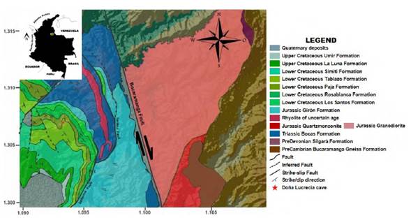
Figure 1 Relief map and geological map of the municipality of Rionegro (adapted and modified after Ward et al., 1973).
The MMVB is an intra cordilleran basin tilted towards the east, with homoclinal tendency, disturbed by some folds and faults (Pérez and Valencia, 1977). The stratigraphic sequence that commonly describes the VMM basin is made up of the Los Santos, Rosa Blanca, Paja, Tablazo, Simití, El Salto, La Luna and Umir Cretaceous Formations. The “Doña Lucrecia” cave was developed in the Rosa Blanca Formation. According to Morales (1958), it is a fossiliferous unit (predominantly mollusks in diverse fragmentation states), very cemented, hence its appreciable hardness, with minor intercalations of marls, calcareous shales, and a tendency to decrease the content and size of macro-fossils towards the ceiling. The Rosa Blanca formation. According to Etayo-Serna and Guzmán-Ospitia (2020) it is composed of 5 members: 1. Lagunetas member, of Berrasian age (composed of dolomitic limestones and fossiliferous micrites), 2. Carrizal member, of Lower Valanginian age (composed of wackstone alternated with mudstone), 3. Zo member, of Lower Hauterivian age (composed of packstone and wackstone), 4. El Sapo member, of Lower Hauterivian age (composed of wackstone alternating with terrigenocalcareous mudstones) and 5. Zapatoca member of Lower Hauterivian age (composed of wackstone and packstone alternating with muddy sandstones). The thickness reported in the type locality is 450 m, which decreases significantly in the E and W edges of the northern sector of the MMVB (Clavijo, 1996). The area of interest is in an active tectonically area, with the NW-trending Bucaramanga-Santa Marta fault system as the main structure influencing the zone, along with the Cachira River Fault with a dextral strike slip kinematics. It is located northwest of this karstic area, from it, the Sardina Fault and other inferred structures are detached. The Sardina Fault is located to the east of the area, shows a vertical inverse movement and is closely parallel to the eastern limit of a rhyolitic intrusion affecting the Bocas Formation (Ward et al., 1973).
Materials and methods
Fieldwork was developed between January and June 2018. Firstly, this included mapping and documentation of the “Doña Lucrecia” cave. Information gathering was carried out on the cave’s dimensions, finding known entrances, geology, and geomorphology of the area, which was accompanied by taking of photographs of speleothems and tectonic evidence. Several samples from strategic points (fallen speleothems in active rooms with low sedimentation and rock samples from the inlets) were collected. They were already broken when collected, although it is unknown when or how this happened. Speleothem samples were axially and transversally cut to describe their structural features. Polished sections were used to study the mineral composition and structure of the speleothem laminae by stereomicroscopy. Subsequently, the stalagmite architectural analysis (SAA) was carried out according to Martín-Chivelet et al. (2017) as a holistic approach inspired in well-established stratigraphic procedures such as the architectural element analysis and the sequence stratigraphy, that are commonly used by geoscientists for categorizing internal stratigraphic heterogeneities in sedimentary deposits. The internal stratigraphy of a stalagmite consists of sets of single growth layers that are defined by their microstratigraphic stacking patterns, which can be progradational, aggradational and retracted (Martín-Chivelet et al., 2013). These patterns are defined by the geometric disposition of growth layers and are mainly controlled by drip rate and chemistry water parameters (e.g., Coleborn et al., 2016; Muñoz-García et al., 2016; Martín-Chivelet et al., 2017).
The interpretation of these patterns is since under similar hydrochemical conditions, the patterns would manifest themselves in the following way: aggradational (constant drip rates), progradational (increasing drip rates) and retracted (decreasing drip rates) (e.g., Muñoz-García et al., 2016). In order to characterize the strata stacking patterns in a longitudinal section of a stalagmite, Muñoz-García et al. (2016) adopted a simple and descriptive criterion based on the diameter of the apex of each growth layer, which is defined as the upper surface directly located under the drop. The polished thin sections help to identify textural and microstructural features of the speleothems by microscopy. A petrographic analysis was carried out by transmitted light microscopy, using a Nikon brand trinocular equipment, model Labophot2-POL. Besides, the textural and morphological features were analyzed by scanning electron microscopy using a FEI QUANTA 650 FEG-ESEM, under the following analytical conditions: magnification = 100-20000x, WD = 9.0-11.0 mm, HV = 20 kV, signal = BSE in ZCONT mode, detector = BSED, EDS Detector EDAX APOLO X with resolution of 126.1 eV (in. Mn Kα). All the samples were carbon coated for observation. Cathodoluminescence (CL) analysis was performed on a thin section of the wall sample to evaluate its color patterns and CL intensity on a transmitted light microscope model LEICA DM 2500 P, with camera coupled model LEICA DFC 450; the CL system is of the CL type CITL MK5- 2. The analytical conditions were vacuum at 0.003 mbar, electron beam defocused at 250 mA and voltage of 15 kV. An spectral analysis was performed in JEOL JXA 8800M electron probe microanalyzer. A Renishaw inVia micro-Raman system was used under the following analytical conditions: laser 532 nm edge (power 0.5%), grating 2400 l/mm (vis), detector Renishaw Centrus 0281Q1, objective x50, continuous scan, exposure time 30s, accumulations 1, focus mode regular, and spectral range 102.52 to 2003.14 (centre -1111) Raman shift/cm- 1. The structural data were processed with the aid of the Stereo 32 program; rosette diagrams were made to do a structural analysis of the geoforms, faults and fractures. The geomorphological map was made with the ARCGIS program.
Results
The “Doña Lucrecia” cave is located at an elevation of 710 meters above sea level, in an area with a humid subtropical climate. According to statistical data from the IDEAM Climatological Atlas (2022), the región receives an annual rainfall between 1,000 and 1,500 mm, with an average relative humidity between 80 and 85%. The temperature in the area varies between 24°C to 28°C, making it a warm and humid environment. The cave’s location within this climatic zone likely has a significant impact on the conditions and characteristics of the cave.
However, it is worth noting that the density of hydrological stations in the municipality of Rionegro, where the cave is located, is relatively low. Therefore, the available data on precipitation and other hydrological factors may not be fully representative of the area surrounding the cave. Additionally, the hydrological network in the area is primarily composed of rivers that drain towards the Lebrija River, including the Cáchira, Salamanca, and Negro rivers. The presence of these rivers could potentially contribute to the formation and maintenance of the cave, as underground water systems are often influenced by surface water flows.
Karst geomorphology
Exokarst: Figure 2A illustrates a typical exokarst morphology associated to the “Doña Lucrecia ‘’ cave, with karren as the main superficial karstic forms, which reveals the occurrence of surface dissolution processes. An example of lapiaz is illustrated in Figure 2B, it can be controlled by lithological and structural, topographic, pedological, meteorological or biological factors (e.g., Soriano, 1985; Gilli, 2011). The forms of karren observed in the study area correspond to rinnenkarren, trittkarren and rillenkarren, which are formed mainly by continuous flow of water. The rinnenkarren are channels of a few centimeters of width and depth, but nevertheless can develop several meters in length, Tributary channels were observed; additionally, there are two forms in their channels, and seen in transverse section there are channels in “V” form and in “U” form, denominated Type A and Type B respectively (Figure 2C). The trittkarren are stepped forms with a vertical surface of 1 to 2 cm and horizontal one, which can later evolve into rinnenkarren (Figure 2D). Finally, the rillenkarren consist of small grooves with a few centimeters (cm) wide and deep (1-2 cm) that can reach tens of centimeters in length (Figure 2E).
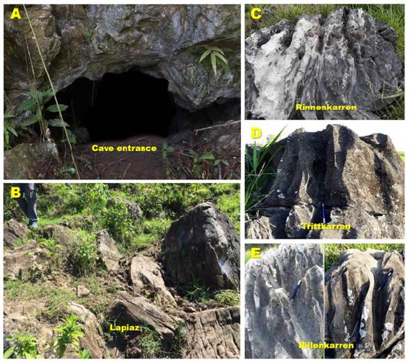
Figure 2 Superficial karstic forms associated with the immediate surroundings of the “Doña Lucrecia” cave.
Endokarst (“Doña Lucrecia” cave): The “Doña Lucrecia” cave forms part of the karstic ecosystems of Santander not yet reported and it is located approximately 19 km NW of the Rionegro municipality, MMVB, that is being hosted in limestones and mudstones of the Cretaceous Rosablanca Formation. The morphological features of the cave are depicted in the geomorphological map of Figure 3. The cave system can be divided into several sectors and is distinguished by the size of its gallery, up to 5 m (2-3 m on average) wide and 10 (3-4 m on average) high, and variety of speleothems (stalagmites, stalactites, columns, eccentrics, etc). It has small corridors connecting eight halls, and the last of them preserve speleothems. It has good ventilation due to the presence of two pits open to the surface. However, there are no facilities to permit access to the cave. The cave is located at about 1000 m.a.s.l. and it does not present notable variations in altitude, which do not exceed 10 m. Each sector is named based on distinctive features, usually derived from outstanding speleothems or some significant event.
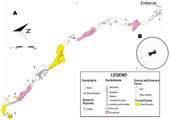
Figure 3 A. “Doña Lucrecia” cave map. B. Rose diagram showing a principally NW-SE trend in the directions of the “Doña Lucrecia” cave´s passages.
The route of this cave begins with an entrance of approximate 1 m high and 1.5 m wide that follows a course towards the W. The 1st room (main hall) with SE-NW orientation is about 22 m long, 2-4 m high and 2.5 m wide (on average), where a large number of stalactites and stalagmites some of them in process of fossilization, teeth of saw, castings and some fallen blocks occur. The 2nd room (radial shape) with EW orientation and connected by a SN gallery, is 6 m high (on average) and 3 m radius, with a lot of castings, curtains, and guano. Crossing this gallery, it is found the 3rd room with SN orientation, which is about 30 m long and 8 m high (on average), where fallen blocks, curtains, moon milk and a chasm occur. Other gallery with SE-NW orientation and 6 m long, 2 m wide and 4 m high that ends with a gap of 1.5 m in diameter to enter the 4th room with SE-NW orientation, which is 16 m long, 4 m wide and 3 m high (on average), where a lot of castings, blocks and stalagmites occur. Then, it is found the access to a gallery with SE-NW orientation, which is 10 m long, 3 m wide, and 2 m high, the 5th room has a EW orientation, which is 15 m long, 5 m high and 6.5 m wide (on average), in which flood deposits, many fallen blocks and few speleothems are observed. Afterwards, the 6th room is found, which has SE-NW orientation and is 12 m long, 7 m wide and 2 m high (on average), with columns, guano, fallen blocks and a depression to enter a gallery of about 6 m that will lead to the next room. The 7th room with SE-NW orientation is about 20 m long, 5 m wide (on average) and 3 m high (on average), occurring castings, moon milk, fallen blocks, helicitites and antodites. At the end of this room, there is a deviation towards the NE that is about 5 m long and is composed of detrital deposits. Leaving this room, a gallery about 10 m long, 2 m wide and 2 m high is found, which is characterized by the presence of numerous fallen trees and the development of some small speleothems. The 8th room found has E-W orientation and is 6.5 m long and 3 m wide, with a large amount of flood deposits. Finally, going up, a small gallery of 4 m long and 1.5 m wide, the last room (9th room) has a radial shape and is 8 m high and 2.5 m radius, where flood deposits such as columns, stalactites, stalagmites, and some fallen blocks occur. The main features of the “Doña Lucrecia” cave are depicted in Table 1
Table 1 Outstanding features of the “Doña Lucrecia” cave.
| Name | Outstanding features |
|---|---|
| 1. Entry | The entrance of the cave |
| 2. The forest | The first room with green and purple colors and little frogs |
| 3. The Vents | Two pits open to surface contribute to the good ventilation of the cav |
| 4. The Bats | Big number of bats living here, abundant guano and fallen blocks |
| 5. The Eccentric | The best speleothem of this cave is here |
| 6. Displaced Passage | Evidence of neotectonic |
| 7. Tinajo’s tunnel | Little tunnel very narrow with footprints of tinajos |
| 8. Stalagmites | Is the last room of the travel with long stalagmites |
Speleothems
Zenithal forms: The most common and familiar of all speleothems are the stalactites (Figure 4A). Frequently, stalactites finish their growth process due to lack of “hydric nutrition” because of the path of percolation moving towards other easier areas of the fissure, developing stalactite curtains (Figure 4B), which can be flags (Figure 4C) forming a box work as a secondary form of flow. All these forms have been called ortho geotropes, because of their growth in the sense of gravity (Llopis, 1970). As a consequence of its emigration along the fissure, stalactite curtains can be also considered as parietal forms (Figures 4D). A cham (Figure 4E) of 1.3 meter in diameter communicating the cave with the outside, which was originated by a karstic erosive process in the calcareous rock or collapse of the ceiling of a cavity through which the water percolates to lower levels. It is usually the degeneration of a sinkhole.
There are also plagio-geotropic speleothems, that is, oriented transversally in relation to gravity. These forms have been called eccentrics (Figures 4F-4G), such as antidotes and helictites, for not having a vertical axis like the other stalactites. In the ceiling there are cupolas (Figure 4H) that are concentric “hollows” of yellowish-brown color with diameters that do not exceed 30 centimeters and where bat groups settle, which can be the result of the action of urine of bats (Dandurand et al., 2019). However, there are many other possible origins, such as condensation, water erosion with the cave filled with sediment, hypogenesis, etc.
Parietal forms: These forms are developed in the walls of the cave by different physical and chemical processes. The wash or casting is a laminar flow over a certain surface which facilitates the loss of carbon dioxide (Figures 4G-4L). The forms can sometimes reach thicknesses of tens of meters, reaching to fill large galleries. Moon milk mainly occurs over the surfaces of some stalactites and flowstones. According to Self and Hill (2003), it is a microcrystalline to nanocrystalline coagulation of disordered acicular individuals, porous and plastic in nature, and containing 40-80% water by weight. Blisters are rounded deposits filled with calcite or gas and it is formed in walls from solutions under capillary pressure (Figure 4I).
Paved forms: The most known and attractive for scientists are the stalagmites (Figures 4M-4Ñ), because of its shape (negative ortho geotrope) and position of deposits, are the materials that most resemble the clastic sediments, so that the stalagmite crust may have the same chronological value.
Mineralogy and petrography of speleothems
Stalactites: The stalactites in this cavity are conical or cylindrical growths from cave ceilings and they are made up of concentric layers of crystals elongated perpendicular to an axis (Figure 5) running from the cave ceiling to floor. Therefore, the petrographic description is made from the center towards the flanks, where it is observed different levels that vary in their mineral composition and thickness (Figure 5A), with layers oscillating between: 1) level of large calcite crystals with characteristic rhombohedral equant texture; 2) level of aragonite with crystals of different sizes developing needle habit (Figure 5B); 3) level of elongated calcite crystals (Figure 5B); 4) level of a boundary between siderite and magnesite with presence a sectored dissolution (Figure 5A). The last two levels are interleaved, maintaining equal thicknesses and similar characteristics.
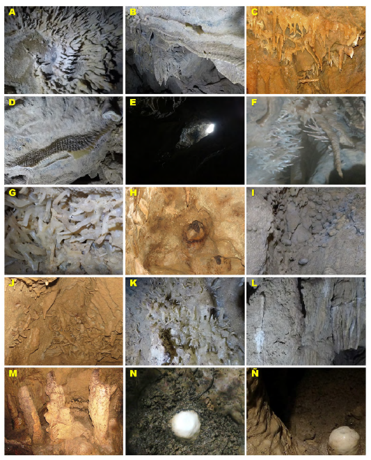
Figure 4 Speleothems of the “Doña Lucrecia” Cave. A. Stalactites. B. Curtains following a fissure from the ceiling to the wall. C. Flags. D. Parietal curtains. E. Cham. F. and G. Eccentrics. H. Cupola generated by bats. I. Blisters and stalactites variety “turnip” in the upper part. J. Eccentric grouping in the wall of the cavity. K. Eccentric grouping in parietal forms. L. Incipient appearance of moon milk in the wall of the cave. M. Long stalagmites. N. Stalagmite “variety fried eggs”. Ñ. Stalagmites in formation.
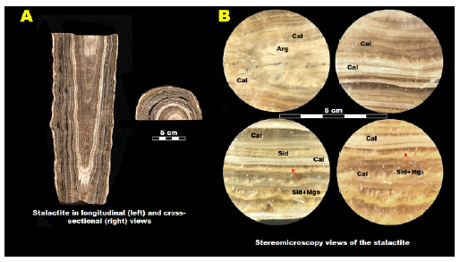
Figure 5 A. Polished surface photograph of the stalactite in longitudinal (left) and cross-sectional (right) views. B. Stereomicroscopy views of the polished surface of the stalactite; note the layers of the stalactite with its limits and changes in the mineralogy. Arg, aragonite; Cal, calcite; Sid, siderite; Mgs, magnesite.
As mentioned before, this type of speleothem is made up of concentric layers of crystals elongated perpendicular to an axis. Nevertheless, near axis the direction of crystals grown is subparallel like aragonite level, with the level of elongate calcite is developing columnar aggregates and presence of fluid inclusions whilst in the boundary of siderite and magnesite level presents dissolution with sectored filling as shown in the Figure 6. This is an elongated stalactite, this means that the saturation of the Ca+ anion was high on the water when the minerals formed; the change of the crystals composition is the consequence of the different precipitation events, some of them rich in elements as Fe and Mg.
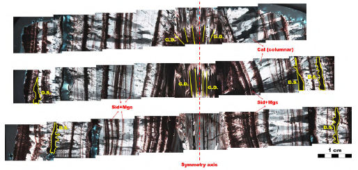
Figure 6 Cross section of stalactite, showing interleaved calcite, siderite+magnesite (dissolution structure in these limits) and aragonite (growth direction subparallel to the symmetry axis). Equant calcite in the core presents a symmetry axis perpendicular to the cave ceiling.
Elongated calcite crystals, with a texture that varies from braided to columnar (Figure 7) and siderite-magnesite level develop elliptical aggregates (Figures 7A-7B). On account of the occurrence of carbonates like siderite and magnesite, calcite (Figures 7A-7B), some dissolution structures are fulling alumina-silicate and oxides fluids containing Si, Al, Fe, K, Mg, affected by different diagenetic processes such as recrystallization and dissolution (Figures 7A, 7C). The aragonite recrystallized into rhombohedral crystal of calcite and towards crystal edges demonstrates the recrystallization by the aragonite relic within calcite crystal (Figure 7D). The differences in the morphology of carbonate crystals are the result of changes in the growth mechanisms under specific atmospheric conditions in the past. According to Frisia et al. (2000), columnar and fibrous crystals grow when speleothems are continuously wet, and from fluids at close equilibrium conditions (low supersaturation), through a screw dislocation mechanism, whereas the highly defective microcrystalline carbonates form at the same supersaturation range but under variable discharge and the presence of growth inhibitors. However, temperature and drip rate monitoring is necessary to explore what controls the temperature of speleothem forming drip water.
Stalagmites: These speleothems grow upwards from the cave floor with a cylindrical to conical growth pattern (Fairchild et al., 2007) (Figure 8A), and the description was carried out from top to bottom where the lower layers are the oldest as established by the principle of superposition. Figure 8B illustrates stereomicroscopy views of the polished surface of the analyzed stalagmite. Calcite is the main mineral that makes up this speleothem, throughout the cross section exists variations: towards the flanks, elongated crystals of calcite and in the core, calcite is minor size, these changes are due to decreases of the dripping erosive force; Type E surface indicates periods of higher drip and Type L surface indicates periods of lower drip, these surfaces indicate variations in local precipitation (Railsback et al., 2013).
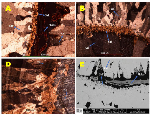
Figure 7 Photomicrographs of the stalactite: A. two more recent levels; B. last three levels showing the dissolution and filling of oxides; C. last three levels without presence of dissolution; D. SEM image showing the dissolution and its respective filling. Arg, aragonite; Cal, calcite; Sid, siderite.
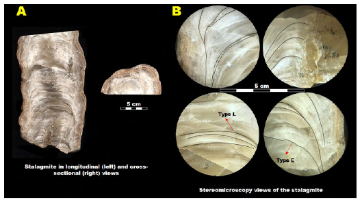
Figure 8 A. Polished surface photograph of the stalagmite in longitudinal (left) and cross-sectional (right) views; B. Stereomicroscopy views of the polished surface of the stalagmite; note the layer-bounding surfaces in stalagmite.
Figure 9 also shows the typical microcrystalline fabric, indicating variations in the crystal size and texture of the calcite, and the corresponding EDS spectra. Towards the flanks, crystals elongate have a braided texture indicating high efficiency of CaCO3 precipitation (Fairchild et al., 2007), whilst in the core occur the microcrystalline texture denoting decreasing on CaCO3 precipitation. This microcrystalline variety reflects rhombohedral exfoliation (Figure 9) where some fluid inclusions are observed. The presence in the core of some very small crystals of zircon indicates that the stalagmite is not only generated chemically but also argues for a detrital terrigenous origin, which creates floods somewhere in the cave
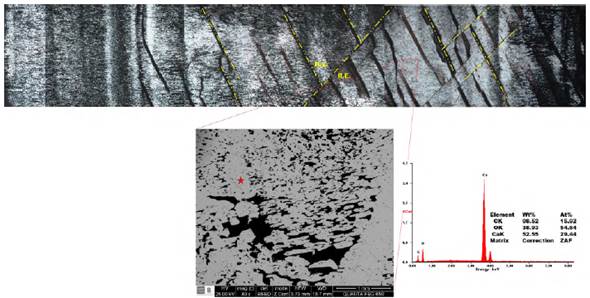
Figure 9 Above, cross section of the stalagmite, showing a rhombohedral exfoliation (R.E.) reflected in the crystal jointing patterns on the microcrystalline fabric. Below, BSE image of the microcrystalline texture and EDS spectrum of the calcite.
Flowstones: Flowstones are laminated deposits which form on cave floors or walls, from thin sheets of flowing water film that is slightly supersaturated with respect to calcium carbonate (Figure 10) (Frisia and Borsato, 2010). An advantage for a paleoenvironmental study is that flowstones can be cored with relatively little damage to the cave environment, and they can grow over tens of thousands of years (Fairchild et al., 2007). Flowstones in this cavity appear in different interleaved types of carbonates like calcite (CaCO3) and siderite+magnesite (Mg, FeCO3) (Figure 10).
The greater presence of siderite+magnesite (Mg, FeCO3) (Figure 11) indicates a large contribution of Mg-Fe during its growth and could be related to the layers found in the stalactite, a different event or record of various events with annual climate cycles. These layers share a tendency to display undulations in surface morphology and the lamina structure is dominantly parallel and continuous, but in detail there are many subtypes like this case (Figure 11) not has an axis of symmetry due to the variation on thickness and quantity of layers, reflecting local slopes, water supply and other factors (Hill and Forti, 1997).
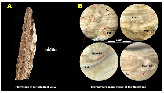
Figure 10 A. Polished surface photograph of the flowstone in longitudinal view. B. Stereomicroscopy views of the polished surface of the flowstone; note the changes in the continuity and quantity of the layers on flowstone, in the type of precipitate carbonate, crystal size and fabric. Cal, calcite; Mgs, magnesite; Sid, siderite.
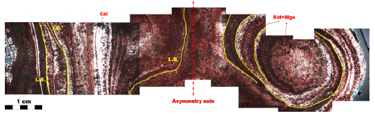
Figure 11 Cross section of the flowstone, variations on the thickness and parallelism of the layer boundaries (L.B.) due to the asymmetry with the axis perpendicular ceiling.
Primary columnar calcite has been observed in different phases of the stalactite (Figures 6, 7A-7B) and towards the flanks of the stalagmite. The stratigraphic position varies depending on the drip conditions and the type of speleothem. For the case of the stalactite, the columnar calcite appears at different levels identifying two types of fabrics that are columnar and braided (Figure 7). These fabrics are interspersed at the outermost-old levels, the columnar fabric is characterized by elongated crystals parallel to subparallel in the direction of the growth of approximately 300 to 450 μm in length and between 50 to 60 μm wide. Braided calcite appears in the stalactite in the last level of this, which differs from the previous fabric because the parallelism is slightly lost in the edges of the crystals and its size decreases varying between 100-160 μm in length and 20-30 μm wide, this fabric is also identified in the stalagmite towards the flanks (Figure 8). Primary acicular aragonite shows a fibrous texture (Figure 5) in the direction of sub parallel growth to the cave ceiling (Figure 6). It appears in one of the most recent levels of the stalactite (Figure 6) with a thickness of approximately 3000 μm, limiting with the rhombohedral crystal calcite core, the aragonite crystals are approximately 130 μm long. Sparite cement is composed of equants crystals of sizes approximately of 40 μm, they are developed in the boundaries of the calcite and aragonite levels in the stalactite (Figure 5B); whereas micrite is very smaller size than the previous one with a microcrystalline texture, which predominates towards the center and all the vertical axis of this one in the stalagmite (Figure 9B). Isolated rhombohedral crystals can be identified in the central level of the stalactite, which represent the most recent crystal growth with an equant texture and with the twinning characteristic of the carbonates, being a single crystal of an approximate size 2000 μm (Figure 7C). Siderite represents the oldest stratigraphic levels and an approximate thickness of 340 μm in the stalactite (Figures 5-6) and in the flowstone appears on different layers (Figures 10-11), developing concentric and elliptical aggregates mostly, with an approximate diameter of 30 μm (Figures 8A-8B). At the level where this carbonate variety occurs, there are dissolution structures (D.S.) towards the most recent limit (Figures 5-6), where in some dissolved places there is a filling with aluminosilicate and ferrous fluids (Figures 7A-7D). Magnesite occurs along with siderite in the stalactite and flowstone with similar properties (Figures 5-10), due to enrichment of rate Mg/Fe (Figure 11) and a decrease in siderite precipitation. Zircon is observed in some layers of the stalagmite with very small sizes that were noticed and verified through the microscopy techniques.
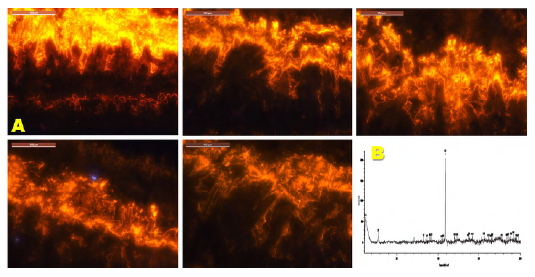
Most carbonate petrologists consider Mn2+ and Fe2+ to be the only trace elements responsible for cathodoluminescence in carbonates. Figure 12 illustrates an example of the cathodoluminescence microscopy and micro-Raman spectroscopy of the flowstone. Checking the oscillatory zones of calcite (generally brown colored). In contrast, the samples of stalactite and stalagmite did not show cathodoluminescence, which can reveal a secondary calcite origin. From the premise of finding fluid inclusions in the crystals of the mineral present in the wall sample and due to their fibrous nature, it is observed that the fluid inclusions do not show a sufficient development for the measurement of the gasses contained in them. However, measurements were made on several crystals contained in the sample; different possible matches of the resulting micro-Raman spectrum with the comparison of the database are observed with different colors. With more rigorous fluid inclusions for a pre-feasibility study, it is possible to identify measurable fluid inclusions, in order to generate a doubly polished section and to make a more complete microthermometric investigation along with micro-Raman.
Speleothem microstratigraphy
Martín-Chivelet et al. (2017) introduced the Speleothem Architectural Analysis (SAA) to establish the growth conditions of speleothems (stalagmites), to genetically interpret stalagmites on a multi-temporal scale. The detailed stratigraphic analysis of speleothems constitutes a fundamental base in the reconstruction of the paleoclimatic conditions of the Quaternary history (e.g., Gázquez and Calaforra, 2016; Martín-Chivelet et al., 2017; Jones et al., 2018).
The stalagmite of interest in this study shows growth axis based on the general shape and geometry, despite not having isotopic evidence to establish the age and duration of growth of the speleothem (stalagmite) or to determine if the changes observed in its texture are associated with hiatus. Figure 13 shows that, according to the micro stratigraphic stacking patterns (fourth order elements) proposed by Muñoz-García et al. (2016), the analyzed stalagmite may be progradational, aggradational, and retracted. Macroscopic analysis of the longitudinal polished section of the examined stalagmite (Figure 13) reveals discrete growth layers, with the growth axis showing slight changes in direction, in some cases, the axial laminae flatten to define “stalagmite top” morphologies like those described by Rowe et al. (2020), who considered that there is no evidence that growth stopped at any of these morphological surfaces. The core of the speleothem, which is constituted by pale creamy carbonate layers, is flanked by a prominent band of brown carbonate layers. However, we do not have clear evidence on the occurrence of corrosion surfaces, which can be interpreted as a hiatus. The areal limits of the upper surface are marked by a line that defines a slope break and the change into the flanks of the stalagmite. Therefore, the diameter of the apex represents the distance between the two opposite breakpoints observables in the stalagmite polished section. Stalagmites are not perfectly cylindrical, this approach should be adopted with caution, assuming the inherent limitations of 2D microstratigraphy (Martín-Chivelet et al., 2017). These diameters, horizontally measured, constitute the micro stratigraphic stacking patterns log (Muñoz-García et al., 2016). Both the fabrics and the micro stratigraphic stacking pattern of growth layers, stalagmite, from the “Doña Lucrecia” cave provide valuable information about the drip behavior and can be used as a paleoenvironmental indicator, which is very useful when not petrographical sections are available.
Speleothems constitute geological archives of great importance as they can provide valuable information on chronology, stratigraphy, growth rate, geographical distribution, or paleoclimatology (e.g., McDermott, 2004; Wong and Breecker, 2015). According to the microstratigraphic stacking patterns observed in the analyzed stalagmite, we concluded that growth rate could have varied significantly over time. However, a lack of knowledge of the relationships between crystal texture and growth rates does not allow a better interpretation. There were no clear hiatus events present in the stalagmite studied.

Figure 13 Fourth order architectural elements: Method for differentiating successive stacking patterns sets within a longitudinal polished section of a stalagmite, as proposed by Muñoz-García et al. (2016). To obtain quantitative logs, the distance between the “breakpoints” of each growth layer can be measured along the stalagmite. Variations in this distance through the growth axis allows us to define trends ; thus, retracted, progradational or aggradational sets.
This speleothem grew in successive layers perpendicular to its longitudinal axis and its growth rate was undoubtedly controlled by the drip rate and the concentration of CaCO3 in the water. However, several parameters, such as water supply rates, chemical kinetics and flow conditions on the Surface of the speleothem probably controlled the growth of speleothems, which may reveal palaeoclimatic signals inscribed into the morphology and stratigraphy of the analyzed stalagmite. Besides, its relationship with climatic oscillations makes a very useful archive to carry out palaeoenvironmental reconstructions. The presence of minerals of detrital origin such as zircon in the stalagmite may be associated with ancient flooding of the cave due to periods of intense rains in which the infiltrated water could cause the underground river to flood the cavity where the stalagmite was forming. However, it must be supported by isotopic studies to contribute to the knowledge of the absolute ages of such speleothem and the paleotemperatures of formation of growth rings or bands.
Karst hydrogeology
The karst hydrogeology characteristics of the “Doña Lucrecia” cave reveal that it is an active one because it has a constant flow of water inside, the speleothems mostly dripping. Hydrodynamically, and under these criteria, the cavity can be considered hydro geologically active. A general knowledge of this karstic cavity is summarized below. Branching networks of conduits has been developed along fractures and bedding throughout the limestones of the Lower Cretaceous Rosablanca Formation, developing secondary porosity and creating suitable pathways for the circulation of fluids in the downstream direction, which constitutes one of the most important karst characteristics of interest in this study. Limestones have a specific hydrogeological behavior because of several factors that control karstification; although the tectonic activity is the one of the major factors that played a very important role in the development of the karst in this region.
There is no doubt that the fractures played a major role in the initiation and enhancement of the karstification process, yet it depends on the density and occurrence of fractures. Several flow zones were probably developed along such plans of weakness and the enlarged openings in the limestones generated a groundwater flow, which produced further dissolution of these rocks, although without evidence of the formation of sinks and springs. This can be explained if we consider that horizontal cave systems tend to form at the intersection of vertical fractures and horizontal seams between depositional layers. The formation of the “Doña Lucrecia” cave is likely a complex process
that involves multiple factors. One key factor is the flow of water through the surrounding rock. As water percolates through the rock above the cave, it likely carries dissolved minerals and other materials with it. When the water reaches the cave, it may deposit these materials in layers, creating the distinctive formations that we see nowadays. However, the process is not necessarily straightforward, depending on the location of the cave and the geology of the surrounding area, the flow of water may be intermittent or irregular. This could result in different parts of the cave forming at different times and under different conditions. For instance, some parts of the cave may have formed when the water table was higher, while others may have formed during drier periods when the water table was lower. In addition, it is worth noting that the formation of caves is a slow process that can take thousands or even millions of years. As a result, the cave may have formed over a long period of time, with different layers forming at different stages of the process.
Overall, while we can make some knowledgeable guesses about the process that led to the formation of the “Doña Lucrecia” cave, it’s important to remember that there is still much we do not know. Further research and exploration may be necessary to fully understand how this unique geological feature came to be. This cave shows evidence of hydric activity with horizontal and vertical water flows, such as underground ravines or drip of speleothems, which changed significantly over geologic time, as part of the complex hydrological and hydrochemical behavior of water percolating through the karstic system. The recharge area is represented by the entrance and very small chasms of cavities that present mainly vertical and intermittent flow of water, which depends mainly on atmospheric conditions and water only filters when there is rain. As shown in Figure 3, the location of the stagnant water bodies in the two wells.
The lack of underground flows such as streams or waterfalls suggests that the cave is not actively being fed by a consistent source of flowing water. Instead, the presence of small bodies of stagnant water in the wells implies that the cave may be affected by changes in the piezometric level, which could be caused by fluctuations in the water table elevation. This interpretation is supported by the fact that the Wells are located at the lowest points in the cave system; therefore, it may represent the current water table level. These observations are important in understanding the hydrology and geomorphology of the cave, as well as the potential implications for the cave ecosystem and management strategies. It would be beneficial to conduct further studies to monitor the water levels in the wells and to explore any potential connections between the piezometric level and the cave’s geological features. Another explanation to this can be related to rainwater that was deposited on a waterproof layer. The water has definitively left the cavity, which begins to undergo fossilization due to lithogenesis. Figure 14 shows a sketch of the “Doña Lucrecia” cave.
Speleothems as an indicator of neotectonic and paleoseismic activity
The analysis of the orientation of the passages of the caves represents an original and useful approach for the study of neotectonics (Littva et al., 2015). Detailed observations of recent seismic activity are required to determine whether broken or deformed speleothems can be used as effective proxies for paleoseismic activity (Zhao et al., 2020).
The structural analysis in the “Doña Lucrecia” cave consisted of comparing the trends of the orientations of the passages with the youngest regional stress tensor, defined by works carried out in the Middle Magdalena Valley basin, relatively close to the area of study. The passages of this cavity present two main patterns of orientations ranging from N-S to NW-SE (Figure 3B), which coincide with the direction of the minor faults that come off the Cachira River Fault, generally the orientation of cave passages is perpendicular to the orientation of the tensor of greater extension, the direction of extensional component of the stress field has been assumed to be perpendicular to the orientation of cave passages (Littva et al., 2015). Local structures are part of a complex orogeny of the Andean region (Oligocene) (e.g., Lozano and Zamora, 2014).
Bearing in mind that in the regional stress tensor, the greater compression (σ1) has approximately NW-SE tendency and the lower compression (σ3) NE- SW, it is deduced that the preferred directions of the passages are perpendicular to σ3 and parallel to σ1, which suggests that the “Doña Lucrecia” cave was formed under the action of this regime of stress. The cave has different periods of the karstic cycle with the predominance of maturity, the last room are in senility period and have embrionary conducts in NE sense (Llopis, 1970). In “Doña Lucrecia” cave, fallen blocks, including collapsed stalactites that had fallen from the ceiling, fractures in speleothems (stalactites, stalagmites, and flowstones), are well preserved due to the lack of tourists, and on the cave ceilings, new broken stalactites mixed with old broken stalactites, and the presence of a corridor showing displacement, represent evidence of active tectonics in the area in recent years.
Discussion
During karst evolution, the “Doña Lucrecia” cave was probably controlled not only by the initial structural settings of the rock, but also by the emergence of fractures and the fluid flow conditions particularly within low porosity rocks, such as limestones of the Lower Cretaceous Rosablanca Formation. Unfortunately, the climatic information of the studied area is not extensive despite the existence of a network of meteorological stations in its surroundings. However, some relevant aspects of the climate of the study region are presented below.
For hundreds of thousands of years, the drops of rainwater that fall on the surface are beginning to open up, mainly along fractures to reach the karst system. This is generating different types of speleothems within those that stand out the stalactites and stalagmites, the latter is of great importance in paleoclimatic studies since they preserve an imperative isotopic record to reconstruct the recent paleoclimatic history since they constitute a valuable archive on how the rain patterns have changed during the quaternary (e.g., Edwards et al., 1987; Li et al., 1989; Muñoz-García et al., 2008; Denniston and Luetscher, 2017). The rate of annual vertical growth of stalagmites is recorded in changes of calcite fabric, fluxes of fluorescent organic matter or annual variations in trace element composition (e.g., Mariethoz et al., 2012). According to Duan et al. (2012), stalagmite laminae can be related to 1) fluorescent laminae due to annual variations in organic matter flux (e.g., Borsato et al., 2007; Hartland et al., 2014), 2) petrographic laminae as a result of annual variations in calcite texture (e.g., Polyak and Asmerom, 2001; Martín-Chivelet et al., 2017), 3) calcite-aragonite couplets (e.g., Denniston et al., 2000), 4) traceelement laminae (e.g., Fairchild and Treble, 2009), and 5) aragonite laminae developed by the alternation of thin brown and thicker clear aragonite sub-layers (e.g., Yadava et al., 2004; Duan et al., 2010). Similar to what occurs in other underground systems, the factors that control the growth rate of stalagmites in the “Doña Lucrecia” cave are plenty and complex, including pH value and the drip rate, which in turn are controlled mainly by cave-air CO2 concentration and local rainfall, respectively. However, the factor that most influences the growth rate is Ca2+ concentration that can be controlled by local atmospheric temperature and rainfall (Duan et al., 2012). The limestones of the Rosa Blanca Formation are soluble rocks with dense net of fractures, which have been enlarged by dissolution due to the flow of groundwater that promote an interaction fluid-rock and then, karst conduits start to evolve developing a branch network of conduits probably with a dendritic pattern of flow.
Conclusions
The “Doña Lucrecia” cave represents an important element of the geoheritage present in the territory that remains hidden without identifying and valuing. The evidence of karstification in rocks of the Rosa Blanca Formation in the exokarst and endokarst indicate the possibility of finding much more subterranean systems in the zone. The presence of two main patterns of orientations for the passages of the cave that vary from N-S to NW-SE match the direction of the minor faults that come off the Cachira River Fault. Besides the presence of many fallen speleothems, deviation in its growing axis and displaced passages indicate an important role of tectonics in its formation. This cave is still active and the process of karstification is going deep in the embrionary conducts that are closer to the final room. The petrographic analysis of the rocks provides information of the chemical and physical formation condition and their subsequent processes (dissolution, recrystallization, etc). The speleothems are analyzed and provide results on the chemical composition of the drip and underground water, this emergence in the stalactite and flowstone of the siderite-magnesite indicates that this water contained iron and magnesium ions whose enrichment is given by leaching from the host rock or surrounding rocks or by pedogenic processes principally. In the stalagmite, the vertical mineralogical homogenization indicates similar conditions on rate drip, also in the water composition and the presence of levels with detritus high content corresponding to paleofloods inside of the cave. The identification of the architectural elements in speleothems, stalagmites principally, represents a first genetic approach for the compression of the underground conditions of drip rates, drip stability, hydrochemistry, and other environmental factors. Fallen blocks, including collapsed stalactites that had fallen from the ceiling, fractures in speleothem and on the cave ceilings, new broken stalactites mixed with old broken stalactites, and a corridor that shows displacement, represent evidence of neotectonic and paleoseismic activity.

