


 English (pdf)
 Article in xml format
 Article references
 Send this article by e-mail
 Cited by SciELO
  Cited by Google
  Similars in
SciELO
Similars in
SciELO  Similars in Google
 Permalink
Introduction
The karst landscape of the Serra da Bodoquena, in Mato Grosso do Sul/Brazil, has a scenic beauty that reminds us of the idea of a preserved nature. However, the anthropic advance, especially soybean plantations, bring with them a dynamic in the landscape and raise concerns about the instabilities that the karst landscape promotes. The previous experiences helped us understand that the worldwide recognition of Bonito as a tourist destination goes beyond the translucent rivers, because it is from the characteristics of the karst system that the features in the landscape and the waters gain prominence and become tourist attractions.
Karst is not something particular to Mato Grosso do Sul and Bonito, or to Brazil, karst is a phenomenon spread all over the planet, where the rocky substrate is formed by soluble rocks. The definition of what is soluble rock is fundamental to understanding what the "true karst" is. Soluble minerals, all rocks have, the rocks themselves exhibit some solubility, however, according to Travassos (2019) if rocks exhibit more than 20% insoluble components, typical karst features rarely develop.
Tricart (1956) pioneered karst studies in Brazil, although there was no Brazilian Karst classification then. In the late 1970s, Karmann and Sanchez (1979) established the karst subdivision and description in Brazil and identified five main speleological provinces: Ribeira Valley, Bambui, Serra da Bodoquena, High Paraguay River, and Ibiapaba Range. Later, further progress was made in the description and identification of the provinces, with data from the Brazilian Centre of Caves Research and Conservation (ICMBio, 2009).
The present research focuses on the relevant karst system of Serra da Bodoquena, Mato Grosso do Sul State. The Serra da Bodoquena region shows an array of marble and limestone deposits, few archaeological sites, and numerous caves, dolines, mogotes and other karst features that sign the local landscape. According to Bigarella et al. (1994), and Kohler and Castro (2009), a karst area is defined by carbonate or dolomitic rocks with significant extension and volumeand real thick carbonate rocks near the surface. The carbonated areas may show different periods of topological development, not continuously but in a cycling cycle (Carvalho-Junior et al., 2008). Thus, the karst rock evolution occurs due to the dissolution of calcium carbonate CaCO3 and magnesium carbonate CaMg(CO3)2 that becomes bicarbonate calcium (Ca(HO3)2) by hydrolysis reaction. The study of the chemical dissolution process at the karst rocks is essential, according to Piló (2000, p. 89-90). Karst studies show water as the main agent of karst landscape creation and speleogenesis. Bigarella et al. (1994, p. 255) define the water process as "landscape karstification", with mature karst features such as poljes, karren, river sinks, resurgences or uvalas. Thus, the research on karst morphostructural units contributes to comprehending some shortly studied areas.
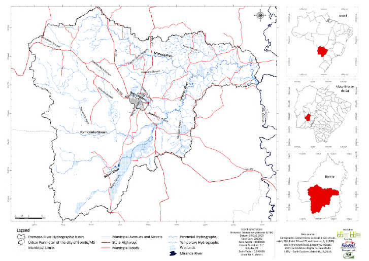
Bonito region, together with Bodoquena and Jardim, is unique for its outstanding environmental beauty and a relevant Brazilian karst region (Lobo and Moretti, 2009). The main aspect of the Bonito landscape is its rivers with clear waters and waterfalls. The local hydric characteristics often undergo deposition and dissolution chemical processes. The main springs of Formoso River Hydrographic Basin are located at Serra da Bodoquena, an area with scientific, environmental, cultural, and geological significance. However, local and regional economic actions (special agribusiness sector) have demanded attention concerning its regional management. The present research aims to identify and analyze the spatialization and main aspects of its morphostructural units (soil diversity, topography, and hydrographic basin land use) and present significant karst landscape information of Serra da Bodoquena. The study area is geographically located in the southwest region of Mato Grosso do Sul State with a total area of 1.324,67 km2. Two main topological references characterize the area, Serra da Bodoquena (west) and Maracaju Mountains (east) (Figure 1).
Methodology
The spatial mapping of morphostructural units was carried out by ArcGis 10® through the geological map interface data collection provided by The Geological Survey of Brazil (Companhia de Pesquisa de Recursos Minerais - CPRM). Nevertheless, the CPRM data access presented distortions, so four topographic charts provided by The Brazilian Geographic Service Directory (Diretoria de Serviço Geográfico do Brasil - DSG) were used to support the studies: 1) Aldeia Lalima - SF.21-X-A-VMI - 2584; 2) Jardim - SF.21-X-C-II; 3) Rio Perdido - SF.21-X-C-IMI-2619; and 4) Vila Campão - SF.21-X-A-IVMI - 2583. The four charts were generated from aerial photos dated 1966 and printed in 1973. All data collected were checked up, and we used Sentinel 2A/ MSI Images from March 15th, 2017, and SRTM digital model terrains offered by The United States Geological Survey - USGS to correct distortions. Notwithstanding, we highlight that the know-how of the study area and in loco observations were required to correct CPRM geological map distortions (with the core objective of checking the local and regional geological outcrops).
Results
The Formoso River Hydrographic basin is partially located above the carbonate rocks of the Corumba Group related to the regional karst systems, where carbonate rocks created some quaternary deposits (Sallun Filho and Karmann, 2007; Sallun Filho et al., 2009). The geological configuration of the study area is defined by two remarkable rocky substrates, the Corumba Group and the Cuiaba Group. The Corumba Group presents carbonate rocks, specially calcitic limestones and dolomites. It presents special topographic characteristics such as karren, dolines, mogotes, caves, abysses, sinks, resurgences, residual hills, and ranges. The Cuiaba Group presents terrigenous rocks as phyllites, sandstones, and shales (Figures 2 and 3). Thus, Bonito landscapes show environmental aspects directly entangled with karst hydrogeological processes. The karst hydrogeological processes created a complex and distinguishable landscape with visible contrasts between high-elevation sectors (ranges and residual hills) and low areas (showing poljes, plain terrains, and smooth hills).
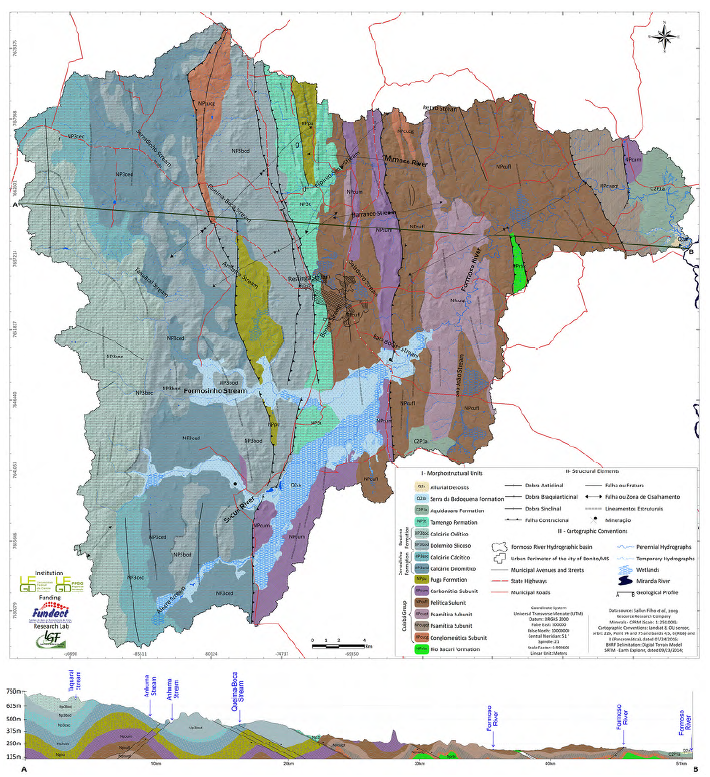
Figure 2 Map of Morphostructural Units of the Formoso River Hydrographic basin, Bonito - Mato Grosso do Sul - Brazil.
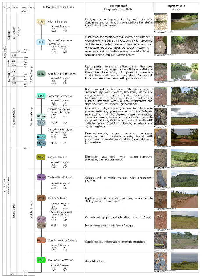
Figure 3 Stratigraphic column of the Formoso River Hydrographic basin Units. Bonito - Mato Grosso do Sul - Brazil.
The Formoso River Hydrographic basin shows significant geological diversity; however, two main geological groups draw attention. Fifteen geological formations dating 850 to 630 million years (Bacuri River Formation - Criogenian Period) occurred, and recent alluvial deposits that do not date more than 10.000 years (Holocene). We define the fifteen formations as units (morphostructural units). The Bacuri River Formation is the oldest morphostructural unit of the study area. Its rocky substrate is formed by metavolcanic sediments with significant graffiti schists (Figure 4). The geological formation was separated from the Cuiaba Group, indicating an oceanic crust-reminiscent aspect (Lacerda Filho et al., 2006). The graffiti schists are visible within smooth terrains near water divisors, mainly in the medium course of the basin. However, to the east of Bonito, graffiti schists appear on the ground along local roads next to the Formoso River. The Bacuri River Formation occupies a small area of 3.77 km2 (0.28% of the total hydrographic basin).
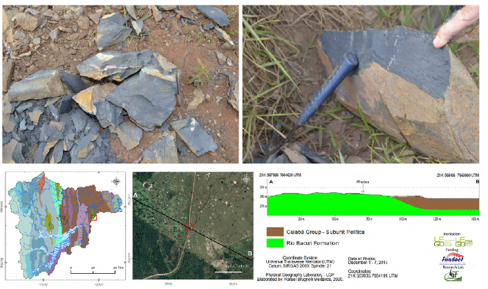
Figure 4 Graffiti schists (Bacuri River Formation) are found on a local road east of the Formoso River Hydrographic basin.
The Cuiaba Group presents rocks with considerable variation within its units. The rocks are located between the central and north sectors of the study area to the east, near the Formoso River mouth. The formation occupies an area of 470.10 km2, and its stratigraphic group is compounded by low metamorphic sediments, specially phyllites with quartzites frequently crossed by quartz deposits. The second morphostructural unit (Conglomeratic sub-unit) is based on pebbles and grains of quartz, quartzites, marbles, granite, and gneiss on a shale and phyllite matrix (Nogueira et al., 1978, apud Lacerda Filho et al., 2006). The unit is located northeast of the hydrographic basin and occupies an area of 20.18 km2 close to a contraction fault of 20.88 kilometres. The same unit was found in the north sector of Bonito municipality, near a linear rock structure. The Conglomeratic sub-unit presents smooth relief of low slopes without a particular pattern. It occupies only 1.77% of the study area and shows a massive presence of pastures and some forests above latosols and Chernozems (or Mollisols). The Psammitic is the third unit of the Cuiaba Group. It is composed mainly of quartzites, then phyllites and shales (Lacerda Filho et al., 2006). The quartzites are yellow-cream, fine to medium textured, and have 90% of quartz with a secondary presence of muscovite, biotite, chlorite, and rare magnetite. The quartzites may gradually change to phyllites, meta-sandstones, and meta-greywacke (sedimentary fine textured rock composed of sand fragments, quartz, clay, or feldspar limestone). The Psammitic unit of the Cuiaba Group was divided according to its general character, as metagreywackes and quartzites (NPcugt) or by the presence of quartzites, phyllites and shales (NPcugqt).
The difference between classes encompasses more than the nomenclature itself. The first geological division (NPcugt) defines plain to smooth terrains with a predominant land use of pastures and forest areas within a complex pedological scope. Highlighting the relief aspect, some residual hills present slopes that reach 45% inclination. The NPcugt area is located north to south of the hydrographic basin with 78.38 km2 of extension (5.91% of the study area). The fourth unit, the Psammitic morphostructural unit, is technically called NPcugqt. The unit presents plane relief, located on the low sector of the hydrographic basin near the Formoso River mouth. The area presents the lowest elevations (200 to 280 meters high), slopes ranging from 0 to 20% of inclination and a 30.99 km2 extension. The Psammitic area shows a long contractional fault of10.56 km west of its border. The Pelitic morphostructural unit (Figure 5) is the fifth unit of the Cuiaba Group. It is the largest and is located among faults and fractures. The unit presents mica schists with green to light grey colours when they are fresh.
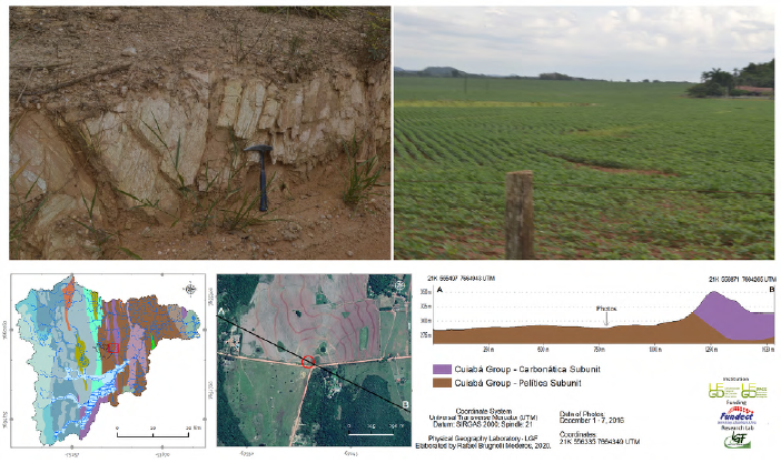
Figure 5 Pelitic unit of the Cuiaba Group at study area represented by the phyllite outcrop near Bonito municipal road.
Nevertheless, they become brown to reddish when exposed to the erosion process. We identified sericite intercalations, as well as quartz and shales. The unit was recognized by its phyllites accompanied by quartzites, shales and metasandstones of the Formoso River Hydrographic basin (terrigenous rocks geographically located on residual hills at medium and low hydrographic basin sector). Pastures and forests predominate land use activities and cover an area of 263.92 km2 (19.91% of the hydrographic basin area).
The sixth unit of the Cuiaba Group is defined as a Carbonated Unit and represented by calcitic marbles and dolomites with phyllites. According to Nogueira et al. (1978 apud Lacerda Filho et al., 2006), calcitic marbles are predominant over dolomitic in the unit. The calcitic marbles present millimetric metamorphic foliation and isoclinal bends. The dolomitic marble shows a massive structure and fractured features. The unit occupies 73 km2, and it is located near regional faults. The largest bulk of carbonate rocks occupies 27.37 km2 and extends along the central area of the study area, delimited by a contractional fault.
Furthermore, it is a type of karst system transition zone according to its soils, local land use, and topography. Thus, it is a transition between karst areas (to the west of the study area) and terrigenous areas (to the east). The karst system that modelled the slopes of the Serra da Bodoquena and the plane and smooth surfaces of its plateau is changed by the terrigenous system near the Miranda River depression, where pastures and some reminiscent forest areas significantly occupy mature and well-drained soils. Almeida (1965), Boggiani (1990) and Alvarenga et al. (2000) describe the Puga Formation (Cryogenian period) as a terrigenous area. Baptista et al. (1984), Rolim and Theodorovicz (2010), Corrêa etal. (1976), and Nogueira et al. (1978, apud Lacerda Filho et al., 2006) classify the formation as a carbonate formation. Some authors exclude the Puga Formation from the Cuiabá Group. Boggiani (1990, p. 1) states that Puga Formation presents its lithology aspects as essentially terrigenous. Alvarenga et al. (2000) highlight that the formation presents diamictites, a conglomeratic rock with large scattered fragments layered into a silty-clay matrix. The geological formation shows paraconglomerates, sandstones, siltites and shales related to the Marinoan Glaciation Period, 670 to 630 million years (Alvarenga and Trompette, 1992). According to the authors, the Puga Formation does not present essential carbonate characteristics to be classified as part of the Corumba Group. There is a complex controversy about the stratigraphy of the metaconglomerates. In this work, we follow the Alvarenga et al. (2009) definition of the Puga Formation, this unit is found in two tiny rock blocks. One block is located north of the river basin showing linear structure, faults or shear zone within a mountainous area with "V" valleys, thus, waterfalls and streams. However, the other block is found in the central area, and delimited by a contractional (inverse or push) fault to its west side, showing linear structures and plain relief to its east side. The two units occupy 32.89 km2 altogether (2.48% of the hydrographic basin area).
The Corumba Group compounded by carbonate rocks, especially calcitic and dolomitic limestones. Boggiani (1990) describes the formation as Cambrian and Vendean or Ediacaran (Vendean or Ediacaran period is a geological period that started 635 million years ago and finished in the Neoproterozoic 540 million years ago). The limestones show high levels of calcium carbonate and magnesium carbonate, thus, less resilient, facing erosion and weathering processes, and causing significant influence on surface waters. In addition, the Corumba Group has fissures that result in cryptogenic drainage systems and subterraneous hydrographic basins. The geological group shows four main units: 1) Cerradinho Formation, 2) Bocaina Formation, 3) Tamengo Formation, and 4) Guaicurus Formation (Almeida, 1965; Gaucher et al., 2003).
Cerradinho Formation is structured by a diverse lithology of elements and a layer of a few hundred-meter thicknesses located at the base of the Corumba Group (Campanha et al., 2011). Detrital sediments of limestone and dolomite characterize it. However, Almeida (1965) shows that the geological formation lay down above granites from the Apa River Complex, showing an erosive discordance. The Apa River rocks show conglomerates, sandstones and "arcoseos", which present sedimentary characteristics, possibly revealing quartz, feldspar, and lithic stratified fragments with asymmetrical wave marks. Limestones and dolomites also compound the intermediated and superior rock sectors. The dolomites present light grey colour and massive layers or shades that change place rhythmically with limestones. Thus, the Cerradinho Formation is a morphostructural unit with carbonate rocks (NP3ced - dolomites; MP3cec -limestones). The rocks are located on the west side of the Serra da Bodoquena, and the area is characterized by its plain terrain, with residual hills and abrupt and long slopes to the north of the Range. The dolomitic unit (NP3ced) occupies 197.84 km2 (14.92% of the hydrographic basin area), showing contractional faults and structural lineaments to the south. The limestone unit (NP3cec) occupies 57.31 km2 and is found in two large bulks at the edge of Serra da Bodoquena (northwest and southwest of the Formoso River basin). Due to its karst aspect, the limestone area does not exhibit considerable drainage, and cryptogenic drainage may also be found. Bocaina Formation shows different aspects compared to Cerradinho Formation. The formation presents harsh topography and higher hypsometry than the other geological formations of the Corumba Group.
Bocaina Formation shows reverse faults and a remarkable sequence of limestones, dolomites, and marbles (Almeida, 1965). Two distinguishable units are characterized within the Bocaina Formation due to their specific lithological aspect and geological age. The older one is formed predominantly by dolomites and classified as NPbod (on the west sector of Bonito municipality). The NPbod unit shows contractional push or reverse faults and a poor drainage system (Baptista et al., 1984).
NPbod unit extends through 229.42 km2 (17.30% of the study area). Thus, in the Bocaina Formation, the land use is predominantly occupied by pastures and temporary cultures due to the type of relief. The relief is characterized by plain or smooth poljes to residual hills up to 45% of inclination. The unit presents thick layers of dolomites located above the granites of the Apa River Geological Complex (Boggiani, 1997). The occurrence of intercalations between dolomites and silexits is associated with carbonate or silicacarbonate rocks influenced by granite located below them (SIGEP, 2001). The NPboc (limestones) of the Bocaina Formation is characterized by mountainous relief with relevant altimetric amplitudes and the predominance of forests with Chernozems (or Mollisols) . The NPboc occupies 150.35 km2. The youngest geological formation of the Corumba Group is Guaicurus Formation (Almeida, 1965), over the limestones of the Tamengo Formation. The formation originated from clastic sediments allied with calcitic limestones. It is defined as the superposition of calcitic limestones above dolomites of the Bocaina Formation with a 100-meter thickness of black limestones mixed with carbonate shales (Almeida, 1965; 1984). The formation is in the central sector of the study basin (west of Bonito municipality) and shows a contractional fault (reversed or push fault) 25.35 km long. It extends from the extreme north of the study area to Serra da Bodoquena Formation, near the Formoso River. The unit covers 58.61 km2 (4.42% of the hydrographic basin area) and shows a classical karst topography with residual hills. The residual hills present "V" valley shapes (especially at the Karst Pavements of the Serra da Bodoquena area), and the locations show classical endokarst and exokarst features represented by dolines, abysses (Figure 6 "1"), grottoes (Figure 6 "2"), river sinks (Figure 6 "a"), uvalas, karren, caves (Figure 6 "b"), stalagmites, stalactites (Figure 6 "c"), subterranean lakes (Figure 6 "d"), subterranean water flows (Figure 6 "e"), among other karst elements. The most famous tourist karst regional spot is Anhumas Abyss (Figure 6 "1") and The Gruta do Lago Azul (Figure 6 "2"). Such rich landscape characteristics make the region one of the highlight spots in all Brazilian tourism regions.
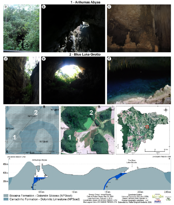
Due to the local limestone fragility, the Anhumas Abyss (Figure 6 "1") developed vertically. Due to water percolation through the rock fractures, the limestone chemical dissolution is related to the Anhumas doline collapse process. The total depth of the abyss reaches 152 meters (adding the lake depth). The Gruta do Lago Azul (Figure 6 "2") has a large hall at the cave entrance, showing transparent blue water through the dolomitic limestones of the Bocaina and Cerradinho Formations. The local landscape and its surroundings present sharp topography and preserved canopy. The Gruta do Lago Azul is one of the most famous Brazilian tourist hotspots. The landscape exhibits a classical karst space, and the carbonate formations are different when compared with terrigenous rock areas, highlighted in the next geological formation, the Aquidauana Formation (Palaeozoic Age).
The Aquidauana Formation is a geological unit of the Itarare Group and occupies an area of 14.000 km2; however, 29.37 km2 is located inside the limits of the study area, in the extreme east sector. The area is located near Formoso River and shows specific aspects, as well-defined horizontal layers (Figure 7) with the predominant presence of siltites, claystones, and mudstones accompanied by clasts and diamictites that trap sandstone layers.
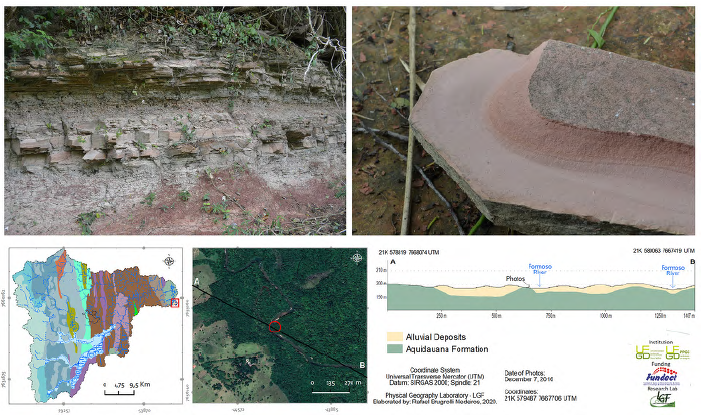
According to Baptista et al. (1984), the Aquidauana Formation comprises tough red sandstones, resilient sandstones showing pink or red spots. The surface presents several pebbles often separated from the thin rock matrix. The topography presents plain to smooth relief, strongly influenced by flood and drought periods of the Formoso River (many places are wet and likely floodable, near the Formoso River mouth). The formation origin is attached to the continental and sedimentary environment in its past, showing mature and deep soils as red dystrophic latosol. Regarding more recent geological features of the study area, we highlight the characteristics of the Serra da Bodoquena Formation (Quaternary Period). The formation is an eminent example of irregular limestone without any structural sediment pattern. The limestones present light brown or light pink, rarely reddish, showing massive rocks with variable porosity (Baptista et al., 1984). The high transparency of the water (from brooks and streams) is a relevant characteristic of the Serra da Bodoquena Formation. The Sucuri River flows above its rocks, highlighting the geological influence, as the area has a high level of dissolved calcium. Thus, the suspended solids that compose the environment configuration allow a decantation process and deposition of solids on the riverbed. The hydric decantation process decreases turbidity and increases translucent water levels.
Previously called the Xaraiés Formation, the tufa deposits, even though some of the lithologies are similar, the lithological characteristics, the existence of clear and abrupt contacts, and the mappability of the tufa made it possible to create a new unit, called the Serra da Bodoquena Formation (Sallun Filho et al., 2009).
The differentiation between the deposits proposed for the new unit (Serra da Bodoquena Formation) and the Xaraiés Formation (in Serra da Bodoquena) is based on: a) the Serra da Bodoquena Formation was originated and is currently situated in a distinct hydrographic basin and karst system; b) the Serra da Bodoquena Formation is deposited on another surface, both distinct of the Xaraiés Formation in Corumbá (Sallun Filho et al., 2009).
Moreover, the tufa identified in the Serra da Bodoquena area are generated by water stream action at the limestone riverbed. According to Sallun Filho et al., 2009, p. 47) the:
"Quaternary tufa deposits occur widely in the Serra da Bodoquena (state of Mato Grosso do Sul, Brazil), associated with the karst system that has developed on carbonate rocks of the Corumbá Group. The deposition of tufa is favored in the Serra da Bodoquena due to the predominance of autogenic waters, which allow for groundwater to be enriched in calcium carbonate".
The water is remarkably alkaline and forms a carbonatic deposit due to the constant hydric friction against the limestone riverbed (Figure 8). Sallun Filho et al. (2009, p. 48) explain that a large number of tufa occur under the following conditions: water with high levels of dissolved calcium; superficial local water with a high level of purity, especially without the presence of silica and clast sediments; high local water biological action; and favourable climate configuration. According to Sallun Filho et al. (2009, p. 48), Bonito is South America's most expressive record of tufa, even with intense tourist activity.
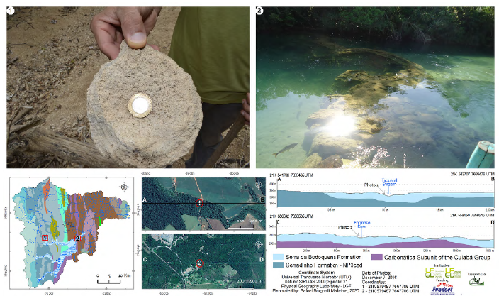
Figure 8 Sedimentary deposit (Photo 1) that origins the famous calcium tufa of Serra da Bodoquena Formation in Bonito Municipal Balneary of Formoso River (Photo 2), Mato Grosso do Sul State, Brazil.
The Serra da Bodoquena Formation occupies 94.32 km2, and it is located along the high and medium course of the Formoso River and Formosinho stream, along all Alegre stream fluvial course, at the low course of Anhumas and Taquaral streams, and the medium and low course of the Sucuri River. The characteristics that define the relevance of its geological formation highlight the alluvial karst plain terrain, native hydrophilic vegetation, and very low slopes. The calcium tufa appear along the drainage areas with high alkalinity, streams or short waterfalls (Figure 8). However, the high calcium levels have attracted the interest of mining activities in the area.
The youngest geological unit of the Formoso River Hydrographic basin is the alluvial deposits of the Holocene. The deposits present unconsolidated sediments, such as sand, silt, clay, and gravel. The terrain is characterized as plain and near fluvial channels, especially at the confluence of Formoso and Miranda Rivers. In addition, the deposits occur near gleisols and areas of preserved forest. The alluvial areas are located at 2.16 km2 (0.16% of the study area). Brugnolli et al. (2023) emphasize that the unit represents sediment from several regional geological compartments; the deposits are little studied and generally classified as colluvial or alluvial sediments. However, they are natural hosts of relevant information on the regional geological evolution that has remarked on the local landscape.
Conclusions
The organization of morphostructural units of the Formoso River Hydrographic basin is characterized by the predominance of carbonate rocks and their systems (Corumba Group). By grouping the karst formations, they represent 860.84 km2 (64.93% of the study area). Nevertheless, the morphostructural units of terrigenous rocks (represented by the Cuiaba Group) occupy 464.90 km2 within the hydrographic basin area, representing 35.07%. The carbonate rocks occur near the Serra da Bodoquena surroundings and in the high and medium course of the hydrographic basin. The terrigenous rocks occur from the central sector of the study area until the Formoso River mouth.
Fifteen different units are classified and describe the morphostructural units ofthe Corumba and Cuiaba Group. Thus, the hydrographic basin relevance is a remarkable model of the richness, beauty, and complex Brazilian landscape. Furthermore, the study area described here is well-known by Brazilians and internationally due to its unique characteristics supporting the region's tourism development. In this way, the present research aimed to contribute relevant technical data about this strategic and unique Brazilian region.
The karst regions of the Formoso River Hydrographic basin exhibit singular topography and influence the regional physical-chemical water quality, with rivers and streams that show some of the most translucent waters in the world, such as the Sucuri River. The tourist sector knows about the regional characteristics of the area. Therefore, preserving the landscapes is a compulsory action that requires rational and effective management effort, entangling the economy and production sectors.
The Formoso River Hydrographic basin is a Brazilian natural treasure that demands attention.

