


 English (pdf)
 Article in xml format
 Article references
 Send this article by e-mail
 Cited by SciELO
  Cited by Google
  Similars in
SciELO
Similars in
SciELO  Similars in Google
 Permalink
Colombians have long known that el sabio Francisco José de Caldas was the patriotic founding father of Colombian geography. Popular narratives portray Caldas as the self-taught, isolated genius from Popayán who developed interests in natural history, geography, and astronomy, but because of his dangerous passion for knowledge, Spanish General Morillo ordered Caldas' execution. When Caldas pleaded for his life, Morillo is rumored to have coldly responded, "Spain has no need for sabios".1 In July of 1810, Caldas opened the doors of Bogotá's astronomical observatory to coconspirators planning to declare independence. Their collective grievances were against the Spanish Cortes, not their beloved Fernando VII. Spanish Reconquista armies radicalized Caldas against monarchy. By 1816, Caldas and other prominent members of New Granada society were arrested, and the massive collections of botanical specimens, drawings, and maps held in the astronomical observatory were confiscated. Caldas was executed. The vast collection of materials was sent back to Spain.2 Patriotic narratives highlighting Caldas' martyrdom have made him the Galileo of Colombia, executed for daring to know.
Partly due to his popular, nationalistic appeal, Caldas has emerged as a central figure in Colombian historiography.3 This essay does not trace out how generations of historians have characterized Caldas' contributions to scientific knowledge in Colombia during the nineteenth and twentieth centuries. Instead, it suggests the value of historicizing how print culture produced founding fathers for political ends. The focus on the specific time period of the 1820s reveals how Gran Colombian officials deployed print culture to delegitimize the Spanish Monarchy so as to legitimize a centralizing Colombian Republic with Bogotá as its capital. The essay contributes to literature examining the role scientific knowledge and print culture played in the assertion of authority4 by demonstrating how Colombian officials tried constituting their authority in and from Bogotá through the dissemination of the official newspaper, the Gaceta de Colombia. Colombian officials deployed the Gaceta to manufacture a three-hundred-year legacy of Spanish Monarchical obscurantism through editorials offering the heinous execution of Caldas as proof. Editing and reprinting Caldas' writings allowed the Gaceta to showcase how the Republic, unlike the Monarchy, dedicated itself to acquiring and disseminating useful knowledge. To that end, the Gaceta also announced official decrees calling for updated geographic information from the provinces, claiming these efforts constituted a civilized and enlightened republican endeavor inspired by Caldas. And yet, as various scholars have shown, the acquisition and circulation of natural knowledge constituted essential mechanisms for establishing and maintaining longdistance monarchical rule for centuries. The Gaceta also cited Caldas' execution to highlight why calls for federalism were so dangerous when Spanish re-invasion still loomed. The only solution for Colombia, argued the Gaceta, was a republican territorial order that placed Bogotá, the capital, at its center. When obvious threats of re-invasion dissipated, the Gaceta's shrill calls for centralism fell on deaf ears. Cities like Quito and Caracas that resented Bogotá's centralizing pretentions seceded from the tenuous union of the first Colombian Republic.
The first section briefly traces the deep and long tradition of natural knowledge collection and circulation that was central to the constitution of Spanish Monarchical rule in the New World in order to best contextualize Caldas' work as editor for the scientific journal, the Semanario del Nuevo Reino de Granada. Much like his mentors before him, Caldas trained younger generations in the arts of natural knowledge production, representation, and how to perform scientific neutrality. Caldas did not seek recognition as a singular, lone genius; on the contrary, he gathered and disseminated knowledge from several sources and local experts. Caldas had learned from his mentor, José Celestino Mutis, who began the practice of disseminating scientific knowledge about the Royal Botanical Expedition through print in the late 18th century.5 What made the Semanario unique was that it was produced during 1808-1810, when the Spanish Monarchy was in crisis. The chaotic uncertainty wrought by transatlantic political transformations meant that representatives of the Spanish Crown in Santafé (Bogotá) maintained strict censorship. Careful wording and contextual knowledge allowed Caldas, and the elite community of reading that his Semanario fostered, to consider patriotic solutions to the threats the Spanish Monarchy faced. Although far from Caldas' original intent, the criollo network of elites that Caldas helped create constituted the cultural and political class best placed to bring order and control for the short-lived Bogotá-centered Colombian Republic that emerged a decade later.
The second section challenges dominant historiographical narratives highlighting caudillos, chaos, and protagonism by men like Bolívar and Santander in the early period of the Colombian Republic6 by showing how Caldas' mentees believed in the political power of print to create a legitimate and legitimizing republican community of reading. The Colombian government supported the production and dissemination of the national newspaper, the Gaceta de Colombia for this purpose. The Gaceta reworked Caldas's life and writings to delegitimize the Spanish Crown while legitimizing a Colombian Republic with the city of Bogotá as its centralizing capital. José Manuel Restrepo became a central figure in this regard. Although Restrepo is best known for his canonical historical writings, most notably the Historia de la Revolución,7 the section traces out a lesser-known dimension of the "first historian" Restrepo. As Colombia's Minister of the Interior and External Relations during the 1820s, Restrepo oversaw the publication of the Gaceta. Much like his mentor Caldas, Restrepo did not seek explicit recognition for himself through this work. Instead, Restrepo worked behind the scenes to create an editorial voice for the Gaceta similar to that of the Semanario, one of measured, scientifically and historically informed neutrality that could speak on behalf of the interests of the Colombian Republic. By the 1820s, the community of reading that the Gaceta fostered expanded well beyond elite letrados of New Granada to encompass far-flung audiences in cities including Maracaibo, Caracas, Guayaquil, and Quito. Not all of these audiences were convinced that a centralizing republican government was the best political arrangement. The Gaceta therefore found in the Galileo-like figure of Caldas a useful way to stoke fears of Spanish barbarism and re-invasion that could legitimize the need for Bogotá's centralizing place in a vulnerable republic. Restrepo played a leading role in efforts to memorialize Caldas for these purposes, and he was not alone.
The third section considers a broader set of geographic practices made visible via the Gaceta that reflect how the cohort of men associated with Caldas and who survived Colombia's Revolutionary War appropriated and operationalized tactics long used by the Spanish Monarchy. They did this to acquire international and national legitimacy for the Colombian Republic's independence. This far-reaching network of men that crossed the Atlantic and populated the variegated provinces of Colombia understood that the work of geography and mapping could convincingly name, lay claim on, and order nature, society, and resources in ways that could serve specific political needs. This was the long-term lesson that Spanish Monarchical rule had taught all of them. And yet, rather than cite the monarchical tradition that shaped their world view, these men exalted Caldas's contributions to geographic knowledge as the model to follow. The Colombian government hired French-trained naturalists for the international acclaim they could win for the Republic through their scientific mapping of the country's mineral and natural wealth. The Gaceta complemented the work of the foreign naturalists by announcing official decrees ordering provincial authorities to send in reports and maps with astronomical measurements and information on the local population. Hundreds of reports from the provinces poured into the Executive Power in Bogotá that detailed local conflicts regarding control over land, people, and resources.8 Compliance by provincial officials suggests a dynamic that shifted territorial communications away from Spain and towards Bogotá as the place that could effectively arbitrate questions of municipal status and boundaries. These local conflicts are not visible on the final map Restrepo printed in Paris in 1827, one that needed to ensure the stable unity of the republic for foreign audiences.9 Neither could the map show the fact that, by 1826, with the threat of Spanish re-invasion gone, territorial fragmentation loomed.
New Granada Print Culture Patriotically Defends Monarchy
Francisco José de Caldas was just one of thousands engaged in producing natural knowledge for the Spanish Crown over the course of generations.10
Beyond participating in New Granada's Royal Botanical Expedition and overseeing the newly built astronomical observatory in Bogotá, Caldas' activities included editing the Semanario del Nuevo Reino de Granada during a critical turning point for the Spanish Monarchy. The Semanario's first issue ran in January of 1808, just months before the Spanish Kings' abdications at Bayonne. This timing, together with Caldas' continuing need for support from royal authorities, explains the deference and loyalty the Semanario displayed towards the Monarchy well into 1810. Caldas was not staking out epistemological independence from Spain through his weekly scientific journal. On the contrary, his was a decidedly patriotic publication championing a tradition of enlightened knowledge production that positioned criollos as co-creators of that knowledge. Caldas' patriotism was not just about duty to the land of his birth, that is, the Kingdom of New Granada, but, more significantly, to the Spanish Monarchy more broadly.
Caldas and his cohort extolled the circulation of people and ideas from New Granada to European cities and back because this process was essential for gaining and disseminating skills and learning throughout the Spanish Empire. A careful reading of Caldas' effusive celebration of José María Cabal's return after seven years studying chemistry in Cadiz, Madrid, and Paris reveals this commonly held core value. Cabal's was an act of a "good citizen", one who "abandoned Europe and all of its pageantry in order to bring to the heart of his fatherland needed enlightenment".11 Some scholars have accurately read Caldas' report on Cabal's return as articulating an elite creole belief in their sacred civilizing mission to educate.12 Situating this text within its tumultuous transatlantic context allows us to see beyond this sacred educational mission and envision the deep loyalty to the Spanish Monarchy that Caldas attributed to Cabal's actions. By 1809, several chemists with a background similar to that of Cabal's joined hundreds of other Spanish scientific authorities that remained in Spain in support of the invading Bonaparte regime. These men, later known derisively as the "afrancesados", won high positions in Madrid under Bonaparte.13 Cabal could have joined his fortunes with the afrancesados in Madrid. He chose not to. Vigilant censorship blocked Caldas from explicitly mentioning either Bonaparte or the afrancesados in his Semanario. Caldas instead made oblique references to both by alluding to the prestige and honors Cabal renounced by leaving a Madrid dominated by the Bonaparte regime. That Cabal returned proved his patriotism and loyalty not just to New Granada, but to the Spanish Monarchy more broadly.
The Semanario's tense silence on European events from 1808-1810 did not mean its editor and contributors were detached from the political turmoil that exploded throughout the Spanish Atlantic Monarchy. By 1809, the year of Cabal's arrival, Caldas and his cohort had received conflicting news of Napoleon's invasion. Elites in Santafé knew about King Carlos IV and Fernando VII's abdications to Bonaparte and they knew about the resistance movements sprouting up against Napoleon throughout the Spanish Empire.14 They also worried about the Spanish Cortes. In 1810, Caldas declared his disaffection with the Spanish Junta in footnotes to the Semanario.15 Caldas followed his printed words of protest against the "mal gobierno" of the Cortes with deeds. He demonstrated his loyalty to Fernando VII by helping plot the declaration of independence in Santafé, launched on July 20, 1810. Caldas hedged his bets by not leaving any official trace of his actions.16 He nevertheless stopped work on the Semanario after the Santafé Junta formed. He joined Joaquín Camacho at the Diario Político de Santafé de Bogotá, a paper dedicated to winning public opinion for the autonomy of the Santafé 1810 Junta while maintaining loyalty to Fernando VII. In short, Caldas witnessed -and participated in- significant political changes from 1808-1810. Throughout that short period, he remained loyal to a monarchy that supported the production of natural history knowledge.
Caldas' public writings in the Semanario from 1808-1810, along with his private correspondence, offer a powerful avenue for understanding how he and his cohort tried to assert legitimate political control in a time of crisis: by forming a networked reading community that spanned New Granada provinces and contributed to the neutral, detached language of science. Mauricio Nieto-Olarte has astutely observed how, through the publication of the Semanario, Spanish American ilustrados asserted their interests as if they represented the universal needs of the entirety of the Kingdom of New Granada.17 By constructing the Semanario's methods and ends as neutral, absolute, and universal, and as the product of trained, qualified minds, Caldas placed control over New Granada's nature in the hands of the "good Citizens" who contributed to the publication.18 Exemplary men who understood the duties and responsibility of citizenship transmitted their knowledge through the Semanario's pages. Several social settings outside of the Semanario facilitated Caldas' efforts, most notably tertulias.19 Exclusive face-to-face meetings and epistolary correspondence helped cement relations of trust and authority between Caldas and the men whose contributions he highlighted. Focused, enlightened discussion among a community of actively engaged citizens generated useful, neutral knowledge for the Kingdom of New Granada and the Spanish Monarchy as a whole.
The dozens of good citizens Caldas mentored in this practice of performing neutrality through the Semanario included the young Antioqueño criollo Jose Manuel Restrepo. The Semanario's fourth volume dedicated almost three pages of footnote space to the geographic findings of "the hard working, enlightened youth, D. Joseph Manuel de Restrepo".20 A year later, the Semanario featured Restrepo's geographic description of Antioquia, catapulting Restrepo into the highest echelons of New Granada inteligencia.21 In addition to his written reports to Caldas, Restrepo drew several maps and plans of his natal province and consulted their accuracy with Caldas. Caldas rigorously critiqued Restrepo's cartographic work and Restrepo complied.22 As these men defined New Granada cartographic conventions, they enhanced the kind of prestige and authority they wielded within the Spanish Monarchy given the benefits that would come from effective abstract representations of territory.
There is, nevertheless, an underexplored dimension of the construction of this social group's power: geography. This was not just because they represented territory through maps. The production of the Semanario was itself an exercise in geographic circulation, with Bogotá serving as the heart of the New Granada Kingdom. The Semanario, after all, was edited from Santafé. Caldas' efforts to synthesize all existing geographic knowledge about New Granada meant he needed to leave his natal province of Popayán for the physical capital of the viceroyalty, where he could access the printing press and benefit from viceregal dynamics of mail collection and distribution. Santafé also was the main site of the social gatherings in private homes where scientific and geographic ideas were discussed. Not surprisingly, elites from other places New Granada also were drawn to the cultural and scientific center of Santafé. This was the case for Antioqueño-born Restrepo, who, after receiving recognition in the Semanario, also moved to Santafé. The essays and treatises Caldas edited and printed in his Semanario worked to generate the conventions that described, delimited and claimed New Granada's territory in ways that placed Spanish American creole elites at its top, and Santafé at its center.
Between 1810-1815, as the Spanish Monarchical crisis escalated, this Santafé-centered network of authority came under fire. Recent studies have rightly emphasized how the political crisis engendered by the Napoleonic invasion of Iberia ignited an explosion of sovereignties throughout the Spanish Empire.23 When faced with crisis, Hispanic legal scholars argued that in the absence of the legitimate king, sovereignty reverted to the "pueblos", a term that referred to organized towns rather than a disorganized mass of people. Caldas supported efforts by several criollos who claimed sovereignty for Santafé in July of 1810. Despite the important network of criollo elites in Santafé that emerged through the Semanario from 1808-1810, Santafé was not the only city claiming sovereignty in the absence of a legitimate monarch. A growing number of cities claimed the right to municipal government from 1810-1815. Towns that previously lacked a political voice within the Spanish Empire took advantage of the crisis and represented their interests directly to the provisional Cortes government in Spain. This mushrooming of municipal governance was especially intense in the New Granada Viceroyalty.24
Larger cities considered that the newly formed municipalities were illegitimate and resented these moves towards autonomy. The perceived illegitimacy of the Spanish Cortes, together with the mushrooming of municipalities in Spanish America forced the capitals of colonial-era partidos, corregimientos, capitanías, and viceroyalties to try to recreate the administrative spatial hegemonies lost to the political turmoil unleashed by Napoleon. They negotiated constitutional arrangements with emerging communities of vecinos in countless towns with newly minted municipalidad. The newly founded cities were determined not to lose their recently acquired rights of political representation during the early period of independence. The arrival of Spanish royalist armies, insufficient resources, and decimated populations forced several of these new municipalities to the negotiating table nonetheless. By December 1819, in the wake of Bolívar's victory at Boyacá, pro-independence generals passed the Foundational Law uniting the former Captaincy General of Venezuela with the former New Granada Viceroyalty and the Audiencia de Quito under the Colombian Republic.
Colombian Print Culture Invents an Obscurantist Monarchy
The first Colombian Congress met in the city of Cúcuta on the border between Venezuela and New Granada in 1821, approved the formation of a united Colombian Republic, passed Colombia's first Constitution, and offered provisional definitions for Colombia's territorial organization.25 Centralizing power in the Colombian Republic allowed for the quick mobilization of resources to the places that needed defense against the royalists. In the wake of conflicts over territorial sovereignty during the interregnum from 1808-1815, several lawmakers eyed Bogotá's capital city status with suspicion. Those from Venezuela worried about the dominance Bogotá could display over other cities after royalists were defeated. Bolívar himself had ordained through his Jamaica Letter of 1815 that if New Granada joined Venezuela as a single republic, then the capital city needed to be either Maracaibo in Venezuela, or another new city that could be defended against the Spanish. Bogotá therefore became the capital of the Colombian Republic in 1821, but only temporarily so. Congress stipulated that a new "Ciudad Bolívar" should be founded in a location that served the needs of every Colombian department. Given continued circumstances of war, Bogotá would have to do in the meantime.26 Not only was Bogotá the provisional capital, so was the 1821 Cúcuta Constitution, which would come up for revision if royalist forces were defeated within ten years.27 Despite the provisional nature of Colombia's political and territorial order, Bogotá-based elites believed they could solidify Bogotá's place as centralizing capital for the republic and deployed the official newspaper, the Gaceta de Colombia, toward that end.
The Gaceta enjoyed significant circulation at the cost of the government, and several people were involved in the paper's content and production.28 While the Constituent Congress held sessions in Cúcuta, radical republican Miguel Santamaría edited the paper from that city. After Vice President Francisco de Paula Santander moved the Gaceta's operations to Bogotá in 1821, Vicente Azuero served as interim editor.29 Early in 1822, Azuero resigned.30 José Manuel Restrepo, then Minister of the Interior, presented Casimiro Calvo to Santander as the new editor for the Gaceta, stipulating that Restrepo "should know every detail that the printer publishes, should open all communications from the tribunals and courts to the writer of the Gaceta, and should create a stipend from the profits generated by the Gaceta for official work on the paper".31 Restrepo therefore had significant influence over the content of the Gaceta after Calvo's March 1822 appointment.
By late March 1822, Restrepo found three interrelated state-building purposes for re-publishing selections from Caldas' Semanario. First, the Spanish Monarchy could be delegitimized as obscurantist and tyrannical given that it imposed ignorance among local populations by executing men like Caldas. Second, Caldas' martyrdom and his writings legitimatized a centralizing Colombian Republic with Bogotá as its capital, the only political-territorial arrangement that could fight against a looming Spanish re invasion. Finally, the Gaceta could claim the tactics the Colombian government used to gather and circulate natural knowledge about the republic were inspired on Caldas, not the long trajectory of Monarchical rule.
The Gaceta denounced Spain's cruel execution of Francisco José de Caldas on March 31, 1822, six years after the torrent of condemnations that flooded international and national papers immediately in the wake of Morillo's reign of terror.32 Caldas consistently evinced a moderate temper to his mentees, the Gaceta wrote. He had been a peaceful man, yet Spain "honored" Caldas with torture and death.33 The time lag suggests that shock over Caldas's execution was not the main reason motivating the Gaceta's editorial decision to re-print Caldas' works. As the Gaceta explained, Colombia was opening its relations with all the peoples of the earth and needed to be known not just for its military triumphs and for its politics, but also for its "position, wealth, and natural advantages".34 The Gaceta shifted gears from outrage at Caldas' martyrdom to the benefits Caldas' unique descriptions would bring to the new republic. The Gaceta's editorial voice channeled Caldas to present itself as the civilized defender of the republic against the tyranny and obscurantism of the Spanish Monarchy and against the chaos of 'federalism' that had brought reconquest and death only a few years before.
Caldas' words from 1808 defending the acquisition of natural knowledge in defense of the Spanish Monarchy were re-deployed in the 1822 Gaceta to legitimate expansive territorial claims for a Colombia that needed Bogotá as its centralizing capital city. In one broad sweep, the Gaceta re-printed Caldas' matter-of-fact description of a 'natural' territory subject to the city of Santafé de Bogotá.35 The political dominance of Santafé as the capital city of the Viceroyalty became a geographic fact, a simple point of departure for understanding what Caldas meant by "New Granada." This scientific naturalization of Santafé's jurisdiction in 1808 became useful for officials in Bogotá at a time when Colombia had not yet settled on the location of its capital city after the Cúcuta Congress had adjourned. Beyond the shifting location of Colombia's capital loomed an even more serious threat: federalism.
The federalism that threatened Colombia's unity in 1822 was not the same fragmenting sovereignty characteristic of the period of the interregnum briefly described above and that Bolívar denounced in his Jamaica letter of 1815.36 By 1819, smaller municipalities no longer saw advantages to asserting autonomy from larger urban centers. Cries for federalism instead came from traditionally dominant cities, those like Quito, Valencia, Guayaquil, or Caracas that resented Bogotá's claims to dominance after the formation of the Colombian Republic. Despite this distinct change, the Gaceta argued that the past had taught Colombians that federalism would result in a Spanish re-invasion, and invoked the chaotic experience of the first period of the revolution as proof.37 Federalism, the Gaceta argued, made it impossible to fight off Reconquista armies. Caldas and several others paid for the chaos of federalism with their lives. This narrative not only obscured the complex struggles for autonomy and independence that smaller urban centers sought from historically more dominant cities during the interregnum; it also allowed the Gaceta to argue that, as long as the threat of Spanish reinvasion lingered, the centralization of power in Bogotá made sense.
Caldas' invocation of the providential benefits that would come to a Kingdom located at the center of all the world's major trading routes, with its fertile mountainsides capable of producing every possible commodity on the face of the earth, became the carrot to the stick of the specter of federalism. Drawing from Caldas' writings on the influence climate had on the human race, the Gaceta argued that circulation through a centralized Colombia would bring political unity to a diverse population. Concentrating political and military power was the only way to ensure equilibrium and unity among so many diverse populations.
The current system [centralism] creates the conditions that allow for intimate ties to emerge between the inhabitants of the Orinoco with those of Guayaquil, the son of Caracas with that of Quito, the daring plainsman with the shy indigenous man, the inhabitant of searing sands of the coasts with that of the frozen mountaintops of Tunja.38
Caldas' mentees would, through the force of political, military, and territorial centralization, bring the providential future that the sabio had envisioned for the Spanish Kingdom of New Granada to the entirety of the Colombian Republic. Royalist forces would be defeated. The circulation of people and products would bring prosperity. Centralism could not go wrong with Bogotá, as the capital city, coordinating these moves. Officials based in Bogotá then turned to the third, and most significant way they could use Caldas' legacy to secure Colombian state formation. By underscoring Caldas martyrdom at the hands of an obscurantist Monarchy, officials appropriated long-standing Spanish techniques of asserting territorial control as if these practices were unique, enlightened republican endeavors.
Republican Information Gathering Strategies Modeled on the Spanish Monarchy
Gathering precise geographic knowledge from provincial authorities had long been a central feature of Spanish Monarchical rule in the New World.39 But to gain international and national legitimacy, the Colombian Republic needed to erase local and international memories of this long-standing monarchical tradition. By the 1820s, several criollo letrados loosely associated with Caldas' Semanario network held key positions of leadership with the Colombian government in Bogotá, in the provinces, or as diplomats in Europe. These men understood how natural history, geography, and cartography could be paired with diplomacy and print culture to legitimize the Colombian Republic's independence thereby delegitimizing the Spanish Monarchy's claims to rule.
Take, for instance, Francisco Antonio Zea, a former colleague of Caldas's in New Granada's Botanical Expedition, who hired an expedition of French-trained naturalists in Colombia's name.40 "The enthusiasm this expedition has excited among the wise men of Europe is incredible", Zea wrote to Colombia's Minister of External Relations, Pedro Gual.41 The work of these experts would prove useful not just for Colombian natural history, but also for the purposes of Colombian independence. By November 1821, when Zea penned his letter, only the United States had recognized Colombia's existence. Hiring the experts would show the world how Colombia, not Spain, had asserted definitive and stable military control over northwestern South America.42 Rather than keeping natural knowledge within the confines of the Spanish Monarchy, this cosmopolitan group with ties to Paris' Natural History Museum would prove that Colombian independence augured well for the expansion of sciences and civilization more broadly. Venezuelan generals long suspicious of former Vice President Zea's political maneuvers did not immediately welcome the French-trained naturalists when they arrived at the port of La Guaira.43 Colombian officials in Bogotá, however, were excited by their arrival in the capital city.
Just prior to the expedition's Bogotá arrival, the Gaceta invited Colombian citizens to participate in a geographic and statistical information gathering exercise. The Gaceta welcomed any information that would "contribute to making known some part of the territory of the Republic or its provinces".44 Rebecca Earle has observed that the overwhelming majority of Colombia's population was largely illiterate around the time of independence.45
Despite low literacy levels, other scholars have shown how public readings of newspapers in public spaces disseminated information quickly in urban areas.46 This request by the Gaceta was specifically targeted at the letrado elites of Colombian provinces, however. Restrepo and the rest of the editorial board of Colombia's official newspaper knew how the Gaceta circulated and who were its primary readers. Those who received the Gaceta were either government officials themselves, editors of other newspapers, or wealthy enough to have a privileged education and could afford a subscription. Influencing the opinion of these literate citizens in the capital cities of Colombian provinces proved crucial. They could make or break the Republic. Restrepo targeted his open appeal for geographic knowledge from these valuable citizens, not only because they most likely could fulfill the request, but also to actively engage their patriotism for Colombia, just as the "good Citizens" of the New Granada Kingdom had done through the Semanario.
The arrival of the French-trained naturalists in Bogotá in 1823, together with urgings by an array of Colombian officials, convinced Vice President Santander to launch a more systematic geographic information gathering effort. Already in 1820, Restrepo had written Santander requesting geographic information for an accurate map of the Colombian Republic to display to international audiences.47 By 1823, the Colombian diplomatic corps in Europe urged officials to hurry the production of a clear map; the British already had designs on Colombian territory.48 The naturalists' arrival seemed to offer a path towards fulfilling the geographic mapping project that Caldas had envisioned in 1808.49 To that end, Colombian officials in Bogotá passed several decrees facilitating the work of the naturalists. The printing press in Bogotá disseminated some of the expedition's early findings.50 Bogotá also inaugurated its version of a natural history museum where the naturalists educated Colombia's young elite in mineralogy, biology, chemistry and other natural sciences.51 The Republic then created a depository in Bogotá for "geographic and hydrographic charts, observations, and other important news for the formation of the general map of Colombia".52 Finally, the Gaceta disseminated Santander's 1823 decree requiring provincial officials to turn in detailed maps and sophisticated geographic reports to Restrepo in Bogotá.53 Response to this decree was remarkable.
Over the course of two years, hundreds of responses poured into Restrepo's office. The most active respondents were the jefes políticos, the highest executive power in municipal capitals.54 More often than not, jefes políticos turned in a basic graph chart that explained what parish towns were included within the jurisdiction of the canton they oversaw, and tallied the population, parish by parish. Occasionally, several jefes políticos did send in geographic map images, offering profuse apologies for the lack of geographic knowledge in their jurisdiction.55
Beyond supplying the Ministry of Interior with graphic or descriptive verbal maps of local territories, these reports served a valuable political function. Most immediately, local government officials called on the central government to resolve territorial disputes and municipal jurisdictions in their favor. Self-proclaimed cabildos made up of a town's local elite also sent in petitions illustrated by maps to convince the Colombian government that their city required official municipal status, citing the "patriotic" sacrifices their town made for the cause of independence.56 These responses, paired with the decree allowing for a centralized archive of geographic information, reveal how the Colombian Republic understood the value of having geographic information from several different regions centered in one place. This was, after all, a long-standing tradition within the Spanish Monarchy. This information-gathering technique became a formal strategy for building state capacity.
The Colombian Republic attempted to make far-flung territories readable. Clear guidelines decreed in laws would allow local officials to follow a standardized method. The practice of gathering local geographical information, disciplining that information to suit the requirements of national decrees, and then submitting information from the provinces to the central government in Bogotá appealed to the needs of a centralizing republican government regime. Reports were centralized, processed, and archived by the office of the Ministry of Interior, headed by Restrepo.
Provincial officials, in turn, understood that whoever had the ear of the central government would probably be most favored when it came time to resolve territorial disputes. The central government in Bogotá would not only gain knowledge about local conflicts over territory, but also identify who were the most faithful and trustworthy local politicians. This information could be used as leverage: Bogotá would serve as the highest-level arbiter for local disputes, a role formerly served by the Monarchy in Spain. This role could secure Bogotá's legitimacy as Colombia's capital city. What these maps did not do, however, was directly impact how the cabinet of cartographers in Bogotá drew out the national map of Colombia.
José Manuel Restrepo understood that the hundreds of sketches and reports sent in to the government in Bogotá would be impossible to include in the kind of cartographic project he envisioned for international circulation. Restrepo needed a scientifically informed map of Colombia that would win recognition of its independence from all foreign powers. Making visible local rivalries over jurisdictions could call into question the permanency of Colombia's territorial claims. The printed version of the map of Colombia that emerged in Paris in 1827 sidestepped the many unresolved disputes over municipal jurisdictions.
Rather than resolve local territorial disputes through a map of the Colombian Republic, Restrepo's project was primarily intended to underscore the reality of Colombia's revolution and serve as a visual aid for the historical account that it illustrated.57 Restrepo and those who contributed to the formation of the expedition of French-trained naturalists, as well as his cabinet of cartographers, expected that the world would see and acknowledge the cartographic knowledge produced by Colombia's leaders. This would be proof of Colombian enlightenment and legitimacy to rule. Diplomacy, natural history, and cartography seemed to be paying off on the international stage. Britain had joined the United States in recognizing Spanish American independence, and other powers were poised to do the same. Unfortunately for the editors of the Gaceta, diplomatic success brought national dissolution.
By 1826, as Spanish forces withdrew from South America, the territorial tensions that the Gaceta railed against began to pull the Republic apart.58 Starting in 1830, Venezuela and Ecuador seceded from Colombia, led by their dominant urban centers. By February 1832, representatives from twelve cities signed off on a new constitution creating the New Granada Republic. The cities that joined Bogotá -and those who refused to do so-reflected how large cities dominated the territorial changes and negotiations that ensued, yet some new urban players asserted their political rights too. Although ten of the signatory cities enjoyed status as corregimientos or gobernaciones within the New Granada Viceroyalty prior to independence,59 Mompox, which previously had been subject to Cartagena, emerged as a new provincial capital.60 Notably absent from the 1832 agreement was Casanare, whose leadership was torn between joining Venezuela or New Granada, even though the Venezuelan Congress refused Casanare's addition to their territory.61 Chocó and Popayán also had yet to pledge allegiance either to New Granada or Ecuador, in part because of the shared jurisdiction that Quito and Santafé exercised over these cities during the period of Spanish Monarchical rule. As New Granada continued to work out territorial negotiations, prominent leaders again redeployed colonial-era strategies for asserting territorial control and continued to present these efforts as notable and unique republican endeavors inspired in Francisco José de Caldas. This explains why, by 1849, on the eve of the Chorographic Commission's deployment to map New Granada's territory, the independence war veteran and geographer, Colonel Joaquín Acosta, edited and re-published Caldas' Semanario in Paris.62 Lino de Pombo joined Acosta's mid-century memorialization of Caldas with a biography of el sabio in 1852.63
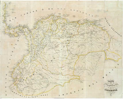
Source: José Manuel Restrepo, Carta de la República de Colombia. Map. [ca. 1:5.500.000]. Paris: Librería Americana, 1827. Available at David Rumsey Map Collection, Cartography Associates: https://www.davidrumsey.com/luna/servlet/s7kek5z2.
Figure 1 Carta de la República de Colombia (1827).
Conclusion
Examining the history of how Caldas' mentees posthumously re-printed and re-deployed his reflections on political economy and proposals for geographic knowledge in the 1820s reveals underappreciated dimensions of early republican print culture in Spanish America. Most notably, the materiality of print meant that the cities with printing presses became critical nerve centers for the networks of literate criollo elites seeking to legitimize their authority. From 1808-1810, members of this growing republic of letters, no matter their province of origin, turned to printing presses located in Santafé to assert their legitimacy as the good "citizens" with the right to establish needed policies as part of the Spanish Monarchy. By the 1820s, New Granada criollo elites who survived independence employed print to establish their legitimacy to rule a republic independent of the illegitimate Spanish Monarchy. Bogotá, once again, facilitated printed circulation of their proposals. Bogotá elites expanded the functions of print culture by circulating decrees, laws, and petitions through the official national newspaper, seeking to make the Gaceta de Colombia a metonym for the Republic as a whole. In turn, manuscript information, including geographic reports, maps, and population data from the provinces circulated back to Bogotá.
Colombia's capital was ultimately unsuccessful at incorporating large and influential cities that chafed under Bogotá's rule. The built-in provisional nature of the Colombian Republic, and Bogotá's temporary status as its capital city, overwhelmed Bogotá-centered print culture, no matter how much its functions and reach expanded, and no matter how much it venerated enlightened criollo knowledge. This crumbling of Bogotá-centered rule for Gran Colombia points to the circulatory limits of newspapers, maps, and geographic knowledge in producing imaginable national communities.64 Beyond peripatetic patriot criollos barred from assuming high-ranking positions with the Spanish Monarchy, this essay underscores the strategic ways early nineteenth-century print culture from Bogotá tried to legitimate that city's capital status within Gran Colombia, despite the array of forces pulling the early republic apart.

