


Serviços Personalizados
Journal
Artigo
 Inglês (pdf)
 Artigo em XML
 Referências do artigo
 Enviar este artigo por email
Indicadores
-
 Citado por SciELO
 -
 Acessos
Links relacionados
-
 Citado por Google
 -
 Similares em
SciELO
Similares em
SciELO -
 Similares em Google
Compartilhar

 Permalink
Ingeniería e Investigación
versão impressa ISSN 0120-5609
Ing. Investig. v.28 n.3 Bogotá Set./dez. 2008
Teresa Cristina Tarlé Pissarra1, Flavia Mazzer Rodrigues2, Christiano Luna Arraes3, João Antonio Galbiatti4 y Maurício José Borges5
1 Ingeniera agrónoma. Profesora, FCAV/UNESP/Jaboticabal, São Paulo, Brasil. teresapissarra@hotmail.com, teresap@fcav.unesp.br
2 Ingeniera agrónoma, FCAV/UNESP/Jaboticabal, São Paulo, Brasil. Vinculada, Departamento de Engenharia Rural - UNESP/Jaboticabal, São Paulo, Brasil. flamazzer@hotmail.com
3 Ingeniero agrónomo, UFV Universidade Federal de Viçosa, Minas Geraisl, Brasil. Pós – Graduando, Departamento de Solos e Adobos - UNESP/Jaboticabal, São Paulo, Brasil. christianoarraes@yahoo.com.br
4 Ingeniero agrónomo. Profesor, FCAV/UNESP/Jaboticabal, São Paulo, Brasil. galbi@fcav.unesp.br
5 Ingeniero agrónomo. Profesor, Instituto Taquaritinguense de Ensino Superior ITES, Taquaritinga, São Paulo, Brasil. mjborges@fcav.unesp.br
ABSTRACT
Topographical characteristics and water quality were evaluated at Hacienda Gloria, in Jaboticabal, São Paulo State, Brazil. Understanding the reliefs morphometric characteristics and the course of the streams in a small watershed supported the hypothesis that land-use affects water quality and helps predict how changes in water-flow and the surrounding landscape occur; areas protected by native forest and those dedicated to agriculture were considered. Water quality was sampled at six sites and physical and chemical changes were analysed. Monthly water samples were collected from the streams on the same day of each month during the course of a year; Horiba equipment was used for recording data. One-way analysis of variance (ANOVA) was used for determining differences between the sites being investigated. Analysing the data revealed significant differences in pH, electric conductivity, turbidity, dissolved oxygen and temperature. Topographical characteristics have been influenced by agricultural activity, thereby having an environmental impact. Surface runoff was predominant on steep slopes, mainly in areas near the top of the watershed. Land-use has had a significant impact on many physical parameters, including stream turbidity and temperature which increased with deforestation. The results indicated the agricultural watersheds fragility to pollutant exposure and/ or toxicity, mainly due to turbidity in the streams caused by soil erosion, waste discharge and runoff.
Keywords: relief, morphometric characteristics, watershed, environment, land-use management.
RESUMEN
Se evaluaron características topográficas y muestras de agua en un cauce de la hacienda Gloria, municipio Jaboticabal, São Paulo, Brasil. Las características morfométricas del relieve y del agua fueron estudiadas en una pequeña cuenca hidrográfica, considerando zonas protegidas con bosque nativo y aquellas que presentaban uso agrícola de la tierra para ajustar la hipótesis de que el uso de ella afecta la calidad del agua y ayuda a predecir cómo se producen los cambios en este y en el local paisaje circundante. La calidad del agua fue evaluada en seis sitios y se analizaron los cambios de los parámetros físicos y químicos. Las muestras fueron recolectadas el mismo día de cada mes, durante un año, mediante un equipo de Horiba. Para determinar diferencias entre los sitios estudiados se realizó el análisis de varianza (Anova). El análisis de los datos presentó diferencias significativas de pH, conductividad eléctrica, turbidez, oxígeno disuelto y temperatura. Las características topográficas han sido influenciadas por las actividades agrícolas, impactando el medio ambiente. La escorrentía superficial es predominante en las laderas pronunciadas, sobre todo en las zonas altas de la cuenca. Los resultados indican la fragilidad de la cuenca agrícola a la exposición de contaminantes o agentes tóxicos, debido a la turbidez en el agua causada por la erosión de los suelos, la deposición de residuos agrícolas y por la escorrentía superficial.
Palabras clave: características morfométricas, cuenca hidrográfica, medio ambiente, uso do solo.
Recibido: abril 15 de 2008
Aceptado: noviembre 4 de 2008
Introduction
The study of the watersheds natural characteristic, the catchment areas morphology, the geological and hydrological conditions and the main anthropogenic factors affecting water quality (land-use) are becoming more and more important in watershed management development for sustainable agricultural activity. An important issue concerns how land-use and water quality is evaluated and how the impact of management practices is assessed (Caruso, 2002; Arcova and Cicco, 1999).
The topographical characteristics and control of physical-chemical characteristics such as pH, conductivity, dissolved oxygen, turbidity and water temperature have been used as indicators of degradation in the environment and such studies have increasing during recent years (Tong and Chen, 2002; Sliva and Williams, 2001). Pissarra (2002) and Rodrigues (2004) have studied land-use in watersheds and its relationship to topographical characteristics.
Monitoring water quality data regarding watersheds has been used for supporting a number of activities relating to agriculture and productive foresty systems in rural areas and for developing urban areas. A number of state and federal laws require ambient water quality monitoring (Braga et al., 2005; Hallock and Ehinger, 2003). The stated aim of the Brazilian National Water Agency (BNWA) is to implement and coordinate the integrated management of shared water resources and regulate access to water, promoting its sustainable use for the benefit of current and future generations.
Measuring water quality is an important parameter for monitoring rural area activity as deforestation has many significant ecological and biodiversity consequences which will change the degree of an ecosystems functionality or health.
Stream flow can be altered by human activity. The present study was aimed at analysing upstream water quality in two different catchment areas: a forested stream watershed and a deforested stream watershed. The influence of the reliefs morphometric characteristics arising from upland erosion was also analysed, upstream with the spring protected by native forest and another area dedicated to agricultural activity. Comparisons were made between cropped area, pasture and native forest land-use in terms of erosion. The potential benefits of native forest and an improved understanding of the environmental factors and their influence on land degradation in watersheds are discussed; the foregoing can aid agricultural land owners seeking to minimise the extent, degree and rate of their lands soil degradation.
Material and Methods
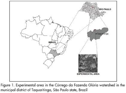
The experimental area was located in Córrego da Fazenda Glória watershed in the municipal district of Taquaritinga, São Paulo state, Brazil (21o 21'S, 48o 31'W.Gr) (Figure 1). The climate is tropical with 1,200 mm annual rainfall and temperature ranging from 22oC in summer to 18oC in winter (Köeppen Classification-Cw). Altitude varies between 578 and 722m. The major soil type is Red-Yellow Argisol, eutrophic text, sandy/medium, undulating relief, moderate A - oxysol (Oliveira et al., 1999).
Topographic factors were studied by photointerpretation based on the São Paulo state Aerophotographic Cover Survey (Politano and Pissarra, 1999). Photointerpretation techniques were used to draw the drainage network and respective captions for dimensional analysis and evaluating the selected variables. Morphometric characteristics must be evaluated for studying drainage basins and common dimensions. The Strahler (1957) stream order system was used. The drainage network was separated into components permitting quantitative measurement on how drainage networks and basins were developed. The number of streams, area and contours were measured and the length of the upper and lower contours for each basin were related to relief. Altimetry amplitude (H) is the difference in elevation between the mouth and the highest point on the watershed divide in area-altitude analysis. Dividing the area of the contour by relative mean length gives a rough mean width (horizontal distance) for the belt. Dividing the contour interval by mean width can determine the grounds mean slope within the particular contour belt. The vertical dimension of a basin whose relief is H may also be expressed as a simple function. The relief characteristics evaluated were: altimetry amplitude, relief ratio (the ratio of the difference in elevation between the basin mouth and the highest point on the basin perimeter to basin length), relative relief ratio (relating basin area to the square of basin length), roughness number (product of relief (H) and drainage density); and average basin slope (Strahler, 1958, Pissarra, 2002). Soil distribution within the basin indicated the ratio in which the erosion occurred (Politano and Pissarra, 1999); dimensional analysis gave an estimate of slope steepness in the watershed in question.
The spatial database consisted of land coverage maps of the drainage network, soil units, erosion and native and agricultural vegetation derived from the aerial photographs (scale 1:30.000) and field surveys. The maps were digitised into ARC/INFO and processed using a Geographic Information System-SPRING/INPE. Overlays were made between land-use, erosion and drainage network maps for analytical purposes, thereby generating a digital database and thematic map. States of erosion were evaluated referring to the wearing away of the land surface resulting from agricultural activity and natural vegetation communities, as related to relief characteristics.
Accelerated erosion was established in 5 units as follows:
State (0): natural erosion (natural environmental conditions undisturbed by man), erosion was not evident in natural cover on photographic images;
State (1): normal erosion (the gradual erosion of land used by man which does not greatly exceed natural erosion), the erosion was not evident in agricultural cover on photographic images;
State (2): rill erosion (erosion in which numerous small channels of only several centimetres depth are formed), erosion was slightly evident in cultivated soils on photographic images;
State (3): sheet erosion (the removal of soil from land surface by rainfall and surface runoff, often interpreted to include rill and inter-rill erosion), erosion was more evident in cultivated soils on photographic images;
State (4): deep rill or inter-rill erosion (the removal of a fairly uniform layer of soil due to raindrop impact and by shallow surface flow; the channels eroded into soil surface by runoff which can still be filled and removed by tillage), erosion was more evident in soil preparation conditions and cultivated soils on photographic images;
State (5): gully erosion (erosion whereby water accumulates in narrow channels and, over short periods, removes the soil from this narrow area to considerable depths, ranging from 0.5 m to as much as 30 m, considered as badlands), erosion was the most evident in soil preparation conditions and cultivated soils on photographic images.
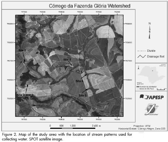
Physical parameters (temperature and turbidity) and chemical parameters (pH, dissolved oxygen and water conductivity) were evaluated according to SMEWW/APHA (1995), using Horiba equipment for collecting data at six sites in the watersheds upstream area and SPOT-4 satellite images. 10 meter resolution was used for visual image interpretation of landuse (Figure 2). Data was collected at each sample collection site. The statistical analysis determined the significant difference in physical parameters between native forest and agricultural land-use watersheds. One-way analysis of variance (ANOVA) was used for investigated sites.
Results and Discussion
Dimensional analysis used in combination with each basins length, width, height (relief) and area has many applications. The average of relief characteristics, altimetry amplitude (H=80.57), relief ratio (Rr=50.32), relative relief ratio (Rrl=19.04), roughness number (RN=26.35), the basins average slope (ASbas=12.72) and soil distribution within the basin indicated the ratio in which erosion was occurring. Such relief characteristics plotted the basins elevation and the area above a contour of given height above sea-level. The topography revealed the presence of extensive land where the surface had a pronounced regional slope at sites 1, 2 and 3 when compared to the surface of sites 5 and 6 (Figure 2). Since the determined ratios introduced surface erosion, the main watershed stream and its tributaries elevation indicated the processes whereby rocks and sediments have become eroded. Erosion depended on the soils nature and position in the relief. Mapping analysis revealed the geomorphic and physiographic areas where there would conceivably be several kinds of delineation of erosionnal topography quality. Sites 1, 2 and 3 had a higher surface than sites 5 and 6, differentiating the eroded surface.
The effects of erosion were observed in the natural and agricultural vegetation communities as follows: State 0: 67.95ha – 3.33% of total area; State 1: 12.78ha – 0.63% of total area; State 2: 457.2ha – 22.42% of total area; State 3: 1208.88ha – 59.28% of total area; State 4: 292.5ha – 14.34% of total area. Areas of permanent crops and pasture presented more intense erosion (4), areas with citrus orchards and sugar-cane presented moderate erosion (2), with superficial and shallow furrows (3). These sites would be the most desirable areas for agricultural development.
Topography is related to relief characteristics and position on the landscape; topographical characteristics were thus used for separating soil units and relief, stream patterns were used for collecting water samples (Figure 2) and it was seen that land-use had been mainly influenced by agricultural activity (environmental impact).
Map analysis revealed the vegetative covers influence on soil degradation, this being the most important factor in reducing soil loss. Native vegetation just showed natural erosion; the influence of the land covering in its larger control of the erosion can sustain use with less degradation.
Evaluating land-use indicated the delineation of streams with and without protection. Each stream had sufficient influence on the vegetated landscape and was useful in differentiating forest and agricultural activity land-use. Most of the area on sites 1, 2 and 3 was covered by forest and sugar-cane on sites 4 and 5.
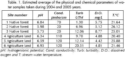
Stream pH ranged from 5.73 to 6.93 pH units, conductivity from 20 to 120 µmho/cm, turbidity from 1.30 to 20.51 n nephelometric turbidity units (NTU), dissolved oxygen from 4.42 to 8.77mg/L and temperature from 20.4oC to 26.12oC (Table 1). Average stream temperature in the native forest area was 21.64oC whilst being 25.88oC on agricultural land. Temperature values were significantly lower at sites 1, 2 and 3 than sites 4, 5 and 6; this was due to less protection upstream and high incident radiance at stream sites 4, 5 and 6.
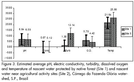
Soil movement-land-use was significantly correlated to physical and chemical analysis of water samples. Nascent water from the upstream watershed protected with native forest (site N.1), including hill-slope geometry and high elevation, was better compared to that from agricultural land (site N.5) (Figure 3).
Erosion depends on the soils nature and position in the relief. Such conditions, preventing land degradation and identifying such aspects will contribute towards determining the causes of specific soil degradation problems, improving effective actions for resolving agricultural and environmental problems.
Turbidity is a measure of cloudiness in water. It can be caused by soil erosion, waste discharge and runoff. High turbidity levels (site N.5) meant that water bodies had a denser amount of particles in the water. Dissolved oxygen is necessary for good water quality in a natural stream. However, dissolved oxygen (DO) level in water from a stream surrounded by agricultural activity dropped below 5.0 mg.L-1; it was observed that aquatic life was put under stress and no fish were observed.
Land-use had a significant impact on the streams parameters; the same has been observed by Caruso (2002). Conductivity, turbidity and temperature were higher in the streams near agricultural land, confirming the impact by human activity. Stream conductivity increased with an increase in ion concentration, this being attributed to erosion and micronutrients leaching from the soil (Caruso, 2002). Sampling data was used to provide a snapshot of conditions and for detecting the effects present in surface water (Hallock and Ehinger, 2003).
The water samples from all the sites indicated that the soil had been removed from hill-slopes in the study area, reflecting the dynamic impact of progressive tillage erosion upstream together with agricultural activity.
The complex relationship between the data evaluated and land-use suggested a need for management practices across the water-shed, reducing soil loss and groundwater pollution (Veseth and Miller, 1992). Conservation planning must be used in the area.
The results indicated the agricultural watersheds exposure to pollutants and/or toxicity. The real significance of such variation was not fully elucidated by the present investigation. However, the study of the water in conjunction with soil will contribute to a more comprehensive picture of environmental pollution in water-sheds, representing a useful reference point for future anthropogenic impact assessment in these areas.
Land restoration alongside the streams is an essential tool in the campaign to protect, improve, and increase protected areas; topographical characteristics have been influenced by agricultural activitys environmental impact.
These areas have retained their soil and hydrology characteristics, thereby allowing their natural functions to be reclaimed. Restoration is a complex process requiring planning, implementation, monitoring and management. It involves renewing natural and historical knowledge which has been lost or degraded and reclaiming their functions and values as vital ecosystems. Restoring our lost and degraded areas alongside the streams in their natural state is essential to ensure the health of the watershed being studied.
Conclusions
Characterising the watershed indicated that agricultural management activity affected stream water quality;
Watershed water quality upstream in a forested area was better than that in a deforested stream;
Turbidity was altered by human activity and analysing the data revealed significant differences in pH, electric conductivity, dissolved oxygen and temperature in upstream water protected by native forest and other land devoted to agricultural activity;
There was a predominant area of sheet and rill erosion on the main basin slope; such conditions led to land degradation;
Topographical characteristics have been influenced by agricultural activitys environmental impact. Land-use cover interpretation and the geographic information system used were an important tool for analysing the data; and
Monthly, seasonal or annual water quality monitoring and erosion evaluation (depending on the nature of the water resource and a watersheds dimensional characterisation) indicates the ecological health and water chemistry for providing overall assessment of water quality. Future work aimed at monitoring chemical, physical and biological parameters is necessary for better urban development and expanding agricultural areas for minimising the impact on ground and surface water-flow.
Acknowledgements
We would like to thank FAPESP, UNESP/FCAV for supporting this investigation. The study was financed by FAPESP and CNPq.
Bibliography
Arcova, F. C. S., Cicco, V. de., Qualidade da água de microbacias com diferentes usos do solo na região de Cunha., Estado de São Paulo, Scientia Florestalis, Vol.56, 1999, pp.125–134. [ Links ]
Braga, B.; Hespanhol, I.; Conejo, J. G. L., Introdução à engenharia ambiental., 2a ed. São Paulo, Pearson Prentice Hall, 2005, pp. 318 p. [ Links ]
Caruso, B., A survey comparing streams from forested and deforested watersheds to assess impact of land use change on the northeast shore of Lake Tanganyika., Nyanza, Annual Report, 2002. [ Links ]
Hallock, D., Ehinger, W., Quality Assurance Monitoring Plan., Stream ambient water quality monitoring, Environmental Assessment Program, Washington State Departament of Ecology, Olympia, Washington, 2003, pp.28. [ Links ]
Pissarra,T. C. T., Análise da bacia hidrográfica do Córrego Rico na sub-região de Jaboticabal., SP: Comparação entre imagens TM-Landsat 5 e fotografias aéreas verticais, 132f., tese apresentada à Universidade Estadual Paulista, Campus Jaboticabal, para obter a formação de Doutor, 2002. [ Links ]
Standard Methods for the Examination of Water and Wastewater., 19th edn, American Public Health Association/American Water Works Association/Water Environment Federation, Washington DC, USA, 1995, pp 1600. [ Links ]
Rodrigues, F. M., Avaliação do uso e ocupação do solo na microbacia hidrográfica do Córrego da Fazenda da Glória., Taquaritinga, S.P. Jaboticabal, tese apresentada à Universidade Estadual Paulista, Campus Jaboticabal, para obter a formação de Engenheiro Agrônomo, 2005. [ Links ]
Silva, L., Williams, D. D., Buffer zone versus whole catchment approaches to studying land use impact on river water quality., Water Research, Vol.35, No. 14, 2001, pp.3462-3472. [ Links ]
Strahler, A. N., Dimensional analysis applied to fluvially eroded landforms., Bull. Geol. Soc. Am., Vol. 69, 1958, pp. 279-300. [ Links ]
Tong, S. T. Y., Chen, W., Modelling the relationship between land use and surface water quality., In: Journal of Environmental Management, Vol. 66, 2002, pp.377-393. [ Links ]
Veseth, R. J., Miller, B. C., Precision farming variable cropland for profit and conservation: an introduction to variable management., Pullman: Washington State University, 1992. [ Links ]

