


Serviços Personalizados
Journal
Artigo
 texto em
  Espanhol (pdf)
 Artigo em XML
 Referências do artigo
 Enviar este artigo por email
Indicadores
-
 Citado por SciELO
 -
 Acessos
Links relacionados
-
 Citado por Google
 -
 Similares em
SciELO
Similares em
SciELO -
 Similares em Google
Compartilhar

 Permalink
Ingeniería e Investigación
versão impressa ISSN 0120-5609
Ing. Investig. v.31 n.1 Bogotá jan./abr. 2011
Hydroinformatics´ contributionto Amazonian water resources and ecosystemmanagement
Bell Manrique-Losada1, Jaime Alberto Echeverri-Arias2, Marlon Peláez-Rodríguez3
1System Engeneer and M.Sc. in System Engineering, Universidad Nacional de Colombia, Medellín. Research-professor, Faculty of Engineering, System Engineering, Universidad de Medellín. bmanrique@udem.edu.co
2 Mecanic Engineering and M.Sc. in System Engineering, Universidad Nacional de Colombia, Medellín. Research-professor, Faculty of Engineering, System Engineering, Universidad de Medellín. jaecheverri@udem.edu.co
3Biologist, M.Sc. and Ph.D. in Enviromental Engineering, Universidad de Sao Paulo. Research-professor, Faculty of Basic Science, Biology, Universidad de la Amazonia, Colombia. mpelaez@uniamazonia.edu.co
ABSTRACT
Significant progress has been made during recent yearsin applying information technologiesto water resource management from a multidisciplinary field called hydroinformatics; this can change the focus of environmental impact assessment and decision-making according to available environmental resources. This article presents an image retrieval system which uses the Universidad de la Amazonia’s (Colombia)Aquatic Ecosystem Quality and Preservation Research Group’s (CAPREA) digital image collection. Automaticpicture classification (having attributes relative to water colour, edges and flow type) is proposed which has beenbased onDinnertein's classification, adapted by the Universidad Nacional de Colombia'sHydrology and Meteorology Institute and Environment Studies in 2001.
Keywords: hydroinformatics, aquatic resource management, image retrieval, Amazonian aquatic ecosystem.
Received: December 20th 2009. Accepted: Feuary 7th 2011
Introduction
Water science and technology research teams require precise, up-dated information about particular resources, their distribution, use and geographical conditions to specify, characterise and sort them so as to advance action aimed at planning and regulating their use.
Watershed management thus has a oad impact. Progress in this area has altered the focus of environmental impact assessment and decision-making regarding ecological resources, supported by information technologies. The recently established anch called hydroinformatics forms part of a multidisciplinary approach applying advanced information technologies to water resource management.
This article presents a design for and implementation of a prototype water resources image retrieval and automatic classification system (IRS). The IRS used the Universidad de la Amazonia´s (Colombia) Aquatic Ecosystem Quality and Preservation Research Group´s (CAPREA) digital image collection.
This system led to automatic classification of a main type of Amazonian foothills and plains ecosystem, according to the classification scheme adapted by the Colombian Institute of Hydrology, Meteorology and Environmental Studies(IDEAM) and the Universidad Nacional de Colombia (Márquez, 2003).
It consisted of the initial loading of an image (digital photo) and the IRS then being supported by computational algorithms for measuring three water parameters/attributes: colour, edges and flow type.
Background and framework
Classifying aquatic ecosystems and water habitat in Colombia
The automatic classification system used the water ecosystem classification taken from Classification System for the Main Types of Non-Marine Amazonian Aquatic Ecosystem and Habitats in Colombia, adapted by Márquez (2003) from Dinnerstein et al., (1995), Welcomme (1979) and Márquez and Guillot (2001). Such proposed classification and zoning scheme for the Main Ecosystem Types (MET) has been divided into Main Habitat Types (MHT) for Colombian Amazonian aquatic ecosystems. This classification defines four MHT: lotic ecosystems, lentic ecosystems, wetlands and reservoirs.
Lotic system (rivers and other running-water systems).
This MET consist of streams, creeks and rivers characterised by constant, fast-flowing water; their longitudinal and altitudinal structure determines differences between high and low parts of the same water-body (varying as it descends). These ecosystems become more complex and more mature in lower areas than in the higher ones. A possible classification of common water bodies´ MET, based on their MHT, would be: rivers and mountain streams; black rivers and other streams on plains and white and clear plains´rivers.
Lentic system (lakes and other standing-water systems)
This MET involves slow-flowing water resources as opposed to running-water rivers. It mainly represents lakes and lagoons (natu -ral ponds) described as being relatively deepwater bodies; they have low renovation rates and usually a unidirectional flow through one or several affluent and effluent streams and other tributaries. Lakes and mountain lagoons (ponds), as well as swamps, may be amongst the MHT for these ecosystems.
Wetland
Wetlands include a varied group of ecosystems having a common feature: much of the time they are exposed to high-water saturation levels and even flooding. This kind of water body is not completely classified as a water ecosystem. They include swamps and marshes on large rivers´flood plains and also intertidal and other areas some how presenting regular or partial flooding.
Reservoir
These are artificial water bodies formed by river dams. They are considered different MET because they consist of intermediate ecosystems between running-water (rivers) and lentic water (lakes). Their water flows renew much more slowly than the former but much faster than the latter. Two MHT can be distinguished: cold and temperate mountain reservoirs and warm reservoirs.
Hydroinformatics and cyberinfrastructure
Hydroinformatics is a transdiciplinary field of study combining technological, sociological, human and environmental interests (Oegón and Fragala, 2003) and includes an ethical perspective. It also includes information and communication technologies (ICT) applied to aquatic environment and water resource management issues (GRH, 2010). It aims at providing engineers and administrators in the field with decision-making tools via available ICT so that they can face the increasingly great challenges and thereby guarantee sustainable aquatic ecosystem and water resource management for coming generations. Hydroinformatics uses simulation models and ICT to solve problems in hydraulics, hydrology and environmental engineering to ensure better use of aquatic resource-based systems. River basin management, flooding and urban and littoral aquatic systems represent the main application areas.
The term cyberinfrastructure describes a new research environment supporting data acquisition, storage, management, integration, mining and advanced visualisation as well as other Internet processing services (Bemet, 2007). Cyberinfrastructure is a technological solution for efficiently connecting data, computers and people for providing new theories and scientific knowledge.
Image retrieval systems (IRS)
IRS are related to efficient storage and register retrieval. They areuseful if they can retrieve acceptable coincidences regarding some real-time characteristics. Apart from key words assigned by humans, IRS can use images´visual content, such as indices (colour, texture and shape). A technique for filling the gap between textual and pictorial descriptions for exploring information in documents is taken from information retrieval called ´latent’ semantic analysis (Obeid et al., 2001). First, a document-picturebased corpus is formed; then, the dictionary is correlated with the features derived from the images, through singular value decomposition. The system uses intermediate characteristics (semantic – low level- and pictorial – high level) to sort each image in the collection.
Several content-based IRS include a search for features such as image object colour, texture and shape. Most are general purpose systems and are used in practical applications in just a few studies. Some of the most interesting are QBIC (Ashley et al., 1995) and MARS (Hirata and Kato, 1992). A summary of such system techniques can be found in Rui et al.,(1999).
Digital collections are obtained when digital information resources are grouped or gathered; when these collections are organised into a descriptive system by means of any type of cataloguing and are associated with search easiness and use of information, then information retrieval and digital liaries are obtained (Borgman, 1999). The latest advances in this type of technology demand powerful processing tools. Different techniques working with traditional systems have involved alphanumeric registers since they can be ordered, indexed and found by pattern matches. However, in scientific applications, image information content is not explicit, therefore not being suitable for its direct indexation, classification and retrieval. Large collections of images are being created in other areas such as trade, government, the academic world and medicine. However, there are still marked needs in areas like biology, geology, ecology and the aquatic ecosystem area in which the use of key words, indexation or just manual search are the only means of search. However, content-based search is rather useful in databases, digital liaries and IRS.
Water resource management background
Various proposals supporting aquatic resource management and planning from different areas of work can be found in the pertinent literature. Integrated computer systems made one of the first contributions in civil engineering in designing, operating and maintaining complex engineering systems, such as STRUDL, COGO, PROJECT, and in macro-projects as man and computer (MAC) and integrated civil engineering systems (ICES) (Roos, 1965). Other contributions have been made in the field of ´infrastructure` with advances in hardware, software and communication technologies applying computational modelling, sensing systems and hardware for lithography (O´Kane and Martin, 2000).
Internet technologies, Intranet, Extranet and WAP (O´Kaneand Martin, 2000), are making fast advances and have implications in the world of water and therefore in society. Some of them have been related to hydrodynamic modelling and controlling river basin flow, supporting decision-making systems for when floods occur, optimising reservoir control for hydrographic watersheds, using geographical information systems (GIS) and Internet technologies for resolving aquatic resource management problems, hydrodynamic models of seas and modelling water-supply networks. Environmental and water management and planning need the creation of systems which are accessible on the Web by water resource administrators, planners, engineers, users and the public in general; this leads to setting up a network, management policies and intervention which are healthy, practical and contextualised within the actual needs of the environment. Such hydroinformatics´ tools´social and cultural dimension thus become a strong research area (Abbott and Vojinovic, 2009).
This work´s final objective was to count on a web system which, apart from offering information on aquatic ecosystems, their location and characterisation, would lead to constructing a network around actors working in this area and creating management, intervention, diffusion and healthy resource use policies.
Results
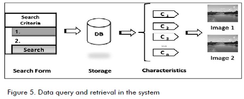
Analysing and designing IRS
The IRS prototype was designed by CAPREA at the Universidad de la Amazonia (Caquetá, Colombia) using the digital image collection for both foothills and plain in the Amazonian region. The IRS allows storage, classification and retrieval of water images. The digital collection was built by digitalising analogue photos, diagrams and plans and new images were captured from the Northern Amazonian areas of Brazil and Peru.
The steps involved in IRS development are presented; the query planning model was taken from the methodology proposed by Manrique (2006)and query types defined.
Software system analysis and design allows a stakeholder to understand and simplify information processing within a specific context and is expressed by means of design patterns. These patterns represent the domain´s conceptual and dynamic structure.
A set of models was designed defining aspects regarding the structure, process and architecture for information about Amazonian water resources for final IRS construction. The IRS was developed using the rational unified process software development methodology, supported in Unified Modeling Language (OMG, 2008). Figures 1 and 2 show IRS pattern, as in use case model and sequence model.
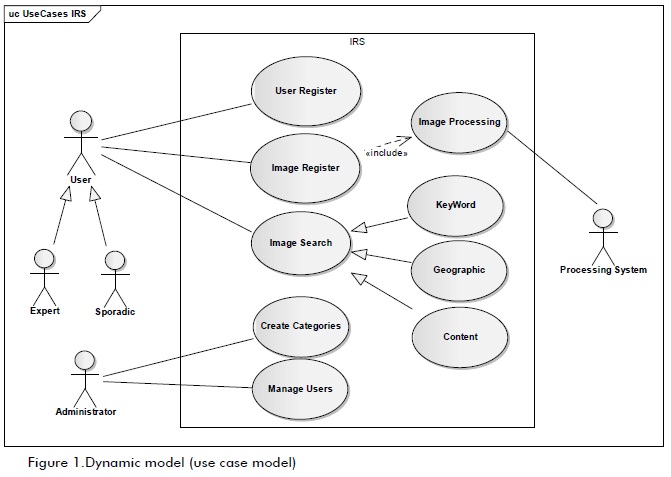
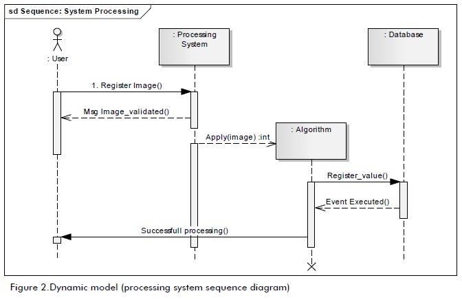
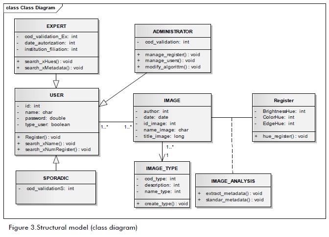
Figure 3 shows the structural model (class diagram) for the proposed IRS, structurally and statically specifying how objects and components are related. The model shows identified domain objects and defines an architectonical style used as the water IRS skeleton. IRS modelling can be found in the 11thVolume of the Universidad de Medellín´s Engineering Journal (Manrique et al., 2008).
imagine analysis, procesing and classification
Some sciences are implementing computational tools called ′intelligents systems′ (Olarte et al.,2003) algorithms for classified images being one of them. Different algorithms were applied in this work to obtain associated characteristics; for example:
-Binarisation: binarising an image consists of extracting lightness (ightness, density) as a feature from the image. The first step consists of converting the image to grey scale, fixing a value (threshold), converting all higher values to white pixels and the other values to black pixels. This method facilitates searching the surroundings and consequently determines the type of waterbed and classification.
-Edge detection: (Oramet al., 2008). This algorithm enables information to be extracted, such as an object´s form and size. This method allows ROCs or granular elements to be detected in the image. The prototype detects the type of water resource edge and then generates the stream type.
-Improvement algorithms: These are filters for smoothing, sharpening and detecting edges and removing other features which may be stored or implied in the images by implementing other algorithms (Echeverri et al., 2008). Through calculates the value for a given point or pixel from the value of its neighbours. The system thus facilitates the task of classifying water colour, colour inversion, grey scale images and histogram extraction. They forma user´s search features.
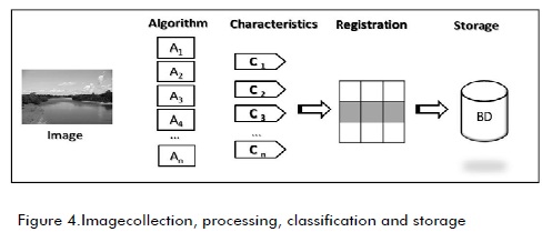
The system allows other types of classification, but does not relate to algorithm application. For example: classifying geographic coordinates. Geographic coordinates lead to finding a place (within the water resource) and classifying it by its region (department/ municipality) and features associated with the image: author, format, size, date (as appear in Picture 4).The algorithms for each image provide associated characteristics for creating a register which is stored in the database.
Implementing IRS
The IRS was implemented in C# programming language (Sharp) in a web application framework (ASP.NET). SQL server (database management system) was used for creating the database. Each image was indexed, supported by the parameters generated by automatic classification or manually registered by the user to obtain relevant results quickly when processing the searches.
Conclusions and future work
This proposal resulted from a research team´s interdisciplinary work and constitutes a reference point for starting to understand the dynamics and importance of Amazonian aquatic ecosystems their conditions, fragility and the urgent need to preserve their essential ecology since their great natural (undervalued and little known) productivity faces threats, mainly related to inadequate anthropic activities.
The basis of pictorial knowledge about such living resources consists of the contribution made by this investigation, additionally producing educational and academic processes and consensus with local communities for new working strategies and technological contributions in these research areas.
The IRS prototype has been set up in a double-access server to permit edition, consultation and distribution of images regarding this type of resource in a practical and economic way. It facilitates the preservation of pictorial information and other important aspects of ecosystem conservation and knowledge and diffusion of materials considered essential for researchers (biologists, ecologists, environmentalists and zoologists) and determines Amazonian aquatic ecosystems´ ecological condition.
This work has led to research into ecosystem characterisation (threats, current state causes, anthropic activity consequences, animal and plant varieties, hydro-biological inventories). Algorithms are also being tested for automatically generating additional attributes.
References
Abbott, M., Vojinovic, Z., Applications of numerical modelling in hydroinformatic., Journal of Hydroinformatics, Vol. 11, No. 3, 2009, pp. 308-319. [ Links ]
Ashley J., Flickner M., Hafner J., Lee D., Niblack W., Petkovic D., The Query By Image Content (QBIC) System., ACM SIGMOD International Conference on Management of Data, San José, 1995, pp. 475. [ Links ]
Bement, A., Cyberinfrastructure: The Second Revolution., Chronicle of Higher Education, Vol. 53, Issue 18, 2007, pp. 5. [ Links ]
Borgman, C. L., What are digital libraries. Competing visions., Information Processing and Management 35, 1999, pp. 227 -243. [ Links ]
Dinnerstein, E., Olson, D. M., Graham, D. J., Webster, A. L. Primm, S. A., Bookbinder, M. P., Ledec, G., Una evaluación del estado de conservación de las ecorregiones terrestres de América Latina y el Caribe., Fondo Mundial para la conservación de la naturaleza y Banco Mundial (ed.), Washington, 1995, pp. 133-135. [ Links ]
Echeverri, J. A., Bravo, A., Manrique, B., Eliminación de ruido impulsivo por medio de la utilización de funciones de base radial., Memorias del XIII Simposio de Tratamiento de Señales, Imágenes y Visión Artificial, STSIVA 2008, Bucaramanga, 2008, pp. 147-150. [ Links ]
GRH., Potenciación del Laboratorio de Hidroinformática para Afrontar los Retos Europeos., Grupo de I+D Gestión de Recursos Hídricos, Universidad Politécnica de Cartagena, 2010, Disponible en: http://www.upct.es/~agua/laboratorio.html [Acceso Mayo 2010] [ Links ].
Hirata, K., Kato, T., Query by Visual Example., Proceedings of the 3rd International Conference on Extending Database Technology: Advances in Database Technology., 1992, pp. 56-71. [ Links ]
Manrique, B., Modelo de Planificación de Consultas con Manejo de Calidad de la Información en Sistemas de Integración de Información., tesis presentada a la Universidad Nacional de Colombia - Medellín, Colombia, para optar al título de M.Sc. en Ingeniería, 2006. [ Links ]
Manrique, B., Echeverri, J. A., Moreno, F. J., Modelamiento de un sistema de recuperación de imágenes de recursos acuáticos, basado en contenido y calidad de la información., Revista de Ingenierías, Vol. 7, No. 13, 2008, pp. 97-109. [ Links ]
Márquez, G., Ecosistemas de Colombia., Lección Virtual Unal.,Universidad Nacional de Colombia, Bogotá, 2003. [ Links ]
Márquez, G., Guillot, G., Ecología y efecto ambiental de embalses: aproximación con casos colombianos., Vol. 1, IDEA - Universidad Nacional de Colombia, Medellín, 2001, pp. 39-50. [ Links ]
Obeid, M., Jedynak, B., Daoudi, M., Image Indexing & Retrieval Using Intermediate Features., Proceedings of the ninth ACM international conference on Multimedia, Otawa, 2001, 531-533. [ Links ]
Obregón, N., Fragala, F., Sistemas Inteligentes, Ingeniería e Hidroinformática., Revista Ciencia e Ingeniería Neogranadina, Vol. 1, No. 13, 2003, pp. 71-82. [ Links ]
O´Kane, J. P., Martin, J., The Blue City of the Future Hydroinformatic.Tools for the Management of its Waters., Journal of Hydroinformatics, National University of Ireland, Cork, 2000, pp. 71-77. [ Links ]
Olarte, R., Obregón, N., Rengifo, P., Algoritmos Evolutivos e Hidroinformática., Memorias Seminario Internacional La hidroinformática en la Gestión Integrada de los Recurso Hídricos, Cali, 2003, Disponible en: http://www.bvsde.paho.org/bvsacd/agua2003/algo.pdf [Acceso: Mayo 2008] [ Links ]
OMG., UML 2.0 Superestructure Specification., Disponible en: http://www.omg.org/uml/ [ultimo acceso: May 2008] [ Links ].
Oram, J., McWilliams, J., Stolzenbach, K., Gradient-based edge detection and feature classification of seasurface images of the southern California Bight., Remote Sensing of Environment.,International Council for the Exploration of the Sea, Vol 112, Issue 5, 2008, pp. 2397-2415. [ Links ]
Roos, D., An integrated computer system for engineering problem solving., Proceedings AFIPS Joint Computer Conferences,1965, pp. 423-433. [ Links ]
Rui, Y., Huang, T. S., Chang, S., Image Retrieval: Current Techniques, Promising Directions, and Open Issues., Journal of Visual Communications and Image Representation 10, 1999, pp. 39-62. [ Links ]
Welcomme, R. L., Fisheries Ecology of Flood Plain Rivers. Longman (ed.), New York., 1979, pp. 280-284. [ Links ]

