


Serviços Personalizados
Journal
Artigo
 texto em
  Espanhol (pdf)
 Artigo em XML
 Referências do artigo
 Enviar este artigo por email
Indicadores
-
 Citado por SciELO
 -
 Acessos
Links relacionados
-
 Citado por Google
 -
 Similares em
SciELO
Similares em
SciELO -
 Similares em Google
Compartilhar

 Permalink
Ingeniería e Investigación
versão impressa ISSN 0120-5609
Ing. Investig. v.31 n.3 Bogotá set./dez. 2011
Rating curve estimation using Envisat virtual stations on the main Orinoco river
Juan León 1, Frederique Seyler2, Astrid Puerta3
1 Ph.D., Universidad de Toulouse. Professor, Universidad Nacional de Colombia - Palmira. jgleonh@gmail.com
2 Ph.D., Universidad de Paris. Institute de Recherche pour le Developpement -IRD., France. frederique.seyler@ird.fr
3 Environmental Engineering, Master Student in Environmental Engineering, Universidad Nacional de Colombia-Palmira. astridpuertam@gmail.com
ABSTRACT
Rating curve estimation (height-stream relation) made by hydrometric stations representing cross-sections of a river is one of hydrometrics' fundamental tasks due to the fact that it leads to deducing a river's average daily flow on that particular section. This information is fundamental in any attempt at hydrological modelling. However, the number of hydrological control stations monitoring large hy-drological basins has been reduced worldwide. Space hydrology studies during the last five years have shown that satellite radar altimetry means that hydrological monitoring networks' available information can be densified due to the introduction of so-called virtual stations and the joint use of such information along with in-situ measured flow records for estimating expenditure curves at these stations.
This study presents the rating curves for 4 Envisat virtual stations located on the main stream of the Orinoco River. Virtual stations' flows were estimated by using the Muskin-gum-Cunge 1D model. There was less than 1% error between measured and estimated flows. The methodology led to reducing average zero flow depth; in this case, it led to depths ranging from 11 to 20 meters being found along the 130 km of the Orinoco River represented by the virtual stations being considered.
Keywords: biogas, oxygen enrichment, greenhouse gas, combustion property.
Received: March 5th 2010 Accepted: November 24th 2010
Introduction
Calibration or rating curves are hydrological tools which highlight the existing relationship between water level and the flow rate corresponding to that height for a given section of a river. Rating curves which are usually expressed as a power law are used to reduce average daily flows from daily water levels' on-site records taken from each station's gauges. The calibrated relationship between both variables is deducted from pairs of stage-discharge data obtained by gauging (WMO, 1994). The accuracy of the estimated daily flows is related to the quality of this ratio obtained for a particular section, in turn, depending on the number of gaugings made. However, the number of hydrometrical stations monitoring a basin's hydrological behaviour worldwide has become reduced (Vörösmarty et al., 1999; Espinoza, 2009).
This problem is even more evident in developing countries where hydrometric networks' management agencies' lack of budget hampers the installation of new stations and affects operating station maintenance and management. This then suggests the need for new tools and technologies to support continental surface waters' ongoing monitoring systems by providing support and continuation for measurements recorded in-situ, in addition to seeking densification of such control networks.
Several studies (Brooks, 1982; Morris and Gill, 1994; Mercier et al., 2002; Frappart et al., 2006; Crétaux and Birkett, 2006; Leon et al., 2009a) have shown the advantages of satellite radar altimetry in measuring changes in continental water levels. Such studies, besides presenting a detailed literature review regarding this technology, have shown how its application not only has to do with precision linked to records but also with its ability to measure instantaneous levels of water bodies, having quite acceptable spatial and time resolutions. These measurements lead to defining what are known as virtual stations, this being any intersection between satellite scanning and a continental water plan on which the recorded data infer a time series representing surface water level variations (León et al., 2008).
Altimetry for Colombia (ALTICO) has been particularly developed for this country (León et al., 2009b). It is a database containing 548 ENVISAT virtual stations concerning Colombia's entire hydrological network, including major and minor rivers, lakes, dams and flood areas.
About three years ago, Leon et al., (2006) developed and validated a methodology for estimating Envisat and Topex/Poseidon virtual stations' expenditure curves. Such methodology allows relating time series of water levels recorded by a satellite and measured or estimated flows in the virtual stations, in other words meaning estimating rating curves at these virtual stations.
This study was aimed at applying Leon et al.'s 2006 methodology for obtaining cost curves regarding some Envisat virtual stations reported by Leon et al., (In revision) in the Colombian Orinoco basin.
Material and method
Study area
The Orinoco basin has an area of around 1,015,000 km2, of which about 640,000 km2 belong to Venezuela (63% of the lower Orinoco basin). Surface runoff drains from the Andes, the upper and middle Orinoco basins in Colombia (Figure 1). The Orinoco River's 1,783 km length makes it the second largest river in South-America after the Amazon and the third longest in the world after the Congo. The Orinoco River and its tributaries represent the largest natural surface drainage system in eastern Colombia, in an area known as the Eastern Plains. The most important tributaries of the area are the Meta, Guaviare, Inirida and Vichada Rivers. Their overall contribution has been estimated at around 15,000 m3/s, accounting for nearly 50% of the Orinoco River's total flow to the Atlantic Ocean.
In-situ and altimetric information
The virtual stations used in this study were drawn from ALTICO, a database developed by the Universidad Nacional de Colombia in Palmira, containing about 550 Envisat virtual stations located on major Colombian waterways, lakes, dams and flood areas (Leon et al., 2009b). These virtual stations show time series regarding the variation in free surface water levels for a period between 2002 (mission start date) and 2008 (the date for which records were updated for the currently operating mission), measurement records being taken every 35 days (Leon et al., 2008).
ALTICO, developed entirely in Microsoft Access, has been designed to have a single tabular structure organising all the available virtual stations in Colombia, giving the following data for each one: station number, body of water to which it belongs to (river, lake, flood area, swamp ..), satellite trace number, station name, geographical coordinates, links for quick viewing of the station, link to access the data forming the time series and link to visualising the station on Google Earth.
ALTICO stores data for 120 virtual stations in the Orinoco basin, 78 of which are located on the river basin's main channels, 18 on the Guaviare River, 17 on the Meta River, 15 on the Inirida River, 9 on the Orinoco River, 8 on the Vichada River, 6 on the Arauca River and 5 on the Casanare River (Leon et al., in review). These stations are presented as white identifiers in Figure 1. The methodology proposed by Leon et al., (2006) was applied to assess altimetry series' level of precision which involved estimating the root mean square (RMS) between the virtual series and nearest in-situ series. Logically, this process is only valid when the virtual station is on an in-situ station or, alternatively, at a short distance within a section which is not affected by abrupt hydraulic changes (Leon et al., 2008). This method led to validating 20 virtual stations on the Orinoco basin, having RMS values close to 45 ± 14cm (Leon et al., in review)
Meanwhile, in-situ information was provided by the Institute of Hydrology and Environmental Meteorology and Environmental Studies in Colombia (IDEAM). Figure 1 shows the 64 hydrometric monitoring stations available for the study area (dark gray points). However, only 34 of the 64 stations are recording daily water levels regarding the basin's main channels. Only 22 of them have average daily flow records for 2002 and 2003. No stations have complete records of flows between 2002 and 2008, the period for which updated records are available at Envisat. Table 1 summarises the availability of information regarding the Orinoco Basin's main channels.
This study then focused on 4 of the 9 stations present on the Orinoco River: 493Orinoco04, 493Orinoco01, 622Orinoco04 and 622Orinoco03. The reason for selecting these stations was because they are located between two in-situ hydrometric stations which have complete records of levels and flows between 2002 and 2003, this being which they represent. The total section considered was about 130 km of the Orinoco's main channel. Table 2 summarises the characteristics regarding space distribution of the virtual and in-situ stations on the section being considered.
Flow estimation
The flows in the virtual stations were estimated by applying the Mskingum-Cunge (MC) traffic model, this being an approach based on a quasi-dynamic approximation of wave propagation (Ponce et al., 1996). The MC model (Cunge, 1969) is in fact a version that fits the Muskingum classic model, where the wellknown parameters X and K are derived from the hydraulic characteristics of a section being considered: slope in a particular section, channel width, wave speed and section length (Ponce et al., 1996).
Basically, applying the model consisted of propagating daily middle flows known for an upstream station towards a downstream station, by assuming that the propagation of wave dynamics was based on that section's hydraulic characteristics. This propagation could be done on one or more downstream sections for which the aforementioned hydraulic characteristics would already be known. For validation purposes, it was necessary to count on an average daily flow downstream to calculate estimated flow during propagation and flows measured in-situ. Leon et al. (2006) have made a complete revision of the MC model and presented its detailed application to large channels for the flow estimation by virtual Envisat stations in the Amazon Basin.
Estimating the error between estimated flow rate and measured flow was done by applying the ratio shown in Equation 1. This ratio considers mean absolute error based on the flow measured in-situ downstream of the station.
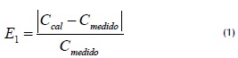
Ccal was estimated flow using the MC model, Cmeasured was daily flow rate known at the in-situ station. The MC model for the station in Puerto Nariño (upstream station) to the Roncador station (station downstream) was applied for this study, spreading flows over the virtual intermediate stations listed in Table 2.
Estimated rating curves
Due to the short period regarding available in-situ flow data (2002-2003) and that altimetry measurements were taken every 35 days, it was necessary to make a temporal interpolation for deriving daily mean water levels regarding the altimetric series to obtain pairs of height/flow data for deriving a more accurate rating curve for each virtual station. An interpolation of temporal series methodology proposed by Roux et al., (2008) was thus applied.
Series of daily water levels regarding space and flows estimated at virtual stations led to deducing these sections' rating curves (Leon et al. 2006). In effect, expressed as a power law, a rating curve can be represented by equation 2 (Rantz et al., 1982).
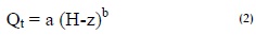
where Q was flow at time t and (Hz) was the depth of zero flow channel control section at time t. H was the height of the free surface of water measured by the satellite and continental referenced GRACE geoids and z was the height of the flow taken over the same reference. Coefficients a and b were specific to each section and represented their hydraulic characteristics (Rantz et al., 1982).
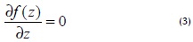
The methodology proposed by Leon et al., (2006) was used for determining the depth of zero flow (Hz). This method consists of minimising root mean square error (RMSE) between the flow estimated by the hydrological model and a flow rate estimated by Equation 2: for a given value of z, coefficients a and b were estimated by linear regression (Ln (Q), Ln (Hz)). By exploring a range of possibilities of z it was possible to construct RMSE (z) = f (z). All the possible range of values which might have had z was explored in 0.01 m increments. The value of z that best represented the altitude of zero effective flow could be expressed as shown in Equation 3.
Results and Discussion
Virtual stations' water level time series
The altimetric series for virtual stations presented in Table 2 were subjected to interpolation between 2002 and 2003, following the methodology proposed by Roux et al., (2008) to obtain a daily series of water levels. Figure 2a shows water levels time series at a virtual station obtained from ALTICO. This example refers to the 622Orinoco03 series from 2002 to 2008. Figure 2b is a sample of the result of the interpolation carried out to obtain mean daily water levels between 2002 and 2003.
Virtual stations' flow estimation
The MC model was used for estimating virtual stations' average daily flows. Table 3 summarises the results of applying the model between the Puerto Nariño and Roncador stations for deriving flows in the four virtual stations included in the study.
Table 3 shows that in the 130 km of the Orinoco River considered in this study there was no significant river sub-section influence regarding other rivers flowing into this piece of river, thereby facilitating the application of the model and significantly decreasing average errors regarding estimating flows in virtual stations. At the end of transit, RMSE below 1% were found between virtual flow rate and in situ measured flow rate. This result led to concluding that the virtual stations' quality regarding estimated flow series was good.
Calibration curves of virtual stations and depth of zero flow.
With a daily series of water levels recorded from space and flow obtained from a hydrodynamic model it was possible to deduce the equivalent rating curves and flow depths by applying the proposed methodology. Figure 3 shows the rating curves obtained for the 4 virtual stations considered in this study, along with the equations governing these sections and the average depth of zero flow for each of them.
It was possible to reconstruct the average daily flows for virtual stations from 2002 to 2008 from these ratios and thereafter the dates on which altimetric data was available from the Envisat mission or its successor. Basically, these relationships will allow estimating flows for such sections from daily water level records from space.
Regarding the zero flow depths found, field work is fundamental as it leads to validating such information. However, the values found were closely adjusted to reality in relation to the appraisals made at the Puerto Nariño and Roncador stations where, on average, channel depths ranged from 12 ± 17 ± 4m and 4m, respectively.
Conclusions
This study confirmed radar altimetry's advantages and its use regarding inland waters. The information regarding IDEAM's in-situ average daily flows and those from the Envisat mission concerning virtual stations' water levels led to the hydraulic characterisation of the sections in the same way as it is traditionally done, i.e. by defining rating curves for estimating daily flows from water levels and where the coefficients governing mathematical relationships contain information about the hydraulic characteristics of the section that they represent.
Four rating curves for ENVISAT virtual stations have been estimated, located between the Puerto Nariño and Roncador hydro-metric stations, representing 130 km of the Orinoco River's main stream. The RMSE minimisation method proposed by Leon et al., (2006) led to deducing the zero flow depth of four sections varying 16.7 ± 4.3 m on average, which was consistent with the appraisals made at the aforementioned in-situ stations.
This methodology will continue being applied for studies in the Orinoco Basin and other Colombian basins defined from ALTICO, where a traffic model can be set up for estimating flows in virtual stations. Rating curves will be made for the Meta, Arauca and Guaviare rivers. This information will begin to be used by institutions such as the IDEAM with two basic goals: hydrological monitoring network densification and complementing hydromet-ric stations' records. Future studies will document such additional applications.
Acknowledgements
The authors would like to thank researchers from the IRD's HY-BAM programme for the scientific and technical collaboration provided by their LEGOS AND LMTG laboratories.
Agradecimientos
Los autores agradecen la colaboración científica y técnica aportada por los investigadores del Programa HYBAM del IRD por medio de sus laboratorios Legos y LMTG.
References
Brooks, R.L., Lake elevation from satellite radar altimetry from a validation area in Canada., Reporte, Geosci. Res. 1982.
Crétaux, J.F., Birkett C., Lake studies from satellite radar altimetry Altimétrie satellitaire sur les lacs., Comptes Rendus Geo-sciences. Volume 338, 2006, Issues 14-15,
Cunge, J.A., On the subject of a flood propagation computation method (Muskingum method)., Hydraul. Res. 7 (2), 1969, 205-230.
Espinoza, J.C., Guyot, J-L., Ronchail, J., Cochonneau, G., Filizola, N., Fraizy, P., Labat, D., De Oliveira, E., Ordoñez, J,J., Vauchel, P., Contrasting regional discharge evolutions in the Amazon basin (1974-2004)., Journal of Hydrology, 2009, 375, 3-4. 297-311.
Frappart, F., Hydrologie spatiale :Développement d'applications pour l'utilisation de la télédétection sur les grands bassins fluviaux., Tesis doctoral de la Univ. Toulouse III-Paul Sabatier, 30/11/2006, 283p.
Leon J.G., Calmant S, Seyler F., Bonnet M.P., Cauhopé M., Rating curves and average water depth estimation at the upper Rio Negro from altimetric spatial data and calculated remote discharges., Journal of Hydrology, 2006, 328, 481-496.
Leon, J.G., Rubiano, J., Vargas, V., Series temporales de niveles de agua en estaciones virtuales de la Cuenca Amazónica a partir de altimetría radar por satélite., Ingeniería e Investigación. Vol 29, No. 1. 2009a., pp 109-114p.
Leon. J.G., Navarro, C., Seyler, F. Monitoreo de la hidrografía colombiana mediante la implementación de estaciones virtuales ENVISAT. Agua 2009. CINARA. Universidad del Valle. Colombia - Cali. Octubre de 2009.
Leon, J.G., Domínguez, E., Duque, G., Avances más Recientes Sobre la Aplicación de la Altimetría Radar por Satélite en Hidrología. Ingeniería e Investigación. Vol. 28 No. 3, 2008, pp 126 - 131.
León, J.G., Rubiano, J., Navarro, C.E., Estaciones hidrométricas virtuales ENVISAT en la cuenca alta y media del rio Orinoco. Ingeniería e Investigación, Universidad Nacional de Colombia, 2010 (Under review)
Mercier, F., Cazenave, A., y Maheu C., Interannual lake level fluctuations (1993-1999) in Africa from Topex/Poseidon: connections with ocean-atmosphere interactions over the Indian ocean, Global and Planetary Changes, 2002, 32, pp 141-163.
Morris, C.S., Gill,S.K., Variation of great lakes waters from Geosat altimetry., Water Resour, 1994, Res., 30:1009-1017.
Organización Meteorológica Mundial., Guía de prácticas hidrológicas. Quinta edición, OMM No 168., 1994, pp. 147-173.
Ponce, V.M., Lohani, A., Scheyhing, C., Analytical verification of Muskingum-Cunge routing., J. Hydrol. 174, 1996, pp 235- 241.
Rantz, S.E., Measurement and computation of streamflow., Measurement of Stage and Discharge, US Geological Survey Water Supply Paper, vol. 1, 1982, p. 284.
Roux, E., Cauhope, M., Bonnet, M.-P., Calmant, S., Vauchel, P., Seyler, F., Daily water stage estimated from satellite altimetric data for large river basin monitoring. Hydrol. Sci. J. 53(1), 2008. pp 81-99.
Vörösmarty, C., Birkett, C., Dingman, L., Lettenmaier, D.P., Kim, Y., Rodriguez, E., Emmitt, G., HYDRA-SAT, HYDRlogical Altimetry SATellite, NASA Post-2002 Land Surface Hydrology Mission Component for Surface Water Monitoring, report from the NASA Post-2002. Land Surface Hydrology Planning Workshop, Irvine, CA, April 12-14th, 1999.
Brooks, R.L., Lake elevation from satellite radar altimetry from a validation area in Canada., Reporte, Geosci. Res. 1982. [ Links ]
Crétaux, J.F., Birkett C., Lake studies from satellite radar altimetry Altimétrie satellitaire sur les lacs., Comptes Rendus Geo-sciences. Volume 338, 2006, Issues 14-15, [ Links ]
Cunge, J.A., On the subject of a flood propagation computation method (Muskingum method)., Hydraul. Res. 7 (2), 1969, 205-230. [ Links ]
Espinoza, J.C., Guyot, J-L., Ronchail, J., Cochonneau, G., Filizola, N., Fraizy, P., Labat, D., De Oliveira, E., Ordoñez, J,J., Vauchel, P., Contrasting regional discharge evolutions in the Amazon basin (1974-2004)., Journal of Hydrology, 2009, 375, 3-4. 297-311. [ Links ]
Frappart, F., Hydrologie spatiale :Développement d'applications pour l'utilisation de la télédétection sur les grands bassins fluviaux., Tesis doctoral de la Univ. Toulouse III-Paul Sabatier, 30/11/2006, 283p. [ Links ]
Leon J.G., Calmant S, Seyler F., Bonnet M.P., Cauhopé M., Rating curves and average water depth estimation at the upper Rio Negro from altimetric spatial data and calculated remote discharges., Journal of Hydrology, 2006, 328, 481-496. [ Links ]
Leon, J.G., Rubiano, J., Vargas, V., Series temporales de niveles de agua en estaciones virtuales de la Cuenca Amazónica a partir de altimetría radar por satélite., Ingeniería e Investigación. Vol 29, No. 1. 2009a., pp 109-114p. [ Links ]
Leon. J.G., Navarro, C., Seyler, F. Monitoreo de la hidrografía colombiana mediante la implementación de estaciones virtuales ENVISAT. Agua 2009. CINARA. Universidad del Valle. Colombia - Cali. Octubre de 2009. [ Links ]
Leon, J.G., Domínguez, E., Duque, G., Avances más Recientes Sobre la Aplicación de la Altimetría Radar por Satélite en Hidrología. Ingeniería e Investigación. Vol. 28 No. 3, 2008, pp 126 - 131. [ Links ]
León, J.G., Rubiano, J., Navarro, C.E., Estaciones hidrométricas virtuales ENVISAT en la cuenca alta y media del rio Orinoco. Ingeniería e Investigación, Universidad Nacional de Colombia, 2010 (Under review) [ Links ]
Mercier, F., Cazenave, A., y Maheu C., Interannual lake level fluctuations (1993-1999) in Africa from Topex/Poseidon: connections with ocean-atmosphere interactions over the Indian ocean, Global and Planetary Changes, 2002, 32, pp 141-163. [ Links ]
Morris, C.S., Gill,S.K., Variation of great lakes waters from Geosat altimetry., Water Resour, 1994, Res., 30:1009-1017. [ Links ]
Organización Meteorológica Mundial., Guía de prácticas hidrológicas. Quinta edición, OMM No 168., 1994, pp. 147-173. [ Links ]
Ponce, V.M., Lohani, A., Scheyhing, C., Analytical verification of Muskingum-Cunge routing., J. Hydrol. 174, 1996, pp 235- 241. [ Links ]
Rantz, S.E., Measurement and computation of streamflow., Measurement of Stage and Discharge, US Geological Survey Water Supply Paper, vol. 1, 1982, p. 284. [ Links ]
Roux, E., Cauhope, M., Bonnet, M.-P., Calmant, S., Vauchel, P., Seyler, F., Daily water stage estimated from satellite altimetric data for large river basin monitoring. Hydrol. Sci. J. 53(1), 2008. pp 81-99. [ Links ]
Vörösmarty, C., Birkett, C., Dingman, L., Lettenmaier, D.P., Kim, Y., Rodriguez, E., Emmitt, G., HYDRA-SAT, HYDRlogical Altimetry SATellite, NASA Post-2002 Land Surface Hydrology Mission Component for Surface Water Monitoring, report from the NASA Post-2002. Land Surface Hydrology Planning Workshop, Irvine, CA, April 12-14th, 1999. [ Links ]

