


Services on Demand
Journal
Article
 English (pdf)
 Article in xml format
 Article references
 Send this article by e-mail
Indicators
-
 Cited by SciELO
 -
 Access statistics
Related links
-
 Cited by Google
 -
 Similars in
SciELO
Similars in
SciELO -
 Similars in Google
Share

 Permalink
Ingeniería e Investigación
Print version ISSN 0120-5609
Ing. Investig. vol.32 no.1 Bogotá Jan./Apr. 2012
A methodology for landfill location using geographic information systems: a Colombian regional case
Metodología para la localización de rellenos sanitarios mediante sistemas de información geográfica. Un caso regional colombiano
Carlos Alfonso Zafra Mejía1, Franklin Andrés Mendoza Castañeda2, Paula Alejandra Montoya Varela3
1 Civil Engineer and Environmental Engineering Specialist, Universidad Industrial de Santander, Colombia. M.Sc. in Environmental and Sanitary Engineering, PhD. in Environmental Engineering, Universidad de Cantabria, Spain. Director, Grupo de Investigación en Ingeniería Ambiental-GIIAUD, Facultad de Medio Ambiente y Recursos Naturales, Universidad Distrital F.J.C., Bogotá. E-mail: czafra@udistrital.edu.co.
2 Environmental Engineer, Universidad Distrital Francisco José de Caldas, Bogotá, Colombia. Student, Grupo de Investigación en Ingeniería Ambiental-GIIAUD, Facultad de Medio Ambiente y Recursos Naturales, Universidad Distrital F.J.C., Bogotá. E-mail: frandresmc@gmail.com.
3 Enviromental Engineer, Universidad Distrital Francisco José de Caldas, Bogotá, Colombia. Specialist in Environmental and Energy Management, Universidad de la Salle, Colombia. Student, Grupo de Investigación en Ingeniería Ambiental-GIIAUD, Facultad de Medio Ambiente y Recursos Naturales, Universidad Distrital F.J.C., Bogotá. E-mail: paulamontoya87@hotmail.com.
Received: November 5th 2010; Accepted: February 27th 2012
RESUMEN
El crecimiento económico y el acelerado desarrollo de las regiones han generado elevadas tasas de producción de residuos sólidos, desechos que en numerosas localidades son dispuestos en lugares sin ningún tipo de medida técnica ni ambiental. En este artículo se presenta un desarrollo metodológico para la localización de rellenos sanitarios mediante la combinación de sistemas de información geográfica (SIG), con el proceso analítico jerárquico (PAJ) y el método de ponderación aditiva simple (MPAS). La metodología desarrollada fue aplicada a un caso regional colombiano: Tame, Arauca. Se desarrolló un escenario de comparación entre la legislación colombiana y la metodología propuesta. Los resultados muestran que existen diferencias significativas en la estimación de la disponibilidad de área. Con respecto al 95% de la ponderación máxima (1.000 puntos), la metodología propuesta fue un 81% más restrictiva que la legislación colombiana.
Palabras clave: relleno sanitario, localización, metodología, sistema de información geográfica.
ABSTRACT
The regions' economic growth and accelerated development have created high solid waste production rates; such waste is dis-posed of in many localities in places without any technical and/or environmental measures having been taken. This paper presents guidelines for locating landfills by combining geographic information systems (GIS) with analytic hierarchy process (AHP) and simple additive weighting (SAW). The methodology so developed was applied to the regional case of Tame in the Arauca department in Colombia; a scenario involving Colombian legislation was compared to the proposed methodology. The results showed that there were significant differences in estimating area availability. Regarding 95% of maximum weighting (1,000 points), the proposed methodology was 81% more restrictive than the Colombian legislation.
Keywords: landfill, selection site, methodology, geographic information system.
Introduction
Regional economic growth and accelerated development leads to high solid waste production rates thereby making final disposal one of the main problems facing municipalities as waste in many locali-ties has been deposited in locations without any kind of technical or environmental measure having been taken.
Although difficulty in selecting an appropriate location for final so-lid waste disposal has been identified for several decades, the solutions which have been proposed so far have not covered all the intermediate and smaller towns in Latin-American countries (Turiago and Arrieta, 2010). The problem has not only focused on the search for suitable locations but has also focused on the increase in open-air solid waste dumps which has resulted in an increase in cases of damage to water resources and ecological and socioeconomic systems. Our regions have thus demanded their closure during recent years. Such action has been implemented in Colombia through Ministry of Environment resolution 1390/2005 (MAVDT, 2005).
Although Colombia has legislation regarding locating these facilities (i.e. decree 838/2005) (MAVDT, 2005), it lacks a unified methodology for assessing and selecting potential areas for locating a landfill using geographic information systems (GIS). Inappropriate selection can contribute towards a poor image and reputation, thereby affecting future operation and public health. Selecting a location thus becomes a step by step process involving environmental, engineering and economic criteria (Frantzis, 1993).
A GIS combines spatial data (i.e. maps, aerial photographs and satellite images) with quantitative, qualitative and descriptive information from databases supporting a wide range of spatial queries (Zamorano et al., 2008) making GIS an indispensable tool in location studies (Church, 2002), particularly for landfill placement (Sumathi et al., 2008).
Many researchers have demonstrated the advantages of using GIS for selecting a final disposal location; Jensen and Christensen (1986) have demonstrated the use of GIS in location selection for the final disposal of hazardous waste. Fatta et al., (1998) have used GIS for selecting industrial waste landfill location. Siddiqui (1996) has presented a method for identifying and classifying potential areas as a tool for the preliminary evaluation of final disposal sites; this method combined GIS with a decision-making method based on analytic hierarchy process (AHP). GIS technology has also been combined with AHP and fuzzy sets theory (FST) (Charnpratheep et al., 1997). Lin and Kado (1998) have developed a mixed-integer programming model for obtaining a site having optimal compactness; the model has been expanded to include multiple location factors with weighting determined by GIS map layer analysis function. Sener et al., (2006) and Zamorano et al., (2008) have developed an assessment model combining GIS with multi-criteria decision analysis (MDA), AHP and simple additive weighting (SAW).
The idea of combining MDA with AHP and SAW seeks decision-makers' opinion to order and establish priorities for evaluating selection criteria. MDA and AHP are based on three basic principles: constructing hierarchies, prioritising and evaluating inconsistent judgment. These techniques are mostly used in analysing environmental problems created by a particular landfill's location (e.g. Lootsma, 2000; Chuang, 2001; Sener et al., 2006; Guiqin et al., 2009; Geneletti, 2010). The present research thus involved an international literature review of methodologies using MDA and AHP to identify the criteria used, their evaluation order and importance.
Location methods based on geomorphological units' (GU) characteristics are often used because of better evidence regarding characteristics intrinsic to the territory (e.g. Pividal, 1999; Sener et al., 2006; Yesilnacar and Cetin, 2007; Mondelli et al., 2007). A geomorphological characteristics-based definition of deductible homogeneous units allows better assessment of the variables used as indicators in decision-making. Its strength lies in managing three factors: landscape vulnerability, surface water and underground water (Pividal, 1999). This type of method was considered when developing and analysing the methodology proposed in the present research.
Its main objective was to develop methodology in line with Colombian legislation for identifying potential areas for landfill locations by combining GIS with AHP and SAW by studying international methodologies using multi-criteria decision-making analysis (MDA) and that based on GU.
Materials and Methods
Description of the study area
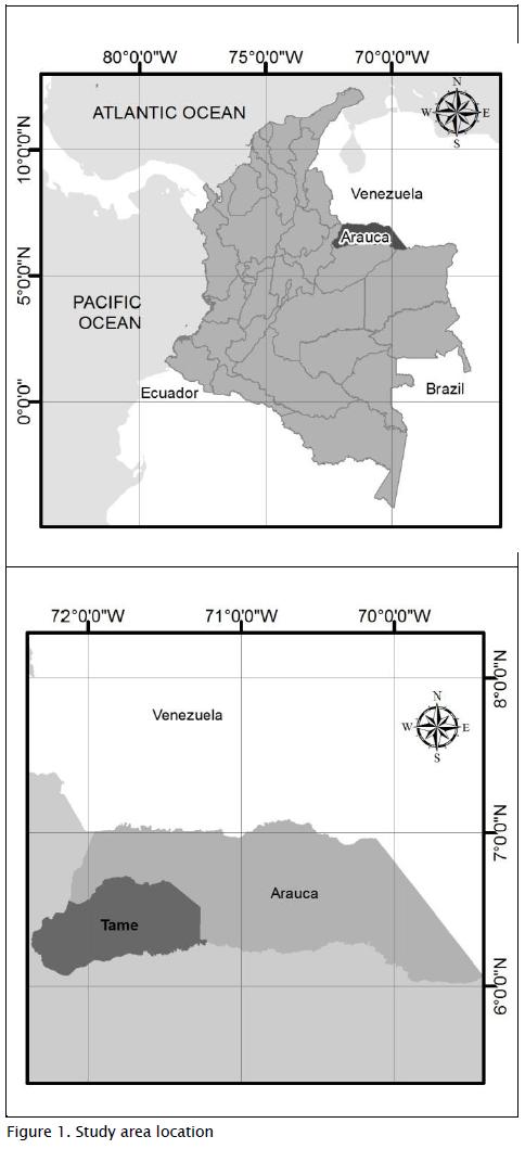
The research was undertaken in the municipality of Tame, Arauca department, Colombia. The municipality is located at 6°27' N and 71°46' W (Figure 1); it lies at 350 masl, having a rural population of 28,442, 19,134 urban inhabitants and 5,365 km2 surface area. Average annual temperature is 26°C, 2,200 mm average annual rainfall and predominant northeast wind direction. There are three main river systems (i.e. river basins): the Casanare River, the Cravo Norte River and the Ele River. The research area is home to the Sierra Nevada del Cocuy National Park located to the southwest of the municipality (see Figure 2).
Methodological proposal
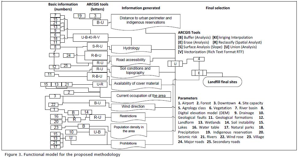
The hierarchical evaluation structure proposed by the current methodology led to identifying and the proper assessment of each criteria by using GIS (see Figure 3). The weighting scale proposed for the different municipal lands had a 0-1,000 point range; areas scoring close to the upper weighting limit had greater compatibility Figure 3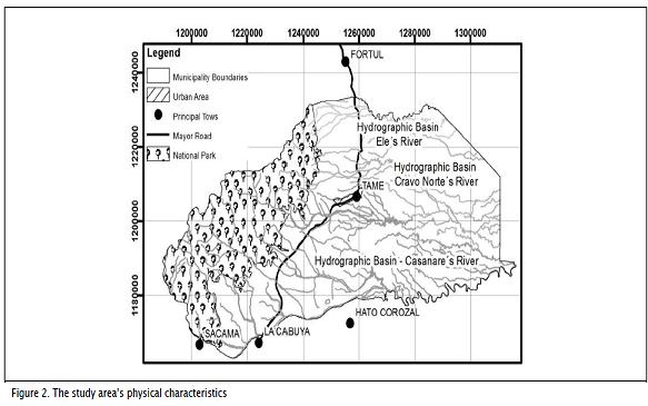
for positioning a solid waste disposal installation. The evaluation criteria are given below with their respective weighting ranges.
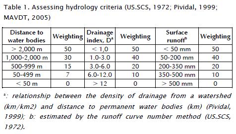
1. Hydrology: The surface water bodies connecting areas of life and their involvement can lead to damaging large areas regarding the survival of flora, fauna and communities located in areas of direct and indirect influence. The possibility of contaminant in surface water bodies thus requires evaluation (e.g. leachate) (Lee and Jones, 1991; Pividal, 1999; Abu-Rukah and Al-Kofahi, 2001). The evaluation included surface runoff and drainage index assessing the impact on the ease or difficulty offered by the territory so that leachate drainage could be integrated into permanent water bodies (Pividal, 1999) (Table 1).
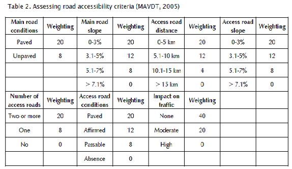
2. Road accessibility: This criterion assessed the ease and economics involved in collecting and transporting solid waste to the particular area in which final disposition would take place. Landfills must be located in places having alternative routes according to weather conditions. Alternatively, they should be located near highway networks to reduce construction costs involved in connecting roads and should not interfere with current and future traffic (TSWCR, 1991; MAVDT, 2005; Guiqin et al., 2009) (Table 2 ).
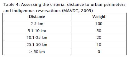
3. Distance to urban perimeters and indigenous reservations: The transportation costs involved in moving waste from a settlement to a final disposal area were considered (MAVDT, 2005; Sener et al., 2006; Geneletti, 2010). Collection and transport costs continue to be localities' largest budget items, even when the costs associated with solid waste disposal are rapidly growing (Ronen et al., 1983) (see Table 4 ).
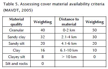
4. Availability of cover material: The transportation costs involved in moving cover material to comply with technical and environ-mental specifications in daily operation and landfill closure were considered (MAVDT, 2005; Sumathi et al., 2008) ( Table 5 ).
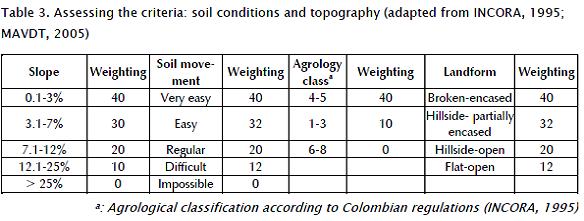
5. Soil conditions and topography: The slope, ease of soil movement, land use capacity and geomorphology are basic parameters in assessing a landfill's construction and operating costs (Pividal, 1999; Kontos et al., 2005; MAVDT, 2005). Landscape assessment was proposed with this criterion, as were the fragility of the environment from a visual standpoint and relief modification (Table 3).
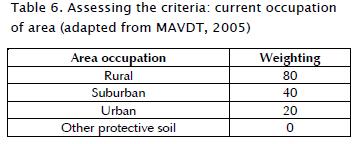
6. Current occupation of area: Landfills located close to human settlements have a large environmental impact, mainly associated with noise, smells and health vectors (Karagiannidis et al., 2004; Kontos et al., 2005; Christine et al., 2007). This work was thus aimed at predicting impacts on the community and natural resources (MAVDT, 2005) ( Table 6 ); soil protection regarding natural parks' perimeter buffer strips (i.e. transition zones) was included.
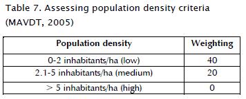
7. Population density: The possible involvement of the population located in the area of direct influence where final waste disposal was to be made was evaluated (MAVDT, 2005; Christine et al., 2007) ( Table 7 ).
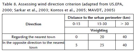
8. Wind direction: This criterion assessed the impact of landfill odour and particles (i.e. which might be carried by the wind to-wards populated settlements during disposal due to their weight) (US.EPA, 2000; Sarkar et al., 2003; Kontos et al., 2005) ( Table 8 ).
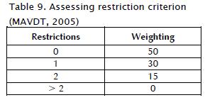
9. Restrictions: These involved areas where even though a landfill could be located, built and operated there, it had to comply with certain specifications and particular requirements without which its location, construction and operation was not possible. Restrictions: distance to urban land, proximity to airports, groundwater sources, unstable areas and high seismic risk areas (MAVDT, 2005) ( Table 9 ).
10. Capacity: The area required for the final disposition was obtained from solid waste production projections within an area of influence (i.e. 60 km radius regarding an urban perimeter) in relation to the projected horizon (i.e. 30 years). Areas equal to or greater than the required area obtained a 130 point weighting which descended linearly according to the available area (MAVDT, 2005).
11. Prohibitions: These concerned areas where landfill location, construction and operation was prohibited. Such prohibitions would include surface water sources, groundwater sources, critical natural habitats, national parks system areas and buffer zones and areas having geological faults (MAVDT, 2005). No weighting was allocated when rated within exclusionary criterion.
Results and Discussion
Applying the methodology
ArcGIS was used for processing basic information to identify and properly assess each criteria proposed by the methodology. The following were taken into account (i.e. base information) (Figure 3): airports, forests, downtown areas, site capacity, agrology class, vegetation, river basins, digital elevation model (DEM), drainage, geological faults, geological formation, landforms, wetlands, soil instability, lakes, water table, natural parks, rainfall, Indian reservations, seismic risk, rivers, prevailing wind direction, villages, major roads, and secondary roads. The models involved in assessing landfill capacity criteria gave an estimated 280,324 inhabitant population (i.e. within a 60 km radius of influence) for a projected 30 year horizon (2038). Estimated waste production was 323.2 tons per day for the required landfill area involving 176,965 m3 per year annual volume to be managed (i.e. solid waste plus in-termediate and final coverage). The calculation estimated 16 hectares for final disposition installation (trench or ditch excavated technology).
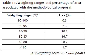
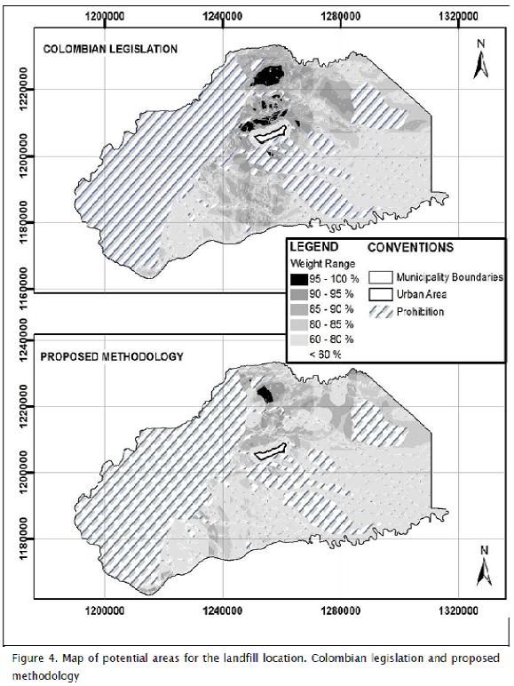
Table 10 shows the main results from applying the proposed methodology; the maximum weighting for each criterion is presented with its corresponding area. Once methodological criteria had been evaluated, the mapping overlap method was used to link the weighting in the same information layer; areas having prohibitions were then discarded. The resulting map is shown in Figure 4. It was decided to use weighting ranges from an established evaluation scale (i.e., between 0-1,000 points) for viewing the results (Table 11).
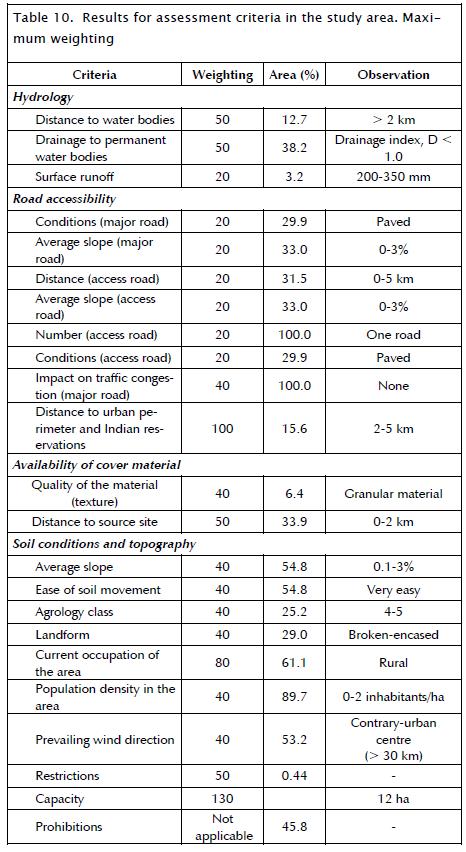
Table 11 shows that the proposed methodology estimated areas having the greatest potential for landfill location; 0.3% of the municipal surface (16.1 km2) had 95%-100% maximum score weighting and such area was located to the north of the urban centre of the municipality in the study (see Figure 4).
Methodological proposal compared to Colombian legislation
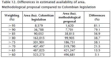
Colombian legislation (i.e. Decree 838) (MAVDT, 2005) was compared to the proposed methodology to assess differences in determining potential areas for landfill location. Paired Student t-tests revealed significant differences in potential area estimates. Figure 4 shows the maps obtained according to Colombian legislation guidelines and the methodological proposal. Regarding 95% maximum weighting (i.e. 1,000 points), the proposed methodology was 81% more restrictive than Colombian legislation in estimating area availability. As weighting increased, differences in area availability became greater (Table 12).
The criteria which led to differences between Colombian law and the proposed methodology are discussed below. Based on the literature concerning international reference methodologies reviewed, it was observed that criteria used by such researchers had been considered by Colombian legislation; however, such legislation is deficient regarding hydrological component evaluation, the main production factor and leachate impact evaluation which is why the proposed methodology criterion "1. Hydrology" was included.
The special treatment given to natural parks did not limit these areas' protection by means of prohibitions in their area of direct influence but linked areas of indirect influence having ecological, landscape and relief-type transitions such as buffer perimeter strips (see Criterion 6. Current occupation of area).
Agrological classes were discriminated by taking into account major land potential compared to a municipality's production dynamics (see Criterion 5. Soil conditions and topography). For example, it was determined that areas having high agricultural potential were not suitable for landfill location because they represented an opportunity for local and regional economies' growth and development. Consequently, the methodological proposal defined these areas as being environmentally sensitive and, therefore, that they be assigned zero weighting by virtue of their protected nature.
The distance effect on final installation concerning the spread of odours, dust and noise regarding the urban area of municipality was included in criterion "8. Wind direction".
Conclusions
The results showed that the methodological proposal regarding potential areas for identifying landfill location synthesised allows the criteria determining their construction, operation and closure. The evaluation criteria included environmental, economic, social and technical characteristics for determining the best territorial options for the municipalities being studied. It also showed that analysis and coordinated and systematic modelling using AHP, SAW and GIS led to obtaining accurate results.
The data showed that the proposed methodology was 81% more restrictive than Colombian legislation in estimating the area avail-able for landfill location regarding the weighting range between 95%-100% of maximum score (i.e. 1,000 points), mainly due to incorporating hydrology criterion including drainage index and surface runoff (i.e. absent in Colombian legislation). This assessed impact according to the ease or difficulty that the territory offered so that leachate drainage could be integrated into permanent water bodies.
The results led to increasing knowledge about development methodologies for landfill location in Colombian municipalities. This is useful for improving methodologies using GIS as a territorial analysis tool for locating waste disposal facilities.
References
Abu-Rukah, Y., Al-Kofahi, O., Assessment of the effect of landfill leachate on ground-water quality-a case study. El-Akader Landfill Site-North Jordan., Journal of Arid Environments, Vol. 49, No. 3, Nov., 2001, pp. 615-630. [ Links ]
Charnpratheep, K., Zhou, Q., Garner, B., Preliminary landfill site screening using fuzzy geographical information systems., Waste Management and Research, Vol. 15, No. 2, Feb., 1997, pp. 197-215. [ Links ]
Christine, A., Brent, K., Steven, J., Environmental justice and toxic exposure: toward a spatial model of physical health and psychological well-being., Social Science Research, Vol. 36, No. 1, Jan., 2007, pp. 48-67. [ Links ]
Chuang, P. T., Combining the analytic hierarchy process and quality function deployment for a location decision from a requirement perspective., International Journal of Advanced Manufacturing Technology, Vol. 18, No. 11, Nov., 2001, pp. 842-849. [ Links ]
Church, R., Geographical information systems and location science., Computers & Operations Research, Vol. 29, No. 6, Jun., 2002, pp. 541-562. [ Links ]
EPA, Title 40 Subchapter I-Solid waste, 258 criteria for municipal solid waste landfills., Environmental Protection Agency, USA, 2000. [ Links ]
Fatta, D., Saravanos, P., Loizidou, M., Industrial waste facility site selection using geographical information system techniques., International Journal of Environmental Studies, Vol. 56, No. 1, Jan., 1998, pp. 1-14. [ Links ]
Frantzis, I., Methodology for municipal landfill sites selection., Waste Management & Research, Vol. 11, No. 5, May, 1993, pp. 441-51. [ Links ]
Geneletti, D., Combining stakeholder analysis and spatial multicriteria evaluation to select and rank inert landfill sites., Waste Management, Vol. 30, No. 2, Feb., 2010, pp. 328-337. [ Links ]
Guiqin, W., Li, Q., Guoxue, L., Lijun, C., Landfill site selection using spatial information technologies and AHP: A case study in Beijing, China., Journal of Environmental Management, Vol. 90, No. 8, Aug., 2009, pp. 2414-2421. [ Links ]
Jensen, J. R., Christensen, E. J., Solid and hazardous waste disposal site selection using digital geographic information system techniques., The Science of the Total Environment, Vol. 56, No. 11, Nov., 1986, pp. 265-276. [ Links ]
Karagiannidis, A., Xirogiannopoulou, A., Perkoulidis, G. and Moussiopoulos, N., .Assessing the collection of urban solid wastes: a step towards municipality benchmarking., Water, Air & Soil Pullution, Vol. 4, Nº 4-5, 2004, pp. 397-409. [ Links ]
Kontos, T. D., Komilis, D. P., Halvadakis, C. P., Siting MSW Land-fills with a spatial multiple criteria analysis methodology., Waste Management, Vol. 25, No. 8, Aug., 2005, pp. 818-832. [ Links ]
Lee, G. F., Jones, A. R., Landfill and ground-water quality., Ground Water Journal, Vol. 29, No. 4, Aug., 1991, pp. 482-486. [ Links ]
Lin, H. Y., Kado, J. J., A vector-based spatial model for landfill siting., Journal of Hazardous Materials., Vol. 58, No. 1, Jan., 1998, pp. 3-14. [ Links ]
Lootsma, F. A., The Decision Analysis and Support Project., Journal of Multi-Criteria Decision Analysis, Vol. 9, No. 1-3, Mar., 2000, pp. 7-10. [ Links ]
MAVDT, Decreto 838, Localización de áreas para la disposición final de residuos sólidos., Ministerio de Ambiente, Vivienda y Desarrollo Territorial, Diario Oficial No. 45862, Mar., 2005. [ Links ]
MAVDT, Resolución 1390, Directrices y pautas para el cierre, clausura y restauración o transformación técnica a rellenos sanitarios., Ministerio de Ambiente, Vivienda y Desarrollo Territorial, Diario Oficial No. 46046, Sep., 2005. [ Links ]
Mondelli, G., Giacheti, H. L., Boscov, M. E. G., Elis, V. R., Hamada, J., Geoenvironmental site investigation using different techniques in a municipal solid waste disposal site in Brazil., Environmental Geology, Vol. 52, No. 5, May, 2007, pp. 871-887. [ Links ]
Pividal, A. J., Condicionantes geomorfológicos e hidrogeológicos para el emplazamiento de vertederos de residuos sólidos urbanos a escala regional., PhD thesis presented at the Universidad Complutense de Madrid, Geological Sciences Faculty, Geodynamics Department, Dec., 1999. [ Links ]
Ronen, R., Kellerman, A., Lapidot, M., Improvement of a solid waste collection system: The Case of Givatayim, Israel., Applied Geography, Vol. 3, No. 2, Feb., 1983, pp. 133-144. [ Links ]
Sarkar, U., Hobbs, S. E., Longhurst, P., Dispersion of odour. a case study with a municipal solid waste landfill site in north London, United Kingdom., Journal of Environmental Management, Vol. 68, No. 2, Feb., 2003, pp. 153-160. [ Links ]
SCS, National Engineering Handbook, Section 4, Hydrology., Soil Conservation Service, US Department of Agriculture, Washington D.C., 1972. [ Links ]
Sener, B., Suzen, M. L., Doyuran, V., Landfill site selection by using geographic information systems., Environmental Geology, Vol. 49, No. 3, Mar., 2006, pp. 376-388. [ Links ]
Siddiqui, M. Z., Landfill siting using geographic information systems: a demonstration., Journal of Environmental Engineering, Vol. 122, No. 6, Jun., 1996, pp. 515-523. [ Links ]
Sumathi, V. R., Natesan, U., Sarkar, C., GIS-based approach for optimized siting of municipal solid waste landfill., Waste Management, Vol. 28, No. 11, Nov., 2008, pp. 2146-2160. [ Links ]
TSWCR, Turkish Solid Waste Control Regulation., Ministry of Environment and Forestry, Turkey, Mar., 1991. [ Links ]
Turriago, A., Arrieta, G., Analysis of the production of solid waste and determination of production factors in three Colombian cities. A proposal for a new measurement methodology., Cuadernos Latinoamericanos de Administración, Vol. 6, No. 10, Jan., 2010, pp. 41-50. [ Links ]
Yesilnacar, M. I., Cetin, H., An environmental geomorphologic approach to site election for hazardous wastes., Environmental Geology, Vol. 55, No. 8, Aug., 2007, pp. 1659-1671. [ Links ]
Zamorano, M., Molero, E., Hurtado, A., Grindlay, A., Ramos, A., Evaluation of a municipal landfill site in southern Spain with GIS-Aided methodology., Journal of Hazardous Materials, Vol. 160, No. 2-3, Dec., 2008, pp. 473-481. [ Links ]

