


Services on Demand
Journal
Article
 English (pdf)
 Article in xml format
 Article references
 Send this article by e-mail
Indicators
-
 Cited by SciELO
 -
 Access statistics
Related links
-
 Cited by Google
 -
 Similars in
SciELO
Similars in
SciELO -
 Similars in Google
Share

 Permalink
Ingeniería e Investigación
Print version ISSN 0120-5609
Ing. Investig. vol.33 no.3 Bogotá Sept./Dec. 2013
L. Vega1, J. I. Ordoñez2 and G. Pinilla3
1 Leonel Vega Mora. Agricultural Engineer. MSc. PhD. Affiliation: Associate Professor, Civil and Agricultural Engineering Department, Universidad Nacional de Colombia, Colombia. E-mail: lvegamora@unal.edu.co
2 Jaime Iván Ordoñez. Civil Engineer. PhD. Affiliation: Titular Professor, Civil and Agricultural Engineering Department, Universidad Nacional de Colombia, Colombia. E-mail: jiordonezo@unal.edu.co
3 Gabriel Antonio Pinilla Agudelo. Biologist. PhD. Affiliation: Associate Professor, Biology Department, Universidad Nacional de Colombia, Colombia. E-mail: gapinillaa@unal.edu.co
How to cite: Vega, L., Ordoñez, J., Pinilla, A., Towards a systemic assessment of environmental impact (SAEI) regarding alternative hydrosedimentological management practice in the Canal del Dique, Colombia., Ingeniería e Investigación, Vol. 33, No. 3, December 2013, pp. 41 - 48.
ABSTRACT
The Canal del Dique, located on the Colombian Caribbean Coast, can be seen as an "artificial" branch of the River Magdalena. Since its inception in 1650, it has undergone a series of interventions aimed at optimising river navigation between Cartagena and the interior of the country, little consideration having been paid to institutional, economic, social and environmental impacts. This paper presents a systemic assessment of environmental impact (SAEI) methodology, based on systemic parameterisation of the environment, proposed by Vega [2011], for the strategic environmental assessment of policy, plans, programmes or large-scale projects, considering a case study of the Canal del Dique environmental rehabilitation as proposed by the Colombian government. Information arising from the framework of an inter-administrative agreement between the Universidad Nacional de Colombia and the Regional Autonomous Corporation for the Rio Grande de la Magdalena (CORMAGDALENA) was used for studying the environmental restoration of and navigation in the Canal del Dique [UN-LEH, 2008]. The authors developed and summarised SAEI regarding six alternatives for hydrosedimentological management in the canal to obtain results concerning environmental impairment or improvement regarding each factor considered, and the degree of aggressiveness or betterment involved in each alternative. Alternative 4, an enhanced version of current condition (ECC) would have produced the greatest environmental benefit (i.e. limited dredging plus optimising channel-wetland interconnection) requiring the narrowing of three straight reaches along the canal and the construction of a sluice-gate system in the Strait of Paracuica (near the town of El Recreo).
Keywords: Systemic assessment of environmental impact, strategic ecosystem, environmental impact, hydrosedimentological management.
RESUMEN
El Canal del Dique, ubicado en la Costa Caribe colombiana, puede considerarse como un brazo "artificial" del Río Magdalena. Desde su creación en 1650, ha sido objeto de una serie de intervenciones orientadas, todas ellas, a optimizar la navegación fluvial entre Cartagena y el interior del país y viceversa, con muy pocas consideraciones generadas sobre los impactos institucionales, económicos, sociales y ambientales. En este artículo se plantea y aplica como estudio de caso para la rehabilitación ambiental del Canal del Dique, propuesto por el Gobierno colombiano, la metodología de Evaluación Sistémica del Impacto Ambiental - ESIA, que basada en el proceso de "Parametrización Sistémica de la Dimensión Ambiental" propuesto por Vega [2011], se concibe como un procedimiento de "evaluación ambiental estratégica" para políticas, planes, programas de desarrollo territorial, y grandes proyectos. En consecuencia, a partir de la información generada en el marco del Convenio Interadministrativo celebrado entre la Universidad Nacional y la Corporación Autónoma Regional del Río Grande del Magdalena (CORMAGDALENA), para la realización de estudios e investigaciones de las obras de restauración ambiental y de navegación del Canal del Dique [UN-LEH, 2008], se recogen y sintetizan los principales aspectos relacionados con el proceso de Evaluación Sistémica del Impacto Ambiental para seis diferentes alternativas de manejo hidrosedimentológico en el Canal del Dique, lo que permite mostrar los resultados obtenidos, relacionados con el deterioro y/o mejoramiento ambiental sobre cada factor ambiental considerado y con el grado de agresividad y/o bondad de cada alternativa sobre el medio ambiente. Finalmente, se plantean algunas conclusiones derivadas de este proceso, donde se resalta la alternativa 4 (condición actual mejorada + tres (3) estrechamientos + el sistema esclusa-compuerta en el estrecho de Paricuica), por ser la que más bondades y mejoramientos ambientales generaría.
Palabras clave: evaluación sistémica del impacto ambiental, ecosistema estratégico, manejo hidrosedimentológico.
Received: March 8th 2012 Accepted: October 15th 2013
Introduction
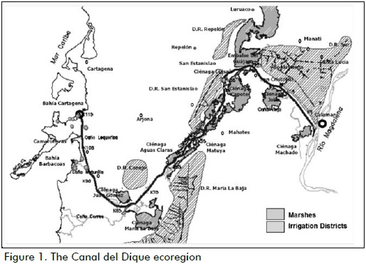
The Canal del Dique, which can be seen as an artificial branch of the River Magdalena (Figure 1), has left its mark on the history of Colombia. Its creation in 1650 was due to the governor of Cartagena, Don Pedro Zapata de Mendoza who, with 2,000 men, and in only six months, built connecting works between the brackish swamps along this abandoned track of the River Magdalena Delta, and extended the natural navigation system between the interior of the country and the city of Cartagena de Indias on the Spanish Main.
The people of Cartagena and the Colombian government conducted a series of interventions in the Canal del Dique ecoregion from 1571 to 1984 to optimise river navigation between Cartagena and the hinterland to facilitate trade and the region's socio-economic development:
- 1571 - end of the 18th century: communication was opened between the Bay of Barbacoas and the large Matuna Lagoon, by slash and cutting old mangrove swamps;
- 1650 - (Pedro de Mendoza): the dike separating the River Magdalena with the brackish marshes was broken and Matuna connected to Cartagena Bay through the Stero channel;
- 1844 and 1848: 8 kms of straight channel was constructed between the River Magdalena and the Sanaguare swamp, near the town of Santa Lucia;
- 1923 and 1930: the number of curves in the alignment was reduced to 250;
- 1934: Cartagena Bay was connected directly to the canal by cutting a channel through the mound of Paricuica;
- 1951-1952: the number of curves in the alignment was reduced to 93, plus the channel was widened;
- 1961: the Lequerica Channel was constructed to discharge some water into Barbacoas Bay; and
- 1981 and 1984: the number of curves was reduced to 50 and the channel widened further.
All these interventions increased the size and depth of the channel (average 100 m channel width, 3-5 m depth), resulting in large increases in water discharge rates (on average, the River Magdalena carries 7165m3/s, of which 540m3/s enter the canal near the town of Calamar on the left bank of the river, some 100 Km above the mouth beyond the city of Barranquilla. Only 130m3/s of those 540 m3/s reach Cartagena Bay at the mouth of the canal in the town of Pasacaballos.
Regrading solid discharge, the River Magdalena river carries an average of 170 to 250 million tons/year of sediment, of which 8.6 million tons/year enter the channel in Calamar and only 1.9 million tons/year reach Cartagena Bay in Pasacaballos. This has increased sedimentation in the bay, leading to some reduction in channel depth in Cartagena and Barbacoas Bays near the canal outlets. Although no significant danger to the navigation channels in the Bay of Cartagena exists as yet, there is fear for future problems and the gradual destruction of coral reefs in the El Rosario and San Bernardo Islands national park, near the coastline outside Cartagena Bay and to the west.
Such interventions have likely disturbed the ecoregion's environmental goods and services and resulted in:
- changes in hydraulic behaviour, sedimentology and the capacity for hydric regulation of the canal-wetland system;
- wetland eutrophication and desiccation;
- fish migration (locally called "subienda" for migrating upstream, and "bajanza" for migrating downstream);
- the extinction of a large number of species, (catfish, tilefish, doncella fish, needle alligator, manatee, tapir and northern screamer monkeys);
- mangrove swamp deforestation; and
- major changes in land use due to pressure to expand livestock grazing over marshy areas.
It is likely that the above impacts have also affected the quality of life of the population living in the ecoregion in terms of socioeconomic conditions, basic sanitation, food security, health, housing, infrastructure and education.
The above interventions incorporated few environmental considerations regarding the conservation, sustainable use, and recovery of environmental goods and services in this important ecoregion, or the management and control of these resources. One exception can be quoted; the requirement from the former Colombian Institute of Renewable Natural and Environmental Resources (INDERENA), in 1984, to decrease bottom sediment transport into the canal through the operation of sediment traps in four places along the channel, the establishment of accumulation areas for dredged material and a minimum of two annual dredging operations in Calamar and Pasacaballos, conditions which were soon abandoned by canal administrators.
Based on technical, environmental, economic and social considerations, national convenience and legal requirements (but mainly through precautionary), the Ministry of the Environment (MMA) issued resolution 260/1997 which requested CORMAGDALENA (as the entity responsible for the River Magdalena and Canal del Dique navigability) to submit a, "Plan for the environmental restoration of the degraded ecosystems in the area of influence of the Canal del Dique," within 24 months. The general objective was, "to reduce sedimentation in these bodies of water for the purpose of mitigating environmental damage and ensuring that the Canal del Dique region's productive activities should encompass the concept of sustainable human development for the improvement of the working and living conditions of the communities settled in the area of channel influence" (MMA-resolution No. 260/1997).
Since this resolution was passed, a series of technical and administrative action by the MMA and CORMAGDALENA led the new Ministry of Environment, Housing and Territorial Development, (MAVDT) to issue resolution 0249/04, ordering CORMAGDALENA to, "define and design alternative sedimentological management practices for the Canal del Dique which, in addition to minimising sediment contribution to the Bay of Cartagena, would ensure the navigability of the channel, a suitable water supply for human consumption and for existing and projected irrigation districts, the prevention and mitigation of environmental impact on fishing, agriculture and livestock and on the life of residents and environmental support for existing species and ecosystems" [MAVDT-resolution No. 0249/2004].
To meet MMA technical requirements and ensure that these aspects were considered and resolved in the alternative sedimentological management scheme for the Canal del Dique, CORMAGDALENA hired the Universidad Nacional de Colombia to conduct studies on the environmental restoration of the Canal del Dique and navigation practice based on previous studies by Universidad del Norte (UNINORTE) [2002]. Such studies had recommended an alternative for hydraulic management, (dubbed "Alternative IV"), based on discharge control, by constructing a gate and lock system at the entrance to the canal in Calamar, with ecological access "ensured" by dredging the "Caño Viejo", an old access to the canal, abandoned years before, which required closing the left arm of Becerra island, upstream from Calamar.
The systemic assessment of environmental impact conceptual and methodological approach
The proposed systemic assessment of environmental impact (SAEI) integrated and parameterised an ecosystem's institutional, economic and social aspects in a particular region or area of influence. It evaluated the most relevant management scenarios and the environmental impact generated by them, defining measures for their prevention, mitigation or elimination, guiding decision-making and defining general and specific guidelines for a region's environmental and territorial development.
The SAEI approach was developed from environmental impact assessment of projects, basically following the typical phases involved in the normal development of an engineering project. Nevertheless, "strategic environmental assessment" methodology and process concerning policy, plans, programmes and projects has a different connotation regarding typical environmental impact assessment.
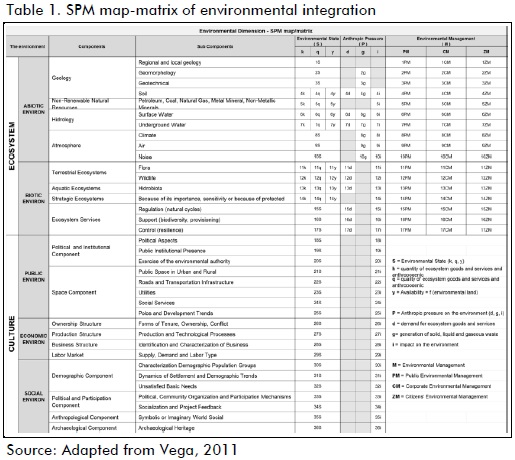
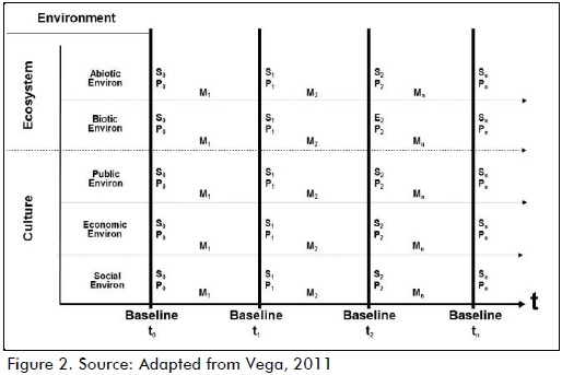
Although this methodology was based on an adaptation and evolution of the original methodology for identifying and assessing environmental impact by Leopold [1971], Battelle-Columbus [1972], Gómez Orea [1994] and Conesa, [2003], its development has mainly emerged from a research project entitled, "Towards systemic parameterisation of the environment," [Vega, 2011]. This defined methods and tools concerning systemic environmental information regarding resource quantity and quality, to be collected and organised within a state-pressure-management (SPM) framework. This was systematically stored with the help of SPM map-matrix, (see Table 1), using environmental information baselines (EIB) (Figure 2).
The SAEI methodology used multi-criteria analysis (MCA), in which each action, (Aj) or scenario of significant anthropogenic management (k), was interrelated in a qualitative, quantitative, stochastic or diffuse manner with each element in the environ-ment (i.e. environmental factors) (Fi) which could have been affected. This allowed the assessment, evaluation and analysis of environmental impact generated by such interaction within a logical framework (summarised in Table 2 and described below).
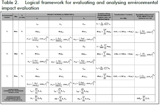
According to the evaluation and analysis logical framework (Table 2), the total environmental impact (TEI) of a project or alternative (k) could be determined by the weighted sum of the impact value (Vi) of each environmental factor (Fi), as expressed by equation 1:
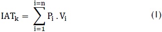
where:
Pi = weighted environmental importance: the weight or relative importance of each environmental factor concerning the environment being considered. This value could vary from 0 to 1,000, and was mapped by consensus with a panel of experts.
Vi = net impact value regarding each environmental factor Fi.
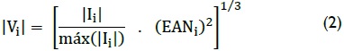
The intrinsic importance of the impact on each environmental factor and net environmental state (condition with project minus condition without project) had a value varying from -1 to 1. Its sign was that of total intrinsic importance Ii and was calculated using equation 2, as follows:
where:
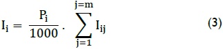
Ii = the intrinsic importance of impact on each environmental factor Fi. This value was calculated using equation 3 and, depending on the positive or negative sign, was assimilated qualitatively to generate a relative degree of environmental damage or improvement for the environmental factors considered, as follows:
where:
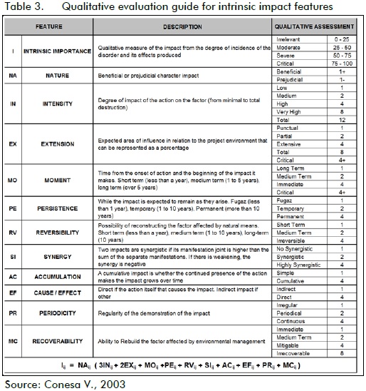
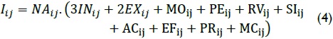
Iij = the intrinsic importance of impact generated by action on environmental factor. This value was calculated using equation 4, relating the intrinsic characteristics of environmental impact and which was evaluated by a panel of experts, with the help of Table 3.
EANi = net environmental state index for environmental factor Fi. This value ranged from 0 to 1 and was calculated using equation 5:

where:
Mcpi = magnitude of environmental factor Fi with project
Mspi = magnitude of environmental factor Fi without project (baseline)
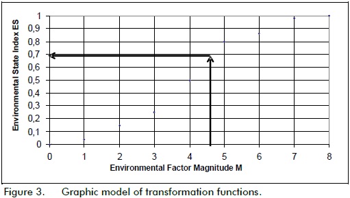
f(Mi) = transformation function for environmental factor Fi converts dimensional magnitude of environmental factor Fi in terms of a dimensionless environmental state index, as illustrated by the example in Figure 3.
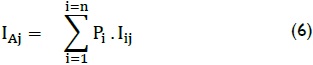
The evaluation analysis framework (Table 2) was also used for determining the intrinsic importance of the environmental impact generated by each action Aj. This value was calculated by using equation 6 and, depending on the positive or negative sign, could be qualitatively assimilated to generate the relative degree of environmental damage and/or improvement for each action on the environment in question, as follows:
Using SAEI methodology for evaluating hydrosedimentological management alternatives for the Canal del Dique.
Depending on the development phases of a plan or programme being considered, the evaluation methodology would involve evaluation and analysis of environmental impact; it would be qualitative for the feasibility phase and the selection of alterna-tives and quantitative for the feasibility phase of the selected alternative. This logical framework is summarised in Table 4.
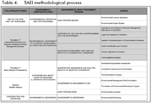
The hydrosedimentological management scheme for the Canal del Dique was only systematically evaluated for the feasibility phase (highlighted in grey in Table 4), involving qualitative envi-ronmental assessment of alternatives. This implied describing the project and the environment through systemic parameterisa-tion of the ecoregion's environment [Vega, 2011] and identifying, assessing and the qualitative analysis of the environmental impact of the alternatives generated in each scenario considered, as described below.
Doubts emerged while conducting the studies concerning the relevance and efficiency of alternative IV as initially proposed by UNINORTE (2002). These were corroborated by the modeling results [UN-LEH, 2008] which indicated that the proposed alternative would fail because the entrance to the canal would be blocked by coarse material which would impede vessels' entry to the sluice. Flow speed and sedimentation of the return flow around the left arm of Becerra Island was also found to cause rapid obstruction of the passage, due to the accumulation of fine sediment and vegetation, as well as the likely destabilisation of the river upstream and downstream from Calamar.
This alternative was discarded, in agreement with CORMAG-DALENA, and, four new alternatives were proposed instead and defined for preliminary evaluation: Alt. 1, current condition; Alt. 2, enhanced current condition; Alt. 3, enhanced current condi-tion + placing a sediment excluder at the entrance in Calamar; and Alt. 4, discharge and sediment entrance control by placing a gate and lock system in Calamar.
The evaluation made it clear that the canal's current operating conditions, involving minimum periodic dredging and impaired flow connections with the peripheral system of wetlands, were harmful to the environment and the welfare of its population. It was also concluded that, although the other alternatives involved substantial net benefits and improvements for the environment, none of them would be optimal without effective government presence in the ecoregion, through environmental agencies.
Taking into consideration the principles of caution, gradualism, cost-effectiveness and continuous improvement, the Universidad Nacional de Colombia recommended a stepped solution. This involved the immediate implementation and development of Alt. 2, since its management practice was common to all the other alternatives considered and represented significant improvement which did not require large investment, while allowing for the continuation of studies regarding other management alterna-tives, and in-depth evaluation of yet-to-be considered elements.
CORMAGDALENA thus commissioned the Universidad Nacional de Colombia to continue research into two new alter-natives, insisting on the reduction of discharge in the channel, but allowing the university to try an approach different from a gate and lock system by narrowing different sectors of the canal and building a different gate-lock system at the end of the align-ment in the Paricuica Strait rather than at the beginning of it. This involved a solution that allowed a large portion of the flow to be evacuated to the sea through the Bay of Barbacoas without reaching Cartagena with its sediment load, thus making the reduction of discharge smaller and better accepted by the canal-wetland system.
The university identified and selected six new hydrosedimentological management alternatives (see Table 5).
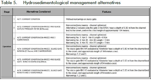
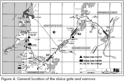
The preliminary location of the narrow channel sectors and the location of the new lock-gate system at Paracuica are shown in Figure 4 as a result of the university's hydraulic modelling.
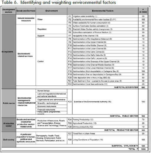
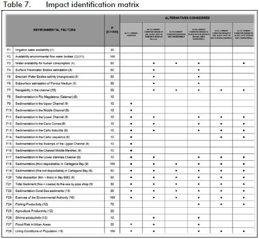
An expert panel4 identified and weighted environmental factors likely to be affected in accordance with the environmental pro-tection requirements set out in MAVDT resolution 0249/04, (Table 6) and characterised significant environmental impacts for each alternative considered (Table 7).
The panel of experts characterised and determined the intrinsic importance of each identified impact, in accordance with equa-tion 4 and the guidance of intrinsic qualitative assessment of impact (Table 3), using an Excel application specifically designed for processing information. Mathematical modelling [Camacho, 2008], physical modelling [Ordóñez, 2008] and limnological modelling [Pinilla et al., 2010] were firmly taken into account during this step.
Intrinsic importance impact Fi for each environmental factor and the intrinsic importance of the environmental impact generated by each alternative Aj were calculated, following the logical framework for assessment, evaluation and analysis set out in Table 2.
Results and Discussion
The relative values for intrinsic importance of impact on each environmental factor (Fi) for each of the six alternatives considered are illustrated in Figures 5, 6, 7, 8, 9 and 10. The data were qualitatively assimilated to generate a relative degree of damage or improvement concerning each environmental factor considered.
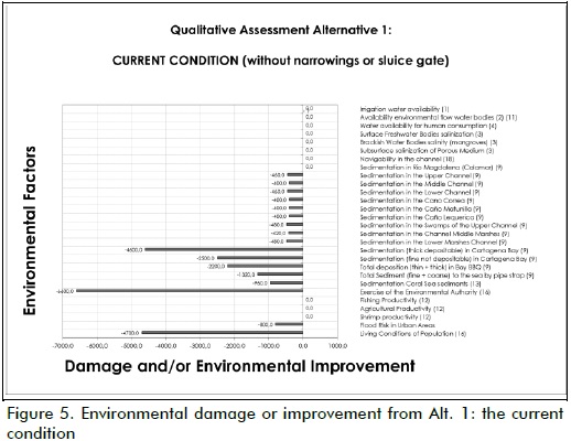
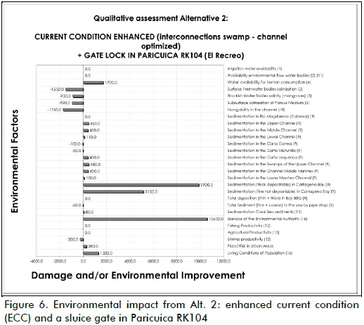
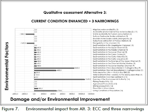
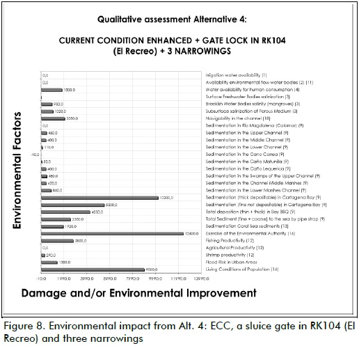
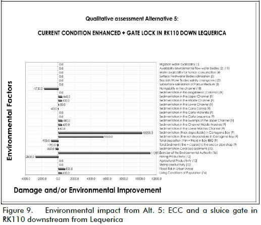
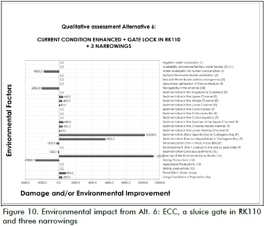
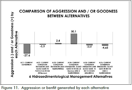
Figure 10 represents relative intrinsic values for the environmental impact generated by each alternative considered. These values were qualitatively assimilated to generate a relative degree of environmental damage or improvement due to each alternative.
Figures 5 to 10 show that all the alternatives produced net environmental damage and improvement for each environmental factor evaluated here. However, Alt. 4 (enhanced current condition, the three narrowed straits and a sluice-gate system in the strait of Paricuica) produced only net improvement, as displayed in Figure 8.
Figure 11 shows the comparative analysis between damage and benefit for each alternative highlighted the Universidad Nacional de Colombia's Alt. 4 as being the most suitable alternative as it provided the greatest benefit for the environment. This should guide decision-making towards such alternative.
It is clear that any alternative which is finally selected should further undergo a detailed environmental impact evaluation to facilitate the formulation of an environmental management plan to effectively ensure the prevention, elimination, mitigation or control of impacts. Consequently, if the alternative chosen does not meet expectations regarding efficacy and efficiency, the management practice chosen must have a high degree of reversibility, so that it can be removed easily, and at minimal cost.
Conclusions and recommendations
The systemic environmental impact assessment (SEIA) developed and used here for assessing hydrosedimentological management alternatives for the Canal del Dique represented a valid option for environmental impact assessment.
It required the availability of abundant high-quality information. However, once such information was collected, aggregated and organised within the SPM framework, the identification and valuation (qualitative and quantitative) of environmental impact through MCA and the indicative systematisation of these results greatly facilitated analysis and decision-making regarding environmental impact evaluation.
The following actions are recommended prior to decision-making and development concerning environmental licensing of any alternative selected and in accordance with the principles of caution, gradualism, cost-effectiveness and on-going improvement.
The enhanced current condition should immediately be adopted, i.e. optimising dredging and that of the channel-wetland interconnections. In addition to being urgent and common to all the alternatives, developing these interconnections represents a significant improvement which will not require major investments or cause an irreversible impact. Moreover, this development will facilitate ongoing study of alternative management practice and assessment of yet-to-be considered elements.
Experimentation and investigation in situ should be continued to facilitate monitoring, tracking and evaluating ECC and its subsequent complementation with other action which should continue to be the subject of evaluation and study.
The authors thus recommend not one alternative or optimal hydrosedimentological management practice, but a fundamental environmental management plan for the sustainable development of the Canal del Dique ecoregion and its water sources.
4 The panel consisted of Dr. Jaime Iván Ordoñez, I.C. PhD. Hydraulic Engineering and Physical Modeling; Dr. Gabriel Pinilla, Biologist, MSc. PhD. Limnology; Dr. Luis Alejandro Camacho, I.C. MSc. PhD. Mathematical Modeling; Geol. Manuel Moreno, Geology, MSc. Geomorphological Processes; and Dr. Leonel Vega Mora, MSc. PhD. Water Resources and Environmental Engineering.
References
Battelle-Columbus Laboratories., Environmental Evaluation System for Water Resources Planning., Columbus, Ohio, Bureau of Reclamation U.S. Department of Interior, 1972. [ Links ]
Camacho, L. A., Modelación hidráulica de la ecorregión del Canal del Dique., Bogotá, Universidad Nacional de Colombia, 2008. [ Links ]
Conesa, V., Guía Metodológica Evaluación Impacto Ambiental., 3rd Ed., Madrid, 2003. [ Links ]
Forman, R. T., Some general principles of landscape and regional ecology., Landscape Ecology, Vol. 10, No. 3, 1995, pp. 133-142. [ Links ]
Gómez Orea, D., Evaluación de Impacto Ambiental., Madrid, Editorial Agrícola Española S. A., 1994. [ Links ]
Leopold, L. B., Clark, F. E., Hanshaw, B. B., Balsley, J. R., A procedure for evaluating environmental impact U. S. Geological Survey., Circular 645. Washington, 1971. [ Links ]
Ministerio de Ambiente, Vivienda y Desarrollo Territorial (MAVDT) - Resolución 0249/04. Por la cual se establece a CORMAGDALENA definir y diseñar una alternativa de manejo sedimentológico del Canal del Dique., Bogotá, Ministerio de Ambiente, Vivienda y Desarrollo Territorial, 2004. [ Links ]
Ministerio del Medio Ambiente (MMA) - Resolución No. 260/1997. Por la cual se solicita a CORMAGDALENA, como responsable de la navegabilidad del río Magdalena y el Canal del Dique, presentar en un plazo de 24 meses, un "Plan de restauración ambiental de los ecosistemas degradados del área de influencia del Canal del Dique"., Bogotá, Ministerio del Medio Ambiente, 1997. [ Links ]
Ordoñez, J. I., Modelación física para el manejo hidrosedimentológico del Canal del Dique., Universidad Nacional de Colombia, 2008. [ Links ]
Pinilla, G., Duarte, J., La importancia ecológica de las ciénagas del Canal del Dique y la determinación de su estado limnológico. Informe Interno., Bogotá, Universidad Nacional de Colombia, Laboratorio de Ensayos Hidráulicos, June, 2006. [ Links ]
Pinilla, G., Duarte, J., Vega, L., Índice de estado limnológico (IEL) para evaluar las condiciones ecológicas de las ciénagas del Canal del Dique., Acta Biológica Colombiana, Vol. 15, No. 2, 2010, pp. 169-188. [ Links ]
Universidad del Norte (UNINORTE)., Canal del Dique. Plan Restauración Ambiental., Barranquilla, CORMAGDALENA, 2002. [ Links ]
Universidad Nacional de Colombia - Laboratorio de Ensayos Hidráulicos (UN-LEH)., Estudios e Investigaciones de las obras de restauración ambiental y de navegación del Canal del Dique., Informe Principal. Convenio Interadministrativo UN-LEH-CM-037/2005, Bogotá, 2008. [ Links ]
Vega, L., Toward the systemic parameterization of the environmental dimension., Revista Ingeniería e Investigación, Vol. 31, No. 1, April, 2011, pp. 242-253. [ Links ]
Vega, L., Hacia la Sostenibilidad Ambiental del Desarrollo. UNAL-IDEA., Bogotá, ECOE Editores, 2005. [ Links ]
