


Services on Demand
Journal
Article
 English (pdf)
 Article in xml format
 Article references
 Send this article by e-mail
Indicators
-
 Cited by SciELO
 -
 Access statistics
Related links
-
 Cited by Google
 -
 Similars in
SciELO
Similars in
SciELO -
 Similars in Google
Share

 Permalink
Ingeniería e Investigación
Print version ISSN 0120-5609
Ing. Investig. vol.35 no.1 Bogotá Jan.Apr. 2015
https://doi.org/10.15446/ing.investig.v35n1.46071
DOI: http://dx.doi.org/10.15446/ing.investig.v35n1.46071
H. Paz1, J. A. Arévalo2 and M. A. Ortiz3
1Hernán Paz. Ph. D. Education of the Universidad Pedagógica de Colombia, Master in Teleinformatic, Universidad Distrital "Francisco José de Caldas" and Electrical Engi-neering, Universidad Nacional de Colombia, Colombia. Affiliation: Associate Professor, Escuela Colombian de Ingeniería Julio Garavito, Bogota, Colombia. E-mail: hernan.paz@escuelaing.edu.co
2Johnny Alexander Arévalo. Electronic Engineer, Escuela Colombiana de Ingeniería Julio Garavito, Colombia. Affiliation: Coinvestigador Proyecto, COLCIENCIAS, Colombia. E-mail: johnny.alexander@escuelaing.edu.co
3Marco Andrés Ortiz. Electronic Engineer, Escuela Colombiana de Ingeniería Julio Garavito, Colombia. Affiliation: Coinvestigador Proyecto, COLCIENCIAS, Colombia. E-mail: marco.ortiz@escuelaing.edu.co
How to cite: Paz, H., Arévalo, J. A., & Ortiz, M. A. (2015). Design and development of an electronic device for data transmission with universal coverage. Ingeniería e Investigación, 35(1), 86-91. DOI: http://dx.doi.org/10.15446/ing.investig.v35n1.46071
ABSTRACT
This paper presents the design and development of an electronic device with cellular and satellite coverage for localization and tracking of mobile assets in Colombia (public transport, freight, carriers, etc.). The development of this product integrates hardware, software and communication interfaces. It is aligned with a need identified in the market by the company One Solution Position: OSP LTDA. With this technology transfer we intend to improve the offer of wireless services for mobile asset tracking with a solution that covers the following features: dual operation (cellular/satellite), versatile, economical, low-power consumption, and based on international standards FCC and CE Mark.
Keywords: GPRS technology, satellite device, location, tracking, mobile assets.
RESUMEN
Este artículo presenta el diseño y desarrollo de un dispositivo electrónico con cobertura celular y satelital para la localización y el rastreo de activos móviles en Colombia (transporte público, transporte de carga). El desarrollo de este producto integra hardware, interfaces de comunicaciones y software, y está alineado con una necesidad detectada en el mercado por la empresa One Solution Position: OSP LTDA. Con esta transferencia tecnológica se busca implementar mejoras en la oferta de servicios inalámbricos para seguimiento de activos móviles mediante una solución dual celular/satelital, versátil, económica, de bajo consumo y ceñida a la normatividad internacional FCC y CE Mark.
Palabras clave: Tecnología GPRS, dispositivo satelital, localización, seguimiento, activos móviles.
Received: October 8th 2014 Accepted: February 16th 2015
Introduction
Colombian telecommunications is a dynamic sector in continual growing of users and new services that offer multiple opportunities to the electronic engineering for the development of pertinent solutions for assets tracking and monitoring.
It was identified that wireless communication market, specifically in technological solutions for tracking and following mobile assets, offers GPRS transmission equipment with cellular coverage (Competitive National Politics, 2014). Limitations of these kind of solutions are that, there is not GPRS infrastructure in remote regions and information stream is maintained while an antenna coverage exists. Recently, user enterprises of GPRS devices who need to guarantee its continual service, must replace their modules with dual technological solutions that combine a land transmission mode (GPRS) and a satellite mode (GPS). However, most of the enterprises do not have de disposition to make new inversions due to the high costs.
In that context, the Escuela Colombiana de ingeniería Julio Garavito University (developer entity) and the OSP company (benefactor entity) combined efforts to design and develop an electronic device with cellular/satellital coverage, named as OSP/Satellite device, that takes existent GPRS units (Syrus®-DCT and TT8750-skypatrol®) and makes them compatible for satellite transmissions in order to guarantee a versatile, low cost, low consumption, universal coverage and international standards compliant device.
In this article, the experience of designing and building an electronic device is presented; besides, the working results are presented by test data transmission.
Theoretical framework
GPRS (Global Packet Radio Service) is a standard that shares the frequency range of the GSM network using data transmission in “clusters”. In this technology, communicative channels are dynamicallay shared between different users (Zhao, et al. 2009). The principal advantage of this technology is the possibility of having a permanent terminal plugged, checked only for the volume of data send and received, and not for the connection time as happens in the transmission by circuit commutation.
Even if GPRS data rate (56 kbps – 115.2 kbps) may seem obsolete for internet navigation, it is not for the development of this research, due to the low data rate needed for information transmission of mobile assets localization and tracking.
The satellite device uses a technology that works with a low orbit satellite network that generally spin bellow 5035km (Paz, 2009; Sendin, 2004). Its functionality goes beyond tracking and following mobile assets and allows data transfer in simplex and/or duplex mode with low latency and global coverage (On-Medany, 2010; Schenewerk, 2003). This service is provided now by different companies such as Iridium® (Iridium communications, 2014), Globalstar® (Axxon-Globlastar, 2005), OrbComm® (Orbcomm system review, 2001), which have their own satellite constellation LEO and of satellite modems.
Now a day there are diverse wireless communications systems for tracking and/or control mobile assets (vehicles, buses, etc.) with local or regional coverage by GPRS (Sony/Ericsson®, Enfora® GSM2218, Hunter Pro®, Syrus® y Skypatrol®), national or universal coverage by satellite modems (EIT ®, Iridium®, Globalstar®, Inmarsat®, Orbcomm®), or duals that combines both technologies (Matrix®, Todoelectrónica®, etc.). Anyway, a wide and varied offer of solutions for tracking and following mobile assets in real time is available in the market (Ojeda, et al., 2011), but all of them are expensive and not accessible through the electronics local market.
The current Colombian normativity for the telecommunication sector policy is to regulate guideline for services and not technology. With that sight, it was necessary to check the international normativity: FCC (FCC rules, 2014) and CE Mark (Guidelines, 2014), with the main goal of guide the design and build of the OSP/Satellite device with international standards.
FCC normativity refers to the correct use of frequencies and electromagnetic wave emission without interferences. For compliance of FCC normativity in the development of the OSP/Satellite device parts 15 and 25 that refer to unintentional radiations, intentional radiation and restrictions over any kind of satellite communications were followed.
In the CE MARK normativity, that regulates the production, distribution and commercialization of electronic devices for the European Union, other points are required: design and build a device able to operate in an assigned band, give the device specifications to the client in a sheet and use minimal quantities of dangerous substances (cadmium, lead, mercury, polybromophenyls, etc.) that can affect the environment and human health. For the latter purpose there is RoHS (Restriction of Hazardous Substances) certification (CE MARK, 2014).
Methodology
The design and development of an electronic device that allows satellite transmissions for tracking and following mobile assets will imply the precise knowledge of its relative location coordinates and the monitoring of variables of the mobile assets that are of interest for the final user, and that will be transmitted towards a register center for control, logistic, administration and auditory of the information.
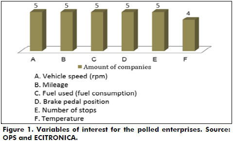
In order to respond to specific user needs a questionnaire survey that had two parts and six open questions with short answers was applied. The survey was answered by five enterprises that are users of cellular coverage devices (AVL: Automatic Vehicle Location) See table 1.

In general, polled people in enterprises coincide on the variables of interest for their respective enterprises. See Figure 1.
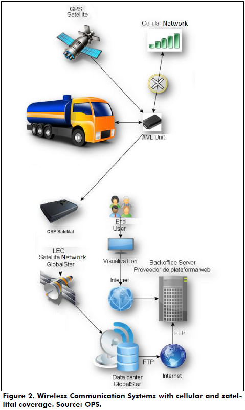
The electronic device pertinent to the needs of the user enterprises considered the development of hardware, communication interfaces and software for its performance in the operative stage that is shown in figure 2.
This electronic engineering work also had in mind the following market requirements: 1) Possibilities of universal coverage (it was implemented to reach national and regional coverage that comprehends Andean zone countries); 2) From the monitoring center, the continuous offering of regular location uploads of the mobile actives; 3) The GPRS modem will work with low frequencies respect from 3G and 4G technologies, which guarantees a low battery consume. 4) The low battery consume will be guaranteed by the following strategies: STX2 deactivation when it is not transmitting, PWM signal for LED’s visualization feed and change the microcontroller to hibernation status when it is not transmitting; 5) The approximate dimensions of the electronic device are: 9.2x6.3x4.0cm; approximate weight: 400g; Satellital Antenna: 5m of wire; 6) The electronic device broadcast RF power levels allowed, to avoid electromagnetic interferences; 7) This device will operate with GLOBALSTAR® satellital network, in low orbit to 1414km, Band L, F=1616.25MHz, BW=7.5MHz (Hui and Xuemai, 2006); 8) Maximum capacity of sending information: 16 messages (144 bytes), compatibility: Syrus-DCT, TT8750- Skypatrol; 9) The electronic device will be feed with a range of voltage that will oscillate between 2.7V and 5.5V, with a Imax of 1.1A, and it will have a 3.7V – 1000mA/h lithium internal battery. Charge time: 4h. Reception sensibility: -93dBm; 11) this device will have an integrated smart Bluetooth terminal to 2.4GHz and transmission power from 0dBm to -23dBm.
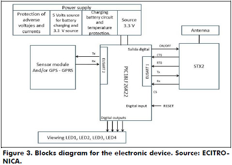
Hardware modeling of the OSP/Satellite device:
As it is shown in Figure 3, the hardware design of the electronic device consist of internal modules, ports for external modules, Bluetooth, STX2 satellital and microcontroller.
Modeling of the communication interfaces
The design of the communication interfaces with serial asynchronous EUSART (Enhanced Universal Synchronous Asynchronous Receiver-Transmitter) for the interconnection of the circuit blocks (hardware) will allow to ensemble (Electronic device) the transmission of satellite information over the coordinates of the mobile asset and values of the electrical variables captured by the GPRS existent system (sensors module).
Internal modules are communicated with each other by interfaces as shown in Figure 4. These show the way that follows the information flux.

As shown in Figure 5, the information captured by the external module sensors and saved in the microcontroller can also be received in a smartphone, tablet or laptop with Bluetooth communication.

The reception software was developed in programming language Python that will be executed in a machine with an operative system Ubuntu 14.4, and which main goal is to detect through a socket, the moment in which a satellital message is received in the server, capture the information contained in the message, decode it and give it back trough an e-mail.
For the socket management a script was made. Initially this script is executed in the server of the benefactor enterprise OSP in order to receive satellite data sent by the OSP/Satellite device.
To check the OSP/Satellite device work the next steps were followed: 1) Install a FTP service on the server, that allowed the reception of XML files, that for the first test were sent from GLOBALSTAR to an e-mail with the satellite message information required; 2) a script was developed allowing the following activities start at the same time:
- Get connected to an e-mail.
- Make a directory event notifying that when validating the creation of new XML files in a specified route, opens them, extracts the information, decoding and after sends to the development engineers’ e-mail the decoding information with the XML file attached.

Tests and results of the electronic device
The designed and developed electronic device will allow the transference of data between the final user and its asset, that will be made by the use of GPRS technology for zones in Colombia with cellular network coverage, and with LEO satellite communication modem for those zones that do not have GPRS coverage.
Transmission rates of the electronic device to the final user were adjusted in such a way that data flow between modules is appropriate, does not rewrite the information nor generates unnecessary energy consumption.
Its technical specifications are described in the following table 2.

From the first and only test some fractions were received on the e-mail with content such as what is shown in the figure 7. With the basis of this information the XML file was created.

Once the XML file is created, the script automatically opens it to make the decoding.
The created file is decoded by the script, which is executed in the reception server, and a new e-mail message is sent to the development engineer for information validation.
In the content of the mail it is shown the understandable information that has the following data:
- Date
- Hour
- Latitude
- Longitude
- Event
- Orientation
- Speed
- Hexadecimal representation
- Binary representation
- Google-maps link to see the coordinates in a map
Besides, the mail contains the XML file attached to verify the information.
Challenges for future designs
A constraint that is presented in the design of an electronic device is that the integrated circuit STX2, that is used in the project and is commercialized by GLOBALSTAR®, counts with a transmission mode of simplex information, without detection and errors correction over the sending of the data to the final customizer (Goldsmith, 2005); in consequence, the reliability of the transmitted data is not guaranteed. To solve this issue techniques that allow error correction in the receptor without retransmission of the original information were applied (FEC: Forward Error Correction).
GLOBALSTAR® satellites network, that will facilitate to the electronic device its universal coverage, presents availability between 90% and 95%, with a delay of the communications of 20µs, approximately (Gagliardi, et al. 2003).
Due to the electronic device user is not disposed to pay more money than to the send of the message, it is necessary the compression of the information of the locate coordinates of the mobile asset and analogic entrances or digitals that inform about the driver behavior and gas consumption, (these information cannot exceed a 9 bytes message).
The protocol for the serial communication RS-232 between the conventional AVL devices (commercialized in Colombia) and the electronic device, based in ASCII, generates processing consumption in the microcontroller of both devices. This procedure could be made in the software and so reducing the size in firmware.
The design of any electronic product with compliment of an international standard can be performed from two perspectives: starting at zero and guide the design process (stage by stage) with the compliment of the respective recommendation; or start from the selection of the elements of the desired certification. In that case it is wished to compile the standard related to the integration and performance of the device in general.
Conclusions
The electronic device reused equipment GPRS or also called units Automatic Vehicle Location: AVL, specifically TT8750 + of Skypatrol and SYRUS DCT, which are used for locating and tracking mobile assets with cellular coverage, and they add a channel satellite backup via modem STX2 Globalstar®, to ensure continuity in communication at any geographic area Colombia.
No control of transmisson rate is used for the EUSART2 interface due to these relevant factors: The 300 Bytes size of the receive buffer and the 64 MHz frequency used by the microcontroller. Thus, the data expected from the external device (AVL) to the microcontroller must not exceed 300 Bytes.
The data gathered in the buffer complies with the ASCII standard, thus is necessary knowing the data sent by the AVL device to the OSP/Satellite, in order to avoid buffer overflow and/or data loses.
One of the main tasks of the processing module that is taken care by the microcontroller is to compress data received in EUSART 2, converting ASCII data to decimals and then sending those decimals through the STX2 satellite module.
References
Axxon - Globalstar (2005). Satellite Transmitter Product Data Sheet. Retrieved 22/03/2014 at: http://common.globalstar.com/doc/axonn/stx2-datsasheet.pdf [ Links ]
CE MARK (2014, May 8). Guide to the R&TTE (Radio Equipment & Telecommunications Terminal Equipment) Directive. Retrieved from: http://ec.europa.eu/enterprise/sectors/rtte/files/guide 2009-04-20_en.pdf. [ Links ]
CE MARK (2014, June 7). Guidelines on the application of directive. Retrieved from: http://ec.europa.eu/enterprise/sectors/electrical/files/lvdgen_en.pdf. [ Links ]
Competitive National Politics (2014, May 13). Retrieved from: https://www.mincomercio.gov.co/publicaciones.php?id=14894 [ Links ]
Croq, F., Vourch, E., Reynaud, M., Lejay, B., Benoist, C., Couarraze, A., ... Mannocchi, G. (2009, March). The GLOBALSTAR 2 antenna sub-system. In Third European Conference on Antennas and Propagation, 2009. EuCAP 2009 (pp. 598 – 602). Berlin.
Environmental Protection Agency, EPA (2000) Title 40 Subchapter I-Solid waste, 258 criteria for municipal solid waste landfills. USA. [ Links ]
FCC rules. (2014, May 13). Retrieved from: http://www.ecfr.gov/cgi-bin/ECFR?page=browse [ Links ]
Gagliardi, F., Vaccaro, A., & Villacci, D. (2003). Performance analysis of LEO satellites based communication systems for remote monitoring and protection of power components. In Power Tech Conference Proceedings (vol. 2). Bologna: IEEE. DOI: 10.1109/PTC.2003.1304323 [ Links ]
Goldsmith, A. (2005). Wireless communications. Stanford University: California. [ Links ]
Hui, L., & Xuemai, G. (2006). Study of termination-concerned routing performance in LEO and MEO satellite communication networks. In First International Symposium on Systems and Control in Aerospace and Astronautics, 2006. ISSCAA 2006 (pp. 146-159). DOI: 10.1109/ISSCAA.2006.1627601. [ Links ]
Iridium Communications - Revised 4.0. Iridium 9602 SBD Transceiver Developer's Guide (2014). Retrieved 28/03/2014 at: http://www.g-layer.com.au/wp-con-tent/uploads/IRDM_9602DeveloperGuideV4_DEVGUIDE_Sep2012.pdf [ Links ]
Ojeda, Y., Sánchez, C., & Pérez, E. (2011). Tipología de Proyectos de Carácter Científico, Tecnológico e Innovación. Bogotá [ Links ].
On Medany, W., Al-Omary, A., Al-Hakim, R., Al-Irhayim, S., & Nusaif, M. (2010). A Cost Effective Real-Time Tracking System Prototype Using Integrated GPS / GPRS Module. In Sixth International Conference on Wireless and Mobile Communications: ICWMC (pp.521-525). [ Links ]
Orbcomm system review. (2001). Retrieved 03/18/2014 at: http://www.m2mconnectivity.com.au/sites/default/files/more-information/System_Overview_Rev_G.pdf [ Links ]
Paz, H. (2009). Digital communications systems (1st edition). Bogotá, Colombia. Editorial: Colombian School of Engineering. [ Links ]
Schenewerk, M. (2003). A brief review of basic GPS orbit interpolation strategies. GPS Solutions, 6, 265-267. [ Links ]
Sendín, A. (2004). Fundamentos de los sistemas de comunicaciones móviles. Madrid: McGraw-Hill. [ Links ]
Zhao, Z., Zhou, W., & Wang, N. (2009). Shipping Monitoring System Based on GPS and GPRS Technology. In 2009 WASE International Conference on Information Engineering: ICIE (vol. 1) (pp. 346-349). [ Links ]
