


Services on Demand
Journal
Article
 English (pdf)
 Article in xml format
 Article references
 Send this article by e-mail
Indicators
-
 Cited by SciELO
 -
 Access statistics
Related links
-
 Cited by Google
 -
 Similars in
SciELO
Similars in
SciELO -
 Similars in Google
Share

 Permalink
Revista Facultad de Ingeniería Universidad de Antioquia
Print version ISSN 0120-6230
Rev.fac.ing.univ. Antioquia no.76 Medellín July/Sept. 2015
https://doi.org/10.17533/udea.redin.n76a12
ARTICULO ORIGINAL
DOI: 10.17533/udea.redin.n76a12
Comparing dam movements obtained with Terrestrial Laser Scanner (TLS) data against direct pendulums records
Comparación de los movimientos de una presa obtenidos con datos de Láser Escáner Terrestre (TLS) frente a los registros de los péndulos directos
Luis Ramos-Alcázar*, Miguel Marchamalo-Sacristán, Rubén Martínez-Marín
Laboratorio de Topografía y Geomática, Escuela Técnica Superior de Ingenieros de Caminos, Canales y Puertos, Universidad Politécnica de Madrid. Campus Ciudad Universitaria C/ Profesor Aranguren 3. C. P. 28040. Madrid, España.
* Corresponding author: Luis Ramos Alcázar, e-mail: luis.ramos.alcazar@upm.es
DOI: 10.17533/udea.redin.n76a06
ISSN 0120-6230
e-ISSN 2422-2844
(Received October 24, 2014; accepted June 09, 2015)
ABSTRACT
The results of the study carried out in a gravity-arch dam to measure its seasonal movements with TLS are presented. These values are compared with radial movements of the dam crest recorded by direct pendulums. The results show differences, only few millimeters, being the best result one millimeter discrepancy. The factors that have been considered are the precision and accuracy of the equipment, distance and angle of incidence of the laser beam, the density of the point cloud and the size of the triangles of the meshes. Considerations about density of point clouds and size of triangular meshes are made. In this study, a 7 cm distance between points and a 20 cm mesh size have given good results. Finally, a methodology is proposed to compare by reference to one of the meshes.
Keywords: TLS, dam seasonal movements, pendulums, precision, area-based analysis
RESUMEN
En este artículo se presentan los resultados del estudio llevado a cabo en una presa de arco-gravedad, presa para medir sus movimientos estacionales con datos TLS. Estos valores se comparan con los movimientos radiales en coronación de la presa registrados por péndulos directos. Los resultados muestran diferencias en milímetros, siendo el mejor del orden de un milímetro. Los factores que se han considerado son la precisión y la exactitud de los equipos, la distancia y el ángulo de incidencia del rayo láser, la densidad de la nube de puntos y el tamaño de los triángulos de las mallas. Se hacen consideraciones acerca de la generación de nubes de puntos y mallas de triángulos. En este estudio, 7 cm de distancia entre puntos y 20 cm de tamaño de las mallas han dado buenos resultados. Por último, se propone una metodología para hacer estas comparaciones por referencia a una de las mallas.
Palabras clave: TLS, movimientos estacionales de presas, péndulos, precisión, análisis basado en áreas
1. Introduction
The TLS is already recognized as a tool to obtain data with sufficient accuracy to be applied in civil engineering. Facing the immense speed of data acquisition compared to the classical methods, the weak point of the equipment, always compared with total stations, was the degree of precision and accuracy that could be achieved. Being not targeted measures, the quality of these depends on the intensity of the reflected beam and therefore the number of sources of error increases, being classified as internals, the ones of the measuring equipment, and externals, including in these last the characteristics of the object to be measured, environmental factors and methodological factors when performing the measurements [1]. It is, therefore, necessary to know well the characteristics of the TLS equipment [2, 3] and make a proper study of the terrain where the scanning will be performed. Factors such as the distance from the equipment to the object to be scanned, the angle of incidence of the laser beam and the type of target used in the control points according to the distance where they are placed, are basic factors to be considered [4, 5]. Another fundamental aspect is the further processing of the data in office. The classical surveying methods are based on discrete measurements of points that, considered thereafter as a whole, form a model. Assuming enough points, the precision of the model will depend on the precision of the singular measurements. The TLS technology is a different approach for the model generation of the observed object. The point clouds, result from a TLS scanning, should be edited using an area-based analysis, in such a way that the final model now is not the result of an aggregation of points, but the best surface adapted to the point clouds. In the works carried out to compare accuracies in capturing singular points, made with total stations and equipment TLS, inferiority of these latter has become clear [6, 7]. It is in the treatment of the point clouds with the methods of area-based analysis, when acceptable precisions have been obtained and it has been possible to fully consider incorporating this technology in civil engineering works, and particularly, in studies of deformations and movements of structures [8, 9]. Within these latter, the possible application of the TLS technology to the control of seasonal movements of dams, had raised doubts for two reasons: one, the distances to which it can perform scanning for topographical reasons fall within the highest values of reach ranges of these equipment; and two, the small magnitude of the considered measures, that are of a few centimeters, forcing ensure millimeter precision at those distances.
In order to analyze the feasibility of incorporating TLS data collection to the systems of auscultation and control of seasonal movements of dams, the Laboratory of Surveying and Geomatics of the "ETS Ingenieros de Caminos, Canales y Puertos" (Polytechnic University of Madrid) opened a research line, following the recommendations mentioned in the first paragraph of this Introduction, and where this study is part of it. Among others, it was raised:
- How to characterize a TLS equipment for its right choice to measuring seasonal movements of dams [10].
- Implementing TLS equipment characterization for the correct determination of the station points downstream of the dam, in each case [10].
- Comparing the seasonal movements obtained with techniques TLS against the records of direct pendulums installed for a particular dam, with the aim of validation as measurement method of these movements, which is presented in this article.
2. Methodology
TLS gives an image of the spatial position of the scanned object at the time of data collection in the form of 3D point cloud. The point cloud is then processed to generate a continuous mesh of triangles that will allow quantifying the distances or separations between pairs of meshes. If these meshes correspond to the same object observed at different times we talk about movements of that object.
It is intended to compare the movements of a dam, considered as the distance between meshes of the downstream face corresponding to different dates and the movements at dam crest recorded with direct pendulums in the same dates. The movements of the meshes are superimposed on the obtained graphs from direct pendulums, as discrete points.
In order to obtain the distances between the meshes at appropriate points for their later comparisons with the values of the direct pendulums, it was necessary to identify the position of these, which was performed by means of the integration of CAD drawings of the dam with the graphics of the point cloud meshes.
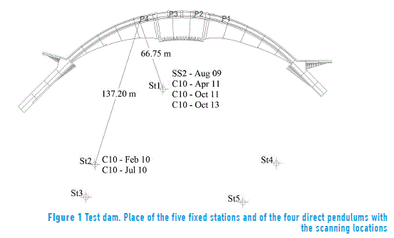
They were available 3D point clouds of three campaigns carried out with "Leica Scanstation C10" TLS equipment in spring 2011 and fall 2011 and 2013 respectively, at the dam under study, arch gravity type. Additionally, there were available other meshes from three other previous campaigns carried out in summer 2009 and winter and summer 2010, respectively. The data of 2009 were taken using "Leica Scanstation 2" equipment and the ones of the two other campaigns using "Leica Scanstation C10" equipment. In the dam studied, there are four direct pendulums and two DGPS stations making them ideal for the purpose intended. In turn, there are five fixed stations georeferenced and sited in concrete pillars, founded on solid rock. Figure 1 shows a schematic plan drawing of the dam with the position of the pendulums and the position of the fixed stations on the downstream slopes and the position of equipment in each of the campaigns mentioned [11].
In the analysis of the results of this work, the findings of the study about equipment characterization and the design of data acquisition campaigns in real cases, already mentioned [10], have been taken into account. In that study, a graphic pattern dispersion/precision is proposed from which ranges of values of "distance-beam incidence angle" can be obtained to ensure precision values below a certain value. This graph was made for the "Leica ScanStation C10", resulting precisions below 2 mm and accuracies below 4 mm for distances less than 130 meters and angles of incidence with the tangent to the wall of the dam greater than 50 centesimal degrees. The average distance in the point cloud was 6 mm and the average size of the triangles of the generated meshes of 25 mm. Seasonal radial movements recorded in the existing pendulums have reached 40 mm [11]. Analyzing values from movements given by pendulums and the movements from the meshes, differences bellow 4 mm are shown. That results show that this methodology is suitable to be applied in this kind of studies. The approach consists of measuring the distances of the meshes to one, taken as reference, and assuming the same movements as those derived from the records of the pendulums. The supposed movement to the reference mesh, increased by the differences with the other meshes, gives the movements of the dam in the respective dates.
Based on Figure 1 and the conclusions of the study [10], it was expected to obtain differences below 4 mm between the movements given by the pendulums and the ones obtained from the point clouds of the last three campaigns. It was enough making a single station to cover the whole facing of the dam which is certainly important because it reduces the time for data collection and also eliminates some part of the back office work: the recording of 3D point clouds taken from different stations.
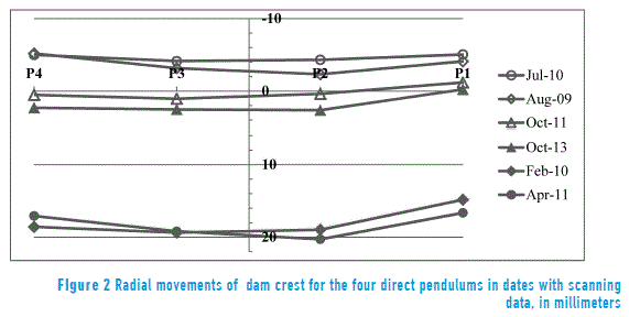
It was decided to take, as the reference mesh, the corresponding to the April 2011 campaign, because it is the one that corresponds to the largest movements given by the pendulums (Figure 2). In this figure, the vertical axis corresponds to the axis of the dam and the abscissa represents, schematically, the position of the four direct pendulums. Positive values indicate downstream movement. The movements given by the pendulums, in February 2010, are very similar to those of April 2011; however, the quality of the scanning data was less reliable because they were made from a faraway location, with distances to the facing of the dam above the limit of 130 meters.
An important aspect to be considered is the density and regularity of the point cloud. In order to get the point cloud more regular as possible, it should be considered which option is better: performing a scanning all at once or by blocks. The scanning is controlled by the computer, i.e., the device configures itself in order to obtain a network of points to a given equidistance. The equipment have to determine the horizontal and azimuthal angular increment to get the given equidistance; but only two separate increments, one for each direction, are calculated for a scanning, corresponding to a reference distance of the scanned area. For example, assuming the nearest point is at a distance of 100 m and the equidistance in the point cloud of 7 cm, the angular increment for the identification of the points of the cloud would be 7.0x10⁻⁴ radians. If the distance to the farthest point were 250 m away, the equidistance among the points in the network at the ends of the cloud would be 17.5 cm. To prevent this dispersion, the scanning from a station is done by sectors, defined by an angular path and a reference distance, so that the offset dispersion does not exceed a maximum. The sectors do not overlap the start angle of a sector coinciding with the end angle of the previous sector.
Regarding the point density of the clouds, it is desirable that all are similar and even more that the triangles size, in all meshes, are similar. This problem happened with the meshes of the first three campaigns in which the average size of the triangles was 90 cm while in the meshes of the last three campaigns was 20 cm.
Measuring distances between pairs of meshes is done from the nodes of the meshes, usually from the nodes of the mesh of reference. The 3DReshaper program works like this and it was used in this study.
Figure 3 shows the direct output of 3DReshaper corresponding to the measurement of distances between the reference mesh (April 2011) and the one of October 2013. Positive values indicate upstream movement and distances are grouped into five intervals differentiated by solid colors. The percentage of points that are in each interval is also shown.
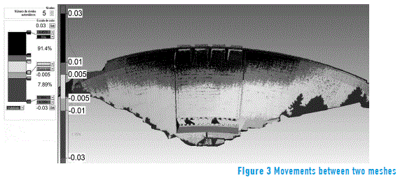
This is the most important contribution of data processing provided by TLS equipment, an almost continuous and complete model of the movements of a dam from real data, with a density of points, good enough, to be applied in this kind of studies.
From here, any planar section can be obtained, either from the 'distances/movements' meshes, or from the meshes, which represent the position. In Figure 3 the vertical construction joints, interesting construction elements to obtain sections, can be observed.
3. Data processing and results
3.1. CAD data Integration with the point clouds
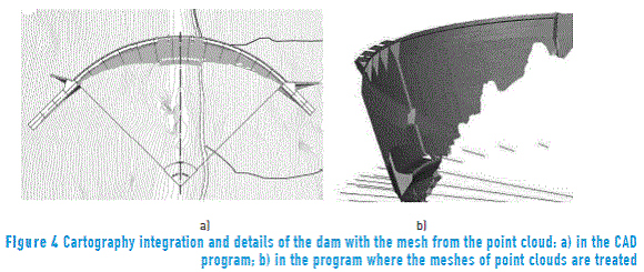
Site maps of the dam, with constructive details in the local coordinate system of the dam, were available. This coordinate system was used for setting up the equipment so that the integration, of both data sets, was not too difficult. In Figure 4 the result of such integration is shown, in both systems used, in the CAD program and in the one used for the treatment of the meshes. In Figure 4a, the solid grey area is the triangle mesh imported from the point clouds program. The information transfer from one program to another was made with dxf files. In Figure 4b, the four radial lines of the arc of the dam corresponding to the position of the direct pendulums are shown. These lines were used for obtaining the mesh sections by vertical planes.
3.2. Getting the movements of the dam based on distances between meshes and their comparison with the radial movements of the pendulums
Direct pendulums do not give absolute but relative dam crest movements respect to the base of the pendulum. Therefore, two data corresponding to the differences between meshes, in each section of the vertical planes of the pendulums, were taken. These mesh sections were also obtained by two horizontal planes, at height of the pendulum in the dam crest and at the height of the base of the pendulum. In Figure 5, the result for one of the meshes of the process described is shown.
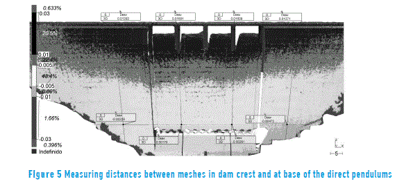
Table 1 shows values obtained comparing distances to the reference mesh (Apr-2011) at the pendulums location, at dam crest and at base of these. Positive values indicate upstream movement.
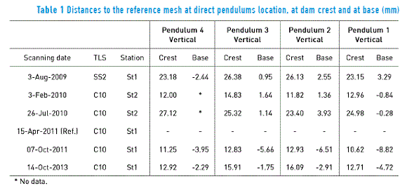
Movements of the direct pendulum are relative to a time origin, when it starts being operated. However, regarding point clouds there are not data for that initial time, in most cases. The only possibility, in order to compare the point clouds, would be to have a topographic survey of the situation of the dam at an earlier time to the scans. Based on that topographic survey, a reference mesh could be generated. As there are not such data, a suitable time origin must be chosen and refer to it all scans carried out. In this study, it was taken as time origin the corresponding one to the scanning performed in April 2011 with the "Scanstation C10", at St1 base (Figure 1). The pendulums movement assigning, at the same date, allows the dam crest movements to be calculated at the same dates as the data obtained with the TLS and to compare them with those of the pendulums.
It was considered, as equivalent data to the one given by the direct pendulum, the relative movement between mesh points in the vertical plane of each pendulum, between the base of the pendulum and the dam crest. Radial movement recorded by the pendulums and movement obtained from TLS data, as explained in the above hypothesis, are shown on a time scale in Figures 6 to 9. Radial movements of the pendulums at dam crest are represented with solid line, except for the last data of October 2013 in which the continuity of the line is broken due to the large span of time to the previous campaign. The points obtained from differences of the meshes are represented as isolated points to highlight the differences with pendulum data.
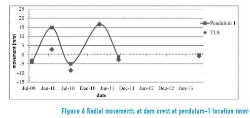
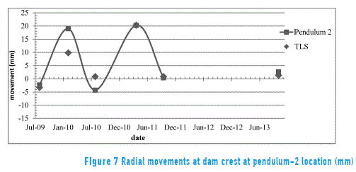
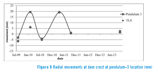
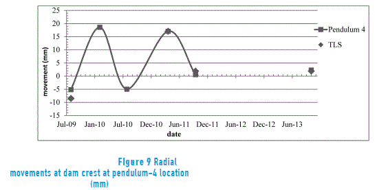
The results are very encouraging and invite to continue making new tests with other dams to confirm these results. As summary, in Table 2, for each campaign, the deviations of the values deduced from the meshes generated by the point clouds, the average of the four data and the standard deviation are shown.
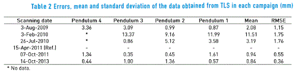
It is confirmed that the data of the last three campaigns, which have been all taken from base St1 and with triangles of meshes of similar average size, have differences bellow 2mm. For the first three campaigns, the equipment used was an older model, but with similar characteristics to the latest one. Additionally, it is important to take into account that the average size of the triangles from the mesh of the first campaign is about 90 cm, bigger than the triangles of the meshes of the last three campaigns, about 20 cm.
The worst data correspond to the 2nd and 3rd campaigns, in which the equipment were stationed at a farthest base and besides the average sizes of the triangles was about 90 cm. The equipment used in these two campaigns was the "Scanstation C10" as in the last three. We must emphasize the need to generate meshes with a similar triangles size. Differences between February and July campaigns with the others can be explained because of the influence of distance and angle of incidence of the beam. The same can be said about the differences between the four positions of the pendulums in the same campaign, which is currently under study. An advance was presented in the study of 2013 [10].
4. Conclusions
The results are very encouraging. Differences, between the movements resulting from the comparison among meshes and the recorded movements with the direct pendulums, have been about 1 mm.
As the direct pendulums give information about dam movements, relative to a zero reference date, a reference mesh, in order to be available to compare with the other meshes, has to be set. This reference mesh should be obtained with topographic methods accurate enough. Those meshes, as we have seen, can be generated from 3D point clouds scanning.
Differences in precision and accuracy in the various campaigns stress the need for a clear methodology in performing the scanning and the generation of meshes during post-processing.
It is important, firstly to determine the stationing of the equipment according to the distances and incidence angles and established precisions, and secondly to choose point densities and meshes size correctly, in order to be able to carry out comparison between meshes. The values used in the latest campaigns which have served for this study, were 7 cm distance between points and average triangles size of the mesh 20 cm. Those values have given good results.
5. Acknowledgements
We would like to thank Rodrigo García, Jesús Bonet y Angel Herranz of Leica Geosystems by the technical, field work and data processing in the case study.
We also like to thank David Galán, Canal de Isabel II - Comunidad de Madrid, because of his help for the acquisition of field data of the dam, used in this study which was essential.
6. References
1. Y. Reshetyuk. Investigation and calibration of pulsed time-of-flight terrestrial laser scanners. Licentiate Thesis, Royal Institute of Technology. Stockholm, Sweden. 2006. pp. 1-152. [ Links ]
2. H. Ingensand. Metrological aspects in terrestrial laser-scanning technology. Proceedings of 3rd IAG Symposium of Geodesy for Geotechnical and Structural Engineering and 12th FIG Symposium on Deformation Measurements. Baden, Austria. CD-ROM. 2006. pp. 1-10. [ Links ]
3. T. Schulz. Calibration of a terrestrial laser scanner for engineering geodesy. PhD Thesis, ETH Zürich. Zürich, Switzerland. 2007. pp. 1-172. [ Links ]
4. E. Heine, H. Reiner, J. Lerma, J. Biosca, T. Weinold. 3D risk mapping: preparing learning material on the use of laser scanning for risk assessment of public infrastructure. European Leonardo Da Vinci Program, International Workshop on the application of terrestrial laser scanning for risk mapping. Valencia, Spain. CD-ROM. 2007. pp. 77-87. [ Links ]
5. A. Chrzanowski, A. Szostak, R. Steeves. Reliability and efficiency of dam deformation monitoring schemes. Proceedings of the CDA 2011 Annual Conference. Fredericton, NB. Canada. October 15-20. CD-ROM. 2011. pp. 1-15. [ Links ]
6. J. de Luis. Contraste en la ejecución de auscultaciones geodésicas por métodos clásicos y con láser escáner. Doctoral Thesis, University of Cantabria. Cantabria, Spain. 2009. ISBN: 9788469329283. pp. 1-719. [ Links ]
7. J. Rüeger. Overview of geodetic deformations measurements of dams. Proceedings of the Australian National Committee on Large Dams Conference (ANCOLD). Sydney, Australia. 2006. pp. 1-34. [ Links ]
8. D. Schneider. Terrestrial laser scanning for area based deformation analysis of towers and water damns. Proceedings of 3rd IAG Symposium of Geodesy for Geotechnical and Structural Engineering and 12th FIG Symposium on Deformation Measurements. Baden, Austria. CD-ROM. 2006. pp. 1-10. [ Links ]
9. M. Alba, L. Fregonese, F. Prandi, M. Scaioni, P. Valgoi. "Structural monitoring of a large dam by terrestrial laser scanning". IAPRSSIS. Vol. 36/5. 2006. pp. 1-6. [ Links ]
10. L. Ramos, M. Marchamalo, R. Martínez, J. Rejas. "Aplicación del Láser Escáner Terrestre (TLS) a la modelización de estructuras: precisión, exactitud y diseño de la adquisición de datos en casos reales". Informes de la Construcción. Vol. 67. 2015. pp. 1-9. [ Links ]
11. D. Galán, M. Marchamalo, R. Martínez, J. Sánchez. "Geomatics applied to dam safety DGPS real time monitoring". International Journal of Civil Engineering. Vol. 11. 2013. pp. 134-141. [ Links ]
