


Services on Demand
Journal
Article
 English (pdf)
 Article in xml format
 Article references
 Send this article by e-mail
Indicators
-
 Cited by SciELO
 -
 Access statistics
Related links
-
 Cited by Google
 -
 Similars in
SciELO
Similars in
SciELO -
 Similars in Google
Share

 Permalink
Agronomía Colombiana
Print version ISSN 0120-9965
Agron. colomb. vol.33 no.3 Bogotá Sep./Dec. 2015
https://doi.org/10.15446/agron.colomb.v33n3.53760
Doi: 10.15446/agron.colomb.v33n3.53760
1 Department of Civil and Agricultural Engineering, Faculty of Engineering, Universidad Nacional de Colombia. Bogota (Colombia). jhcamachot@unal.edu.co
2 La Libertad Research Center, Corporacion Colombiana de Investigacion Agropecuaria (Corpoica). Villavicencio (Colombia).
Received for publication: 24 June, 2015. Accepted for publication: 17 November, 2015.
Abstract
The need to increase the yield and thus the income of farmers and provide food for the growing population requires the search for more efficient and innovative ways for growing, such as management by zones or site-specific practices. This knowledge improves the process of decision making in agricultural production for better crop management. The aim of this study was to determine zones of agricultural management based on corn yield and its relationship with some physical attributes in an Oxisol on the Eastern plains of Colombia. For this, the soil sampling was done in a regular grid whose sampling points were spaced every 70 m, in an area of 37 ha. The studied soil attributes were penetration resistance (PR), texture, total porosity (TP), macropores, mesopores, micropores, saturated hydraulic conductivity (KS), bulk density (BD), particle density (PD), soil water content (SW) and yield. The results were analyzed using descriptive statistics, geostatistics and multivariate techniques. From these results, management zones were defined. The soil physical attributes presented high variability in the different regions of the sampled area. The methods used for characterizing the management zones, allowed for identifying which area presented the best physical characteristics, an area that also showed the highest production of maize, similar in the different methods that were studied.
Key words: soil management, Zea mays L., spatial distribution, precision agriculture, oxisols, Eastern Plains.
Resumen
La necesidad de aumentar el rendimiento y con ello los ingresos de los productores agropecuarios, así como abastecer de alimentos a la creciente población, obliga a la búsqueda de prácticas más eficientes e innovadoras para cultivar, como el manejo por zonas o por sitio específico. Estas prácticas permiten mejorar el proceso de toma de decisiones en la producción agrícola, para una mejor gestión de los cultivos. El objetivo de este estudio fue determinar zonas de manejo agrícola basadas en el rendimiento de maíz y su relación con algunos atributos físicos, en un Oxisol de la altillanura plana de Colombia. Para esto, el muestreo del suelo se realizó en una malla regular cuyos puntos de muestreos se encontraban distanciados cada 70 m, en un área de 37 ha. Los atributos del suelo estudiados fueron resistencia a la penetración (PR), textura, porosidad total (TP), macroporos, mesoporos, microporos, conductividad hidráulica saturada (KS), densidad aparente (BD), densidad de partículas (PD), contenido de agua del suelo (SW) y la producción del cultivo. Los resultados fueron analizados mediante estadística descriptiva, geoestadística y técnicas multivariadas. A partir de estos resultados se definieron zonas de manejo. Los atributos físicos del suelo presentaron alta variabilidad en diferentes sectores del lote muestreado. Los métodos empleados para la caracterización de las zonas de manejo, permitieron identificar cual es la zona que presentó las mejores características físicas, zona que también presentó la mayor producción de maíz, similar en los diferentes métodos estudiados.
Palabras clave: manejo del suelo, Zea mays L., distribución espacial, agricultura de precisión, oxisoles, Llanos Orientales.
Introduction
Corn (Zea mays L.) is the third largest crop in the world, after rice and wheat crops. Production and consumption present great economic and social importance, both for humans and animal feed, as well as raw materials for industrial uses (Galvão et al., 2014). In Colombia, more than half a million hectares are planted, whose production depends on the crop management system. The regions with high production are Córdoba, Tolima and Meta, with yields that exceeded 5 t ha-1 for the 2013 harvest (MADR, 2014), lower than yields recorded in subtropical areas.
One reason for this low productivity is due to conventional management with a random sampling of low density that is insufficient to express the relationships between soil attributes and crop productivity, sometimes leading to errors in decision making, as they may present large variations of the same attribute due to changes caused by agricultural activities (Strudley et al., 2008; Sánchez et al., 2011).
Moreover, farmers generally consider the chemical attributes for management, ignoring the importance in managing the physical attributes. According to Letey (1985), the physical attributes related to soil productivity can be divided into two categories: those directly related to the development of the plant (water, oxygen, penetration resistance and temperature, among others) and those whose relationship is indirect, such as the texture, aggregation, porosity and density.
Physical attributes play a key role in fertility and are a basic component of soil quality (Amézquita et al., 2004), and their evaluation has been recommended to define specific management units (Cucunubá-Melo et al., 2011; Camacho-Tamayo et al., 2013).The bulk density is known as a parameter which gives indications of the presence of compacted areas because a reduction in the soil porosity causes an increase in the BD value (Orjuela-Mata et al., 2011) since actual density (Dr) is linked with the type and amount of mineral and organic soil constituents and sedimentation rate of particles (Orjuela-Matta et al., 2011). The true density and bulk density have a predominant role in the total porosity and therefore the movement and storage of water in the soil (Cruz et al., 2010). Furthermore, clays contribute to the stabilization of organic carbon and the retention of anions and cations in the soil, which affect the processes of percolation and the stripping/retention of nutrients, as well as the agrochemicals in the soil (Godwin and Miller, 2003).
Frequently, the analysis of this information is performed by univariate techniques that only allow for characterizing the soil properties. Therefore, it requires a great number of measurements at different sites to obtain an accurate estimate. For the analysis of data thus created, the use of geostatistical tools that allow for the evaluation and understanding of the spatial variability of soil variables is suggested (Martins et al., 2011), considering the response to problems such as variability of the soil properties and the relationship with the climatic conditions (Navar and Lizarraga-Mendiola), variability in physical properties (Cruz et al., 2010) or determination of management units and analysis of crop yield (Camacho-Tamayo et al., 2013).
A multivariate analysis reveals the associations among a group of studied properties. Cluster and principal component analyses are employed for classification, mathematical modelling, and evaluation in environmental studies. In soil property studies, a multivariate analysis allows for the characterization of an area and the identification of the interaction with the surroundings of each resulting property and group. While it is true that these methods do not in themselves allow for the establishment of the spatial variability of a group of samples, they support their categorization and grouping. With this grouping, it is possible to determine areas and establish management zones allowing appropriate uniform management to be carried out within the zones (Camacho-Tamayo et al., 2013).
The objective of this study was to define the relationship between some physical attributes with crop yield of corn in an Oxisol and to identify management zones (MZ) in order to generate recommendations and improve agricultural practices.
Materials and methods
The study was conducted in the municipality of Puerto López (Meta) on the Versalles farm, with the geographical coordinates 4°09'51.31 N and 72°48'38.86 W, at an altitude of 232 m a.s.l. The soil of the study area was classified as a Typic Haplustox, with maize crop. The experimental unit had an area of 37 ha. The zone has a sub-humid tropical climate with an average temperature of 27.8°C and an annual precipitation between 2,200 and 2,400 mm, which is concentrated between the months of April and November.
In each sampling point, undisturbed samples at 0-10 cm and 10-20 cm depths were taken for the determination of the physical properties such as total porosity (TP), macropores (MAP), mesopores (MEP), micropores (MIP), bulk density (BD), particle density (PD) and saturated hydraulic conductivity (KS). The soil water content was determined with the gravimetric technique and the texture was determined with the Bouyoucus method. In a field, the penetration resistance (PR) to 0.60 m depth was measured with an Eijkelkamp Penetrologger, with a soil water content near to the field capacity due to precipitation at sampling time (November). At the end of the crop cycle (December 2012), the production parameters were obtained.
With the experiment data, initially, a descriptive statistical analysis was performed to determine the mean, median, maximum and minimum coefficients of variation (CV), skewness and kurtosis. Thus, the adjustment to normal for each variable was verified (Diggle and Ribeiro, 2000). For the analysis of CV, Warrick and Nielsen (1980) was used, which considered low variability for CV below 12%, middle variability between 12 and 60% and high variability for CV greater than 60%.
To define the management zones (MZ), three methods were used. The first method was the cluster analysis, while the second and third methods were related to estimating the soil index (SI) with two different methods: principal component analysis (CPA) and the coefficient of variation (CV). A SI corresponds to a linear combination of the properties of the selected soil where the weight of each property is chosen. A description of the SI is given by Ortega and Santibañez (2007). Cluster analysis identifies groups of observations that have some similarities to each other (Ferreira, 2011). After the areas of handling for each method were identified, plots of MZ were developed. Finally, the Pearson correlation between the MZ and each attribute was estimated to establish the correlation and influence of the attributes in the MZ. For the statistical analysis, SPSS v.20 was used.
Results and discussion
Similar values of the mean and the median in the studied variables suggested a symmetrical distribution of the data, which together with the near-zero coefficients of skewness and kurtosis values, support the conclusion that the behavior of the distributions were near to normal (Tab. 1). This approximation to the normal distribution, expressed by the skewness and kurtosis, resulted in increased reliability because the variance was more stable (Camacho-Tamayo et al., 2013).
The observed values of PR at the 0-10 cm depth were lower than those reported for the Colombian Eastern Plains by Rubiano (2005) and Jaimes et al. (2003), which reported values between 1.73 and 3.37 MPa for native savanna. This shows that the soil intervention by agriculture reduces the PR in the shallow layers. On the other hand, at the depth of 10-20 cm, a mean of 1.98 MPa was observed for the PR, value, considered by several authors as appropriate, at the upper limit for the root development of plants (Hamza and Anderson, 2005; Medina et al., 2012). The PR for the 10-20 cm depth, as determined by Warrick and Nielsen (1980), showed low variability. For the other studied attributes, the variability was medium with a CV lower than 60; however, the attribute dispersions at the two depths were relatively similar.
According to the sand, silt and clay contents, the soil texture was between clay loam and sandy loam. The bulk density showed values between 1.47 and 1.51 g cm-3 at the depths of 0-10 cm and 10-20 cm, respectively. The TP was similar for the analyzed depths, with values close to 46%.
For the cluster analysis of the soil physical attributes, a Euclidean distance of 15 was used (Fig. 1). For the two depths, four groups were considered. The sand content was correlated with BD because these attributes were in the same group. Likewise, it was observed that the crop yield depended on the PR at both depths. Another characteristic was the relationship between the soil water content (SW) and the MEP, indicating that the soil water availability was subject to the pore size. Moreover, as observed for these attributes in the cluster analysis, the presence of silt also indicated the presence of pores; furthermore, the amount of MAP determined the KS.
The principal components analysis (PCA) presented similar behaviors at both depths (Fig. 2), particularly in the first and second component (PC1 and PC2). Similar results were reported by Camacho-Tamayo et al. (2010) for chemical properties in this Oxisol, with different levels of intervention. For the first depth, the PCA considered three PCs with an engine value above one (1), components that represented more than 70% of the total variance. For the second depth, four components were considered since they represent more than 70% of the total variance. The CP1 represented 43.5 and 45.54% of the total variance for each depth, respectively, where the attributes that best represented this component were silt, clay, TP and MIP, attributes that presented a negative correlation with the first depth and a positive correlation at the second depth. Furthermore, the sand, PD and BD showed a positive correlation at the first depth and a negative correlation at the second depth.
The second component (PC2) represented 19.96 and 15.91%, respectively, of the total variance for each depth, where MAP and KS had inverse correlation for both depths, as observed in the cluster analysis (Fig. 1). At both depths, the more representative physical attributes for CP1 were silt, clay, TP, MIP, sand, PD and BD. The yield had low correlations with these attributes and low representation in the PCA.
The determination of the MZ based on the cluster analysis allowed for the definition of four zones for the first depth (Fig. 3A), with an area of 10.78, 8.33, 14.21 and 3.43 ha, respectively. Zone 1 and 4 had the lower CV values, while zone 3 had the greatest value (Tab. 2).
For the second depth (Fig. 3B), four areas were determined. Zone 1, with 16.66 ha and the largest area, and zone 2, with 3.92 ha, had medium values of CV. Zone 3, with 12.74 ha, and Zone 4, with 3.43 ha, had the higher CV values (Tab. 2). At the studied depths, the PR was high, with values of 1.33 MPa for the first depth and 2.1 MPa for the second depth, which showed the formation of a compact layer. Zone 1 had higher contents of TP and MEP due to a high clay content and a low Da. Zone 2 had a low BD, high TP and moderate Ks at the second depth according to the classification created by Kohnke (1968). Zone 3 had a low BD and high TP, while the four zone presented high MEP values and low contents of MIP. The soil KS behaved randomly with values between slow and fast; however, area 4 had a moderate Ks.
According to the soil index based on the coefficient of variation, the four zones were determined using the physical attributes. Zone 4, with 11.27 ha, had the highest CV value. Zone 2, with 18.13 ha, had the largest area. Zone 1, with 3.92 ha, showed the lowest CV value, and Zone 3, with 11.27 ha, presented medium values (Tab. 3).
At the studied depths, Zone 4 showed a high PR at the first depth and a low PR at the second depth, and a high sand content, low values of BD, MIP, TP and MEP, and a moderate KS at the first depth. This indicates the presence of a compacted layer apparently caused by machinery traffic. Zone 2 had a high PR and MIP and a moderately slow KS according to the Kohnke classification. Zone 3 showed a low BD, moderately slow KS and high MEP (Fig. 4).
According to the soil index based on the principal components analysis (Fig. 5), for the physical attributes at the two depths, the highest CV values were in Zone 4. In contrast, Zone 1 had the lowest CV values. Zones 1 and 2 had approximately similar mean values for PD and MAP although they had different CVs (Tab. 4).
It was observed that the methods of the soil index based on the coefficient of variation and corresponding principal component were similar at both analyzed depths, as with Zone 4, where a high sand content, low values of PR, BD, MIP, TP, MEP and a moderate KS value were observed. Zone 2 showed a high PR and MIP and a moderately slow KS. In this zone, the use of a chisel plow is recommended to till the compacted layer to prevent limitations on root development, as seen in reports by Ramírez-Lópezet al. (2008) for compacted soils of this zone. Zone 3 presented a low BD, moderately slow KS and high MEP. Moreover, Zone 1 had a high TP and low BD.
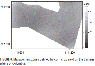
The zone delineation for the crop yield was established on the basis of coefficient of variation, with four management zones (Tab. 5 and Fig. 6). The zone with the lowest production was Zone 1 (4.96 t ha-1) and Zone 4 (7.51) was the zone with the highest yield, in an area of 5.88 ha. By correlating these areas with the physical attributes, it appears that the zone of greatest yield presented the highest values of sand and MIP, low values of PR and BD and a moderate KS. Moreover, Zones 1, 2 and 3 showed high values of TP and MEP.
According to the above, the best physical conditions were present in Zone 4 and the other zones must be enhanced in order to improve the soil conditions and increase yield. For this, the use of a chisel plow is recommended to break the compact layer and cause soil fractionation. Thus, different attributes, such as infiltration, air capacity, distribution of nutrients and root penetration, will be improved (Molina et al., 2003).
Conclusions
This spatial variability allowed for the establishment of management zones, where it was possible to identify the best area based on the physical characteristics and yield crop by different methods, which showed similarity in their results. The overall relationship, including data from all of the sites, between the methods of delineation was very high. In practice, this means that, once the proper attributes that explain yield are identified, any of the evaluated methods could be used to delineate the MZ within a field. Likewise, with this information, better management of different areas is facilitated in order to increase crop production.
Literature cited
Amézquita, E., R.J. Thomas, I.M. Rao, D.L. Molina, and P. Hoyos. 2004. Use of deep-rooted tropical pastures to build-up an arable layer through improved soil properties of an Oxisol in the Eastern Plains (Llanos Orientales) of Colombia. Agric. Ecosyst. Env. 103, 269-277. Doi: 10.1016/j.agee.2003.12.017 [ Links ]
Camacho-Tamayo, J.H., C. Luengas-Gómez, and F.R. Leiva. 2010. Análisis multivariado de propiedades químicas en Oxisoles con diferentes niveles de intervención agrícola. Acta Agron. 59, 273-284. [ Links ]
Camacho-Tamayo, J.H., Y. Rubiano-Sanabria, and L.M. Santana. 2013. Management units based on the physical properties of an Oxisol. J. Soil Sci. Plant Nutr. 13, 767-785. Doi: 10.4067/s0718-95162013005000061 [ Links ]
Cruz, J.S., R.N. Assis Júnior, S.S.R. Matias, J.H. Camacho-Tamayo, and R.C. Tavares. 2010. Spatial analysis of physica l attributes and organic carbon from yellow-red alfissol with sugarcane crop. Ciênc. Agrotec. 34, 217-278. Doi: 10.1590/S1413-70542010000200001 [ Links ]
Cucunubá-Melo, J.L., J.G. Álvarez-Herrera, and J.H. Camacho- Tamayo. 2011. Identification of agronomic management units based on physical attributes of soil. J. Soil Sci. Plant Nutr. 11, 87- 99. Doi: 10.4067/S0718-95162011000100008 [ Links ]
Diggle, P.J. and J.R. Ribeiro. 2000. Model based geostatistics. Associação Brasileira de Estatística, São Paulo, Brazil. [ Links ]
Ferreira, D.F. 2011. Estatística multivariada. 2nd ed. Editora UFLA, Lavras, Brazil. [ Links ]
G alvão, J.C.C., G.V. Miranda, E. Trogello, and R. Fritsche-Neto. 2014. Sete décadas de evolução do sistema produtivo da cultura do milho. Rev. C eres 61, 819-828. Doi: 10.1590/0034-737x201461000007 [ Links ]
Godwin, R.J. and P.C.H. Miller. 2003. A review of the technologies for mapping within-field variability. Biosyst. Eng. 84, 393-407. Doi: 10.1016/S1537-5110(02)00283-0 [ Links ]
Hamza, M.A. and W.K. Anderson. 2005. Soil compaction in cropping systems: a review of the nature, causes and possible solutions. Soil Till. Res. 82, 121-145. Doi: 10.1016/j.still.2004.08.009 [ Links ]
Jaimes, W., G. Navas, C. Salamanca, and A. Conde. 2003. Estudio detallado de suelos de la estación experimental de Corpoica "Sabanas" en la Altillanura Colombiana. Corpoica, Villavicencio, Colombia. [ Links ]
Kohnke, H. 1968. Soil physics. Mc Graw-Hill Book, San Francisco, CA. [ Links ]
Letey, J. 1985. R elationship between soil physical properties and crop production. Adv. Soil Sci. 1, 277-294. Doi: 10.1007/978-1-4612-5046-3_8 [ Links ]
MADR, Ministerio de Agricultura y Desarrollo Rural. 2014. Anuario estadístico del sector agropecuario 2013. Oficina Asesora de Planeación y Prospectiva, Grupo de Información y Estadísticas Sectoriales. Bogota. [ Links ]
Martins, A.L.S., E.G. de Moura, and J.H. Camacho-Tamayo. 2011. Evaluation of corn production parameters and their spatial relationship with chemical attributes of the soil. Agron. Colomb. 29, 99-106. [ Links ]
Medina, C., J.H. Camacho-Tamayo, and C.A. Cortes. 2012. Soil penetration resistance analysis by multivariate and geostatistical methods. Eng. Agríc. 32, 91-101. Doi: 10.1590/S0100-69162012000100010 [ Links ]
Molina L., D.L., E. Amézquita C., and P. Hoyos G. 2003. Construcción de capas arables en suelos oxisoles de la Altillanura Colombiana. pp. 113-117. In: Evaluación de parámetros y procesos hidrológicos en el suelo. VII Escuela Latinoamericana de Física de Suelos. La Serena, Chile. [ Links ]
Navar, J. and L. Lizarraga-Mendiola. 2014. Tree-ring growth and hydro-climatic variability in temperate dendrochronologies of northern Mexico. Agron. Colomb. 32, 103-112. Doi: 10.15446/agron.colomb.v32n1.41271 [ Links ]
Orjuela-Matta, H.M., Y. Rubiano-Sanabria, and J.H. Camacho-Tamayo. 2011. Spatial variability of hydrodynamic parameters in the native savanna of the Colombian Eastern plains. Agron. Colomb. 29, 83-90. [ Links ]
Ortega, R.A. and O.A. Santibáñez. 2007. Determination of management zones in corn (Zea mays L.) based on soi l fertility. Comput. Electron. Agric. 58, 49-59. Doi: 10.1016/j.compag.2006.12.011 [ Links ]
Ramírez-López, L., A. Reina-Sánchez, and J.H. Camacho-Tamayo. 2008. Variabilidad espacial de atributos físicos de un Typic Haplustox de los Llanos Orientales de Colombia. Eng. Agríc. 28, 55-63. Doi: 10.1590/S0100-69162008000100006 [ Links ]
Rubiano, Y. 2005. Sistema georreferenciado de indicadores de calidad del suelo. Herramienta SIG para apoyo, planificación, uso y manejo del suelo. PhD thesis. Faculty of Agricultural Sciences, Universidad Nacional de Colombia, Palmira, Colombia. [ Links ]
Sánchez, J.D., G.A. Ligarreto M., and F.R. Leiva. 2011. Spatial variability of soil chemical properties and its effect on crop yields: a case study in maize (Zea mays L.) on the Bogota Plateau. Agron. Colomb. 29, 465-474. [ Links ]
Strudley, M.W., T.R. Green, and J.C. Ascough II. 2008. Tillage effects on soil hydraulic properties in space and time: state of the science. Soil Till. Res. 99, 4-48. Doi: 10.1016/j.still.2008.01.007 [ Links ]
Warrick, A.W. and D.R. Nielsen. 1980. Spatial variability of soil physical properties in the field. pp. 319-44. In: Hileel, D. (ed.). Applications of soil physics. Academic Press, New York, NY. [ Links ]

