


 English (pdf)
 Article in xml format
 Article references
 Send this article by e-mail
 Cited by SciELO
  Cited by Google
  Similars in
SciELO
Similars in
SciELO  Similars in Google
 Permalink
Introduction
The oil palm crop in Colombia has achieved a significant presence, accounting for approximately 10% of the country's total planted area and 30% of the agro-industrial crops (DANE, 2016; Fedepalma, 2019). This presence calls for the development and permanent update of an inventory of the country's planted areas, since this information could be the cornerstone for adequate planning and ordering of the territories.
From its inception, the Federación Nacional de Cultivadores de Palma - Fedepalma has worked to consolidate and develop a database that provides information on aspects relevant to Colombian agribusiness that includes the delimitation, area, and spatial representation of planted areas that can assist the palmiculture sector in adequate decision-making. Therefore, as a first approach to achieving these objectives, Fedepalma, through the Oil Palm Sector Statistical Information System (SISPA), has periodically compiled data of country wide seed sales as an alternative to an estimation of the planted area. This method leads to certain inaccuracies in the calculation determining the effectively planted area requiring corrections, mainly related to discarded seeds.
Fully aware of this condition, in 2007, Fedepalma, in an agreement with Corporación Colombia Internacional (CCI), completed the first georeferencing study on the area planted with oil palm in the country, creating polygons for around 276,000 ha of the 301,000 ha estimated to be planted. Additionally, in 2009 the Centro de Investigación en Palma de Aceite - Cenipalma, as part of a project funded by the Servicio Nacional de Aprendizaje (SENA), made the first adjustment to the cartographic base developed by the CCI and georeferenced additional areas of the crop that added up to a total 310,000 ha in comparison to the 350,000 ha estimated for that year.
Simultaneously, Cenipalma, as part of several regional phytosanitary information management projects, developed geographic databases that used polygons to represent the planted areas in the areas of the Colombian eastern plains, the Magdalena Medio (Central region), and San Andres de Tumaco (Pacific coast). In 2012, this first stage of data collection required focusing efforts on the planning and design of an information management system that would ensure the storage, administration, and consultation of data from the crop plots, i.e., from a specific cadastre of the areas with palm oil. The cadastre (a public register showing the details of ownership and value of land) corresponds to a land inventory (Kaufmann & Steudler, 1998) and under the new trends of the multipurpose cadastre, the inventory transcends the delimitation of properties and is supported by subsystems that carry out inventories of land uses (Williamson et al., 2014; Ponvert et al, 2015). So, the subsystem called Oil Palm Cadastre (OPC) was conceived, its cornerstone was the "land management paradigm" (Williamson et al, 2014) in which high-quality territorial information was an essential component, using the property cadastre as a methodological framework.
According to Ponvert et al. (2015), most national cadastre information systems store general data that often cannot meet the particular needs of every user. For this reason, it is convenient to propose and create specific subsystems that allow managing information at a larger scale, leading to the creation of cadastre subsystems mainly in rural areas (which, by tradition in the countries, has been characterized for having less detailed sales). In the last decade this need has been framed as Green Cadastres (Zysk et al., 2020). Some examples include the land parcel information system to record crops and manage agricultural subsidies in the European Community (Inan et al., 2010), the Specialized Sugar Cane Registry in Cuba (Samuel & Reyes, 2007; Rojas-Martinez et al., 2014), the Forest Cadastre in Greece (Drosos, 2014), the vineyards cadastre in Romania (Hutanu & Moca, 2010; Hutanu et al., 2016), and the inventory of tea areas in Turkey (Ozcelik & Nisanci, 2016), etc.
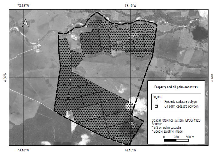
From these initiatives, and taking into account that the cadastre of the property was historically proposed to determine the value of such properties for tax purposes and/or to create a register for the legitimacy of the owners (Alcázar, 2000; Hopfer, 2003), the difference between these subsystems and the cadastre of the property was defined as the fact that the delimitation of the polygons specifically marks the minimum constituent unit of the cadastral subsystem (Samuel & Reyes, 2007; Ozcelik & Nisanci, 2016) and is not carried out considering the property's boundaries (Fig. 1). Therefore, the cadastral subsystems are a complement to this type of cadastre, with the spatial representation as an integrating component (Ponvert et al., 2015).
Therefore, it was important to create a system to store the georeferenced inventory of areas planted with oil palm at a plot scale in Colombia. The primary purpose of this system was to support decision-making in the oil palm industry and to provide updated information about planted areas. The system was developed as a technological tool under the guidelines of a cadastre information system (Çagdas & Stubkjffir, 2011); therefore, this paper describes the OPC conceptualization and the development of a continuously updated system. This tool was proposed as a benchmark for consultation about oil palm plantations in Colombia.
Materials and methods
The system was planned based on "soft systems" theory (Çagdas & Stubkjsr, 2011) to define the elements and actors of the OPC and to define the technical aspects that allowed implementing the OPC based on the system's conceptual framework.
System conceptualization
The OPC system is based on the uncertainty about the actual planted areas and their characteristics and geographic distribution. Therefore, the purpose of elucidating them is to create a theoretical framework through practice (Roux & Barry, 2009).
For this reason, the OPC is conceived as a system and, as such, it has the following characteristics (Wastell, 2012):
Purpose: to provide georeferenced information on areas planted with oil palm as well as associated information in order to make decisions related to the oil palm sector;
Transformation: a collection of geographical data for areas planted with oil palm and data related to the characteristics and management of the crops in order to create information for research, extension, and decision-making;
Feedback cycles: the purpose is to identify the entire planted area of the country; therefore, measurements ensure the fulfillment of its purpose.
However, this is understood as a soft system under systems theory, considering that its purpose as a registry storage system transcends the inclusion of the complexity of human decision-making processes in all its components (Çagdas & Stubkjaer, 2011).
From its inception, the OPC was conceived as a tool whose main actors are Fedepalma, Cenipalma, and palm-growers, interrelated through the collection, storage, and consultation of data on the areas planted with oil palm and the information products generated from them.
A first activity carried out was the definition of the constituent elements of OPC, to break down each of the elements that participate in the definition of the areas with oil palm cultivation. Such a definition is considered a hierarchy determined by spatial units mainly associated with the functionalities and interests of the actors; each unit was assigned characteristics and in turn topological relationships.
Driving the conception of the system towards the operational component, the aspects in which the OPC is transformed from an inventory of areas to functional data were conceived that can be integrated with different sources to consolidate multipurpose characteristics of the inventory.
Technical aspects
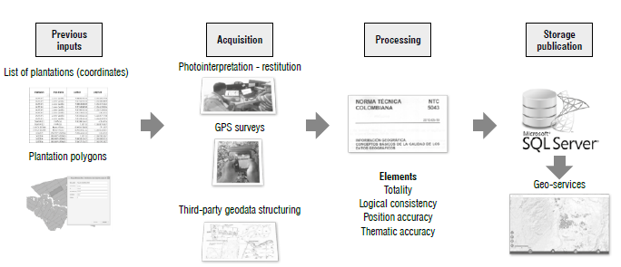
Geographical data sources were classified into three categories: products of photointerpretation, a direct survey with GPS devices, or third-party information available at the plantations. Therefore, a data processing scheme had to be defined to monitor the technical operation of the geographical database construct (Fig. 2). These data structuring aspects were designed considering a detailed revision, correction, and adjustment for the geographical information, based on the Colombian Technical Standard NTC 5043 (ICONTEC, 2010):
• Totality
The list of plots per plantation provided at the beginning of the project was used as a source, understanding that the total polygons must be equal to the number of plots reported for the plantation;
Results and discussion
Elements of the oil palm cadastre
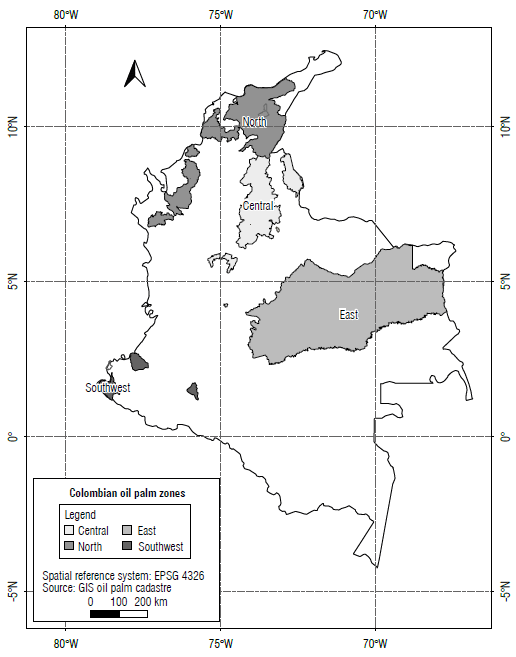
The oil palm crop in Colombia is distributed throughout more than 120 municipalities. The geographic delimitation of what is known in the palm-growing sector as palm-growing areas from an administrative and logistics perspective, were named as follow: north, central, east, and southwest (Fedepalma, 2019) (Fig. 3). These were established based on the surrounding regions that are part of the same geographical region. Similarly, for operationality and accessibility, a group of sub-zones was established within each zone, defined mainly as plantation aggregates. The boundaries of the sub-zones may or may not coincide with the boundaries of municipalities. These sub-zones contained plantations in various rural properties used mainly to grow oil palm, and they are legally owned by one or several people/companies.
Depending on their size, these plantations cover one or several plots (plot being the minimum spatial and administrative division within a plantation) that are usually defined based on homogeneous characteristics of its constituent elements (cultivar, planting date, type of soil, etc.), geographical accidents, or infrastructure works developed inside the plantation. Therefore, it was important to emphasize that an oil palm plantation was a group of plots, which in turn had diverse geographical elements and/or characteristics inherent to them (palms, roads, channels, type of cover, etc.). However, there is no absolute relationship between the property and the plantation, or the property and the plot, because the latter may conform to the entire property, a fraction of it, or the sum of several properties (Sagris & Devos, 2008).
Below are the definitions of the elements that comprise the OPC.
Plot: minimum spatial unit planted with oil palm within a plantation that generally has similar characteristics regarding the planting year and cultivar;
Plantation: set of plots -not necessarily adjacent- grouped under the property and administered by one or several persons (natural or legal);
Sub-zone: Geographical sub-division of the oil palm zones that allow for adequately monitoring the logistics and extension. The boundaries of one sub-zone may or may not coincide with those of the municipalities;
Zone: Geographical division created by Fedepalma to adequately manage the palm productive areas in Colombia. It covers one or more municipalities in one or more departments.
Features of the OPC
The cadastre of the property generally refers to the spatial and legal features (Cagdas & Stubkjsr, 2011). In the case of the OPC, the physical feature of the property refers to identifying and representing geographical elements (plots, plantations, sub-zones, and zones). The agronomic feature refers explicitly to the specification of the cultivar, species, age, phytosanitary status, etc., to describe crop's particularities found in the smallest mappable unit (plot).
Topological relationships
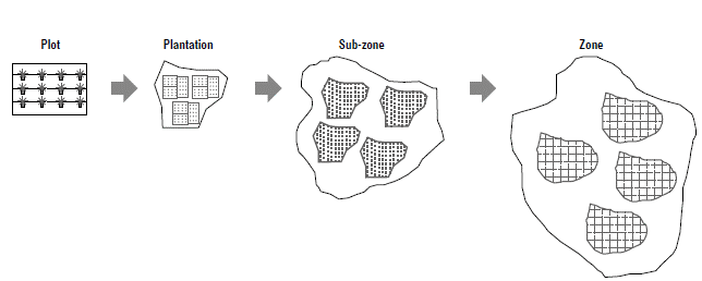
Considering that the fundamental elements of the OPC have geographical representation, topological relationships that establish the hierarchical connections between them had to be defined; i.e., the zone (the element with the highest hierarchy) is formed by various sub-zones that in turn are formed by a certain number of oil palm plantations that cover one or several plots. Figure 4 is a graphical representation of the hierarchical distribution of the elements of the OPC.
Furthermore, defining the relationship of the elements of the OPC with the cadastre of the property allowed integrating new actors to the system. The territorial entities and institutions related to the ordering of the territories considered the information products created by the OPC as inputs. Integrated to the property, the inputs are fundamental for planning and proposing strategies and policies in the territories.
Multi-purpose structure
In a first instance, the OPC was conceived as a solution to quantify the total planted area in Colombia. However, having the geographical conceptualization and representation of the spatial objects allowed integrating another type of strategic information for representation. Therefore, the OPC is currently conceived under a multi-purpose approach that facilitates the integration of agronomic information derived fro crop activities that enhance decision-making criteria.
Therefore, the OPC elements were redefined, considering the possibility of representing phytosanitary and productive variables and the management of crops at a regional scale.
Defining plot boundaries
Considering cadastres of property, an accuracy to the centimeter is essential for urban areas. However, in Colombia, rural cartography has been developed at a maximum scale of 1:10,000, substantially reducing accuracy requirements. However, the material definition of property boundaries in rural and urban spaces is indicative and accurate, e.g., fences of rural properties. However, oil palm plots are generally known for having no explicit physical delimitation. Therefore, the conceptualization included a definition of the plot boundaries, understood as the projection to the ground of the canopies of the palms planted on the edge of the plot.
In practice, under the above definition, the boundary would change as the palm grows; hence, the above concept was complemented with the projection to the ground of the canopies of adult palms, which in practical terms can be extrapolated to half the planting distance between palms.
After defining the concept of plot boundary, it was necessary to specify the minimum accuracy for surveying it. Hence, it was decided that the maximum tolerable error to define the perimeter of a plot would be 10 m, thus tolerating the variation found in the definition of the boundary based on the canopy projection. This allowed including tools such as low-accuracy GPS devices and satellite images with a 5-m resolution and optimized the area surveying works without affecting data quality. As a result, and considering the guidelines set by Tobler (1987), a scale of 1:20,000 was established for the OPC.
Considering that the OPC development aims to provide an approximate quantification of the country's planted area and coordination of the multi-purpose approach, two fundamental components were defined that established the system's objectives and scope. First, approximation to the physical aspect (quantification and geographical representation), and the second inclusion of the agronomic aspect (crop characterization).
Physical aspect
With the first approach, the areas planted with oil palm crops were identified via photointerpretation of satellite images without leading to a definitive demarcation of the plots and plantations (Kelly et al., 1999; Rodríguez et al., 1999; Johansen et al., 2009). The sensors used as data sources were Sentinel 2 and Landsat 8, considering the free access to their data, the multi-temporality, and characteristics for crop discrimination (Sarvia et al., 2020; Jayanth et al., 2022). A future alternative would be support in the delimitation of the plots from satellite image processing techniques, such as fully convoluted networks (KC et al., 2021; Taravat et al., 2021). However, these techniques are still in the research stage and in order to guarantee the quality of the data, human photointerpretation was included in the processing.
The following properties of a plot were established to define the rules of photointerpretation (Stone, 1955): shape, size, structure, texture, and color.
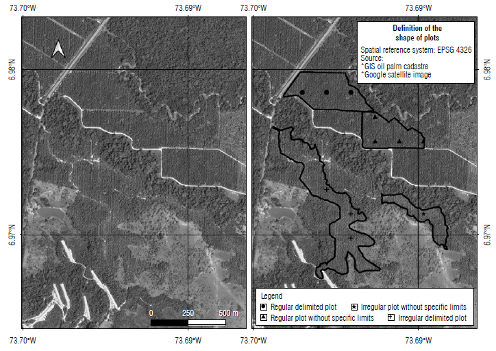
Shape: the plots planted with oil palm are generally known for having regular shapes; however, there are also irregular shapes or shapes defined by administrative considerations that are not related to geographical boundaries (Fig. 5);
Size: generally, an area with oil palm may vary between 1 and 20 ha without identifiable discontinuity like roads or water bodies. However, there may be unusual cases where there are plantations with a larger area;
Structure: the structure inside an oil palm plot must include the presence of staggered formations or planting patterns that form equilateral triangles between palms. However, there may be cases where the plantations do not meet this rule, such as terraced plantations. The presence of irrigation channel infrastructure within the crop may be an indicator of new or young plantations;
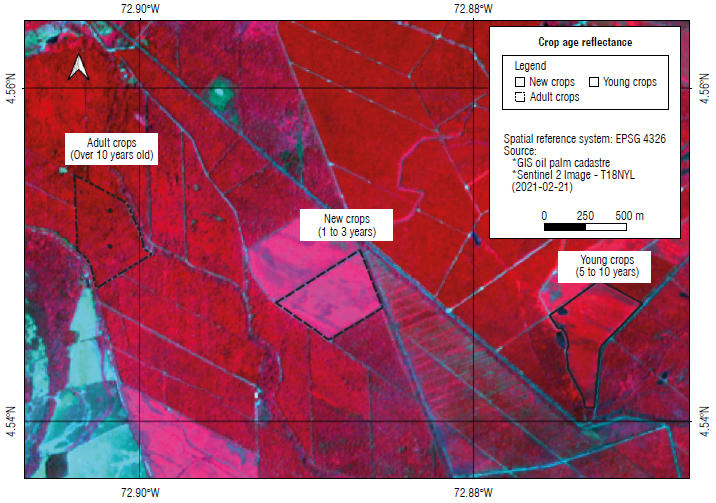
Texture and color: In this case, two closely related properties were addressed, since both are mainly subject to variation in planting age. In high-resolution spatial images, it is possible to distinguish the staggered formation. However, images with a spatial resolution equal to or higher than 5 m required defining a series of keys that facilitate identifying the crops (Fig. 6). However, the similarity between oil palm crops' reflectance with other crops like banana and forests implies field verification.
To establish orderly photointerpretation, a grid of 5 x 5 km2 was defined to cover all the palm areas. Each grid was assigned tracking information to develop the process This series of data traced the area update process. A revision was established for each square, manually employing lateral and vertical displacement, where each of the areas identified as oil palms were restored.
Since the process of updating areas planted with oil palm is carried out every six months, management of the grid data was established as an additional component in the OPC database, making it possible to keep track of the revisions made in the same quadrant over time and identify potential areas for updating.
Agronomic feature
This corresponded to characterization of the minimum agronomic administration unit of the plantations, commonly called a plot. In the absence of a standard for the definition of plot limits, each plantation was autonomous to define its plots, and it was necessary to define the plot as the minimum grouping of palms to which production data, phytosanitary, etc., were recorded. In most cases, plots contained palms from the same planting year, the same cultivar, and had physical limits. In this way, the agronomic feature defined the geometry of the plots in accordance with the administration of the plantation and complemented the data on the following: number of palms, planting density, cultivar(s), planting year and net area.
This feature required greater efforts and dedication, as it demanded establishing direct contact with the owners, managers, or directors of the plantation through palm clusters (oil palm mills). The bonds of trust between clusters and palm growers allowed access to the plantations and access to truthful data.
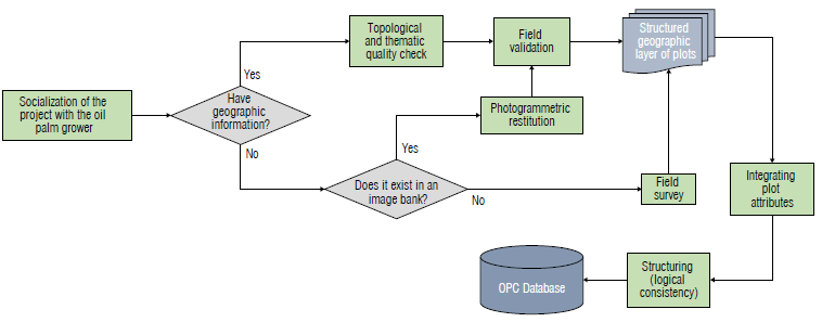
The contact with the commercial liaison between the clusters and the palm growers, the Technical, Environmental and Social Assistance Units (UAATAS) adopted in 2008 (Fedepalma, 2009) enhanced the palm-grower contact strategy because the clusters were receptive to considering the importance of georeferencing planted areas at a plot scale. Below is the process scheme designed for the correct management and collection of plantation cadastral information (Fig. 7).
Finally, the National Oil Palm Cadastre Database is integrated in two stages:
Inclusion of geographical data (physical feature), with semi-annual update;
Association of the agronomic information with each plot (agronomic features), which is a permanent process.
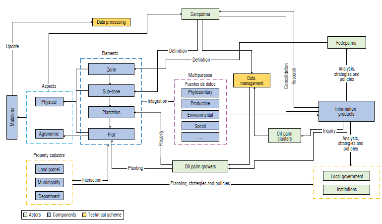
With the inclusion of technical considerations, a new actor became evident in the OPC system that had not been contemplated in the initial formulation. Hence, the palm tree clusters appeared as a determining factor in the process of formation and as a consumer of the information. Thus, finally, the formalization of the processes oriented to management and processing of the data finally consolidated the model of the Oil Palm Cadastre System (Fig. 8).
Information technologies artifacts
A spatial database was designed and implemented in Microsoft SQL Server Database Management System to store spatial and alphanumeric data. This allowed elimination of redundancy allowing capability for data processing, analysis, visualization and exchange (Dawidowicz et al., 2020). The spatial database on the SQL Server was integrated into the ArcServer platform to develop geoservices aimed at publishing the OPC information on the internet: https://geopalma.cenipalma.org
The main developed geoservice consolidates the values of planted areas at a municipality scale and was an example of the interaction between the OPC and territorial units such as municipalities (Fig. 9).
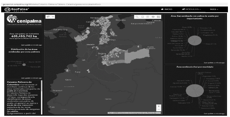
FIGURE 9 Geoservice developed for consultation of data for the oil palm cadastre (in Spanish; https://geopalma.cenipalma.org/M%C3%B3dulos/Catastro-Palmero/Tablero-Catastro/geoserviciocatastrofisico).
Progress in the consolidation of information
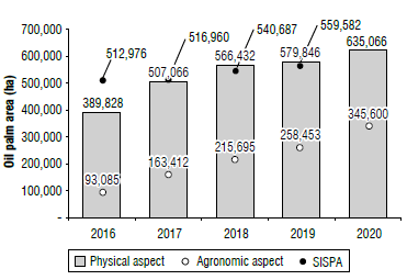
As mentioned above, the work of the Corporación Colombia Internacional (CCI) in 2007 is considered the foundation of the OPC. Throughout 10 years, about 100% of the estimated area planted with oil palm in the country has been georeferenced. This physical feature has had continuous revision (a review of the areas is carried out every two years) parallel to the expansion of the crop, beginning from about 276,000 ha georeferenced in 2007 to 625,066 ha in 2020, exceeding the area reported by the SISPA. Regarding the progress of the agronomic feature, though it is slower it increased from zero hectares in 2007 to 160,000 ha in 2017. Thus, the speed of this (agronomic) feature increased during the last three years, mainly due to the active participation and strong interest of palm growers during OPC development (Fig. 10). As of 2020, there were a total of 625,066 ha in physical terms, of which 345,600 ha are fully characterized physically and agronomically.
Progress in the above features depended on the conditions of each region, with sub-zones such as South Cesar, South Bolívar, Acacias or Fundación mostly able to consolidate their agronomic aspect due to the integration and participation of the oil palm clusters of the sub-zones.
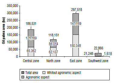
The physical feature has enabled accurately identification of the extent of oil palm trees in each of the palm-growing areas (Fig. 11). To date, the eastern zone has about 46% of the country's total.
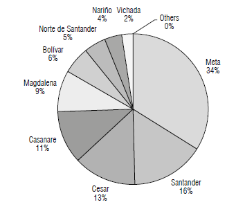
One of the most interesting results has been the possibility of consolidating data at a territorial unit scale, such as departments (Fig. 12). This data was previously estimated without the OPC. As of 2017, the department with the largest planted area of the country is Meta, followed by Santander and Cesar, reiterating that the Eastern and Central palm growing areas have the country's most extensive planted areas.
Conclusions
From a soft systems perspective, the OPC system model allowed including the complex interactions between actors. This was translated into a significant advance in the consolidation of the system's information. Incorporating the palm clusters and growers as active actors accelerated data collection and guaranteed continuous feedback for the project's results.
The OPC's conceptualization was made "along the way," allowing adjustments that were mainly due to the inclusion of new actors in the process. With this, soft systems theory is confirmed as an alternative to conceptualize cadastral systems and subsystems.
The creation of a record of planted areas by delineating each of their perimeters is an effort that has involved many years and resources. However, this effort has been worthwhile, due to the complexity of the crop and its setting. From this experience, we highlight the integration of the system to the pre-established processes of the extension program (UAA-TAS), without which, it would not have been possible to consolidate the agronomic features, and the system would have been limited to only the physical features.
After several years of work, the OPC is considered to have reached maturity, consolidating processes that guarantee the quality of the data, which are increasingly closer to representing the country's total planted areas. Therefore, upcoming efforts should focus on the system's communication phase. Although with some progress, this phase must be mainly aimed at the use of the information produced, in order to transcend the processes of the palm-sector and to connect with the governmental territorial organizations. It is worth mentioning that the oil palm agroindustry is an essential part of the development of the regions where it exists.

