


 English (pdf)
 Article in xml format
 Article references
 Send this article by e-mail
 Cited by SciELO
  Cited by Google
  Similars in
SciELO
Similars in
SciELO  Similars in Google
 Permalink
I. INTRODUCTION
The main problem with urban flooding is centered in the location of housing, roads and other infrastructures in zones where the flooding forces destroy everything they encounter. Within the scientific field, there are models to predict areas affected by this problem, however, they are computationally costly; the most relevant models are based on neural nets, diffuse logic, physics, and mathematics. The contribution of this paper, which approaches the visualization and estimation using Geo-Inspired Natural Vector Agents (AVNG), can be highlighted in the following points:
Environmental problems are complex, dynamic, and affect the population in general. Climate change, hydric resources, land use, flora, and fauna, among others, are aspects that require new studies with a computational approach, in order to model, in dynamic structures, the natural behaviors of the environment, and to be able to include control functions or variables to make decisions 1.
In practice, there are multiple computational structures (automatic cells, neural networks, genetic algorithms, neuro-genetics, diffuse logic, agents, multi-agent systems, etc.) 2,3,4,5 that contributes to solve both information management and decision making problems. We present a computational structure based on Bio-Inspired Computing in the field of natural agents 6, and in the vector model of the Geographic Information systems, for the decision making in environmental management. This paper contributes to the field of environmental management in the following way:
We propose to model the environmental problem from two behaviors: first, the natural, that is, the one that has the entity in its normal state, and is influenced by an aleatory variable; second, the induced behavior that is generated by altering the natural behavior through environmental functions or variables.
In Section 2, we formulate a computing structure that integrates the agent concept with the vector model and the variables control in environmental management; this with the aim to present a dynamic model that visualizes in a GIS the natural behavior, and the induced by nature or human beings, according the study case.
We built a generic model based Euclidian geometry of the vector model (points, lines, polygons) that includes the dynamic behavior of a natural agent; this model was developed in JADE and Geotools, widely tested tools; besides, we present the jar general characteristics and the implementation of AVNG in Section 3.
We establish general aspects to implement AVNG in environmental management; for this, we present the model structure and the variables or behaviors that should be taken into account when analyzing and building the AVNG. Furthermore, in Section 4, we apply the model to an environmental problem related to the visualization of urban floodplains.
In results, we show the data generated by the Multi-AVNG model vs. the flooded urban area; these results are compared with the evaluation method used by 7, which is used to calculate the percentage of the areas generated by the model against the historical data obtained from a flooded area map.
At the end of the article, we describe the model to support environmental management from a computing approach inspired in environmental phenomena, the different studies regarding the area of vector agents, and the difference with the proposed model. This model will contribute to dynamically visualize the elements or entities involved in different environmental problems; with this purpose, the model is based on two behaviors that can receive a feedback or be defined in a multiple way.
II. NATURAL VECTOR AGENTS INSPIRED IN ENVIRONMENTAL MANAGEMENT OR GEO-INSPIRED (AVNG)
According to the objective of this paper, below we describe theoretical aspects related to the origin of AVNG, and shortly explain the vector agents 8 and their difference with the natural vector agents; also, we present the elements inspired by the environmental management, which complement the AVNG structure. Furthermore, we include the description of the geometric aspects of the virtual model, and how all these aspects are integrated to the natural geo-inspired vector agents' proposal.
A. Natural Vector Agents
According to Hammam et al. ( 8, a geographic vector agent is a spatial agent that is physically and explicitly defined by the Euclidian geometry, and that it is able to change its geometric characteristics, while interacting with other agents in a context and by using a group of rules.
A natural agent, according to Weyns et al. ( 9 is a computational entity that is modeled based on the observation of any environmental phenomena; this does not imply that the natural agents are necessarily always intelligent, but that there is a collective intelligence that allows to have emergent solutions to the analyzed problems 10.
The natural vector agent is different from both the geographic vector agent and the natural agent in that it only has two behaviors: the natural and the induced, in which a series of variables or functions that allow to expose the dynamism of the studied environmental entity are defined. Moreover, the natural vector agent preserve the capacity of changing its geometric characteristics from the natural behavior, and those changes are reflected in a new shapefile, visualizing the induced behavior.
The behaviors for the natural vector agents were defined based on the study of environmental management. It is a principle of environmental managing the search for the necessary elements to control the environmental entities behaviors caused by human beings or nature itself, with the purpose of mitigating or stopping the damages caused by these behaviors (El-Kholy, 2012).
B. Behaviors inspired by the environmental management
Environmental management is a discipline created by humans in order to find the necessary resources to tackle the environmental problems, which, in principle, are caused either by the environmental intervention, exchanging its natural behavior by a behavior induced by nature itself or by people 12. These behaviors are dynamic and source for multiple studies to analyze their causes and effects, as well as to model the environmental complexity 5.
Studies about the environment found a pattern in the natural disasters that is faced by environmental management. It occurs that in the sceneries presented, always four factors were intervening: a. An environmental entity, b. The natural behavior of that entity. c. Some variables or functions that affect the natural behavior. And d. the intervention result of those variables 13, defined, as "induced behavior" by the present study.
But, how to tackle such complex problem, called environmental management? We went to bio-inspired computing, in the multi-agents' field, where 14 and 15 affirm that the multi-agent systems are designed to solve the high complexity problems.
The multi-agent system, by itself, is not enough to face an environmental problem; therefore, incorporating the geometric aspects of the vector model and involving them into the agent modeling is necessary. It is noteworthy that the geographic vector agents already exist 8, but since they modify themselves, comparing their initial and final (induced) behaviors, main aspect of the environmental management to control the behaviors of the studied entities, is not allowed.
C. The vectorial model'geometry
The spatial entities geometric representation, from the basic elements stated by Euclid, such as the points, lines and polygons 16 allows to have a model, capable to support real worlds different objects in a referenced context.
The vector model' geometry use in the AVNG, is divided in two moments: 1) The studied environmental entity geometry, when presents its natural behavior, and 2) The agent created information, from the function or variable intervention, which induces the environmental entity. Starting from the mentioned elements, the agent assumes the geometry, and alters it, by the geographic function and takes the data to a new shapefile, where it keeps the induced behavior.
The function to modify the natural behavior points is shown in the equation (1)
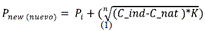
where Pnew is the point where the vector goes once the induced behavior occurs; Pt Is the initial point where the entity is, when it has its natural behavior; Cind is the variable or function which generates the induced behavior; Cnat is the variable or function that represents the entity natural behavior, and K is a constant obtained from the time in which the two behaviors are evaluated (sec); n is defined by the unity type (length, area or volume) that present the following behaviors: n is defined by the unity type (length, area or volume) that present the behaviors: If is in meters, then is n=1, if it is in m2, then n=2, and if is in m3, then n=3.
1) Shapes construction: The vector model has three primitives, which are modeled by the AVNG following a point continuum algorithm in each one of them, for which it is applied the equation (1) en each geographic entity point, to modify its structure in a new shape, that allows to visualize the two behaviors. An example of this is shown in Fig 1, where the natural behavior is visualized in blue, and the possible induced behaviors, in red, within the same shape geometric structure. In Fig 1a, it is visualized the primitive point; in 1b, the primitive line and in 1c, the primitive polygon.
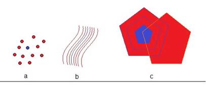
As may be observed, the origin vector is not modified, given that represents the natural behavior in color blue, and the induced behavior, in red color, it is generated in a new shapefile, allowing to realize comparisons of longitudes, areas and volumes for a further analysis in the decision taken.
D. A geo-inspired (AVNC) natural vector agent's proposal
The AVNG is based on the environmental aspects integration, modeled in two behaviors and in the vector agents' theory 8 based on the Euclidian geometry.
As it was mention, an AVNG represent a geographic or environmental entity, in which can be modeled two behaviors: The natural and the induced ones. The first, correspond to the entity natural state, which can be modified by the physic variables, without showing significant changes. In the present study, these variables are modeled by an aleatory variable. The second behavior is the one which represents the entity, when it overrides the natural function, which occurs when it is affected by one or more generated physical variables. In this moment the natural behavior is transformed in a induced behavior, or by the human intervention.
After these types of behaviors it was established the geographic function, that helps to integrate the Geographic information systems' visual component, starting from the vector model that represents the entities through the primitives (points, lines or polygons.) Each geographic entity has an initial vector which represents it.
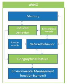
The natural behavior is associated to the initial vector, and from it are carried out the adjustments toward the induced behavior, in order to show its spatial variation. The last component is the environment management function, that supplies the control variable for the behavior or the agent induced function. In the Fig. 2 can be observed the proposed structure to the AVNG.
III. AVNG' GENERIC MODEL, IMPLEMENTED WITH JADE AND GEOTOOLS
To implant the functions and behaviors within a computation structure, was utilized the JADE library 17 for the agents and were defined the natural and induced behaviors. For the vector model geometry it was utilized the Geotools library 18 by including in the space reference system, the agent and the element, which support the geometry handling. These aspects were adjusted to their behavior throw the geographic function (See Fig. 3 Model in UML).
A. JADE
To develop the agents systems or multiagents, there are several platforms. JADE is one among the most known and used, due to its functionalities that allow to develop, among others, the agents application' development, that comply with FIPA' specifics for multi-agent systems 19,4.
The JADE agents platform, allows a distributed agents system, which functions using the Jave language, According to the multi-agents systems focus, an application on the JADE platform base, is composed by a cooperants agents group, that are able to communicate between them, through the messages interchange 4.
Each agent is immersed in an environment on which can act and whose happenings may be noticed. The environment may evolve dynamically, and the agents appear and disappear in the system, according the necessities and the applications' requirements. JADE supplies the necessary basic services for the environment application distribution, allowing each agent to discover others in a dynamical way and communicate with them.
B. Geotools
Geotools is a free code library for the geographic information systems that allows to develop solutions adapted to the standards that run under the JAVA programing language. It supplies the Open Geospatial Consortium' Specifications implementation 20.
The Geotools development allows to integrate the programing basic aspects to the SIG development, which had been restricted to some software developers' houses. This library fundamental aspect lies in that allows to manipulate the geographic entities implemented in the SIGs, enabling to modify and to edit the elements that already are the information system' passive part 21.
In the Multi-AVNG model, Geotools provides the fundamental code, to evaluate the initial vectors, which represent the entity and to model through JADE the studied entity' natural and induced behavior. This library used allows to visualize in a graphic way, the studied entity' induced behavior.
IV. IMPLEMENTATION PROPOSAL TO TURN THE MULTI-AVNG IN AN ENVIRONMENTAL PROBLEM (FLOODING)
Following are enunciated the elements that should be attended in a environmental problem analysis, when modeling the Multi-AVNG. It is necessary to identify these elements in order to structure correctly the Agents functioning. The facing problem is the visualization of flooded areas, after a strong precipitation.
A. Variables and functions that should be taking account
Natural behavior. From the mathematic and computational point of view, the natural shape, can be defined as the function that represents the natural entity behavior, and for the present study we will call it N (g), whose value is represented according to the study objective, for instance, a river flow.
Induced behavior. For practical effects, this agent function is defined as the behavior, that it assumes once has been influenced by the variable or the surroundings function. This function is called I(g): Example, a river flooding flow,
Function or surrounding variable. This function or surrounding variable is the cause to alter the natural behavior and to establish the induced behavior in the studied environment entity. There may be one or several variables, that intervene in the behavior change of the environmental entity. For example, based on the initial environment problem, we are able to talk about pluviosity.
Memory. Is the variable that stores the induced behavior in a time (t) to be transmitted to the same AVNG or to other within its context.
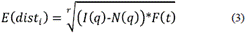
Geographic Function: The geographic function is the one that allows to vectorize the induced behavior, from the difference between its two behaviors, in a defined time interval (see equations 2, 3, 4 and 5).

With (M) memory = 0 the equation is the followed presented one:
With (M) memory > 0 the equation assumes the form:
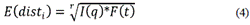
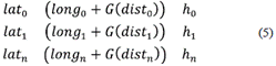
F(t) = The function or the time variable; N(g) = The natural behavior; I (q)= The induced behavior; latn, longn = The latitude and longitude values in the stretch n; The altitude value in the point n; The C value is a constant obtained from the reference shaefile measure unit and is given in meters. It works with the vector model and it is defined as the primitive and the space reference system to analyze each vector agent. r Is the entire value that assumes the root, which will depend from the unities of induced behavior (longitude, area or volume), For example, for m, r=1; for m2, r=2, and for m3, r=3.
Environment management function. The environment management function is the one which controls the behavior of the induced entity. This function tries to have tolerance degrees, between the natural behavior and the induced one, with the purpose to call alert when it is above the established limits.
B. Multi-AVNG System, to determine a flooded urban area
To use the Multi AVNG system, is presented a case study, in order to approach the flooded areas problem in an urban center. With that purpose, it is carried out the zone studied description, plus the functions and behaviors determination to be modeled, in order to use it in the proposed system.
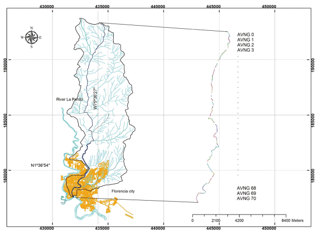
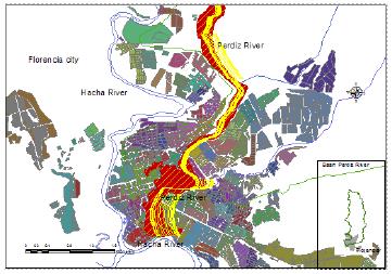
1) A case study: The tributary stream "la Perdiz", located in the Amazonia region, in the Colombian southest, between the south latitude 00 ° 42' 17" and 02° 04' 17" north latitude and 74° 18' 39" and 79° 19' 35" west longitudes, which represent the 7.79 % of the Colombian territory, in which is located in the Florencia municipality, the Caquetá department Capital, and represent a clear damage example, that may cause a small affluent within the urban centers. The flood conditions exposed have been little studied in this world region, given the amazon piedmont conditions, where the rough mountain views converge with the smooth plains. This land deep variety is the ideal scenery to prove the AVNG model, for the floodable areas definition.
2) Data origen to apply the Multi-AVNG as a study case: This geographic work development, was based on several digital information sources, among them: i) The Caqueta Department, Territorial Control Plan (POT), from which there were overplaced the risk regions in the Florencia municipality, allowing us to obtain the risks hydrologic map, where can be observed the zones that show landslides, flooding and geological faults. ii) Satelital image, LANDSAT 7, window -stream "the Perdiz' basin"-, the images are from 1998 and 2003, were obtained from the Amazonia University, Basic Sciences School, and the Geographic Institute Agustin Codazzi -IGAG- which allowed to have the study area reconnaissance and to digitize the vector base. iii) Aerial photography's: 9 Flight Photos from the C-2173 IGAC. -4 photos (241 to 244) obtained from the Basic Sciences School, and 5 photos (262 to 266) obtained from the IGAC- that allowed to digitized vectors from the zones which were shadowed in the satellite image. And iv) Plates: 3 official plates from the IGAC (389-VI-C and 413-II-A and C) at scale 1:25000. In this way were obtained the level curves, the houses positions, the schools and the roads infrastructure. In this way were built the irregular triangles networks (TIN) and the vectors based capes, that represent the geographic entity (La Perdiz streem).
The hydrographic data from 1969 to 2014, were obtained in the region, from the Colombian Hydrology, Meteorology and Environmental Studies (IDEAM), located in the coordinates shown in Table 1.
Table 1 Samples stations' location
| Station | Type | Coordinates | Hight | Period | Parameter |
| Airport | SS | 0136N - 7532W | 244 | 1969 -2014 | Rainfalls Temperature |
| Plants Florencia | PM | 0138N - 7537W | 270 | 1958-1973 | Rainfalls |
| Florencia CA | AM | 0137N - 7536W | 280 | 1970-1984 | Rainfalls Average Temperature |
From this data was consolidated the worst floods study, that has suffered the municipality, and was established the water flow that was generated, to finally find the one which allowed to proof the model in a known context, and in this way, to be able to validate the obtained data, with the registered historical data, and the flooded areas that were demarked by the rainfalls.
In May 24 of 2003, were inundated 10 town quarters, reaching an approximated number of 1500 persons affected by the floods. But the worst effect was caused to the roads infrastructure and to the water supply networks, whose services were suspended during more that 10 days in some of the city's quarters. Two months latter, on the July 14th of the same year, occurred a new hydroclimatic event, from which were reported 1.030 families affected, for a total of 5.200 people harmed.
3) DataSetproof Definition: The DataSet test is built with the registered rainfalls in the meteorological station, and from it, is made a 12 hours consolidation, to determine the basing behavior, with some pre-established values, and one hour intervals. Given that historically the sudden flooding, caused by rainfalls are developed between three to six hours, it is kept a margin for the results consolidation.
Besides, there were integrated the basing physical parameters, such as the area and the stream speed, in the stipulated stretches, in order to define the natural function parameters The induced function is called when the rainfall is higher than 0, in an hour lapse. The DATASET basic structure is shown in Table 2.
Table 2 Dataset structure realized in Microsoft Excel
| Height | Area | Speed | Basing Width | Left Slope | Right Slope | Pluviosity 1 (P1) | P2 | P3 | P11 | P12 | |
| m | m2 | m/s | M | % | % | mm o L/m2 | mm | Mm | mm | mm | |
The file can be built as an Excel table or a flat file, for which it should be, modified some libraries of the fountain codices. For the simulation, there were assigned fixed values, taken from one of the most severe flooding of the epoch history, which occurred on April the 28th of 2000, when it rained during three hours and approximately fell 50, 65 and 150 mm of rain 22. But the file can be linked in the nextworks by sensors located along the basing, in order to translate the data into real time.
4) Geographic entity vectorization (Stream La Perdiz): Starting from the geographic information obtained from the date sources already signaled, it is defined a set of vectors, that represent the entity to be processed. In the present research it was defined the area and the basing shape, factors that are important to calculate the induced behaviour. In this case study, the stream la Perdiz, is the geographic entity, and was divided in 71 sectors, given that has 71 variations in its gradient, along its stream from his origen to where it flows into the Hacha river. That is important, with the purpose to count with minor changes in the form and the volumne of the water that travels trough its basing.
Once it is vectorized the entity becomes the entrance to the AVNG sytem. It sholuld be remembered, that the vectorial model flexibility in the GIS, allows to represent every entity through out his primitives, therefore, it is necessary to realize a previous analysis, in order to determine, which one of them, is the one which represents in the right way, and on the adecuated scale, the geographic entity of the realized work.
5) The Multi-AVNG system definition and processing: Once are defined the entries, the dataset and the geographic entity representative vector for the AVNG, it proceeds to realize its execution, with the purpose to obtain the vectors demarcated area, that be affected by the water overflow.
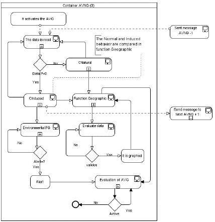
Once the data are introduced in the AVNG (DataSet), it proceeds to analyze each one of the entity sectors and to verify whether the entity is in its natural behavior or changes into its induced behavior, for which are verified the pluviosity values provided by the Dateset. Once carried out the comparison, it proceeds to store into the variable memory, the modified value in the sector, which is sent, through a message to the following AVNG, that is monitoring the following sector (See Figure 4).
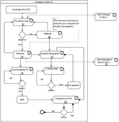
The value obtained from the message sent, is turned flow, given the situation. In this way, all the AVNG are into an additional entry for the AVNG, that receives it, communicated in a fall way all the AVNG, since the and is accumulated in the Natural or Induced function La Perdiz streem's birth, until its flow.
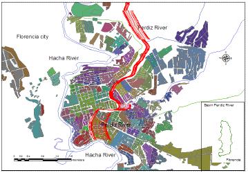
With the values obtained in each sector, before being sent to the following AVNG that receives it, is initiated the Geographic function, that takes the original vector points values (Figure 5) and modifies them, adding the generated values for the induced function to create vectors, that are displaced from the original sector. The obtained result is an image with vectors at certain distance form the original vector (Figure 9).
The obtained area, once the AVNG execution is visualized in the Figure 8, where it is demarked from the vectors that are displaced from the original vector toward the left or the right according the induced function, that is affected by the slope, the pluviosity values and the flow generated by the rainfalls.
V. RESULTS
As the Multi-AVNG execution' result, in order to face the flooded areas problem, in an urban center, was obtained a surrounding area to the original vector, which was compared with the historically demarked area, by the event occurred in the April 28th of, 2000.
A. Comparing the areas between the Multi-AVNG and the flooded area
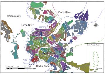
Florence city is located in the Figures 6 and 7, at higher scale is divided by living quarters, streets and avenues. The urban area is located to the South of the municipality, and is irradiated by multiple water sources, among them the La Perdiz streem.
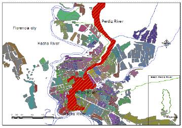
From the satellite image, that shows the flooded area, was obtained a shape file, which limits this area (see Figure 7) and was compared with the vectors generated by the MultiAVNG system that obtained a shape filed, with the generated sections (see Figure 8.), In the two results comparison is shown in the Figure 9, where the differences within the defined area and the one obtained by the AVNG, are evidenced.
Once were obtained the generated areas by the Multi-ABNG system, it was proceeded to take the remotest vector from the original vector, both by the left side as by the right one, in order to obtain an area on the TIN or the generated raster. Departing form this information it was utilized the method employed by 7 calculate the flooded area and the generated area by the system approximation percentage, for which it was utilized de equation (6).
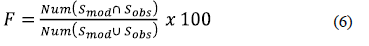
Smod y Sobs are the dominion sets or subregions (pixels, elements or cells) shown as flooded by the model and the historical date, reflected in maps or satellite images, and Numb (*) notes the group's member numbers. Therefore it varies between 0, for the model without covert between the flooded areas, and 100, for a model, in which the prediction data fully coincide with the observed 7 obtaining the following results (Table 3).
Table 3 Flooded area percentage results and the generated by the multi-avng model
| Data | Generated Area vs. Flooded Area (%) | Presented Error | With adjustments |
|---|---|---|---|
| The April 28th of 2000 (Flooded area) | 100.00 | 0.00 | No |
| Multi-AVNG Model | 70.29 | 29.71 | No |
| Without Model event Multi-AVNG | 95.78 | 4.22 | No |
As can be observed, when using the comparison method [7], it was obtained a 70.29% of flooded area, from the Multi-AVNG model, achieving to consolidate a clear area, where the agents induced behavior had influence. Besides the model was evaluated, when there were not catastrophic events' pluviosity data. The system reflected only the entity natural behavior, in this case with the 95.78% of the area, related to the environment entity normal course. It is due to clarify that it is necessary more trials with different events, but for this study object demonstration, the agents change their behavior and reflect in the vectorial model structure, an approximation to the environmental entity. Nevertheless, it can advance in the following works, by improving the new behaviors.
VI. DISCUSSION AND CONCLUSIONS
There are works related with the geographic vectors agents 8 in which, departing from the automatic cell concept 2 it is included the Euclidian geometry, in order to generate an autonomous entity, that uses the vector model.
The related works with the vectors agents present a development towards the geographic informatics systems, nevertheless we find problems in the generated data control, due that the growing vectors tends to become autonomous, occasioning none environment behavior's representative disproportion
In this article was tackled the concept of the natural geoinspired vector agent, in order to visualize the amazon piedmont urban areas affected by flooding. The AVNG formulates the multiagents system creation, starting from the entity natural behavior and the induced behavior by environment variables or functions, and allows visualizing the urban flooded zones.
The Multi-AVNG model computing implementation in the JADE platform, with the Geotools library, allows to use the point, lines or polygons primitives, in order to represent in a dynamic way the environmental entities and their problems, starting from their natural and induced behavior modeling, plus to monitor them through the geographic function and the environmental management.
The Multi-AVNG system is very different from the geographic vectors agents, in the following aspects: a) Does not modifies the initial vector. b) The results can be seen, in a new set of vectors; c) With the results achieved, it can obtain his vector agent validations. d.) It may include controls in the result generation process. e) The induced behaviors can be monitored, according the required parameters to the system, achieving in this way, an approximation to the environmental entity required study behaviors.
There may be presented future studies as case studies in the environmental problems 23,24 related with the land use, the climate change, the flora, the fauna and even the water resources' same category, but focused in other situations where the Multi-AVNG system is used, to monitor or evidence the environmental problems.

