SciELO - Scientific Electronic Library Online

 
vol.29 issue54Comparison Between Machine Learning Models for Yield Forecast in Cocoa Crops in Santander, ColombiaPolymeric Ablative Composite Materials and their Application in the Manufacture of Aerospace Propulsion Components author indexsubject indexarticles search
Home Pagealphabetic serial listing  

Services on Demand

Journal

Article

Indicators

Related links

  • On index processCited by Google
  • Have no similar articlesSimilars in SciELO
  • On index processSimilars in Google

Share


Revista Facultad de Ingeniería

Print version ISSN 0121-1129On-line version ISSN 2357-5328

Rev. Fac. ing. vol.29 no.54 Tunja Jan./Mar. 2020  Epub July 30, 2020

https://doi.org/10.19053/01211129.v29.n54.2020.10891 

Papers

Exploratory Study on Wetlands Area Decrease in Bogota due to Construction Activity: 1950-2016

Estudio exploratorio sobre la disminución del área de humedales en Bogotá debido a la actividad de construcción: 1950-2016

Estudo exploratório sobre a diminuição da área de pantanais em Bogotá devido à atividade de construção: 1950-2016

César-Augusto García-Ubaque1 
http://orcid.org/0000-0002-1825-0097

Edgar-Orlando Ladino-Moreno2 
http://orcid.org/0000-0002-7770-452X

Eduardo Zamudio-Huertas3 
http://orcid.org/0000-0002-9698-5419

1Ph. D. Universidad Distrital Francisco José de Caldas (Bogotá-Distrito Capital, Colombia)

2M. Sc. Universidad Distrital Francisco José de Caldas (Bogotá-Distrito Capital, Colombia)

3M. Sc. Universidad Distrital Francisco José de Caldas (Bogotá-Distrito Capital, Colombia).


Abstract

The aim of the study was to quantify in an explorative way the damage of the wetland area because of drying and construction activities, from 1950 to 2016 in Bogota city. To such end, an estimate of the wetland area of Bogotá was made for the years 1950, 1989, and 2016 by reviewing the geographic information of the Agustín Codazzi Geographical Institute (IGAC) and the Aqueduct and Sewer Bogota Company (EAAB). The information was processed using AutoCAD software in order to perform the analysis of the area variation for each water body. The data shows that the city's water mirror area has decreased by an average of 84.52% between the years of 1950, 1989, and 2016, except for El Tunjo wetland (which grew 79.45%). This situation shows that the protection that has been implemented happened too late, since a considerable portion of these ecosystems rich in fauna and flora is lost. This has generated phenomena such as: flooding of settlements in these areas, disappearance or displacement of endemic species of flora and fauna, and displacement of wetlands.

Keywords environmental deterioration; land use; soil pollution, swampy land; urban planning; urbanization

Resumen

El objetivo de este estudio es cuantificar de manera exploratoria el daño en el área de humedales por desecamiento y construcción de 1950 a 2016 en la ciudad de Bogotá. Para dicho fin se realizó una estimación de dicho ecosistema de 1950, 1989 y 2016, a partir de la revisión de la información geográfica del Instituto Geográfico Agustín Codazzi (IGAC) y de la Empresa de Acueducto y Alcantarillado de Bogotá (EAAB). Se digitó la información utilizando el software AutoCAD, para luego realizar el análisis de la variación de área para cada uno de estos cuerpos de agua. Los datos obtenidos muestran que el área del espejo de agua de los humedales de la ciudad se ha reducido en un 84.52%, en promedio, entre 1950, 1989 y 2016, con excepción del humedal “El Tunjo”, el cual creció 79.45%. Esta situación evidencia que la protección que se ha implementado fue tardía, ya que se ha perdido una porción considerable de estos ecosistemas ricos en fauna y flora, lo cual ha generado fenómenos como inundaciones de los asentamientos en estas áreas, desaparición o desplazamiento de especies endémicas de flora y fauna y desplazamiento de las zonas húmedas.

Palabras clave contaminación del suelo; deterioro ambiental; planificación urbana; tierra pantanosa; urbanización; uso de la tierra

Resumo

O objetivo deste estudo é quantificar de maneira exploratória o dano na área de pantanais por dessecamento e construção de 1950 a 2016 na cidade de Bogotá. Para tal fim realizou-se uma estimação de dito ecossistema de 1950, 1989 e 2016, a partir da revisão da informação geográfica do Instituto Geográfico Agustín Codazzi (IGAC) e da Empresa de Aqueduto e Esgoto de Bogotá (EAAB). Realizou-se a análise da variação de área para cada um dos corpos de água; os dados obtidos mostram que a área do espelho de água dos pantanais da cidade tem sido reduzida em um 84.52%, em média, entre 1950, 1989 e 2016, com exceção do pantanal “El Tunjo”, que cresceu 79.45%. Esta situação evidencia que a proteção que tem sido implementada foi tardia, já que tem sido perdida uma porção considerável destes ecossistemas ricos em fauna e flora, o que tem gerado fenômenos como inundações dos assentamentos nestas áreas, desaparição ou deslocamento de espécies endêmicas de flora e fauna e deslocamento das zonas húmidas.

Palavras-chave contaminação do solo; deterioro ambiental; planejamento urbano; terra pantanosa; urbanização; uso da terra

I. INTRODUCTION

There are several ways of describing the wetlands. However, the most extensive is the one presented in [1], where the author defined them as “Extensions of marshes, swamps, bogs, or natural or artificial waters, permanent or temporary, stagnant or running, sweet, brackish or salty, including the extensions of sea water with a depth at low tide not bigger than six meters”. Wetlands are formed in places where the phreatic layer is found in the ground surface or near it, or where the land is covered by shallow waters. Wetlands are part of the Earth’s ecosystems that stand out for its biological wealth, its high productivity and biodiversity resembling biological rainforests [2].

According to the Ramsar Convention, wetlands are classified into five great systems according to their biological and physical properties: a) marine: shore wetlands including rocky shores and coral reefs; b) estuarian: deltas, tide marshes, and mangrove swamps; c) lacustrine: lakes; d) riparian: wetlands associated to rivers and streams, and e) marsh: morasses, marshes, and swamps [3].

Following this classification, wetlands found in the city of Bogotá are part of the lacustrine and riparian systems, given their elevation above sea level. Generally speaking, these zones fulfill a hydraulic regulation function by cushioning the effect of the waves, stocking flood waters, holding sediments, and reducing pollution levels; and that is why they are denominated “nature’s kidneys.” [2]

Due to the ecosystem importance of these water bodies, its preservation must be a priority in the territorial ordering politics, but currently the acting of the government parties in charge of their protection has been void. As a consequence, there is a reduction, deterioration, and pollution process [4]. In addition to this, the migration of rural population to big cities, metropolitan areas, and intermediate cities from 1940 to 1990 was approximately 21.3 million people [5] and generated the increasing of the urban use of land and non-controlled settlements around wetlands. This event generated irreparable damages that lead to the complete drying of the water mirror of these ecosystems in order to get urban soil. The aim of this study is to quantify in an explorative way the damaging process of these ecosystems due to drying and construction activities from 1950 to 2016 in Bogota.

II. MATERIALS AND METHODS

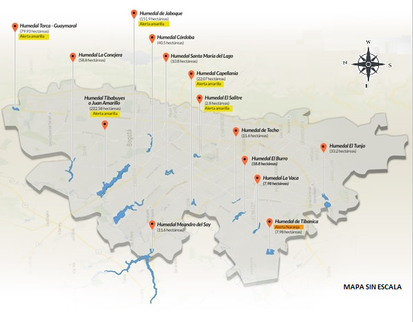
An estimation of the wetland area of Bogota in 1950, 1989, and 2016 was made through the review of geographic information from the Agustín Codazzi Geographical Institute (IGAC) and the Aqueduct and Sewer Bogotá Company (EAAB). The information was digitized with the help of AutoCAD software in order to perform the analysis of the area variation of these water bodies in the city. Figure 1 shows the location of the wetlands in Bogota– the ones included in the study.

Fig. 1. Known wetlands in Bogota [6]. 

III. RESULTS

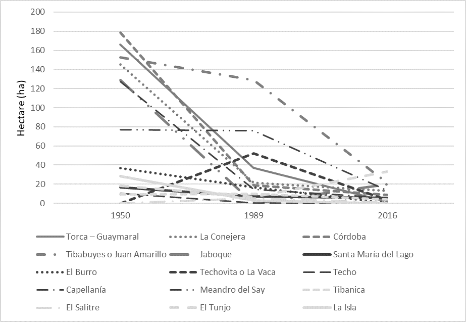
After the information related to the selected wetlands was collected, the most relevant data was put in Table 1. The results allowed us to estimate the alterations on the water mirror area of each ecosystem, as an aftermath of the construction processes. The table also includes the consulted sources in which the information of the city’s wetlands is compiled.

Table 1 Estimation of the water mirror area loss in hectares (ha) from wetlands known by the Environment District Secretary between 1950, 1989 y 2016. 

Wetland Basin Location Water Mirror Area Lost Area (%) Source
1950 1989 2016 1950-1989 1950-2016
Torca-Guaymaral Torca Usaquén Suba 166.03 36.89 1.50 77.78 99.10 [7]
La Conejera Conejera Suba 145.02 21.59 13.16 85.11 90.93 [8]
Córdoba Salitre Suba 178.45 18.78 8.82 89.47 95.06 [9]
Tibabuyes o Juan Amarillo Salitre Suba Engativá 152.56 128.83 21.39 15.59 85.98 [10]
Jaboque Jaboque Engativá 128.62 113.17 20.02 12.01 84.43 [11]
Santa María del Lago Salitre Engativá 16.47 7.29 5.64 55.74 65.75 [12]
El Burro Fucha Kennedy 36.66 16.91 0.20 53.88 99.45 [13]
Techovita o La Vaca Fucha Kennedy - 51.94 3.37 - - [14]
Techo Fucha Kennedy 10.32 0.49 - 95.28 - [15] [16]
Capellanía Fucha Fontibón 127.23 14.75 5.84 88.40 95.41 [17][18]
Meandro del Say Fucha Fontibón 77.19 76.20 13.60 1.29 82.38 [19]
Tibanica Tunjuelo Bosa 9.18 10.01 3.79 +9.04 58.71 [20]
El Salitre Salitre Barrios Unidos - 5.59 1.30 - - [21] [22]
El Tunjo Tunjuelo Tunjuelito Ciudad Bolívar 18.50 6.78 33.20 63.34 +79.45 [23] [24]
La Isla Tunjuelo Bosa 28.28 3.04 - 89.25 - [23][25]

Fig. 2. Loss of the water mirror area of the wetlands in Bogota D.C. 

IV. ANALYSIS

According to the available data collected and analyzed in this study, the behavior of the wetland areas in the city of Bogota on 1950, 1989 and 2016 shows an average decrease of 84,52% in width, except for the wetland located in “El Tunjo”, which grew 79,45%. This shows that the protection measures were implemented too late, and a considerable portion of these ecosystems rich in flora and fauna and necessary for the cushioning and storing of flood waters has been lost [2].

Wetlands are of fundamental ecological importance [26] because they perform a vital part in several phenomena and natural processes [27]. Therefore, different problems such as floods in non-planned settlements, migration or disappearing of endemic species, morphological changes, and displacement of wet zones, arise when wetlands are drained and dried.

The need to have institutional buildings and infrastructure has been the common denominator of urban settlement since the first half of the 20th century; thus, the construction of housing through informal land occupation has happened gradually. This process has happened without the correct evaluation of the environmental impact on the land and has damaged the ecosystems to the point of desiccating. Furthermore, one of the main factors that contributes to the pollution of wetlands is the disposal of contaminated waters that affects their delicate chemical balance [28].

When analyzing the loss of area in the Bogota wetlands, it is evident that construction is one of the causes for the disappearance or decrease of these bodies of water. Furthermore, despite the lack of conservation of the wetlands, they have not been completely extinguished.

These hydraulic regulatory ecosystems fulfill the important function of balancing and buffering floods [2] [29]. Therefore, the reduction of its area represents both an ecological and a security threat in the city, and to prevent it, it is necessary to implement public policies that advocate the rescue and conservation of wetlands. It is important to keep in mind that social and environmental interaction have a specific effect on human actions [30], and these ought to be a source of feedback because protecting urban ecosystems is as fundamental as conserving wetlands.

V. CONCLUSIONS

The decrease of the wetlands in the city of Bogota is directly related to the human settlements occurring during the second half of the 20th century because they located around water bodies. Also, the care of wetlands was inexistent to the point of almost desiccating them due to the need to supply the population with infrastructure and basic sanitation.

The protection and preservation of the Bogota wetlands during the second half of the last century has not been as effective. An average of almost 84% of these water bodies has been completely dried, so the city would not have these ecosystems 20 years from now, had the city government not decreed the care of these water bodies [31].

The hydraulic capacity of wetlands is one of their fundamental characteristics and shows the conformation of new wetland areas after uncontrolled construction desiccated those existing. Therefore, the planimetric translation is a visible evidence of the need for these ecosystems to buffering the river floods.

REFERENCES

[1] RAMSAR, Manual de la Convención Ramsar: Guía a la Convención sobre Humedales, Irán, Gland: Secretaría de la Convención de Ramsar, 2006. [ Links ]

[2] J. A. Kusler, W. J. Mitsch, and J. S. Larson, "Humedales," Investigación y Ciencia, vol. 210, pp. 6-13, Mar. 1994. [ Links ]

[3] M. Muñoz, H. Núñez, and J. Yáñez, Libro Rojo de sitios prioritarios para la conservación de la diversidad biológica de Chile, Santiago de Chile: Ministerio de Agricultura-Corporación Nacional Forestal, 1996. [ Links ]

[4] Alcaldía Mayor de Bogotá, Bogotá, Ciudad de Estadísticas. Boletín No. 31, Colomia, Bogotá D.C.: Secretaría Distrital de Planeación, 2011. [ Links ]

[5] J. O. Rueda Plata, "El campo y la ciudad: Colombia, de país rural a país urbano," Revista Credencial Historia, vol. 119, pp. 1-4 1999. [ Links ]

[6] D. P. Cruz-Solano, J. E. Motta-Morales, and C. A. García-Ubaque, Estimación de la pérdida de área en los humedales de Bogotá en las últimas cinco décadas debido a la construcción y sus respectivos efectos,Trabajo de Grado, Universidad Distrital Francisco José de Caldas, Bogotá D.C., Colombia, 2017. [ Links ]

[7] Corporación Autónoma Regional de Cundinamarca, Resolución Conjunta No. 02,Colombia, Bogotá D.C.: Corporación Autónoma Regional de Cundinamarca y Secretaría Distrital de Ambiente, 2015. [ Links ]

[8] Empresa de Acueducto y Alcantarillado de Bogotá, Plan de Manejo Ambiental Humedal La Conejera, Colombia, Bogotá D.C.: Empresa de Acueducto y Alcantarillado de Bogotá, 2006. [ Links ]

[9] Secretaría Distrital de Ambiente de Bogotá, Plan de Manejo del Humedal Córdoba, Colombia, Bogotá D.C.: Secretaría Distrital de Ambiente de Bogotá, 2008. [ Links ]

[10] Empresa de Acueducto y Alcantarillado de Bogota, Plan de Manejo Ambiental Humedal Juan Amarillo, Colombia, Bogotá D.C.: Empresa de Acueducto y Alcantarillado de Bogota, 2010. [ Links ]

[11] Empresa de Acueducto y Alcantarillado de Bogota, Plan de Manejo Ambiental Humedal Jaboque," Colombia, Bogotá D.C.: Empresa de Acueducto y Alcantarillado de Bogota, 2008. [ Links ]

[12] Empresa de Acueducto y Alcantarillado de Bogota, Plan de Manejo Ambiental del Parque Ecológico Distrital del Humedal Santa María del Lago, Colombia, Bogotá D.C.: Empresa de Acueducto y Alcantarillado de Bogota, 2010. [ Links ]

[13] Empresa de Acueducto y Alcantarillado de Bogota, Plan de manejo ambiental del Humedal El Burro, Colombia, Bogotá D.C.: Empresa de Acueducto y Alcantarillado de Bogota, 2008. [ Links ]

[14] Empresa de Acueducto y Alcantarillado de Bogota, Plan de Manejo Ambiental Humedal La Vaca, Colombia, Bogotá D.C.: Empresa de Acueducto y Alcantarillado de Bogota, 2009. [ Links ]

[15] Fundación Humedales Bogotá, Humedal de Techo, Colombia, Bogotá D.C.: Fundación Humedales Bogotá, 2005. http://humedalesbogota.com/humedal-de-techo/Links ]

[16] Empresa de Acueducto y Alcantarillado de Bogota, Plan de Manejo Humedal de Techo, Colombia, Bogotá D.C.: Empresa de Acueducto y Alcantarillado de Bogota, 2009. [ Links ]

[17] Empresa de Acueducto y Alcantarillado de Bogota, Plan de Manejo Ambiental Humedal Capellanía, Colombia, Bogotá D.C.: Empresa de Acueducto y Alcantarillado de Bogota, 2008. [ Links ]

[18] Empresa de Acueducto y Alcantarillado de Bogota, Plan de Manejo Ambiental Humedal Capellanía, Colombia, Bogotá D.C.: Empresa de Acueducto y Alcantarillado de Bogota, 2008. [ Links ]

[19] Secretaría Distrital de Ambiente, Plan de Manejo Ambiental del Parque Ecológico Distrital Humedal Meandro del Say, Colombia, Bogotá D.C.: Secretaría Distrital de Ambiente, 2009. [ Links ]

[20] Departamento Técnico Administrativo del Medio Ambiente, Formulación del Plan de Manejo Ambiental del Parque Ecológico Distrital Humedal Tibanica, Colombia, Bogotá D.C.: Departamento Técnico Administrativo del Medio Ambiente, 2006. [ Links ]

[21] E. Abril, "Humedal El Salitre: Un ejemplo exitoso de la defensa de los humedales de Bogotá," Revista Digital Fulica, vol. 1, pp. 17-21, 2014. [ Links ]

[22] Concejo de Bogotá, Acuerdo 487-Declara como área inundadle "El Salitre", Colombia, Bogotá D.C.: Concejo de Bogotá, 2011. [ Links ]

[23] Concejo de Bogotá Acuerdo 577-Declara como Parques Ecológicos Distritales de Humedal -PEDH-, Los humedales de Ribera el "Tunjo" y "la Isla", Colombia, Bogotá D.C.: Concejo de Bogotá, 2014. [ Links ]

[24] Secretaría Distrital de Ambiente, Resolución 3561 - Se aprueba el Plan de Manejo Ambiental del Parque Ecológico Distrital de Humedal El Tunjo, Colombia, Bogotá D.C.: Secretaría Distrital de Ambiente, 2019. [ Links ]

[25] Fundación Humedales Bogotá, Humedal La Isla, Colombia, Bogotá D.C.: Fundación Humedales Bogotá, 2014. http://humedalesbogota.com/2014/02/11/humedal-la-isla/Links ]

[26] W. J. Mitsch, and J. G. Gossenlink, Wetlands, United States, New York: Van Nostrand Reinhold, 1988. [ Links ]

[27] P. Dugan, Wetland Conservation: A review of current issues and requiered action, Gland: Unión Internacional para la Conservación de la Naturaleza, 1990. [ Links ]

[28] C. C. Parrado Delgado, Metodología para la ordenación del territorio para el prisma de sostenibilidad (Estudio de su aplicación en la ciudad de Bogotá D.C.), Doctoral Thesis, Universidad Politécnica de Cataluña, Barcelona, Spain, 2001. [ Links ]

[29] E. G. Forero, "Humedales: Patrimonio Natural de Bogotá," El Espectador, 2017. https://www.elespectador.com/opinion/humedales-patrimonio-natural-de-bogota-0 Links ]

[30] D. C. Palacio, and R. F. Hurtado, "Narrativas y redes de la gestión ambiental de los humedales de Bogotá," Nómadas, vol. 22, pp. 140-150, 2005. [ Links ]

[31] Secretaría Distrital de Ambiente, Decreto 624 - Política de Humedales del Distrito Capital, Colombia, Bogotá D.C.: Secretaría Distrital de Ambiente, 2007. [ Links ]

Received: March 08, 2020; Accepted: April 25, 2020

AUTHOR’S CONTRIBUTION: García-Ubaque made the conceptual structuring of the article and the inventory of the existing wetlands in Bogotá; Ladino-Moreno and Zamudio-Huertas made the documentary review and the quantification of area losses of each wetland. The three authors oversaw writing, reviewing, and adjusting the final document.

Conflict of interest: The authors state there is no conflict of interest.

Creative Commons License This work is under License Creative Commons Attribution 4.0 International.