


 Inglês (pdf)
 Artigo em XML
 Referências do artigo
 Enviar este artigo por email
 Citado por SciELO
  Citado por Google
  Similares em
SciELO
Similares em
SciELO  Similares em Google
 Permalink
I. INTRODUCTION
The evolution of geographic knowledge has come together with the technological advances in geolocation, mapping tools, development of portable devices, web 2.0 applications and the widespread diffusion of the internet supported by modern participatory practices such as crowdsourcing and crowdmapping. [1]. Especially in the last two practices, the term participatory in geography brings the processes that involve local communities in the preparatory phases of territorial planning and management through mapping developed by the proposing entities themselves. In this context, Goodchild [2] defines Volunteered Geographical Information (VGI) as information produced with the help of web geotechnologies, neogeography and collective intelligence with which citizens interact voluntarily.
VGI is closely related to the concept of Crowdsourcing coined in 2006 by Howe [3] and of which Estelles and González [4] propose a more compact definition, “a type of online participatory activity in which a person, institution, non-profit organization or company proposes to a group of individuals, through an open and flexible call, the free and voluntary accomplishment of a specific task”; this is intended to generate benefits for the community in general and for the individuals involved in the process, addressing the basic needs of the community.
Crowdmapping refers to the way of collecting and sharing geographic information through Crowdsourcing [1], in some cases, understood as a process and, in other cases, as a tool. Thus, Crowdmapping represents the collaborative mapping process that takes place through the use of platforms and sites that through API (Application Programming Interface) of the main cartographic datasets such as (Google Maps and OpenStreet Map) propose so called mash-ups for Crowdsourced mapping of topics often related to civic engagement and digital activism. At the same time, it can be used by administrations to support management of participatory processes that seek to monitor the transformations taking place in the city in order to know and control them.
The first Crowdmapping experience emerged in Kenya back in 2008 with the idea of creating an online map with the complaints and reports of the citizens about post-election violence. Back then, a non-profit company decided to develop a free and open-source software to collect this information through SMS, e-mails or web, in order to geolocate it and visualize it on a map through the Ushahidi [5] platform. Since then, this platform has been used to monitor, map and track cases of violence, natural disasters, spread of infections, creation of mutual aid networks, environmental monitoring and most recently COVID-19 cases.
Regarding the creation of collaborative maps in urban categories, Pinilla [6], relates projects in countries such as Colombia, Argentina, Ecuador, Nigeria and Spain for the monitoring and follow-up of urban problems related to basic sanitation, garbage control, environment, security and mobility.
Currently, there are constant complaints from builders and property owners to the urban planning offices due to delays in the issuance of construction licenses such as those for the recognition of Social Interest Housing (VIS), which in compliance with the law seek to safeguard the right to private property and guarantee the right to decent housing. During 2019 and 2020, Avendaño [7], collected petitions, complaints, claims and suggestions from users of three different urban planning offices in Bogotá, finding nonconformities for the noncompliance and failures of internal processes that generate excessive response time to resolve licensing procedures by these entities.
The lack of digital mechanisms in the urban planning actions carried out by the urban curator's offices in the stages of filing and document review, and the growing demand in the building industry represent a challenge for urban planning offices to develop ways of working collaboratively with the community and to manage knowledge through practices such as Crowdmapping, with the objective of creating a common vision and action to solve public problems with a transformative logic [8], in cities where urban growth has been significant during the last years and which has made people to build their homes informally without any type of approval in the compliance of minimum requirements, in some cases, due to lack of economic resources, lack of knowledge of the Law, lack of responsibility of the builders and delays in the procedures of the urban planning offices [9]
In view of the above, the purpose of this article is to make a descriptive analysis of Crowdmapping implementation through platforms that aim to create collaborative maps in order to define the viability of including it as an application proposal in VIS recognition processes, necessary to legalize informally built housing. It is proposed to characterize the VIS recognition process and develop a proposal within the administrative management performed by urban planning offices as a solution to collect, visualize and analyze geolocated information in a more efficient way, reducing the internal response time in obtaining VIS recognition licenses.
II. METHODOLOGY
A review and analysis of the variables that are part of the platforms for the implementation of crowdmapping and case studies developed to evaluate the relevance of its application in the recognition of social housing in urban planning offices was carried out.
For the review, it was defined that the publications to be considered should be of primary category such as articles published in scientific journals and of secondary category as theses, reviews and research reports. The search for these documents was carried out in databases as Redalyc, Science Direct, Google Scholar, Springer and Semantic Scholar, looking first for the term “Crowdmapping” and it was complemented in a more specific way with keywords in Spanish and English such as “crowdmap”, “volunteered geographic information (VGI)”, “collaborative mapping platforms”, “humanitarian mapping”, among others.
In order to have an overview of the adoption of Crowdmapping in the scientific community, a documentary search was conducted to establish the frequency with which the term "Crowdmapping" appears, including filters by year to visualize the growth of the information, setting as a base the year 2008, in which it was registered the first crowdmapping case, and filtering by increasing period. The results are displayed in Table 1. The information presented in the tables indicates an incremental pattern representing an interest of the scientific community in this novel practice.
Table 1 Search results for the term "Crowdmapping" in the databases and years indicated.
*The final number of publications for this year is not yet available, since it has not yet been completed.
In order to complement this search, a scientific mapping was carried out by applying the association technique using the VOSviewer bibliographic network visualization tool. From the Dimensions database, 162 publication articles associated with Crowdmapping between the years 2012 to 2022 were collected through metadata. In Figure 1, co-authorship between country is displayed. Each circle represents a country, and the size represents the number of articles published in the selected database. The distance between countries reflects the strength authorship and the colors indicate clusters of countries that are related to each other.
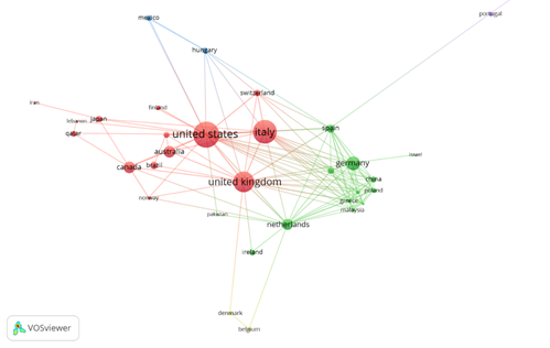
Fig. 1 Visualization of a co-authorship network between countries whose authors have published at least one paper related to Crowdmapping. (2012-2022).
Subsequently, documents with significant information were selected in order to make this review, focusing on projects describing experiences of collaborative mapping within urban intervention planning processes, analysis of volunteer participation in humanitarian crowdmapping, models of geographic data management in crowdmapping platforms and methodologic proposal for collaboration in crowdmapping. Documents with quantitative analysis and case studies related to Crowdsourcing were excluded. Finally, the current Colombian regulations applicable to social housing recognition projects were reviewed in order to characterize this process and determine the feasibility of implementing crowdmapping within it.
III. RESULTS
Crowdmapping projects have been developed on pioneering platforms that are still in use today. Next, there is a description of the process of three platforms that in terms of implementation have been the most used.
A. Ushahidi
It is an open software tool that collects, manages and visualizes data. According to the official website (https://www.ushahidi.com/) it has been implemented in more than 159 countries as a replicable solution for people and organizations that need to report or understand a phenomenon to request support and provide transparency to their problems, among its main uses.
It collects georeferenced information from multiple sources through customized surveys developed by the Crowdsourcer. Data or publications can be managed and classified with filters and workflows according to a role-based security model that grants permission to each defined user. The visualization of the data can be made through a map, a list, a graphic or a table by setting periods in which it is needed to analyze and compare specific variables.
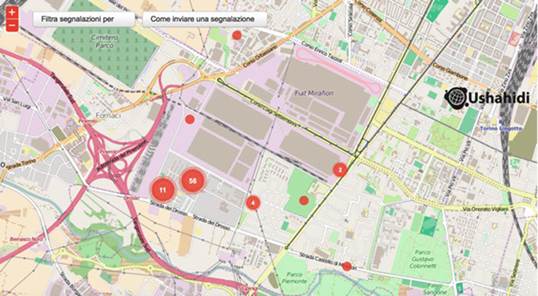
An example of Crowdmapping implementation making use of Ushahidi is MiraMap. [10]. This project, developed in Turin, provides a map that identifies physical, spatial or cultural barriers and obstacles that prevent to some vulnerable people from accessing and using the public space available to them. This experience focused on stablishing connections in the territory and institutional relations between the community and the public administration in order to propose active and participative solutions. Figure 2 shows the map developed with this Crowdmapping implementation.
B. OpenStreetMaps (OSM)
It is a collaborative open software platform whose initiative is to foster the growth, development and distribution of geospatial data. A team of volunteers manage the infrastructure and the web sites in which collaborative projects are found for specific purposes while users contribute data to the map, the wiki, by using mapping techniques from information collected by themselves of by other mappers.
According to the official website (https://wiki.openstreetmap.org/), data collection is based on two structures (elements and labels). The elements correspond to nodes (defined points), pathways (linear features and boundary areas) and relationships (complex forms of relationships). On the other hand, labels are used to describe the meaning of the elements. The management of the information is on each mapper; however, it is possible to count on community collaborators or a data working team provided by the OpenStreetMap Foundation (OSMF) whose support work addresses to solve data compatibility problems and to hide sensible material registered during Crowdmapping. Finally, data visualization is provided through layers on the map.
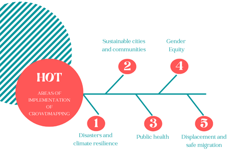
Humanitarian OpenStreetMap Team (HOT) is an international team which main function is to create and keep collaborative maps for humanitarian purposes as an answer to disasters and specific relief needs using the OSM platform as a technical basis [11]. In the case of Colombia, on the official website (https://www.hotosm.org/) registers a project to build the resilience of agricultural communities to disasters caused by earthquakes and large volumes of landslides during the rainy season. The purpose of this project is to create land use planning maps. Figure 3 shows the areas of Crowdmapping implementation by HOT.
C. Google My Maps
It is a platform that can be accessed through an API that serves as cartographic base for Crowdmapping applications such as Wikimapia,Tagzania,Panoramio, and others. Its function is to collect data and classify it by geotagging users. The project is like OSM with the difference that the maps are not free and are still owned by Google. The information is accepted by collaborators with a peer review mechanism and vetted by Google before being published on the base map [1].
Mezzacapo [1], in his published study "Crowdmapping e civic engagement nella società digitale," after analyzing collaborative mapping applications and tools, defined a categorization according to the source code of the platform (open - free software or closed - private software), possibility of reuse of the data produced by crowdmappers and the dataset of the base map (open such as OpenstreetMap or closed such as Google Maps, Bing Maps, Yahoo Maps). Table 2 presents the types of platforms according to the geographic data management model and the crowdmapping process of the analyzed platforms based on how they collect, manage and visualize data.
Table 2 Comparative table of crowdmapping platforms.
| Platform | Data collecting | Information management | Data Visualization | Source code | Data reuse | Cartographic dataset | Mash-Ups* | |
|---|---|---|---|---|---|---|---|---|
| Ushahidi |
|
|
|
Open | Closed | Open & closed |
|
|
| OpenStreetMaps (OMS) |
|
|
Map | Open | Open | Open |
|
|
| Google My Maps |
|
|
Map | Closed | Closed | Closed |
|
|
* Some Mash-Ups mentioned in the official sites of the platforms are listed.
IV. PROPOSAL FOR THE IMPLEMENTATION OF CROWDMAPPING IN THE VIS RECOGNITION PROCESS
Both the crowdsourcer and the crowdmapper follow specific workflows within the Crowdmapping process. The Crowdmapper oversees registering the implementation in the work platform, configuring data and general map settings, creating tasks, assigning roles, permissions and sharing the tasks for execution. Once the tasks are published to the community, the crowdmappers develop them by submitting the required information to the requester for analysis. At this point, a quality verification cycle is performed, and a status report is presented to verify compliance. If the task is OK, the information collected is accepted to be displayed on the map; otherwise, it is rejected and discarded, in which case the crowdmapper would have to perform it again until it meets the quality criteria of the information it is recording. Figure 4 shows the general workflow for Crowdmapping implementation.
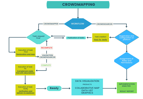
The tasks proposed in the workflow are based on the Find, Fix, Verify pattern implemented in the urban object mapping and proposed by Van Alphen [12], which divide tasks into a series of generation and revision stages to guarantee a high quality in the results obtained by the crowdmappers.
In the creation of roles and permissions, Martinez et al. [13], proposes a model in which the assignment of roles is made according to the level of expertise and participation of the collaborators in the tasks defined by priority and complexity.
While the publication of crowdsourcer-created tasks can be shared through websites, implementers should consider coordinating campaigns to build the capacity of volunteers. Dittus [11] suggests that social contribution environments such as mapathons offer support to inexperienced or inexperienced contributors. These are developed as a social event that allows groups to socialize and learn from practice.
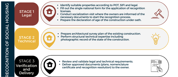
According to Section 2 Chapter 4 of Executive Order 1077 of 2015 and its amendment (Executive order 1033 of 2020), in Figure 5 it is describes in general terms the process to perform the VIS recognition procedure used by Curadurías Cero, already constituted in the country to comply with current regulations.
Considering that the objective of using crwodmapping in the process of recognition will be to collect information and geolocate it in a base map and not to create the map as such, the Ushahidi platform is selected for its implementation. The data collection and information management process of Ushahidi, in Table 3 defines tasks, surveys, roles/users and permissions required for the implementation of each stage of the VIS recognition process.
Table 3 Definition of tasks, surveys, roles, users and permissions for the implementation of crowdmapping in the recognition of Social Housing (VIS).
| Stages | Data collection (Surveys) | Task type | Role/User | Permissions |
|---|---|---|---|---|
| 1. Legal |
|
|
|
Editing and deleting their own publications. |
| 2. Technical |
|
Fix Expertise level Intermediate |
|
Manage users, Import and export data, edit and delete publications. |
| 3. Verification and delivery | 1.Number of approved recognition resolution |
|
|
Manage users, publications, settings, Import and export data, edit and delete publications |
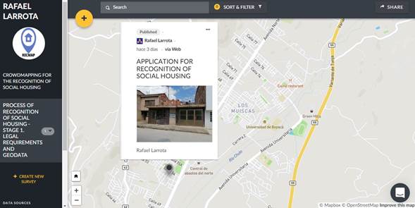
Once the base information required by the platform has been defined, the crowdmapping workflow described in Figure 4 is followed to obtain a collaborative map. Figure 6 shows the map as a product of the implementation, indicating a geolocated publication made by a Crowdmapper for a house located in the city of Tunja, after collecting the information required in the Stage 1 survey and validated by the Crowdsoucer.
V. DISCUSION AND CONCLUSIONS
Currently, Curadurias Cero, the entities in charge of performing the VIS surveys, require field visits by their technical team in order to collect specific information from the owners of the properties, indicating the necessary documents required for the process and geolocating the homes for internal registration. As observed in the implementation proposal, this can be developed through the creation of surveys and the assignment of tasks developed by the Crowdmappers which in this case, would be the homeowners themselves, allowing the optimization of times and resources in the management of these entities.
Even though one of the main limitations that the implementations may have is the digital gap in terms of access to digital media and technologies by users, it could be addressed from social events such as mapathons, socialization spaces in which officials and administrators of urban planning offices give the opportunity to those interested in being volunteer Crowdmappers to acquire specific skills useful for Crowdmapping.
The feasibility of integrating Crowdmapping into the administrative processes of the urban planning offices encourages the development of better planning, management and governance practices by promoting active participation of the community. The workflow proposed for implementation should be adapted as best as possible to the characteristics of the administrative process developed by each urban planning office to make it more efficient. Likewise, a strategic plan for the implementation, monitoring and evaluation of the Crowdmapping process should be developed.
The selection of platforms to implement Crowdmapping projects has implications on the creation of the collaborative map (Crowdsourced) and on the data management model (open or closed). On one hand, the map can be conceived as the product in which information on territorial processes is collected on a cartographic base (Ushahidi) or as the construction of the cartographic base itself from elements and labels (WHO and Google Maps). At the same time, the management model defines how knowledge is disseminated in terms of privacy and data security. However, the underlying element of these platforms is the participation of citizens in the development of the map.
An adequate design of the tasks developed by the crowdsourcer will be reflected in the quality of the information obtained by the Crowdmapper before being published on the collaborative map. In this proposal, the Find,Fix,Verify pattern was used to validate, control and verify that the data collected were representative for the recognition of VIS, the object of the implementation.

