


 English (pdf)
 Article in xml format
 Article references
 Send this article by e-mail
 Cited by SciELO
  Cited by Google
  Similars in
SciELO
Similars in
SciELO  Similars in Google
 Permalink
Introduction
The term geodiversity is extremely broad, but relatively new if compared to biodiversity, and is a relatively recent concept, but one that is widely used and disseminated, with a marked tendency to consider it as a synonym of "geological diversity", a very restrictive meaning for nowadays (Serrano and Ruiz Flaño 2007a; Serrano and Ruiz 2007b). Geodiversity largely determines the biodiversity of a territory and the relationship between these two components of natural heritage, based on the fact that each one determines the development and evolution of the other. Geodiversity is a vital concept for the efficient management of geological heritage (Gray 2008), therefore, it requires a very adequate definition. Geodiversity expresses the geological variety of a region around elements as geological structures (faults, folds, stratifications, foliations), minerals, rocks, fossils or soils, as well as geomorphological features of relief and natural resources (Urquí, López, and Valsero 2007; Koh et al. 2014; Brilha et al. 2018). According to Urquí, López, and Valsero (2007), the existence of elements that constitute the geological heritage of a region contributes as a georesource to the social, economic, and cultural development of the society. Subsequently, the term has been used around the world and is now internationally accepted (Brilha et al. 2018). According to Ibáñez, Brevik, and Cerdà (2019), several society benefits can be obtained from geodiversity.
In recent years, alternatives for the use of geological heritage and the preservation of geodiversity have been promoted, since geotourism linked to geodiversity has been activated in worldwide (Koh et al. 2014). The National Geographic coined the term geotourism, that defines "as tourism that sustains or enhances the geographical character of a placedits environment, culture, aesthetics, heritage, and the well-being of its residents" (National Geographic 2020). According to Turner (2006), this definition is based on the concept of geodiversity, being a novel form of tourism that has been growing on a large scale. According to Thomas A. Hose (1995), geotourism is defined as the provision of interpretive resources and services to promote the value and social benefit of places of geological and geomorphological interest, ensure their preservation and use by tourists beyond the appreciation esthetic. At the International Geotourism Congress held at the Arouca Geopark (Portugal) under the auspices of Unesco, discussions around Geotourism in Action were held, where the Arouca Declaration was consolidated, through which efforts were made to join forces to reach the following definition of geotourism: form of tourism based on strengthening the identity of a territory, considering its geology, landscape, environment, culture, aesthetic values, heritage and well-being of its inhabitants, under a sustainable concept, which contribute to the benefit of future generations (Arouca Declaration 2011). However, numerous authors have approached this concept from different perspectives, providing different definitions (Urquí, López, and Valsero 2007; Dowling and Newsome 2010). Therefore, geotourism should address the social, cultural, environmental, patrimonial, and geological definition of a region, not only for the observation and appreciation of elements that constitute it but also for the understanding of the processes that have acted in the evolution of the Earth (Arouca Declaration 2011; National Geographic 2020) in order to identify, protect, and conserve their geosites (Hose 2011). The aesthetic and scenic significance of the elements that constitute the geological heritage of a region can turn them into attractive geosciences for the development of geotourism, development policies to eradicate poverty, promote sustainable growth, defend human rights and democracy, promote gender equality and overcome environmental and climate challenges, through which tourists can not only enjoy but also learn from the geological heritage and promote good practices for its geoconservation (Dowling and Newsome 2010; Hose 2011), achieved through visits to geosites, geotrails, viewpoints, geoeducation activities, guided tours, and visitor interpretation centers (Dowling and Newsome 2010). Geotourism is focused on following several general principles that basically promote the custody of the region, the well-being of local communities, and the quality of the experience for tourists (Cariño, Murrieta, and Contreras 2012). Geotourism has become an important activity (Dowling and Newsome 2010; Torabi et al. 2017). Its main objectives include the geoscientific knowledge transfer, the sensitization in relation to geological heritage and its conservation needs, the preservation of the assets that constitute it, allowing its legacy to be transmitted to future generations, the promotion of its potential as a georesource for the enjoyment and learning of tourists, and the sustainable development of tourism (Urquí, López, and Valsero 2007; Ruban 2015). According to Schaefer and Farias (2020), geotourism represents a niche tourism that seeks to rescue those destinations that are not traditional for future generations or that give a new aspect to conventional tourism through a novel alternative for the development of tourism.
The importance of tourism has been increasing in the development of the Colombian economy, this has contributed to the generation of new sources of employment, the increase in the arrival of international tourists, the strengthening of national destinations, greater air connectivity, support for environmentally friendly projects, and the improvement of the country's hotel offer. Despite the fact that Saenz-Reyes, Ríos-Reyes, and Castellanos-Alarcón (2017) highlights the uniqueness and beauty of the coastal region around Santa Marta (Colombia), with geological sites of interest that could be used as a geo-tourism resource, the geotourism potential of this region still remains fully undiscovered. According to the Arouca Declaration (2011), it is necessary to carry out the integration between geodiversity-geoheritage and cultural elements to insert them in the tourist context. The aims of this work are to promote scientific research for the coastal region around Santa Marta (Colombia), that can become a natural scenery not only for the development of geotourism and geoeducation with geoconservation purposes, attracting the attention of tourists from the use of the elements of geological heritage as a novel strategy for socio-economic development of the region.
Geological setting
The study area (Figure 1) is located in the colombian Caribbean region and forms part of the coastal strip adjacent to the western foothills of the ancient Sierra Nevada de Santa Marta (SNSM) massif that extends along the coastal line from the Taganga Bay (to the north) to the Simón Bolívar International Airport (to the south), it is approximately 25 km long and 2 km wide. It exposes characteristics of the imposing coastal landscape that are geologically significant (with several evidences of the action of erosion and deposition processes that have contributed to the development of a typical coastal geomorphology along the shoreline), and constitutes an excellent scenario for the understanding of the subduction processes along the northwestern edge of South America, that shows a very complex tectonic configuration due to the interaction between the Caribbean oceanic and South American continental plates (Cortés, Angelier, and Colletta 2005). This ancient massif is mainly composed by crystalline rocks and can be divided into three NE-SW trending belts with the oldest and youngest rocks defining a pattern from east to west: Sierra Nevada, Seville and Santa Marta (Ríos, Castellanos, and Chacón 2015), with different geological histories (Tschanz et al. 1969) and tectonically separated by the Guachaca fault system (Toussaint 1996) and by the Seville's lineament (Tschanz et al. 1974).
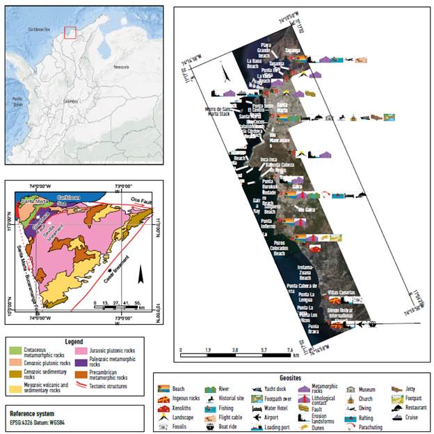
Source: Prepared by Ríos-Reyes, Castellanos-Alarcón and Manco-Jaraba 2018. Adapted and modified after Tschanz et al. 1974, adapted and modified after Google Earth 2018.
Figure 1 Left, geographical location of the study area (red color) in the SNSM. Right, mosaic of satellite images showing the northwestern foothills of the SNSM, 2018as well as the distribution and characteristic of geo-heritage sites.
The Sierra Nevada belt is the southeastern and oldest geotectonic province that consists of metamorphic rocks that reached the granulite to upper amphibolite facies during the Grenvillian orogenesis (Ramos 2010; Cordani et al. 2016). These rocks are cut by intrusive rocks and covered by extrusive rocks of Jurassic age, whereas Carboniferous and Late Mesozoic sedimentary rocks lie unconformably on the crystalline basement towards the southeast (Tschanz et al. 1974). The intermediate Seville belt is made up of paleozoic schists, amphibolites, gneisses, migmatites, and permian mylonitized granitoids (Tschanz et al. 1974; Mejía et al. 2008). The Santa Marta belt is the northwestern and youngest geo-tectonic province that is divided into two sub-belts: inner sub-belt of cretaceous imbricated metamorphosed volcanoclastic rocks that reached the greenschists to amphibolites facies, and outer sub-belt of mesozoic amphibolites, greenschists and phyllites separated by the lower to middle cenozoic Santa Marta Batholith (Mejía et al. 2008). The coastal region of interest in this work, that forms part of the Santa Marta belt, shows a complex geological history and has been of scientific interest in previous works (Tschanz et al. 1969; Tschanz et al. 1974; Mejía et al. 2008; Idárraga-García and Romero 2010; Montes et al. 2010; Cordani et al. 2016). The Santa Marta Fault System (SFSM) is the most important tectonic accident in the study area with easily recognizable geomorphologic evidences.
Geodiversity
Geoheritage site identification in the coastal region around Santa Marta and its geodiversity are very important for the selection of colombian heritage sites. Geosites are part of the geological heritage of a region, since they constantly reveal characteristics of international importance to elucidate their geological history (Koh et al. 2014). The potential geosites in the coastal region around Santa Marta are described briefly in Table 1. The proposed geosites have added value thanks to their attractive landscape and due to their uniqueness and beauty those can be used as geotourism resources. Geosites are illustrated through photographs of a didactic and explanatory form, revealing the most important geological agents that have acted in the modeling of the current landscape. They reveal the crystalline basement rocks, that preserve important evidence about the geological evolution of the SNSM and promote the opportunity to admire the fascinating coastal geomorphology. On the other hand, they contain a very important scientific, didactic and cultural value. They would be very useful to constrain the early evolution of the Earth crust, magmatic processes, tectonics and surface forces that contribute to such cortical evolution, the relationship between meta-morphism, magmatism, and deformation, as well as the tectonothermal history that has occurred in this orogenic belt, the partial fusion in the tectonic development of orogenic belts, including magmatic arches, exhumation processes, and tectonic denudation that have favored the extensive retrograde metamorphism that has affected the metamorphic rocks in its more recent history, the hydrothermal history of paleofluids that have circulated through the Earth crust, the mineral deposits associated to magmatism and metamorphism, the history of fluvial processes that have played an important role in modeling of the coastal landscape.
The geoheritage of the study area, that is of great attraction for regional development, is represented by the coastal geoforms (see figure 1) that are the result of processes of deposition and erosion on the coastline of the northwestern foothills of the SNSM, that are very useful to understand the coastal geomorphology, contributing to the geoscientific knowledge of this region to support those who must design strategies that contribute to the sustainable development and territorial management of this region of the Caribbean coast.
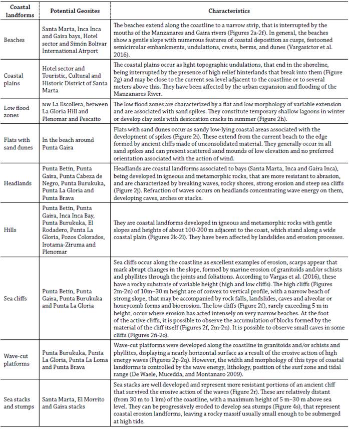
There are different examples of the geoheritage in the study area, with geomorphological (coastal landsforms), sedimentological (quaternary deposits), stratigraphical (complex stratigraphical relationships), paleontological (coral fossils), petrological (igneous and metamorphic rocks of the ancient crystalline basement), mineralogical (minerals of industrial interest), structural (Bucaramanga-Santa Marta Fault), and tectonic (neotectonic) interest. Among these, the coastal landforms deserve to be highlighted, as they reflect the result of the modeling of the coastal landscape that exists in this region.
The main coastal landforms recognizable in the coastal region around Santa Marta are illustrated in Figure 2 and depicted in Table 1. The geological characteristics of the coastal region around Santa Marta reveal several coastal environments from high energy rocky shorelines to sandy beaches, mainly highlighting its beaches and cliffs that are controlled by waves, tides, and currents. In general, it shows high relief erosional and low relief depositional landforms, as a result of the interaction of several geological processes. The erosional and depositional action of the sea waves along the coasts results in one of the most spectacular coastal landscapes (Magbagbeola 2011). However, Stiff (2018) considers that "the role of wave energy in the production of coastal landforms and landscapes must be taken into account". The deposition of sediments produced by the sea on the coast, together with the contribution of sediments from rivers, beaches or cliffs, are the cause of the formation of coastal deposition landforms (Nagle 2000), whereas the intense high energy surge results in the formation from coastal erosion landforms (Earle 2015). According to Sinitsyn et al. (2020), "wave action defines long- and cross-shore sediment transport, which in turn results in erosion or deposition at a given location".
Photography by Ríos-Reyes, Castellanos-Alarcón and Manco-Jaraba, February de 2018.
Figure 2 Coastal landsforms of the coastal region around Santa Marta Massif (Colombia).
The geotouristic values of this region will depend on the valorization of the sites of geological interest, that can be evaluated according to criteria as accessibility, representativeness, state of preservation, rarity, scientific knowledge, and education value (Solarska and Jary 2010; Brilha 2016).
Geoconservation
Conserving geodiversity
According to Gray (2005), "geodiversity should be conserved because it is valuable as a resource and that it is threatened by anthropogenic activity". The conservation of the geodiversity should be addressed for scientific, educational, and cultural interests. However, geoconservation must be focused on the implementation of actions aimed at preserving the elements that constitute the geological heritage of the region as a sustainable development strategy. However, as in other developing countries many important sites in Colombia, as the interest area, have been and are being damaged or destroyed, although, according to Gray (2019), this is something that also happens in developed countries, due to the lack of knowledge about geodiversity and geoheritage. Therefore, it is essential to hold workshops on geoconservation in the region of interest, making emphasize in educational purposes, considering that the beaches around Santa Marta suffer the ruthless and insensitive deterioration due to garbage and sediment discharges, discharge of sewage, presence of coal on beaches and affecting the quality of water, soil and air, and illegal occupation of coastal areas.
Geosites from the coastal region around Santa Marta should be preserved in their natural state taking into account that they are very sensitive to anthropogenic activity. Due to the characteristics of the cliffs tourist access must be restricted in high zones not only to protect the geoheritage but also to avoid accidents due to the strong waves. The geotours in boats could be hectic and therefore it is advisable to do it only on summer days. It is necessary to condition some areas or trails with basic facilities (installation of kiosks, banks, grills, picnic and camping sites, playgrounds, and restrooms) to provide the necessary infrastructure for tourists to take interpretive tours where it is possible to develop activities of geotourism and geoeducation for the purpose of geoconservation of sites of geological interest. Geodiversity management should focus on the conservation of geosites, contributing to the transfer of scientific knowledge from geoeducation to the sustainable development of local communities (Gray 2004).
From the educational point of view, one of the most important justifications to carry out the protection of sites of geological interest is to preserve them for the development of geoeducation activities and training of future geoscience professionals. Geosite assessment is very useful to identify the geosites with highest geotourism potential (Pazari and Dollma 2019) and to justify the synergy between geoconservation and the corresponding activities in the process of managing the development of geotourism (Tomic et al. 2020), that can be considered in future surveys at the coastal region around Santa Marta (Colombia).
Regulating the conservation of geodiversity
According to Crooks (2004), the degree of vulnerability experienced by coastal cities as the Touristic, Cultural and Historic District of Santa Marta (TCHDSM) will depend on the rise of the sea level as a consequence of climate change and the capacity of its inhabitants to adapt to these changes. Nonetheless, it faces strong pressure for development and is seeking to become a sustainable city, whose challenges are facing environmental deterioration of urban rivers, inequality and poverty, informality, violence and insecurity, mismanagement of public finances, and climate change. In relation to sustainable tourism, the TCHDSM has been growing, but has not been empowered by the opportunities offered by tourism. The challenges to become a more competitive place and world class destination should be infrastructure development, international connectivity, governance and cooperation between national and local governments, security for the tourist, human resource training especially in bilingualism, certification of beaches, recovery of the historic center, and improvement of the pier for arrival of cruises. On the other hand, during the last years the degradation of the landscape and coastal erosion have progressively increased affecting the geoheritage and generating a negative socioeconomic and environmental impact. It constitutes a high threat not only for the TCHDSM but also for the Colombian Caribbean coast. "Coastal geomorphology is the study of the morphological development and evolution of the coast as it acts under the influence of winds, waves, currents, and sea-level changes" (Leatherman, Todd and Nicholls 1994).
This region has been affected by coastal erosion, this is a natural process that generates the reduction of the beaches and the retreat of the dunes and cliffs. However, anthropogenic factors, as intensive quarrying of sand and gravel for buildings and marine protection barriers, have also contributed to accelerate the erosion process despite the beauty that the sea cliffs represent, they have a high percentage of risk, since there are no signs to warn tourists about the height and speed of the winds that can cause accidents to tourists. Some buildings installed on the sea cliffs could be at risk in case of a collapse. The impact of these factors has increased due to the lack of policies focused on the management of coastal zones. The anthropic action also poses a threat, since tourists who do not follow the principles of geoconservation can cause damage to the geological heritage or to the environment by inadequate waste disposal. Therefore, it is important to promote the development of protocols aimed to regulate the conservation of geodiversity as a sustainable development strategy for this region.
Working with local communities
The transitory nature and inequality of the relationship between tourists and local communities, as well as linguistic barriers, makes more difficult to develop a knowledge transfer. However, working with local communities would be very useful to help tourists appreciate the diverse qualities of the geoheritage and understand the need for its conservation. According to Fülöp and Kovacs (2010), "it is necessary to make local communities aware of the importance of geodiversity, training them to contribute to their conservation", since their lack of knowledge is one of their greatest threats (Gray 2004; Wang, Tian, and Wang 2015). One of the best ways to raise awareness in local communities about the value of geoheritage is through geoeducation (Van Loon 2008). Obviously, the challenge of such an initiative is to assume that this represents something still unknown to the local communities. Therefore, it is fundamental to undertake the development of projects with territorial relevance as a novel strategy for socioeconomic development through geotourism, conservation and education, sensitizing about geoheritage, starting with the creation of an visitor interpretation center for the dissemination of the geosciences and activities that take place in the territory, permanent exhibition with explanatory panels, backlit displays, models and interactive panels to offer tourists an overview of the geoheritage of the coastal region around Santa Marta and its conservation, as well as the inclusion of local communities in the sustainable use of geological heritage.
Geotourism
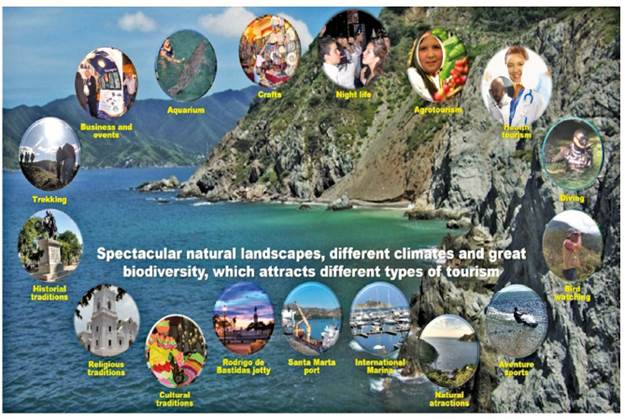
Globally, geotourism is an activity that has been growing rapidly, as a consequence of the growth in supply and demand. It represents a novel and innovative strategy, at least for the colombian context, as it contributes to the socioeconomic and environmental development of the caribbean coast region, starting from the use of its geological heritage and wonderful coastal landscape, promoting tourism through geosites, geoconservation, understanding of the earth sciences through geoeducation, promoting environmental and cultural appreciation, benefiting of local communities, enjoying natural and human contexts from its use as a resource thanks to its scientific, natural, cultural, recreational, aesthetic, and didactic value (Dowling and Newsome 2010). Geotourism should include not only the geodiversity of a territory as part of its natural heritage but also its biodiversity represented in its rich fauna and flora of the region, as well as its cultural heritage past and present, non-living, and built. According to Taylor and Lennon (2011), cultural landscapes are literally an imprint of human history that can tell us, if we care to read and interpret them, something about the achievements and values of our predecessors, and they are a record of past and present actions. The relationship between geotourism and other forms of tourism is shown in Figure 3.
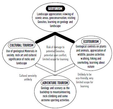
Source: modified after Dowling and Newsome (2010).
Figure 3 Integration of different types of tourism.
The coastal region around Santa Marta (Colombia) shows a large variety and complexity of potential geosities with geological, geomorphological, sedimentological, stratigraphical, paleontological, petrological, mineralogical, structural, and tectonic interest, as well as its wonderful coastal landscapes (Saenz-Reyes, Ríos-Reyes, and Castellanos-Alarcón 2017), that makes it a region of great scientific, educational, and aesthetic value. However, it is very important to develop a responsible tourism to encourage tourists to experience, learn, and enjoy the natural and cultural heritage of his region promoting in the visitor, regardless of their origin, to assume favorable attitudes towards the geoconservation of this territory. On the other hand, the tourist attractions of the region should be promoted in an integral way through their natural and cultural heritage, attracting a greater number of tourist markets, each of which will leave the visitor with a greater appreciation of the region.
Below, we highlight some of the factors that explain why geotourism in the region of interest in the present study would be successful. The coastal region around Santa Marta includes the TCHDSM. The geological heritage inserted in the urban area, as coastal landforms, among others, can also be part of urban geotourism that becomes an interesting alternative to develop urban geological itineraries as reported in the geoscience literature (Palacio-Prieto 2015; Habibi et al. 2018), usually in the Historical Centers of the main tourist cities (Schaefer and Farias 2020) as Santa Marta, that is the oldest city in Colombia and was founded by the spanish conqueror Rodrigo de Bastidas on July 29, 1525. Due to the influence of factors as relief and the sea-continent interaction, among others, it presents a tropical climate, with high relative humidity, being hot with a lot of cloudiness in winter and warm with partial cloudiness in summer, although the sea breeze helps to soften the temperature.
The particular characteristics of this region allow outdoor activities throughout the year, excellent access to the different places of geological interest, the wide range of services (bars, restaurants, accommodation, transportation, telecommunications, coastal trails, pedestrian access routes to the coast, ports of loading and passenger boarding, etc.) that favors the development of geotourism. It has great appeal not only for its rich biodiversity but also for its cultural and historical sites. The magic of discovering one of the most spectacular coastal regions in Latin America allows the visitor to observe its unique architectural heritage, wonderful coastal landscapes and historical, cultural, and religious heritage, with its colonial treasures, making this an ideal destination not only for leisure and recreation but also for the development of scientific and learning activities.
The Camellón de Rodrigo de Bastidas (Figure 4a) is one of the most important tourist attractions of the city of Santa Marta where it is possible to make a pleasant pedestrian walk from the International Navy of Santa Marta (Figure 4b) to the south to the Port of Santa Marta (Figure 4c) to the north. The International Navy of Santa Marta has two spurs, one public and one private, that contributes to stop the instability that occurs on the beaches, preventing the continuation of coastal erosion in the section intervened. The public spur for the enjoyment of the community and national and foreign tourists, with commerce, restaurants, docks, public spaces, maintenance, and event area, tourist information, etc. The private spur for the users of the Navy that provides inherent services to the nautical activity of yachts and sailboats, as commerce, restaurants, nautical store, operation of the Navy, docks for berthing of the boats with services of water, light, television, Internet, heliport, etc. Along the pedestrian walk, there are different sculptural works in tribute to the culture of the Tayrona ethnic group (Figure 4d) and to the heroes, among those the statue of Rodrigo de Bastidas (Figure 4e), founder and conqueror of Santa Marta, located in front of the Plaza del Libertador Simón Bolívar (Figure 4f). The Cathedral of Santa Marta (Figure 4g) is famous because the ashes of Rodrigo de Bastidas are conserved in the mausoleum and the remains of the Liberator Simón Bolívar conserved there for some time. The tourism dynamics, fisheries, and coastal phenomena make the coastal region around Santa Marta a particular site in terms of its marine wealth (Figures 4h-4i). The beauty of the landscape and the beaches (Figures 4j-4k) a place of great tourist attraction where outdoor tourism, sports and health are practiced. Taganga has a boardwalk where a variety of typical seafood is offered, where artisans gather to make handicrafts or typical elements with different colors and designs (Figure 4!). The indigenous communities of the SNSM are represented by the Kogi (Figure 4m), Wiwa, Kankuamos, and Arhuacos tribes, that and empanada. Fruits with exotic characteristics can also be tasted here. There is an excellent lodging offer for the development of congresses, conventions, business events, family or group tourism, etc., with all the comforts and facilities that are required, including wet areas and recreation areas for rest, as well as other complementary services (Figure 4ñ). Finally, this caribbean region presents very particular traditions and customs deeply rooted in its inhabitants, many of an ancestral nature that have been of pride at the national level and even, being representative of one of the cultures of Colombia (Figure 4o).
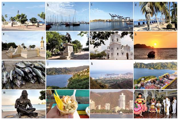
Photography by Ríos-Reyes, Castellanos-Alarcón and Manco-Jaraba, February 2018.
Figure. 4 Tourism attractions along the coastal region around Santa Marta Massif (Colombia).
According to Dickson, Gray, and Mann (2008), outdoor experiences have evolved from necessity to recreation, offering alternatives of interaction of tourists with nature and among those who are part of these. Several outdoor activities can be developed in the coastal region around Santa Marta, which include diving or snorkeling, which allows to admire the fascinating variety of corals and, of course, of fish of different colors, among other marine species, banana, kayaking canoeing, jet skiing, bodyboarding, fishing, flying cable, paragliding, mountain biking or trekking (Figure 5).
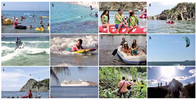
Photography by Ríos-Reyes, Castellanos-Alarcón and Manco-Jaraba, February 2018.
Figure 5 Outdoor adventure, sports and health activities of the coastal region around Santa Marta Massif (Colombia).
Local communities must be informed about the existence of the natural and cultural heritage in this region and the need to contribute to its conservation, to make it a unique place for enjoyment of the tourists, with easy access by foot and boats, also near to the urban center. The interest of many people, institutions, and companies that have worked in this region has motivated the need to undertake actions aimed at protecting the natural and cultural heritage of the territory. The tourist information centers can provide tourists who visit the region a location with information on the places of interest, lodgings, restaurants, museums, recreation options, and shopping centers, as well as special events during their stay, maps, and other items relevant to tourism, so that they can take the advantage of their vacations in this region of the Colombian Caribbean. These centers are fundamental in the organization of geotourism activities at the TCHDSM through guided visits in conjunction with private companies. The coastal landscape modeled by the continuous action of the sea, reveals at least 60 Ma of the geological history of this region, where through different outcrops of rock along roads and cliffs it is possible to carry out a reconstruction of processes geological events that occurred there. Therefore, the creative and innovative development of georoutes (Saenz-Reyes, Ríos-Reyes, and Castellanos-Alarcón 2017) will help to integrate and promote the different existing resources along the coastal region around Santa Marta, that must be accompanied by a brand that promotes all the geotours to offer under high quality standards to develop geotourism in this region as a novel strategy for sustainable development. It will be possible for the tourist to venture along the shores of the coastline through a boat ride to enjoy not only the landscape but also numerous coastal outcrops on its cliffs, being able to access by foot visits to different geosites. However, it is possible to combine terrestrial and maritime visits to enjoy a surprising geology in sites of geological interest. This region has great potential for the development of geotourism that could find an emerging market for this activity of interest for foreign tourists, that should lead to increasing local competition to meet that demand under high standards in the offer of tourist services.
Geotourism constitutes an experiential strategy that allows you to enjoy and learn about the natural and cultural heritage of the region, stimulating favorable attitudes for its conservation. However, it is very important to promote the development of responsible tourism with nature and respecting international standards of sustainability. Globally, different geotourism initiatives are being developed, mainly as a sustainable development tool with the participation of local communities. The connection between geotourism and several tourism attractions in this important coastal region of Colombia has a fairly close relationship (Figure 6). There is no doubt that the scientific and landscape value of the geological heritage of this region can turn it into a tourist resource of great attraction.
Geoeducation
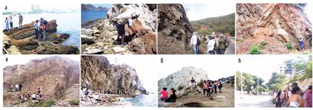
The Earth sciences allow us to understand the natural phenomena that have contributed to the evolution not only of our planet but also of life. Undoubtedly, the professionals of the Geosciences must fulfill a social function, carrying out the transfer of knowledge to local communities. Social inclusion will also allow the development of educational programs and conservation of the geological heritage, respecting the links with other natural and cultural heritage values that can be associated with tourism and recreational activities, promoting citizen empowerment and responsible public use. Therefore, to promote geotourism, it is necessary to encourage the economy of the region, to allow local communities to adapt to changes in their environment, to diversify tourist services, to implement the use of explanatory panels at geological sites, to design geological routes for the enjoyment of the landscape where the geology is the protagonist, taking the tourists to make a fantastic trip through the geological heritage of this region of the Colombian Caribbean and contributing to a sustainable development. Geoeducation, that has attracted the attention of scientists and educators (Lewis and Hampton 2015), plays an important role in integrating local communities to improve their quality of life, providing social equity. A better understanding of the geosciences and their field of action contributes to the sensitization on geoconservation, greatly important to ensure the protection of the Earth. Geoeducation is a strategy that contributes to the conservation of this region of the Colombian Caribbean and represents the most effective way to guarantee the contribution to the preservation of the environment in the long term, providing a combination of understanding, attitudes, and skills. It is necessary to organize activities (Figure 7) to promote the transfer of geoscientific, environmental, historical, and cultural knowledge to school's students. Through different geotrails, tourists can enjoy and experience the coastal landscape of this region, taking advantage of geodiversity and its synergy with biodiversity and historical and cultural aspects, and learning about the importance of contributing to the conservation of geoheritage. It is possible to implement boat routes to link the geosites with sites of special attraction for the observation of fauna and flora, as well as cultural and historical values. The bilingual guides for the development of geotourism are essential to ensure a quality offer, however, the TCHDSM, currently does not have this type of guides, therefore, it is necessary to undertake training days for guides of the region to reach the level of bilingualism and geological information to meet the needs of tourists. In terms of activities, several undergraduate Geology students can participate as guides at each one of the geosites, explaining scientific concepts to tourists and providing for the use of typical instruments used for fieldwork activities. As intended, tourists can receive an exploring-like experience, complemented, in addition, with other disciplines.
Geotourism and its socioeconomic and environmental impact
In recent years, in the TCHDSM the main economic activities include social, commercial, hospitality and restaurant services, with the presence of numerous national and foreign tourists, that has been accompanied by an accelerated demographic explosion, mainly in its urban area. This scenario of tourism and population growth would suppose the progress and development of the region; however, poverty and economic and social inequalities have increased there. Nevertheless, despite being an area with a disadvantaged socioeconomic situation, the coastal region around Santa Marta (Colombia) has in its territory a valuable natural and cultural heritage that projects towards a geoconservation strategy based on the development of geotourism and geoeducation. Although, it is necessary that the municipal administration, the Magdalena Government, the Republic of Colombia, and the environmental authorities, generate more effective solutions that allow the articulation and commitment of the different governmental, economic, social sectors, territorial entities, and local communities, profiled this region to develop a real tourism offer, of quality, that generates more socioeconomic and environmental benefits.
The socioeconomic repercussions of this depressed region are very negative, and, according to Pulido, Lagar, and García (2011), lead to the loss of the active population, lack of business initiatives, leading to the weakness of the productive fabric, and increased unemployment and subsidiarity. The current situation in this region merits an intervention in a way that strategies are designed to reactivate the productivity and slow down the regressive trend of the population, for this it is necessary to promote the development of geotourism in the region in accordance to the potential of the territory, contributing to the sustainable socioeconomic development of the region.
Geotourism could become the socioeconomic engine of this region, being a generator of employment, investment and business opportunities. This region has enormous potential for promoting geotourism initiatives through the geological heritage inserted in the urban area, with different outcrops, cliffs or abrasion platforms that offer a continuous geological record covering 125 million years. Therefore, financial support through public and private sector investment should be focused on improving geotourism infrastructure and resources, technical studies, signaling, design and construction of geotrails and viewpoints for geotours, tourist guides, tourist maps or websites, promotion and management, among other aspects, to carry out sustainable tourism with good practices in geotourism that will directly and indirectly benefit this region. On the other hand, it is very important to establish a link with local tourist activities, such as boat trips, bird watching or cultural activities, sale of local products, either through direct marketing or product labeling, with the economic incentive that it supposes for these businesses previously established.
We emphasize in this work that through the participation of local communities in innovative strategies to promote the local economy and public knowledge about geology, geotourism can improve the quality of life of local communities and stimulate the local economic growth. Several strategies can be applied to promote it, including the production of products based on the geological elements, that combine traditional products with new concepts (Torabi, Coelho, and Costa 2011), as shrimp geococktails, cliff cakes, coral chocolate, and bread, fruit geosalads, jewelry with sea shells, coconut bark, wood and talc-based crafts, indigenous crafts. Souvenirs should be based on the geological heritage of the region to promote local products, improve the local economy and carrying out geoeducation activities. On the other hand, tourism services can also be offered by georestaurants, georesorts, and geocompanies that promote geotourism, although geoproducts also include visits to production units, tastings and workshops as well as presentations, fairs, festivals, specialized markets, trade shows for professionals, etc. (Rodrigues, De Carvalho, and Jacinto, 2017).
Geotourism enhances conservation and development by providing environmental and socioeconomic benefits to the coastal region around Santa Marta (Colombia). The economic benefit of geotourism is reflected in the generation of direct jobs, the demand for hotels and restaurants, and the sale of handicrafts.
The development of an appropriate economic policy by the government promotes the socioeconomic improvement of a region through the creation and/or modernization of small traditional local industries, the increase in the tourist offer and the protection of the environment and natural resources (Pulido Fernández, Lagar, and García, 2011).
Conclusions
The present work promotes awareness of the importance of preserving the natural and cultural heritage of the coastal region around Santa Marta. The scientific, educational, and aesthetic value of the geological heritage can turn it into a tourist resource important enough to become one of the main attractions of this region, allowing the visitors to know it, and stimulating attitudes favorable to its conservation. However, those who can contribute to the preservation of this heritage wealth are the local communities from their sustainable use to obtain economic benefits. In this way, the geoconservation of this region is closely related to the several benefits that can find local communities. Besides, it is essential to disseminate, teach, and value the geological heritage as an important part of the natural and cultural heritage of this region for its management by a responsible and respectful society of its environment, promoting its conservation and protection. Therefore, it is necessary to establish strategic alliances between local communities and public and private institutions of preschool, basic, middle, and high education, tourism businesses, restaurants and housing, governmental and non-governmental organizations, etc., along with the construction of plans focused on the preservation and management of its patrimonial wealth. The natural and cultural heritage proper of this territory must be maintained as sites of interest that can be transferred to future generations. In this way, the development of geoeducation activities is necessary in response to the need for the use of natural and cultural resources to be identified and classified by geoscience professionals, that is important for socioeconomic development, where geoeducation plays a fundamental role. Geoeducation can be promoted, allowing the development of activities for the transfer of geoscientific knowledge to the tourists through geosites, museums, information centers, guided tours, excursions, maps, educational materials, exhibitions, workshops, etc. Geotourism has emerged as a strategy for sustainable development of a region based on the dissemination of its geological heritage from its use as a resource thanks to its scientific, educational and aesthetic interest, generating several social and economic benefits, including revenue creation, employment opportunities for local communities, social inclusion, and infrastructure development. It integrates the principles of sustainability, responsibility, and quality in the tourism sector, through actions in favor of environmental conservation, the promotion of culture and the activation of the socioeconomic situation of the region. Geotourism can also generate the brand of quality in the national and international scope; the increase in number of tourists; the improvement of the quality of life of local communities; the significant employment generation for traditionally excluded sectors; the development of various economic, business, cultural, and tourist activities; the geoconservation and the eco-friendly management. However, it is necessary to establish strategic alliances with educational institutions, tour operators, hotels and restaurants, non-governmental organizations, companies of unique goods and so forth to prepare a development plan that promotes the geoconservation of geosites.

