


Serviços Personalizados
Journal
Artigo
 Inglês (pdf)
 Artigo em XML
 Referências do artigo
 Enviar este artigo por email
Indicadores
-
 Citado por SciELO
 -
 Acessos
Links relacionados
-
 Citado por Google
 -
 Similares em
SciELO
Similares em
SciELO -
 Similares em Google
Compartilhar

 Permalink
ORINOQUIA
versão On-line ISSN 0121-3709
Orinoquia vol.17 no.2 Meta jul./dez. 2013
Definition of Agricultural Management Units in an Inceptisol of the Casanare Department (Colombia)
Definición de Unidades de Gestión Agrícola en un Inceptisol del departamento de Casanare Colombia
Definição de Unidades de Gestão Agrícola em um Cambissolo do departamento Casanare (Colômbia)
Ricardo A. Peña-Venegas1
Yolanda Rubiano-Sanabria2
Andrés J. Peña-Quiñones3
1 Docente de la Facultad de Ciencias Agropecuarias, Universidad de La Salle, Yopal, Casanare. Email: ripena@lasalle.edu.co.
2 Profesor Asociado de la Facultad de Agronomía, Universidad Nacional de Colombia, Bogotá.
3 Investigador de la disciplina de Agroclimatología - CENICAFÉ, Chinchiná, Caldas.
Recibido: Marzo 20 de 2013. Aceptado: Julio 26 de 2013
Abstract
Sixty-four representative samples of the 20 cm of shallow soil were taken in an Oxic Dystrudept of the Eastern Mountain Ridge foothills (Casanare, Colombia), on a 58-hectare farm using a nested sampling of four levels. The measured properties correspond to those that determine crop yields. The principal components technique was used for data analysis. Thus, we generated a variable to classify soil with a comprehensive approach called First Principal Component (PC1), which explained 78% of the variation found in the data of the properties that affect specifically crop production. PC1 proved to be a regionalized variable and interpolated via Kriging on the map of the farm. The positive and negative values of this new variable (PC1) determined the UMH for the establishment of commercial crops in the farm.
Key words: Variability, Soils, Principal Component Analysis, Site-Specific Management.
Resumen
En un Oxic Dystrudept del piedemonte de la Cordillera Oriental (Casanare, Colombia), en una finca de 58 hectáreas, se tomaron 64 muestras representativas de los 20 cm superficiales del suelo utilizando un muestreo anidado de cuatro niveles. Las variables medidas corresponden a aquellas que determinan los rendimientos de los cultivos. La técnica utilizada para el análisis de los datos fue la de componentes principales; en ese sentido, se generó una variable para clasificar el suelo con un enfoque integral, llamado Primer Componente Principal (PC1), la cual explicó el 78% de la variación encontrada en los datos de las variables que inciden de manera específica sobre la producción de cultivos. El PC1 demostró ser una variable regionalizada y se interpoló vía Kriging sobre el mapa de la finca. Los valores positivos y negativos de esta nueva variable (PC1) determinaron las UMH con miras al establecimiento de cultivos comerciales dentro de la explotación.
Palabras clave: Variabilidad, Suelos, Análisis de Componentes Principales, Manejo por Sitio Específico
Resumo
Num Oxic Dystrudept de piedemonte da cordilheira Oriental (Casanare, Colômbia) numa fazenda de 58 hectares, foram tomadas 64 amostras representativas dos 20 cm superficiais do solo utilizando uma amostragem aninhada de quatro níveis. As variáveis medidas correspondem a aquelas que determinam os rendimentos das culturas. A técnica utilizada para a analise dos dados foi de dos componentes principais, nesse sentido de gerou uma variável para classificar o solo com enfoque integral, chamado Primeiro Componente Principal (PC1), a qual explicou o 78% da variação encontrada nos dados das variáveis que incidem de maneira especifica sobre a produção de cultivos. O PC1 demostrou ser uma variável regionalizada e foi interpolada via Kriging sobre o mapa da fazenda. Os valores positivos e negativos desta nova variável (PC1) determinaram as UMH para o estabelecimento de culturas comerciais dentro da exploração.
Palavras chave: Variabilidade, Solos, Analise de Componentes Principais, Manejo por Sitio Específico.
Introduction
There are many elements, components and variables that need to be known for making decisions in agricultural enterprise. Good decisions can only result from an appropriate analysis and interpretation of data, turning it into information, which is turn into action (Winograd et al., 1998). Therefore, the basis of information that can be turned into action to increase competitiveness and sustainability of farms is knowledge of soil resources through the analysis of spatial and temporal distribution of physical and chemical characteristics.
Precision agriculture allows the use of a wealth of information to turn it into action. It definies localized management practices based on the spatial variability of soil, Variation affects the productivity of crops is a followed premise (Schepers et al, 2004, Cox et al, 2003). This means that it is necessary to know the variability patterns and their magnitude, in order to implement management differentiated by specific sites, it is necessary to know the variability patterns and their magnitude, which can be studied through geostatistics that allow mapping and defining homogeneous areas. The area of the greatest development in precision agriculture site-specific nutrient management, also called "variable rate technology," which corresponds to the variable application of fertilizers doses according to the fertility level of each sector within the field. This means that the work is not necessarily carried out with a single dose of fertilizer, but with as many doses as significantly homogenous areas exist in the exploitation (Ortega and Flores, 1999).
This technology allows having a more efficient management of crops, not only from the economic but also from environmental point of view (Brouder et al., 2001). This paper evaluates the spatial variability of physical and chemical attributes of soil as a basis for developing a SSM (Site Specific Management) pilot project in the Llanos Orientales (Tauramena, Casanare).
Methodology
Characteristics of the study area
This research was conducted in the Orinoco region in eastern Colombia, on a farm of 58 ha, located in the village Jagüito, Tauramena municipality, south west of Casanare department, about 5° 01' north latitude and 72° 45' west longitude (Figure 1).
The study area is located on a relief zone slightly flat with dominant slope (1-3%), it corresponds, according to Holdridge, to a Tropical Rain Forest (TRF) with an annual average rainfall of 3000 mm (IGAC, 2002). The landscape corresponds to the foothills, the type of relief to a terrace range and the land form to the plane of the terrace range. The soils of this area were characterized according to USDA (2006), as Oxic Dystrudept, fine Loamy, kaolinite, underactive and isohyperthermic; moderately deep phase with 30% in the unit and deep phase with the other 70% approximately. They are characterized by having from a sandy loam to a clay loam texture, from very shallow to very deep effective depth limited in some areas by stoniness. They are well drained, with low base saturation and low capacity of cationic exchange. Stranglehold of quartz and kaolinite was found in the sand and clay fraction, indicating a very low potential and current fertility (Peña, 2006).
Sampling and soil analysis
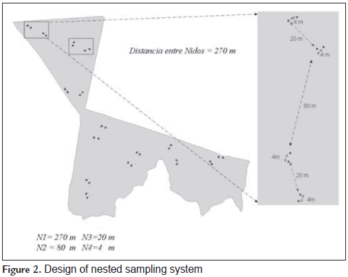
A nested sampling was used with the same mapping unit with four levels corresponding to the distances among samples, ie, 270, 80, 20 and 4 m for the spatial study of some physical and chemical properties of soil. The distances were arbitrary, selected on the criteria described by Jaramillo (2002). The results of previous studies were developed by Ovalles and Rey (1995), Madero (2002), Lozano (2004) and Rubiano (2005), with some adjustments, due to the particular shape of the area. The experimental design corresponds to a factorial model 8x2x2x2 = 64 sites, where the first level (270 m) has eight repetitions, while others only had two levels (Figure 2).
It was made based on the procedures established by the IGAC (1979), in each of the selected points determinations of soil parameters that affect crop yields, according to literature (Table 1).
Statistical methods
Using the program JMP v 5.1 (SAS Institute Inc., 2001) descriptive statistics were determined, i.e., mean, standard deviation, variance, coefficient of variation, median, skewness, kurtosis, minimum and maximum values of the variables under study. Subsequently, we analyzed the spatial behavior of each of them through geostatistical analyses using the program GS+ v 7.0 (Gamma Design Software, 2005), which found half of the maximum distance between two sampling points as a range to calculate semivariance.
In order to calculate the multivariate index used to determine homogeneous management units we used the PRINCOMP procedure of SAS v 8.1 (SAS Institute Inc., 2001). The first principal component has the quality to be a variable that is the best linear combination of the original variables (Table 1) and summarizes the maximum variability of the population under study. After generating the multivariate index, we proceeded to make the geostatistical analysis of the First Principal Component, including the interpolation (Kriging Spot) for the subsequent localization of the homogeneous zones with ArcGIS 9.1 (ESRI, 2004).
Results and discussion
Descriptive statistics and geostatistical analysis
Table 2 shows the mean content of K in soil is low (0.11 cmol(+).Kg-1), compared with the amounts needed for good crop growth reported in the paper published by the ICA (1992). That is why the availability of this element could become a major constraint to agricultural production in this soil. However, this is the normal behavior of K and other cations in soils with high contents of quartz and kaolinite, which is associated to low values of CICE (2.58 cmol(+).Kg-1). This can be explained by the predominance of the sand fraction (A) that in these soils is greater than 60% (60.84%). Aluminum has high values (2.17 cmol(+).Kg-1) compared to the value of the CICE. Therefore, it is possible to state that the exchange complex is dominated by the dynamics of this element. The bulk density, with an average value of 1.51 g.cm-3, can be considered limiting for the normal root development in accordance with the reports of Hoyos et al. (2004), for light textured soils of the Eastern Plains of Colombia. The CO values (1.30%) are similar to that reported for soils in the high plains (Rubiano, 2005), alluvial soils and even the foothill soils of the Meta department (IGAC, 2000). It can be considered as an average value in this region.
The physical properties (A and DA) showed the lowest coefficients of variation (13.29 and 6.29). However, these variations may represent significant effects on crops, such as the high values of DA found (up to 1.66 g.cm-3) are strongly limiting for agriculture according to Lal (1994). Therefore, the management of these soils must be differentiated from soil management with low DA (1.16 g.cm-3) found in some sectors. Those sectors are related to high gravel content. The CO is the chemical attribute that has the highest coefficient of variation (45.40), with values ranging from 0.49% to 3.73% on the lot. It is explained by the different management that the study area has had. It has grown peanuts, but there are also natural pastures. The coefficient of variation for Al, K and the CICE is similar, largely explained by the soil mineralogy and the differential uses of land surface.
Table 3 shows the experimental semivariogram attributes for each of the properties analyzed in this work. This table also shows, out of all attributes analyzed, the spherical model was the best fit to the experimental models (physical and chemical). It was also reported by Oliveira et al. (1999) and Verges (2004) in another type of soils. K, Al and A have a ratio nugget/sill (Prop) that, according to Cambardella et al. (1994), represents a strong spatial dependence. DA, CICE and CO have a moderate spatial dependence. The relationship between semivariance of the attributes and sampling distance best fits the spherical model (higher r2) on those variables that have greater spatial dependence. In turn, these variables have high determination coefficients in cross validation (r2cv), unlike the variables that have moderate spatial dependence. This means that the maps generated for properties with high spatial dependence are more accurate than those generated for variables with moderate spatial dependence.
Figure 3 shows the interpolation of the variables analyzed via point kriging. There are sites on the farm where high values of an attribute match the highest (or lowest) values of other variables, as seen in the area marked with the circle. It shows the variables are strongly related.
Analysis of Principal Components
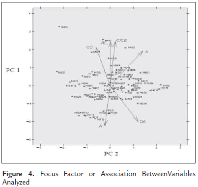
Figure 4 shows every variable has a great weight within the first principal component (PC1). That is why it collects about 80% of the variance contributed by all the variables (Table 4). The same figure shows there is a strong positive relationship between variables Al and CICE. It is evidenced by the closeness of the vectors that identify each one. A similar behavior happens between Al and CO, but with a greater distance. The vectors for the variables A and Al are located in the opposite way. A and CICE indicates a strong negative relationship between these variables.
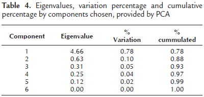
According to principal components analysis, PC1 was constructed taking into account weights of each variable in the global variance, so that PC1 is given by the following equation, where each variable is standardized:
PC1 = [A (-0.42)] + [DA (-0.37)] + [CO (0.39)] + [CICE(0.45)] + [K (0.35)] + [Al (0.45)]
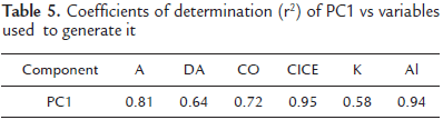
Low values of PC1 indicate a high percentage of A and DA and low values for CICE, CO, Al and K. High values of PC1 are related to the opposite behavior (low values of A and DA and high values of CICE, CO, Al and K). Table 5 shows the proportion in which PC1 is explaining the behavior of each variable in the field, through the coefficient of determination. It indicates a very good estimate of r2 values between 0.58 and 0.95.
Generation of Management Units
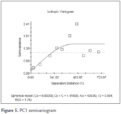
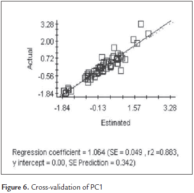
The geostatistical analysis of PC1 shows it has spatial dependence. It can be "mapped" reliably through Kriging (Figures 5 and 6). The estimate obteined by geostatistical analysis allows to propose management units identified in the initial purposes of this research.
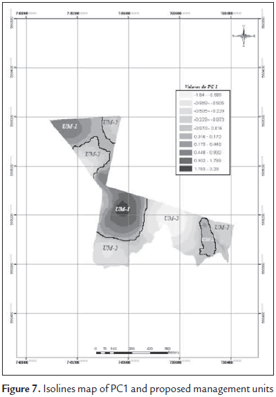
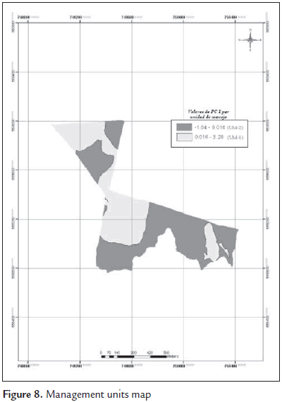
Figures 7 and 8 show two proposed management units (MU-1 and MU-2) based on the values of PC1. MU-1, characterized by having PC1 values greater than zero (0), has an approximate area of 25 ha. It has soils with minor sand content (44 to 60%), lower bulk densities with values between 1.2 and 1.5 g.cm-3. They are considered as non-limiting or moderately limiting according to the criteria set out by Lal (1994). The contents of CO, CICE, K and Al are the highest in the study area. The opposite behavior is observed in the variables of MU-2, characterized by PC1 values below zero (0), resulting in high values of A and DA and lower for CO, CICE, K and Al. Percentage of A oscillates between 60 and 74. DA's is between 1.5 and 1.65 g.cm-3, the latter considered by Lal (1994) as a strong to a very strong constraint. This unit has an approximate area of 33 ha.
Conclusions
The general idea of considering lots, plots, farms and regions as places where the soil is homogeneous has often led to wasted efforts in pursuit of information. It happens because the soil attributes characteristics are averaged and this datum is used as a basis for decision making. The present study showed that the soil varies considerably in a single mapping unit, in the same region and in the same premises (smaller than 60 hectares). It is possible to distinguish two different management areas with a agricultural production view.
With DA as indicator, this unit does not have limits for the rooting of more crops. That is why mechanization should be done with minimum tillage in order to preserve soil structure. The CO levels indicates that the application of organic matter before planting should be in smaller amounts than in MU-2. However, its application is critical in both due to low values of CICE. MU-1, due to high Al values . To reduce saturation of this element will require greater amounts of chemical amendments, compared to MU-2.
MU-2 DA values show a strong constraint on pineapple rooting. Thus, a rigid tooth chisel should preferably be used to break the surface layer, taking care of over mechanization due to these soils susceptibility erosion. Irrigation is another aspect affected, compared with MU-1, as it surely must have greater frequency, in smaller amounts, due to the higher content of sand in this management unit.
References
Brouder BS, Hofmann B, Reetz HF. 2001. Evaluating spatial variability of soil parameters for input management. Better Crops. 85(2):8-11. [ Links ]
Cambardella CA, Moorman TB, Parkin TB, Karlen DL, Novak JM, Turco RF, Konopka AE. Field- scale variability of soil properties in central Iowa soils. Soil Sci. Soci. Am. J. 1994: 58: 1501-1511. [ Links ]
Cox MS, Gerard PD, Wardlaw MC, Abshire MJ. Variability of selected soil properties and their relationships with soybean yield. Soil Sci. Soc. Am. J. 2003; 67(4): 1296-1302. [ Links ]
ESRI. 2004. ArcGIS Software, versión 9.1. http://www.esri.com. [ Links ]
Gamma Design Software. 2004 (5). GS+. Geostatistics for the environmental sciences. Gamma Design Software. Plainwell, Michigan USA. [ Links ]
ICA. 1992. Fertilización de diversos cultivos. Quinta Aproximación. Produmedios, Santafé de Bogotá, pp 1-26. [ Links ]
IGAC. 2002. Manual de códigos. Atributos de los levantamientos de recursos de tierras. Subdirección de Agrología, Bogotá. 95 p. [ Links ]
IGAC. 2000. Estudio General de Suelos del Departamento del Meta. Bogotá. 500p. [ Links ]
IGAC. 1979. Métodos analíticos del Laboratorio de Suelos. Subdirección de Agrología, Bogotá. 664 p. [ Links ]
Jaramillo DJ. 2002. Introducción a la ciencia del suelo. Medellín: Universidad Nacional de Colombia, sede Medellín. Facultad de Ciencias. 649 p. [ Links ]
Lal R. 1994. Métodos y normas para evaluar el uso sostenible de los recursos suelo y agua en el trópico. SMSS Monografía técnica No. 21. Departamento de Agronomía, Ohio StateUniversity. Columbus, Ohio.96 p. [ Links ]
Lozano JF. 2004. Validación de índices para conductividad hidráulica y compactación en algunos suelos del valle del cauca. Tesis de grado. Programa de Maestría en Ciencias Agrarias. Universidad nacional de Colombia, Sede Palmira, escuela de Postgrados. 124 p. [ Links ]
Madero EE. 2002. The Cartography of soilcompaction. En: Memorias del XI Congreso Colombiano de la Ciencia del Suelo. Cali. [ Links ]
Oliveira JJ, Chaves LHG, Queiroz JE, de Luna JG. Variabilidade espacial de propiedades químicas em um solo salino-sódico. R. Bra. Ci. Solo. 1999; 23: 283-289. [ Links ]
Ortega R, Flores L. 1999. Agricultura de precisión. Pp 13-46. En: R. Ortega y L. Flores (ed) Agricultura de precisión: Introducción al manejo sitio especifico. Ministerio de Agricultura, Instituto de Investigaciones Agropecuarias, CRI Quilamapu, Chile. 46 p. [ Links ]
Ovalles FA, Rey BJ. Variabilidad interna de unidades de fertilidad en suelos de la depresión del lago Valencia. Agron. Tropical. 1995; 44(1): 41- 65. [ Links ]
Peña RA. 2006. Caracterización de la variabilidad espacial de los atributos del suelo como base para el manejo por sitio específico en el cultivo de piña "Gold". Estudio de caso Tauramena - Llanos orientales. Tesis de Maestría, Universidad Nacional de Colombia. Facultad de Agronomía. 127 p. [ Links ]
Rubiano Y. 2005. Sistema georreferenciado de indicadores de calidad del suelo. Herramienta SIG para apoyo a la planificación, uso y manejo del suelo. Trabajo de grado. Programa de Doctorado en Ciencias Agropecuarias, Universidad Nacional de Colombia, Palmira. 111 p. [ Links ]
SAS Institute Inc. 2001. SAS User's guide. Version 8.1 ed. SAS Institute, Cary, NC, EUA. [ Links ]
SAS Institute Inc. 2001. JMP User's guide. Version 5.1 ed. SAS Institute, Cary, NC, EUA. [ Links ]
Schepers AR, Shanahan JF, Liebig MA, Schepers JS, Johnson SH, Luchiari A. Appropriateness of management zones for characterizing spatial variability of soil properties and irrigated corn yields across years. Agron. J. 2004; 96: 195-203. [ Links ]
USDA. 2006. Soil Survey Division Staff. Keys to soil taxonomy. 10th edition. Soil Conservation Service, Blacksburg. 320 p. [ Links ]
Verges G. 2004. Uso de modelos espaciales para el análisis estadístico de experimentos agronómicos de gran tamaño. Trabajo de grado. Programa de Maestría en Ciencias Vegetales. Pontificia Universidad Católica de Chile. Santiago (Chile). 145 p. [ Links ]
Winograd M, Fernandez N, Farrow A. 1998. Herramientas para la toma de decisiones en América Latina y el Caribe: Indicadores ambientales y Sistemas de Información Geográfica. CIAT, PNUMA, UNEP. 23 p. [ Links ]
