


 Inglês (pdf)
 Artigo em XML
 Referências do artigo
 Enviar este artigo por email
 Citado por SciELO
  Citado por Google
  Similares em
SciELO
Similares em
SciELO  Similares em Google
 Permalink
Developmentalism and its Technological Conception
Between the end of 1950s and the mid-70s, developmentalism as a theoretical model was the guide of State policies in Argentina. The purpose of this model was to promote an industrialized and energetically self-sufficient country with a physically connected territory that allowed an easy transportation of both goods and people. The notion of development is closely linked to that of economic growth, but while the second is quantitative, the first one is a more comprehensive concept that involves social welfare and improvement in living conditions. In American President Harry S. Truman's inaugural address to the nation, in 1949, the necessary conditions to reproduce the characteristic features of advanced societies worldwide are stated, among which consideration is given to urbanization, along with industrialization and the adoption of modern cultural values1.
In this sense, the report on the Argentine economic situation written by the secretary of the Economic Commission for Latin America (CEPAL), Raúl Prebisch in 1956, hinted at the issues around which question of development would revolve: relations between agriculture and industry, the relative function of the State and private initiative, the role of foreign capital and energy supply2. The concept crystallized its particular meaning with the government of Arturo Frondizi (1958-1962) and the ideological-political movement that had him as a guide along with Rogelio Frigerio: developmentalism. While there were many lines that addressed the issue of development worldwide, among which the indispensable role of industrialization in achieving that goal was questioned3, what they had in common in the Argentine model was the overcoming of the role as producer of primary goods4. This model was to promote a basic industry, of chemicals, paper, and materials such as aluminium, concrete and steel. Other factors that characterized the model had to do, on the one hand, with the "technocratization of politics"5. This is understood as the legitimation of political discourse based on (technical-scientific) knowledge, applied by the teams of engineers and technicians of the State and established as the ultimate authority. On the other hand, with the "anti-environmentalist" conception that places natural resources as a national asset, generally inexhaustible and at the service of economic development6.
This article assumes that developmentalism as a theoretical model for public policy orientation is not limited to a particular period of government or to a specific political line. Rather, it is confidence in the industrialization process faced years before7. From the second half of the 1950s it will be accompanied by a set of factors (internal and external) that will give it a more decisive character in the economic destiny of the country and that, to a greater or lesser extent, will remain throughout the 1960s and 1970s. A vast production of large infrastructure works linked to the industrialization process can be recognized in this country during the period of study. The industrial sector demanded large amounts of energy and various means of transport to the detriment of the railroad, which led to works in scales never reached before8.
Among the large-scale State works, we can mention some of importance. For example, in the first place, there are the Chocón-Cerros Colorados (Neuquén, 1968) and Salto Grande hydroelectric dams (Entre Ríos, Argentina - Salto, Uruguay, 1974). In second place, Barranqueras thermoelectric power plant (Chaco, 1962). In third place, ATUCHA I (Buenos Aires, 1967) and Embalse (Córdoba, 1971) nuclear power plants. In fourth place, the industrial plants of ALUAR (Aluminium Argentina, Puerto Madryn, 1971) and Papel Prensa (newsprint, San Pedro, 1975). Finally, bridges that cross over large rivers (Paraná River and Uruguay River) and even a subfluvial tunnel. It was a profitable period in the development of infrastructure, which many times resulted in scales never addressed before and which, at some opportunities, rendered totally innovative programs.
The repertoire of large State works allowed the vast use of technologies scarcely developed or unknown until then: materials such as steel, aluminium, concrete, and plastic by-products (acrylics) were the most recognized. The use of concrete is specially remarked herein, and, as Forty9 states, "concrete is more a means than a material": a means to communicate ideas, not only architectural but also political and economic. For Winner10, technology is a phenomenon strongly linked to politics, since it is related to the power to arouse phenomena, whether intentional or not. But he states that it is not only technologies themselves that bear the power, but social and economic systems in which they are inserted do it as well. The debate on the power of technologies worldwide was very intense in the period that this work addresses11 so any technological change or development of technologies is inevitably equated with progress, which was the goal to achieve in nations such as Argentina and its Latin American counterparts.
By understanding technology as an agent of historical change -own thinking of modernity according to Smith-, technological determinism as an ideological position acts as if technology had a strong power to decide the course of events, in this case of urban dynamics. We are talking about a technical innovation that "makes important things happen"12. In the "softer" line of thinking about the determining the power of technologies, there is a more complex social, political and economic matrix that must be considered, understanding that power belongs to those who create the technologies and not to the technological artifact itself. That is to say that a type of society and political class confers the technologies enough power to be the motor of the changes.
This work addresses three major infrastructure works, understood as technological artifacts, made in the 1960s, which consolidated the corridor of National Route 168 (Santa Fe, Argentina). We refer to (in chronological order of inauguration): the bridge over the Colastiné River (1957-1967), the "Uranga-Sylvestre Begnis" Subfluvial Tunnel (1961-1969) and the "Nicasio V. Oroño" bridge and viaduct (1968-1971). The notion of technological determinism allows us to explain the valuation and appropriation of these infrastructures in their role in the consolidation of the metropolitan region of study (figure 1).
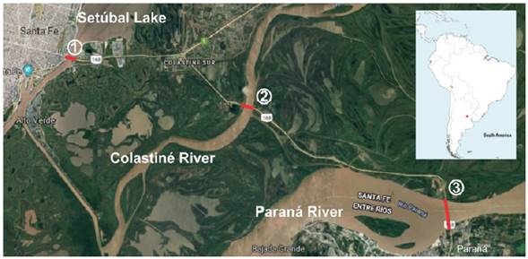
Source: Google Maps, https://www.google.com.ar/maps/@-31.6651185,-60.5796842,21348m/data=!3m1!1e3 Consulted: October 21st, 2019.
Figure 1 National Route 168 (Santa Fe-Entre Ríos, Argentina) and the Three Cases of Study. 1- "Nicasio V. Oroño" Bridge 2 - Colastiné Bridge 3- "Uranga Sylvestre Begnis" Subfluvial Tunnel
The hypothesis that guides the study assumes that infrastructures and their materiality have influenced the transformation of the territory that contains them, specifically the Santa Fe-Paraná metropolitan area (hereinafter called AMSFP)13 which population has surpassed one million inhabitants according to 2010 Census14. Have these infrastructures been decisive in shaping the area? If so, how? Have these transformations been politically intentional? In the analysis of the cases addressed, we intend to verify the transforming force of these infrastructures in the dynamics of the area of study, through the recognition of their constructive systems, their architectural aspects (if any) and their production conditions.
Crossing a Giant
The notion of territory encompasses beyond a physical dimension. The territory is rather a geographical space (therefore, a place of production and reproduction of social relations) intimately linked to the control exercised over it. From geography, Blanco explains that the concept of territory "...carries implicit notions of appropriation, exercise of dominance and control of a portion of the Earth's surface, but it also contains the ideas of belonging and projects that a society develops in a given space (and time)"15. It means that behind that exercise of power over a certain portion of land there is a more or less defined strategy, with means and ends. Sack16 calls this territoriality, understood as the way in which a society is organized in space to affect, influence and control resources and people. Taking into account these meanings of the concept of territory, it is interesting to analyze the territoriality exercised by the Argentine national state in the 1960s, in this case materialized through works of architecture and transport infrastructure.
In this period, territorial planning is closely linked to economic planning, therefore, it is understood in the sense of ordering the territorial nature of the capital circulation process. For Swyngedouw, the territory assumes a double function: on the one hand, as a production force, that is, as a vehicle for the generation of capital gains; on the other, as a social relationship, that is, with the purpose of ensuring the equitable distribution of these capital gains17. From this perspective, the territory is intimately related to the political and economic processes of a nation, and with its aspirations for social equity. In addition, as Harry S. Truman had mentioned in his speech, to achieve those aspirations, reaching levels of urbanization was one of the steps.
The portion of territory covered by the study is crossed by the Paraná River. This river is the second largest river in South America (after the Amazon). Its name, of Guaraní origin, means "relative of the sea", in relation to its large size. Its main channel and tributary branches were for a long time an obstacle to be saved every day to physically communicate the Argentine cities of Santa Fe (Santa Fe) and Paraná (Entre Ríos). Moreover, the entire Mesopotamian area of the country comprised by the provinces of Entre Ríos, Corrientes and Misiones was, for a long time, physically disconnected from the rest of the Argentine territory. Historian De Marco (h) indicates that the port system oriented to foreign trade "was one of the main reasons for the absence of a transversal corridor that joined the country with Mesopotamia"18. This was the case until the 1960s, when large transport infrastructure works were carried out to solve the historic separation caused by the presence of a large river.
Specifically, the cities of Santa Fe and Paraná maintain historical links, mainly for their potential commercial and political communication with the neighbouring country of Uruguay, but that connection was not always easy because the rising of the Paraná River often flooded those roads that were originally land. In the nineteenth century, the first positive attempt of relative continuity between the two cities was established19. This one consisted of a railway branch that connected the current bus terminal of Santa Fe with the port of Colastiné and from this point, connection was made on boats that transported goods and people to the port of Bajada Grande in Paraná. In March 1929, a raft service began operating under the Ministry of Public Works of the Nation. It transported cars while people crossed by boat. The transfer linked the ports of Paraná and Santa Fe, with a route that was modified several times until the inauguration of the "5 de Octubre" berth on Berduc Island in 1955, to fix the boarding site on the Santa Fe margin20. Meanwhile, in 1932, the National Highway Law was enacted, which meant great achievements for Santa Fe; Route 168 was given the condition of National Route and acquired its current composition: Santa Fe - La Guardia - "5 de Octubre" Berth (Subfluvial Tunnel) - junction provincial Route 12.
From its origins as a local filthy road to what it is today- a national highway- National Route 168 was subjected to many infrastructure works that were carried out over time, including transformations in the infrastructures themselves that were already built21. In this context, the three works that are addressed in the present paper were of utmost importance in defining the physiognomy of the corridor. In turn, each of such works, as well as the sum of all of them, implied a resounding change and modification in the daily traffic commuting between Paraná, Santa Fe and their surroundings besides helping shape the AMSFP. It has been defined by the existence of two main urban centers, a high degree of interrelation between them, a certain capacity of the area for self-management to assume important infrastructural undertakings and the advance in institutional and administrative articulations between different governmental jurisdictions, among others. The recognition of this category is supported by statistical and census information, besides the geographical notion of continuity which is hindered or almost impeded by the features of the territory: the presence of a large river and the linear connection on a strip of narrow width and fragile stability22.
The area of study features the presence of water as the protagonist since the Parana River crosses it through its middle section. This forms a landscape of streams and island areas with high biodiversity and a natural and cultural heritage associated with that wealth. It also has populations and heterogeneous dynamics, insufficient services and infrastructure in some cases, land use patterns that have not been planned regionally, as well as different degrees of awareness and preparation facing the vulnerability of water risk. For these populations, the presence of the river throughout history has meant a constant effort in the construction of infrastructures for the materialization of road connections and water defence works for protection against floods. This point is worth mentioning since it explains the approach this investigation pursues on road connection infrastructures. With regard to the process of historical conformation of the road network of the AMSFP we can recognize three great moments23:
In the first place, the 1930s, when the National Consolidation of Regional Roads in Argentina took place24 through the creation of the Dirección Nacional de Vialidad (hereinafter DNV) as an autonomous administration. At that moment, enumeration and paving of the sections of the busiest routes was being carried out. In second place, the 1960s and 1970s, when, within the framework of the development program, transportation and energy works were planned to supply the new provinces (former national territories25) and promote national industry. Finally, the 21st century, when enlargement works predominate, in line with the increase in traffic levels and the expansion of urbanizations. Urban expansion, which are characteristic of the late twentieth and early twenty-first century, begins to exert pressure for the definition of enlargement works that speed up the link between the central city and the peripheral cities.
This article is about the second historical period and it proposes the investigation of the constructive processes of three large infrastructures located on the path of the current National Route 168, which joins the cities of Santa Fe and Paraná.
Bridge over the Colastiné River (1957-1967 and 2009-2010)
The bridge works on the Colastiné River (which belong to the Paraná River system) constitutes the first communication infrastructure in the Mesopotamian region. Not only was this fact an important milestone in the physical connection of the provinces of Santa Fe and Entre Ríos, but it was also the first infrastructural achievement in the integration of this region into Argentine territory. The works, faced by the Compañía General de Construcciones, consist of a prestressed bridge with a total span of 550m and 8.30m of road width plus two sidewalks. Such bridge is made up of ten sections of 50m each that are supported by two headers and nine ovoid pillars. All of them have been sunk up to 23m below the riverbed. The board is made up of 50 pre-compressed, precast concrete beams weighing 10tn each (the sections comprise five beams each) that were built on site. It was unnecessary to use arch centerings since its placement was carried out by the use of metal beams. It is the first time that the Freyssinet license was used in the country for this type of construction and this allowed the assembly all the structural elements of the board on land and then move them and place them in their corresponding place, avoiding dangerous pile digging manoeuvres of shuttering chambers. In turn, this system permitted that each of the 125tn beams show a slenderness that "can be considered a boast of technique"26 since at that time the use of prefabricated beams was rather unusual. As for building materials, the bridge demanded 26,000m3 of concrete and 600tn of soft iron for its foundations, while the superstructure required 2.200m3 of concrete, 11tn of soft iron and 160tn of hard steel.
During its construction, it was necessary to overcome the difficulties of water sulphation that attacks and decomposes concrete, which could delay works. In addition, although the work of the bridge itself was completed in 1966, it took one more year to complete the access embankments that enabled its use. The expectation of inauguration was great because it is not difficult to imagine how life developed between the two main cities before the existence of such a work. Two stories from the local newspaper at that time bring us such an impression:
Su utilidad será incuestionada ya que permitirá eliminar el engorroso y lento cruce de esa vía de agua por la balsa a maroma, que actualmente no funciona por los daños experimentados a causa de la crecida en el atracadero de la Isla Berduc, lo que hace inútil el empleo del camino pavimentado que cruza la mencionada isla.27
... cuya valoración es menester repetir, pues sobradamente se sabe cuáles son las penurias que hay que afrontar para emprender un viaje que es físicamente tan corto como lo es a Paraná y que, sin embargo, en tan corto trayecto reúne tal cumulo de inconvenientes que realmente desalientan.28
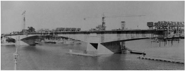
The route was long and consisted of different parts: raft, island, section of road, another raft. The bridge over the Colastiné River, which is an important work in itself, does not manage to manifest at a glance the impact that it meant for the territory, its geography and nature, everyday life and the citizens of both capitals. Traffic on National Route 168 (which crosses over the bridge) multiplied exponentially in the 21st century, not without fatal facts to its credit, and this demanded the modification of its appearance and use. When the National Route 168 was converted into a highway in 2010, the bridge was duplicated. Again, a novel constructive method was used in the country and in South America for a crossing of this scale: works were carried out by the system of successive launching of voussoirs, concreted in situ in a fixed prefabrication site (figure 2 and 3).
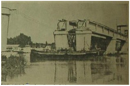
Source: El Litoral, February 25, 1965, http://www.santafe.gov.ar/hemerotecadigital/diario/27782/?page=4
Figure 2 Construction of the Bridge over the Colastiné River. Foundation of Support Cylinders
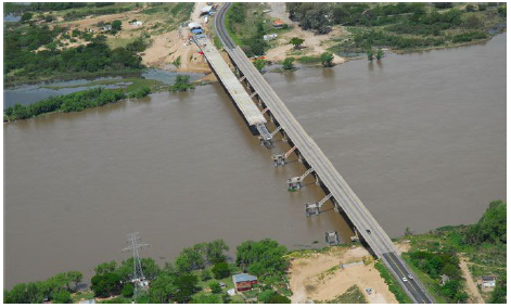
Source: Revista Vial, October 25, 2013, http://revistavial.com/innovador-metodo-constructivo-de-puentes-en-la-provincia-de-santa-fe/
Figure 3 Aerial View of the Original Bridge over the Colastiné River and Construction of the Second Bridge Using the Launching System
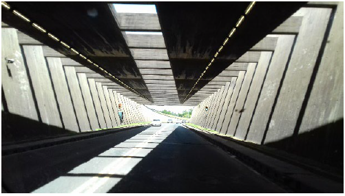
"Uranga-Sylvestre Begnis" Subfluvial Tunnel (1961-1969)
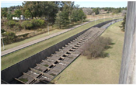
After long political negotiations, the governments of Entre Ríos and Santa Fe agreed on the construction of a subfluvial tunnel that crossed the Paraná River29, which represented a challenge of physical connection between the two provinces. The site of this tunnel crosses the river in its middle section joining the city of Paraná and the island Santa Cándida in Santa Fe. The tunnel itself is 2.7 km long. Two entrance headers are added. The constructive system chosen for this section was that of trenches, previously dug in the riverbed. The work is complemented with the in situ construction of the huge tubes (MON, 1956). The tunnel consists of 37 concrete tubes (built with boulder of the Uruguay River, Paraná river sand, iron from San Nicolás and San Martín cement manufactured in the capital of Entre Ríos). The tubes were constructed in batches of four in a dry dock built on the left bank (Paraná city side). Each of them took three months to be built. Once the tube was finished (with its ends sealed by removable metal bulkheads) the dam was flooded until the tube began to float and could be towed, submerged and, with the help of divers, placed in the trench. Among the specific instruments that were used for their construction30, the Teler concrete vibrating equipment stands out among the others since it allowed the sand to be compacted on the tubes and the union of the joints.
Architect Mario Roberto Álvarez and associates projected the architectural program, which is repeated on both sides of the river. It counts with buildings for administration and toll, buildings for energy plants, and landscaping. A single large covering made of concrete and large spans, give the impression of an "outstanding, magnificent site"31. The water tank, which is a vertical tube, contrasts with the horizontality of the large cover. The coffered ceiling and the columns are made of exposed concrete showing a contrast with the toll offices that were originally made of aluminium. This studio also projected the headers of the tunnel: they have access ramps and ventilation chimneys. The access ramp to the tunnel is designed as an "accommodation zone" or "adaptation" which consists of a series of beams placed on the roof whose distance shortens as it progresses "so that the perception and feeling of confinement for drivers of vehicles turns out to be smooth and gradual"32. At the same time, the sides of the Paraná header are raised, in order to expand the view. This does not show on the Santa Fe header, whose sides are straight. The components that stand out most within the set are the ventilation towers: two on each side of the tunnel. These are service elements that exchange clean and stale air from inside the tunnel and which, nevertheless, have been treated as if they were sculptures. The union gallery of these towers with the set and the perimeter wall of the annex have been treated as a horizontal band coated in turquoise ceramics.
Local people feel very proud of their tunnel. In the first place, it has given value to their daily lives, but then, it gained a renewed recognition in terms of its aesthetics, since, among other things, it has been used as cinematographic settings and photographic exhibitions (figures 4, 5 and 6).
Source: Estudio MRA+A (Mario Roberto Álvarez & Associates), Buenos Aires, Argentina, http://mraya.com.ar/public/img/subidas/originales/a595ad301b5f6012df8e33c169e892f9.jpg
Figure 4 Inauguration Day. Subfluvial Tunnel
Source: Photo taken by Camila Costa, 2017.
Figure 5 Combination of Lights and Shadows Inside the Subfluvial Tunnel
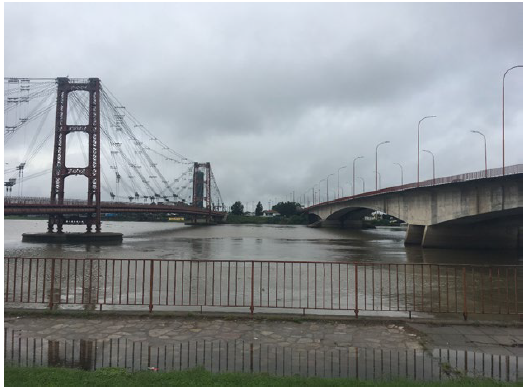
"Gobernador Nicasio V. Oroño" Bridge and Viaduct (1968-1971)
Negotiations for the construction of an infrastructure that complements the historic Santa Fe bridge "Ingeniero Marcial Candioti" (popularly called "Colgante" since it is a suspension bridge) date from the early 60s. From the Department of Access to Large Cities (dependent entity of DVN) a comprehensive intervention was thought for the city of Santa Fe. This involved, among other things, its entrance, its ring road, its main avenues and other sections of light and heavy vehicular route. A bridge and a viaduct were the answers to the first aspect33. The Oroño Bridge and viaduct is the third large-scale engineering work in the corridor of National Route 168, and similarly to the tunnel, which ends at the entrance of Paraná city, the bridge was built as the gateway of Santa Fe city. The viaduct was mainly constructed to absorb the traffic flow that was exceeding the capacity of the "Colgante" Bridge (located 100m upstream on the Setúbal Lake and built in 1925) and predicting its structural collapse by the action of the water on its bases during flood periods.
The work included viaducts at both ends, accesses and asphalt paving. Later on, defences were added on Santa Fe side. The bridge has a span of 300m and it is divided into three sections, that is to say, that it has two supports in the river. It also bears sidewalks and two roads, each 7.5m wide, separated by a stone division. The structure is made up of two main beams of reinforced concrete, of variable height, prestressed box type, built in successive sections by voussoirs measuring 3.11m. The bases are supported by 22 piles sunk between 15m and 25m below the scour level and with a diameter of 1.5m: so far, the largest in the country. As in the case of the bridge over the Colastiné, the Freyssinet system was also used here, but with the exceptional variant of using 24 0 7 cables that bifurcate before reaching the anchor, allowing a better use of the concrete, which was heated with steam to absorb the climatic variations in the hardening stages. The proximity of the viaducts to the urban area was taken into account, therefore, the one on the Santa Fe side shows curved branches that cross landscaping areas. Both ends are supported by Franki piles of variable length and 70 cm diameters. A system called "lost formwork system" was used for building piles next to the coast. The whole work played a fundamental role in the unusual flood of the Paraná River in 1982 since one of the consequences of this phenomenon was the destruction of one of the bases of the "Colgante" Bridge (made in a semi-rigid iron structure) rendering it useless and leaving the Oroño Bridge as the exclusive terrestrial communication (figures 7 and 8).
From Technical Innovation to Transformation of the Territory
The three infrastructures presented in this paper were carried out following the guidelines of the developmental model, and built with technologies based on the use of concrete. They are located in the alluvial plain that divides a metropolitan binuclear area and that is modified by the dynamics of the water cycle. The interconnection of this area in terms of activities and exchanges originates a high degree of mobility through the corridor of National Route 168. What was a journey of several stops and long queues during the first half of the twentieth century, today is a 30-minute experience. Before the existence of large infrastructures on the corridor, crossing from Santa Fe to Paraná and vice versa meant, in its different stages, combining different means of transport to cover a distance of 30 km. It involved boarding a train, driving to a berth, travelling by boat for a while and then by raft, among other variants.
Today, that combination of transfers is simplified, times are shortened, and car traffic has increased significantly. Of the 1420 vehicles commuting daily in 1968, and 3640 vehicles registered in 1970 with the tunnel already in full use34, the Entity of the Subfluvial Tunnel nowadays has records of 11 000 vehicles that cross the tunnel on a daily basis, and therefore ride along Route 168, at least up to La Guardia. These three infrastructures were a milestone in the constitution of the corridor. Although this process was consolidated in different stages and by different factors, the role of concrete as the predominant material in their construction is noteworthy. When combined with steel, concrete creates a technology that achieves unthinkable works in comparison with any other material. In a way, concrete gives human beings the "illusion" of dominating nature, which in this case is the insurmountable obstacle that for years the large Paraná River floodplain represented.
As Forty points out35: concrete presents us, in this case, a double reading of its role in the construction of the medium. On the one hand, it introduces the urban in nature, allowing hundreds of cars to cross a large river with its tributaries and be part of an extraordinary experience that would otherwise be difficult to achieve. The large spans needed to overcome the obstacle of the water are only possible with constructive technologies (trenches, launched or voussoirs) that have concrete as "the protagonist". On the other hand, the material, at the same time natural and artificial, creates the landscape, characterizing the whole journey in a combination of nature and infrastructures. Not only is concrete the condition to have the possibility to experience that territory, but also, a constituent part of it. Whether the result is aesthetic or not matters little, because everyday users have become accustomed to this type of infrastructures and facilities (transport) because they are essential, in the cases studied, for the physical connection of the locations, no matter how they are inserted into the landscape.
The three works were completed in a very short period of time (1967-1969-1971), and they were all carried out in the framework of developmental policies. During this period the new materials (although not all) began to be available nationwide. This, besides the new theoretical tendencies in architecture (systems theory, brutalism, megastructures, megaforms) and the outstanding role of the engineers (some of them military) made it possible for concrete to become people friendly. With these factors in mind, it is possible to comprehend a technological conception around the great spans and the aesthetics of concrete, understood as an acceptance of values and representations linked to certain technologies. This was already at stake in the discipline of architecture long before, but it appeared into the view of the passers-by from this moment onwards. The automobile boom and driving, understood as a civic activity and no longer as a technical capacity36, allowed the usual ride both in architectural works at an urban scale, and infrastructure at a territorial scale.
Bruno Latour37 proposes a model of thought where human action and technical action are difficult to distinguish. The author exposes it to study sociological phenomena, but in this case, when addressing the circumstances of production and development of infrastructure works (artifacts), his point of view also becomes relevant. In this sense, although much interest for bridges and tunnels lies on their technical audacity, when interpreting them as elements of the landscape, they must be understood in the social context of technology: "And how new objects are interpreted and integrated into the interweaving of social life"38. That is to say, that their assessment is, at the same time, an admiration for the achievements and an acknowledgment for the everyday use that is made of them. They are highway bridges that privilege the automobile, at the expense of the railroad and other means of transport. The raft that crossed from Paraná to Berduc Island continued to operate until the 21st century, and it served for the transportation of trucks with fuel cargos. However, after the construction of a new bridge (2003) between the town of Victoria (Entre Ríos) and Rosario (Santa Fe), in the Lower Paraná River, the raft service was completely left aside, leaving the route to motor transport exclusively.
The determination that these works have had as artifacts and currently have on the development of the AMSFP is valuable if they are both analyzed as a whole and individually, as Latour points out. Each one contributed as a significant advance and recognition from the public with each inauguration and this last can be confirmed in the numerous journalistic articles that expectantly record the progress of each work until its concretion39. Nevertheless, technological determinism (according to Smith's terms40) should not be reduced to the use of a particular technology in this case. In fact, it should not be reduced to concrete technology in particular. Because people have selected it within a set of other technologies, guided by a policy and time -consciousness that made that material, and in those conditions, predominant. Technological determinism applied to large infrastructures can and must be understood considering two fundamental aspects. On the one hand, taking into account the production context of the works, in these cases linked to the promotion of the national technological identity that was manifested in the world41. This condition implied, on the part of the State and the society itself, the admiration for the great works of engineering, the confidence in State technicians and the admiration for the achievements reached that represented progress. In this sense, "large infrastructures were the most complete crystallizations of the State's will to build and make a national territory visible"42.
On the other, it implied the recognition of the level of appropriation and valuation of large infrastructures by their everyday use and by the experiences that make them possible. As Nye points out: "to understand them in the social interweaving", that is, not in its symbolic power but in its practical power. This condition could explain why unlike other large-scale ventures43, these works were not the object of socio-environmental protests, and instead were widely accepted by the public. The three works as a whole were invaluable for the growth of the dynamics in the area and for the development of the territory. In its recognition we cannot ignore that they were conceived in a specific period of Argentinian political and economic history, following the guidelines of constructive systems based on the use of concrete as a predominant material, and under the eyes of a society that looked forward to its concretion to improve their daily performance.

