


 English (pdf)
 Article in xml format
 Article references
 Send this article by e-mail
 Cited by SciELO
  Cited by Google
  Similars in
SciELO
Similars in
SciELO  Similars in Google
 Permalink
INTRODUCTION
Roads may represent an important factor of economic and social development for a region 1,2. However, their presence may result in strong environmental impact, such as the removal of natural vegetation to their construction (3, isolation of the natural populations and loss of animals by roadkill 4.
It is estimated about one million of vertebrates annually killed by vehicles on roads in the United States 4. In Brazil, roadkill estimations are still scarce 5.
Therefore, fauna roadkill is recognized as the main cause of vertebrate mortality, surpassing even the hunting 6. Some studies also suggest that the presence of roads can represent a major threat to wildlife when near to conservation areas due to the high abundance of species and individuals 7.
The reduction of natural populations by roadkill increases their risk of extinction 2. Estimating and monitoring this impact over the fauna is essential to propose mitigation actions 8. In this context, the molecular analysis is a powerful tool to correct species identification 9 and it could be used whenever morphological species identification is difficult.
In this work we surveyed roadkill vertebrates around a Cerrado protected area in Southeastern Brazil and identified roadkill hotspots, which could be used in mitigation plans in order to reduce the impact over the local fauna.
MATERIAL AND METHODS
Study site . Roadkills in two municipal wide-lane roads (Domingos Innocentini and Ayrton Senna roads) around an important area for Cerrado biome conservation (Itirapina city, São Paulo, Brazil) were surveyed. This area is one of the few remaining protected areas of this biome at São Paulo State where are located the Itirapina Ecological Station (IEcS) and the Itirapina Experimental Station (IES), surrounded by a buffer area comprised by Cerrado and riparian vegetation. The IEcS (22º11'S, 47º51'W) covers 2300 ha with many threatened species, such as, maned wolf (Chrysocyon brachyurus), rhea (Rhea americana) and cougar (Puma concolor) 10. The IES (22º15'S, 47º45'W) encompasses 3212 ha in which about 2000 ha are used for scientific research and cultivation of exotic vegetation (Pinus sp. and Eucalyptus sp.).
Data collection. The sampling sites were chosen considering the proximity to the protected area of Cerrado in Itirapina. We surveyed 12 km (seven km inside the protected area and five km in the buffer area) at the Ayrton Senna road and four km around the limits of the protected area at Domingos Innocentini road.
The roads were checked twice everyday during five days/week from May 2012 to August 2013. We registered the local of roadkills with a GPS, photographed the animals and registered biometric and morphologic data (paw size, tail size, weight) and sex. We also collected samples of tissue (muscle, skin or hair) in order to confirm molecularly the species identification and create of a genetic database for future molecular analyses. Threat status of species was categorized following the list of threatened fauna of São Paulo State 10.
Molecular species identification. DNA was extracted from tissue samples using fenol-cloroformio protocol 11. The DNA integrity was verified using 1% (w/v) agarose gel and the quantification was conducted with BioPhotometer (Eppendorf Corporation(r)). We used 16S 12 and COI 13 universal primers to molecular species identification. The PCR (polymerase chain reaction) protocol was similar for both primer sets as it follows: 1X buffer tris-KCl 10X (Tris-HCl 200 mM pH 8.4 and KCl 500 mM), 4 mM MgCl2, 0.25 mM dNTPs, 0.3 pmol of each primer, 1 U Taq DNA Polymerase Platinum (Invitrogen) and 50 ng of DNA template for a final volume of 25 µl. The DNA amplifications were carried out in an Applied Biosystems Veriti(r) Thermal Cycler under the following conditions: 94ºC for 4 min, 35 cycles at 94ºC for 45 s, 50-51ºC for 45 s, 72ºC for 45 s and a final extension at 72 ºC for 10 min.
PCR products sequencing was performed in an automated sequencer (ABI3730XL, Applied Biosystems) by Macrogen, Inc., in South Korea (www.macrogen.com). The nucleotide sequences were compared to databases from NCBI (National Center for Biotechnology Information) and BOLD (Barcode of Life Data Systems) to the species identification.
Data analyzes. The frequency of roadkill was calculated dividing the number of killed animals by the number of kilometers covered during the whole study period.
The roadkills were plotted over the local road map using Siriema software (Spatial Evaluation of Road Morality Software) 14 to identify the hotspots of occurrences. We used the Ripley's K statistics 15 to evaluate the non-random distribution of roadkills. Although the road linearization causes loss of dimensionality, with this transformation the formation of false clusters at the curves was prevented 14.
Influence of landscape characteristics on the roadkill hotspots was also evaluated. A land cover map of the studied area was constructed by using satellite images from Google Earth 16 and the Quantum GIS program 17 with five meters final resolution. The distance between a hotspot and its nearest land cover was calculated. Land cover was classified as natural vegetation (including Cerrado and riparian vegetation), river, lakes, sugar cane, silviculture, pastures and urbanized areas. The association between hotspot and land cover was tested by ANOVA and significant association was evaluated by Tukey test, after data log transformation.
Linear regression between the monthly average temperature obtained from the registers of Itirapina Ecological Station (IEcS) and the number of roadkills per month, with log transformed data to fit the parametric tests requirements was also performed to investigate whether there are influence of the environmental temperature on number of roadkills.
RESULTS
We registered 31 roadkilled animals of 21 different species in 16 months (Table 1). From the total of species, Leopardus pardalis (vulnerable), Cuniculus paca (near threatened) and Chrysocyon brachyurus (vulnerable) were stated according to the list of threatened fauna of São Paulo State 10.
Table 1 Species and number of roadkilled individuals.
| Species | Common Name | Individuals | |
|---|---|---|---|
| Mammal | |||
| Leopardus pardalis | Ocelot | 1 | |
| Didelphis albiventris | Opossum | 1 | |
| Lepus europaeus | European hare | 1 | |
| Cuniculus paca | Spotted paca | 2 | |
| Coendou prehensilis* | Porcupine | 2 | |
| Chrysocyon brachyurus | Maned wolf | 2 | |
| Myocastor coypus | River rat | 1 | |
| Procyon cancrivorus | Raccon | 1 | |
| Dasypus novemcinctus | Nine-banded armadillo | 2 | |
| Sylvilagus brasiliensis | Tapeti | 2 | |
| Mazama gouazoubira | Brown brocket | 1 | |
| Cerdocyon thous* | Crab-eating fox | 1 | |
| Reptile | |||
| Ameiva ameiva | Giant ameiva | 1 | |
| Tupinambis merianae | Black-and-white tegu | 3 | |
| Crotalus durissus | Cascabel rattlesnake | 3 | |
| Boa constrictor* | Boa constrictor | 1 | |
| Sibynomorphus mikanii | Neuwied's tree Snake | 1 | |
| Philodryas olfersii* | South American green racer | 1 | |
| Erythrolamprus aesculapii* | False coral | 2 | |
| Bird | |||
| Cariama cristata | Red-legged seriema | 1 | |
| Polyborus plancus | Caracara | 1 | |
| Total of species | 22 | ||
| Total of individuals | 31 | ||
* Species that could not be confirmed molecularly
The mortality rate was 1.46 animals/km/year and three significant clusters of roadkill were detected in 0-1 km, 3-3.5 km and 13-14 km along the 16 km sampled (Figure. 1). In one of these points (0-1 km) for example, we registered seven roadkilled animals, which represents 22.6% of total records. Positive association between the presence of natural vegetation and roadkill hotspots (p=0.009) was detected.
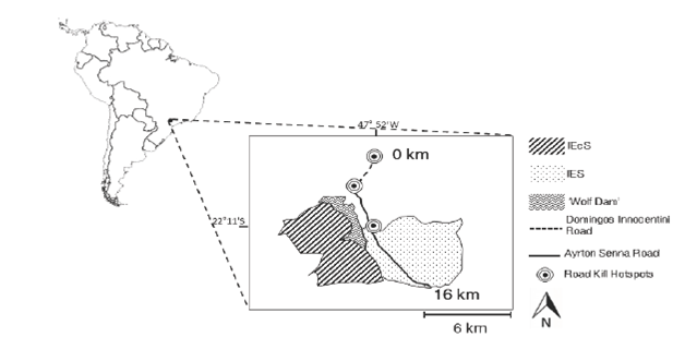
Figure 1. Geographical location and detail of roadkill hotspots. IEcS (Itirapina Ecological Station); IES (Itirapina Experimental Station).
The number of roadkills was higher according to the environmental temperature increasing (F1.14 = 8.39, R2 = 0.375, p = 0.012). The months with higher mean temperature (October and November 2012, with 26.1ºC and 25.1ºC, respectively) presented eight roadkilled animals, which represent 25.8% of total roadkilling.
DISCUSSION
The local fauna inhabiting the area here studied is over a strong roadkill pressure. The mortality rate observed (1.46 animals/km/year) was much higher than reported by Da Cunha et al. 18 in an unprotected area of Cerrado (0.014 animals/km/year), suggesting that road impact is more drastic around protected area where fauna abundance is expectedly higher. This observed difference in roadkill intensity makes important to survey and elaborate specific mitigation actions for each target location.
A large number of records and species were here detected, including species with great ecological importance, such as the maned wolf and the ocelot. Since these species are top predators, they are vital in maintaining the equilibrium of other species populations and the loss of individuals can result in ecological consequences to the local fauna, such as disequilibrium on herbivorous density and consequently on plant community 19. It is imperative to highlight that the number of roadkilled animals may be much higher than reported here because some animals may not be detected or carcass could possibly be removed due to weather conditions, for example.
Mammal and reptile species represented 54.8% and 38.7%, respectively, of the roadkilled animals. Only five species could not be confirmed by molecular analysis probably due to bad conservation of tissue samples, which impaired the DNA amplification in PCR, although these seven individuals could be morphologically identified. In contrast, the success in identifying most of samples demonstrated the great potential of the DNA analysis, mainly for those specimens hard to identify morphologically because of their level of degradation or when the taxonomic group needs a specialist for correct identification.
Roadkill number was higher during the warmer months and such outcome was mainly influenced by Tupinambis merianae roadkills, probably due to the animal movement for reproduction often associated to the warmer temperatures season 20. Then, strategies to facilitate or avoid road crossing by animals should be more effective if they take into account the known reproductive periods that turns the animals more vulnerable to the roadkills.
The three detected roadkill hotspots were associated to the natural vegetation presence, which suggests that they are important points of animal crossing. At the 0-1 km hotspot, the main local of roadkills, natural remnant of Cerrado on both sides of the road is predominant. At the others two hotspots, the road intersects small streams with riparian vegetation. It is suggested that more roadkills near to natural vegetation than near to sugar cane plantations and pasture, is associated to preferential animal moving through this type of land cover. Open areas usually offer lesser resources for the animals, besides risk to be exposed is increased. Similar results were also found by Bueno et al 21 showing strong correlation between landscape characteristics on capybara (Hydrochoerus hydrochaeris) roadkill on other Brazilian highway.
Such studies demonstrate the importance of monitoring wildlife in linear infrastructure, especially around protected areas, since roadkill may represent a strong threat to the local fauna. The roadkill hotspots determination is the first step to reduce these impacts on wildlife. A number of strategies can be efficient to reduce or prevent animal roadkills: Wildlife crossing as underpass tunnels, overpasses with fences to drive the animals as well as, velocity control sensor and warning traffic signs at these hotspots, contributing to reduce deaths on the road.
In sum, our work provides a strong evidence of the most critical points where the mitigation strategies should be implemented immediately to reduce the roadkills in the studied area. This study highlights the importance of detecting the main points of roadkill and the more affected species or taxonomic groups, supporting the elaboration of effective actions that can improve the fauna conservation.

