


Services on Demand
Journal
Article
 English (pdf)
 Article in xml format
 Article references
 Send this article by e-mail
Indicators
-
 Cited by SciELO
 -
 Access statistics
Related links
-
 Cited by Google
 -
 Similars in
SciELO
Similars in
SciELO -
 Similars in Google
Share

 Permalink
Cuadernos de Desarrollo Rural
Print version ISSN 0122-1450
Cuad. Desarro. Rural vol.10 no.spe70 Bogotá Jan. 2013
Irrigated Family Farming Panorama in the Latin-American Highlands*
Panorama de la agricultura familiar irrigada en las tierras altas de América Latina
Tour d'horizon de l'agriculture familiale de l'irrigation sur les zones montagneuses d'Amérique Latine
Alvaro-Martín Gutiérrez-Malaxechebarría**
Simon Prime***
Christophe Révillion****
*This article was supported by the following research projects : "Impacto económico del riego informal en los sistemas de producción agropecuarios de ladera de la región Andina Colombiana", financed by the Pontificia Universidad Javeriana's academic vice-rectory and research projects that were partly developed through the projects ECOS - Nord n°M08H01 « Transformations territoriales et irrigation paysanne dans les vallées de Puebla (Mexique) » (2009-2011) and ECOS - Nord n°C0<)H02: « Les relations entre systèmes de production et écosystèmes dans les Andes Colombiennes », 2009-2011. We thank Jaime Forero Alvarez, Alexandra Angeliaume-Des Camps and Jean Christian Tulet, who reviewed and commented this work. Special thanks to Sonia Patricia Hernández Ocampo, who translated it into English.
**Doctorate candidate in Estudios Ambientales y Rurales at Pontificia Universidad Javeriana, Bogota, Colombia. E-mail address: malaxechebarria@yahoo.com
***He started this study while being a student of the Doctorat de Géographie GEODE, University Toulouse II- Mirail, France. E-mail address: simon.prime@inbox.com
****Spatial Information engineer (Ingénieur spatial), UMR Espace-Dev, Institut de Recherche pour le Développement (IRD), Montpellier, France. E-mail address: christophe.revillion@ird.fr
Recibido - Submitted - Reçu: 2012-06-01 • Aceptado - Accepted - Accepté: 2012-06-02 • Evaluado - Evaluated - Évalué: 2012-08-10 • Publicado - Published - Publié: 2012-03-30
Cómo citar este artículo
Gutiérrez-Malaxechebarría, A. M., Prime, S., & Révillion, C. (2013). Irrigated Family Farming Panorama in the Latin-American Highlands. Cuadernos de Desarrollo Rural, 10 (70), 93-114.
Abstract
Although there are statistics and general cartography on irrigation systems in Latin America, this information does not permit to identify the irrigated family farming zones located in the highland areas. In this article we locate and quantify those zones through the use of cartographic methods that helped to identify the zones that meet three requirements: 1) they are irrigated areas; 2) they are located in zones above 1000 m; 3) Their rural population density is higher than 50 inhabitants per km2. The results confirm a wide presence of this type of systems in all Latin-American sub-regions. Nevertheless, due to the restrictions of quality and updating of the information from the available sources, the results given in the present document must be taken as a guideline.
Keywords author: Irrigation, family farming, highlands, cartography, Latin America.
Keywords plus: Irrigation, family farms, private plot agriculture, agricultural mapping.
Resumen
Si bien existen estadísticas y cartografía general sobre los sistemas de riego en Latinoamérica, esta información no permite identificar las zonas de agricultura familiar irrigada localizada en zonas altas. En este artículo ubicamos y contabilizamos dichas zonas mediante la utilización de metodologías cartográficas que permitieron aislar las zonas que cumplen tres requisitos: 1) son áreas irrigadas, 2) están ubicadas por encima de los 1000 m. y 3) su densidad poblacional rural es superior a 50 hab/km2. Los resultados confirman la amplia presencia de este tipo de sistemas en todas las subregiones de América Latina. Sin embargo, debido a las restricciones de calidad y actualización de la información de base, los resultados presentados deben tomarse a nivel orientativo.
Palabras clave autores: Irrigación, agricultura familiar, tierras altas, cartografía, Latinoamérica.
Palabras clave descriptores: Riego, granjas familiares, parcelas agrícolas privadas, cartografía en agricultura.
Résumé
Bien qu'il existe des statistiques et cartographie générale sur les systèmes d'irrigation de l'Amérique latine, il n'est pas possible de distinguer les zones d'agriculture familiale irriguée situées en altitude. Dans cet article nous localisons et quantifions ces zones en utilisant des méthodologies de cartographie qui permettent d'isoler ce type de zones. Les critères retenus pour la sélection de ces zones sont : 1) la présence d'irrigation; 2) une densité de population rurale dépassant 50 habitants/km2; 3) une altitude supérieure à 1000m. Les résultats obtenus confirment une présence remarquable de ce type de production à travers du continent. Toutefois, en raison du manque de précision de certaines sources données, les résultats présentés sont à titre informatif.
Mots-clés auteur: L'irrigation, l'agriculture familiale, des hauts plateaux, la cartographie, l'Amérique latine.
Mots-clés descripteur: Irrigation, fermes familiales, privés des parcelles agricoles, cartographie agriculture.
Introduction
The Latin-American family farming production systems, much of which uses irrigation, contribute significantly to the regional agricultural production. Although family farming takes place in very varied contexts, most of these production systems are traditionally located in the highland zones, where the climate variety and incorporation of green revolution practices, including irrigation, allow a wide and diverse agricultural production.
Latin America has a long irrigated agriculture history, which dates back to pre-Hispanic times, especially in Mexico, El Salvador, Guatemala and Peru. Although it is possible to find working pre-Hispanic systems, especially among the family producers, the current configuration reflects agricultural development processes encouraged within the 20th century. Irrigated agriculture is not widely developed, since the irrigation infrastructure has been developed only in a 17 per cent of the irrigation-suitable area, which is estimated to be 77.8 million ha (FAO, 2000).
Information about agricultural and irrigated areas is usually not updated, and its level of detail does not allow differentiation based on location or type of producer.
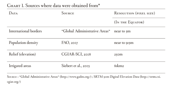
FAO, especially its tool AQJASTAT1, Siebert, Doll, & Feick (2007) and Thenkabail et al.(2009) are the main sources of statistical and cartographic data on irrigation. The two first are used in this paper. In order to identify the highland family farming irrigation systems areas, the information about the irrigated areas was cross-referenced with topographic information available in CGIAR-SCI (2008)2 and rural density data from Geonetwork, one of FAO's (2007) tools3.
1. Irrigation in Latin America
Figure 1 shows the regional distribution of the irrigated areas and their evolution for about half a century (1961-1997). Additionally, there has been a small growth of the irrigated areas, especially the ones originated by the state, since the 90's, few changes also occurred between 1997 and 2012.
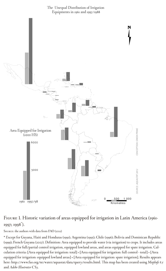
The distribution of the irrigated areas is far from being homogeneous; more than 66 per cent of Latin-American irrigation is located in four countries: Argentina, Brazil, Mexico and Peru. Nevertheless, when pondering the current importance of areas equipped for irrigation with respect to each country's cultivated surfaces, it is possible to see that the countries with relatively high levels of irrigation infrastructure, such as Brazil, Mexico or Argentina, have that infrastructure on a very reduced portion of their agricultural surface.
In order to understand the irrigation dynamics, it is necessary to distinguish between the areas that have irrigation infrastructure and the ones that are actually irrigated, since not all the equipped areas are working. In Latin America, only 80% of the irrigation infrastructure is in use (FAO, 2012) and that proportion varies from one country to another, as it is shown in figure 2.
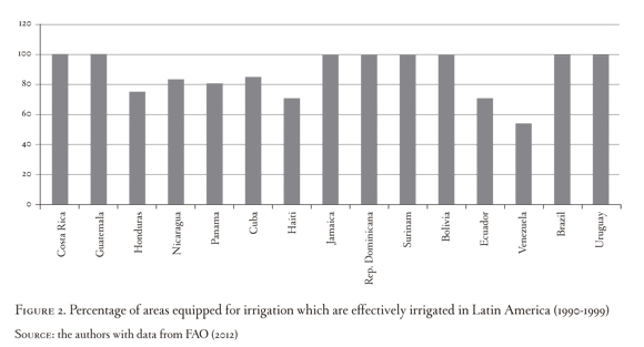
When adjusting the areas equipped for irrigation to the working areas, allows revising statiscal data. According to Siebert et al. (2005), this gap is due to different causes: :"For most of the countries, these statistics refer to the area equipped for irrigation. Due to several reasons (e.g. crop rotation, water shortages, damage of infrastructure) the area actually irrigated may be significantly lower than the area equipped for irrigation" Another factor that makes us be cautious before data exactness and their interpretation is that, according to each country, there are different methods to count the irrigated areas. For instance, certain zones belonging to public irrigation districts in Colombia, are zones where dry agriculture is developed, but the whole of these districts is counted as irrigated area (FAO, 2010)
1.1. Origin and management of irrigated zones
Although a great part of the big irrigation projects has been financed with state resources through irrigation districts, the private sector also plays an important role in irrigation systems development. That role is so important that approximately two thirds of the irrigated surfaces are private (Maldonado Rojas, 2000). This pattern, which is common to almost all Latin American countries, has clear exceptions, such as Peru and Mexico, where the relation is inverted. In these countries about 70 per cent of the irrigated area corresponds to state or public systems. This difference is basically due to land and associated infrastructure redistribution as a result of the Mexican revolution and the Peruvian agrarian reform.
Medium or large irrigation systems are usually co-managed by the state and the communities, and are characterized by some combination of public and common property regimes. Small or communal systems are mainly managed by the communities, which limits the role of the state, in most of the cases, to providing water flow to the community, and, eventually, resolving conflicts.
Within this context, since the 70's, self-management schemes have been encouraged inside the neoliberal policies logic, whose objective is to reduce the state costs and strenghten the appropriation processes by means of tranferring the public irrigation systems to the users. In countries like Chile, this process ended several years ago. In other cases, such as Peru or Mexico, this process is advanced. In Ecuador, Colombia and Guatemala, it is in progress. In Venezuela, Brazil and Panama, it has just begun, while it is under study in Costa Rica, El Salvador, Guyana, Jamaica and Dominican Republic (FAO, 2010).
Such processes have been widely discussed since the transfer of irrigation systems to users have not had substantial effects on the operations' performance, maintenance or the irrigated lands' agricultural and economic productivity. This situation affects the sustainability of those "inspired-by-the-state" systems suddenly given to private and communal users. Additionally, not always poor rural communities can finance the investments needed to build or operate the irrigation systems4 (Smith, 2002).
As a result of such diversity of processes, water for irrigation management systems and the regulations used are extremely different. This great variety results what some authors like (Boelens, 2009a; Cremers, Ooijevaar, & Boelens, 2005; De Vos, Boelens, & Bustamante, 2006; World Water Assessment Programme, 2009; von Benda-Beckmann, von Benda-Beckmann, & Spiertz, 1998) define as legal pluralism. About this issue (Boelens, 2009b) says that "analyzing and untangling the whole in particular contexts show that what seems to be an incomprehensible, unstable and irrational disorder unproper for governing the highly conflictive environment of water control, can be characterized as an organized complexity in the practice."5
1.2. Irrigated family farming in Latin America
The large scale of irrigation systems are generally located in low zones where most of the agro-industrial systems are developed, while the small scale and highland ones mainly serve family farming systems6. However, it is possible to observe both types of agriculture in every region.
Such sectorization is described by Linck (2006) for the Mexican case, and it is more evident for the countries located in the central and northern Andes, where most of the highland irrigation systems are found: in Colombia, only 4% of the formally irrigated total area is located in the highlands (data obtained through interviews to officials at INCODER). In Ecuador, it is 14% (Maldonado Rojas, 2000) and 20 per cent in Peru (Palerm-Viqueira, 2010). These data will be re-estimated in this article.
According to Forero Álvarez et al. (2011), most family farmers in each of these countries are located in the Andean zone. This implies that irrigation has been developed in a geographically unequal way, and its expansion has been marginal in the highland and family farming zones.
Neither the statistics nor the cartography that exists, allows us to distinguish family farming from other types of agriculture with accuracy. For this reason, it is necessary to observe the national dynamics7. Available data do not differentiate between highland and lowland irrigated agriculture.
Family farming in Latin America traditionally has had great importance in the production of fresh products and internal supply. It is estimated that by 1990, 85.5 per cent of the Latin-American agricultural units could be considered as family units (Chiriboga, 1999). Nevertheless, according to the same author, these production units corresponded to only 12.2 per cent of the region's agricultural area, which showed a great inequity in land property and, probably, in the kinds of crops those lands were used for8.
Although family farming is understood as that which uses mainly family labor, it is almost impossible to establish the boundary which indicates when a system is classified as family or capitalist. Therefore, the family farming characteristics will depend on several factors. A common strategy is to define the family production systems based on the farm size, which is arguable. FAO (2010) establishes that the family agriculture systems median surface varies according to each country: 3 ha in Colombia, 6 ha in Mexico, 23 ha in Chile and 26 ha in Brazil. Carmagnani (2008), who used information from national agricultural censuses, offers another classification to define the family farms size in five Latin-American countries: in Brazil, family farms are those smaller than 50 ha9. In Uruguay, these farms size fluctuates between 6.7 and 71.1 ha. In Buenos Aires province in Argentina, the average size for family farms is 149 ha, in Nicaragua, it is between 3.5 and 14 ha, and in Mexico, it is between 5 and 1o ha.
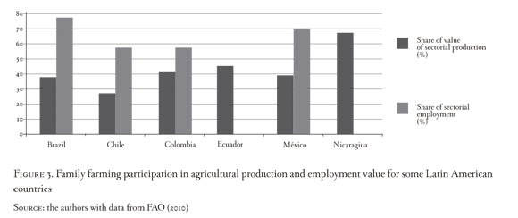
Despite the absence of universal statistics concerning family farming, FAO & BID (2007) claim that family farms in Latin America contribute greatly to the national agricultural GDP (PIB for its acronym in Spanish), as well as make a considerable contribution to generating rural employment (See Figure 3). Unfortunately, no data on agricultural employment in Ecuador and Nicaragua were found.
The quick expansion of strong added-value product markets, particularly horticulture, a small scale cattle-raising, fish farming and dairy products, offer an opportunity to diversify the agricultural systems and develop a small competitive agriculture with intensive use of hand labor (World Bank, 2007) and water for irrigation. In this sense, permanent access to water for irrigation is a key factor to stabilize and increase family farmers' incomes (Leiva & Skees, 2008). Van Der Zee, Fajardo Reina, & Holtslag (2002) found that, in Nicaragua, safe water access can increase family farming systems' incomes between 35 and 155 per cent, depending on the farm size; Jauregui et al (2005), found that such increase reached 236 per cent in Bolivia.
The environmental contexts of Latin-American family farming vary. National statistics do not differentiate family irrigation from agribusiness farming irrigation, nor do they differentiate lowland zones from highland zones. In Latin America there is highland or mountain irrigated family farming, where the slopes allow transporting water easily by using gravity force, which avoids pumping costs.
According to Zimmerer (2010), in the Andean case, the presence of irrigated family farming is especially visible in lands higher than 1000 m; this can be extrapolated to the rest of the mountainous zones in Latin America. The altitude of 1,000 meters is what we will use as the demarcation of the highlands from the lowlands.
The presence of mountain irrigated family farming, dedicated to strong added-value crops, can depend on multiple factors. These include the presence of transport infrastructure, the closeness to consumption or commercialization centers, and climate favorability provided by the altitudinal variation, providing cooler temperatures than in the lowlands. This climate offers the physical and sanitary conditions which allow vegetables and other "fragile" products to be cultivated all year long.
Mountain family farming is very sensitive to climate changes, as they are located in the hydrographic basins heads. These natural characteristics, joined to high population density and intensive soil use, make water extraction over the sources' capacity common during the low precipitations periods (Girard, 2005; Ruf & Gasselin, 1999; Vanacker et al., 2003), which aggravates the situation for ecosystems and users waters downstream.
Although the Latin American mountains are vulnerable zones, they exhibit strong and active agricultural production, most of which is family and irrigated. Successful examples of highland irrigated family farming can be observed in almost all the countries with altitudes higher than 1000 m:
- Merida, Venezuela, where agriculture production has increased and the landscape has changed since 1970 (Angeliaume-Descamps & Oballos, 2009), thanks to the proper climatic conditions given by the mountain, the implementation of irrigation systems, and supported on the economic growth due to petroleum exploitation, immigration and dietary changes.
- Puebla, Mexico, where horticulture development in high plateaus, located at 2000 m above sea level, has grown since 1980, thanks to the peasants' mobilization in order to benefit from the irrigation systems in a non-favorable rural context, which resulted from the state liberalization and policies of structural adjustment (Prime, 2010; Ramírez J., 1999).
- Fomeque, in the Colombian Andes, which has a dynamic agriculture thanks to family farming intensification in small holdings, which would not be viable without the access to water for irrigation (Angeliaume-Descamps & Gutiérrez-Malaxechebarría, 2012; Gutiérrez-Malaxechebarría, 2011).
- The mesothermal valleys in Cochabamba, Bolivia, where there is wide use of irrigation by family farmers, strongly integrated to the country's urban dynamics. (Godoy, Morduch, & Bravo, 1998; Zimmerer, 2000).
- The Colca Valley, in Peru, where there are intricate local agreements to access water for irrigation and where the irrigation systems are community-identified elements (Robles Mendoza, 2010).
- The Ecuadorian Andes, where there are many examples of successfully peasant and indigenous irrigation systems (Boelens, 2009b; Le Goulven & Ruf, 1993, 1994; Ruf & Gasselin, 1999; Ruf & Mathieu, 2001; von Benda-Beckmann et al., 1998).
- Other interesting examples, although not the only ones, can be found in the highlands of Dominican Republic, Guatemala and El Salvador.
The wide use of irrigation systems as well as their variability provides examples of family farming production systems' capacity of market adaptation and technology appropriation, inside the green revolution modernization processes. In other words, the spread of irrigation in family farming production systems has allowed family farms to survive and have a wide spatial presence.
2. Methodology
To find reliable spatial resolution data10 for this study was difficult because of the size of the region to be analyzed. The first stage consisted in obtaining the necessary data from different sites that had spatial data available (see Chart 1).
The collected data was vectorized11 by using the ArcGis program. This stage allowed us to use the entire program's potentials concerning vector data manipulation and analysis; it was also necessary to determine each country's final statistics.
The three layers are georeferenced in the same geographical coordinates system (WGS 84). As a result, the data are perfectly superposed in latitude and longitude. Then, identical deformation data are projected over an identical referential (here, Mollweide equivalent projection12). Thus, it is possible to combine data and to calculate surfaces with a precision that only depends on source data.
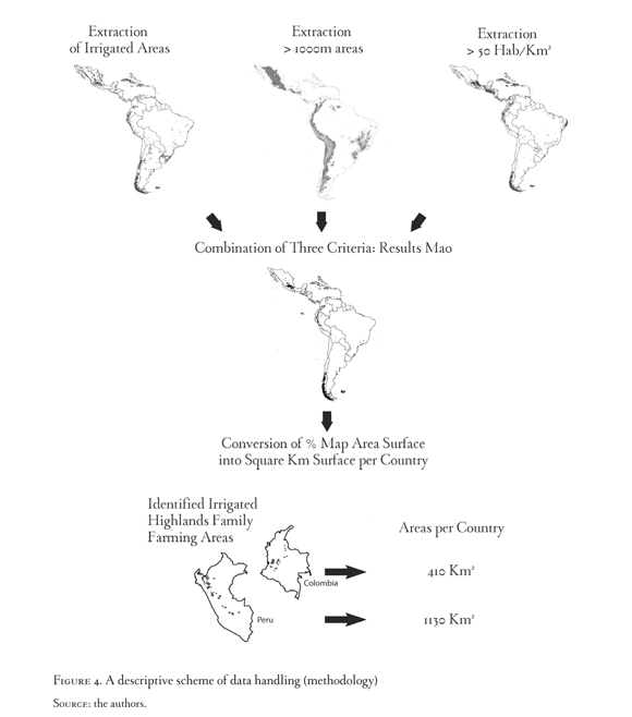
After that, we chose the data that met the three previously defined criteria for each country. Concretely, the calculation algorithm indicated the zones whose information was overlapped. This allowed us to finally determine the spatial distribution of those zones that: have an altitude above 1000 m (which, according to Zimmerer (2010), is the lowest limit for irrigated agriculture in the Andes), have rural density of more than 50 inhabitants per Km2 (data defined by the authors using the expert's criterion13), and where irrigation takes place. This last data about irrigation took the information in Siebert et al. (2007) as a basis, according to the irrigated area reported per pixel. Thus, for example, if the zone comprehended in a pixel shows that 20 per cent of it is irrigated, this represents 16.2 Km2 of irrigated area out of a total of 81 Km2 (20% of 81 Km2). The whole process is schematized in figure 5. In order to compare the obtained data, the total irrigated areas located at higher altitude than 1000 m were calculated for each country by using the same methodology and sources, but varying the selection criteria.
The cartographic manipulations done did not affect the resolution or the exactness of the data used as basis. Therefore, the reliability degree obtained is the same as the one in Siebert et al. (2007). To obtain more detailed results, the international organisms would have to provide a better resolution source maps.
In some cases, it would be possible to obtain data separately from each country. However, this would multiply the information sources, and, therefore, the difficulties in the data treatment and comparison.
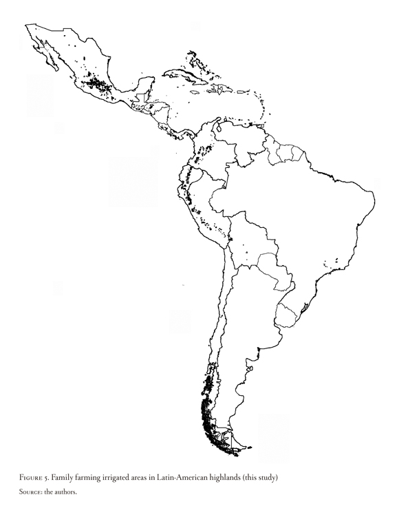
3. Results
The data management allowed us to identify, following a cartographic method, the family farming irrigated areas in the Latin-American highlands. Figure 5 shows the representative areas of family farming in the region.
Spatial information was quantified and it is shown in Chart 2. It presents totals of agricultural areas in highlands irrigated areas by family farmers, the totals of irrigated areas per country according to FAO (2102), and suggests the importance of the former, over the national totals. Some countries are not reported in the table, because no areas that met the defined criteria were found.
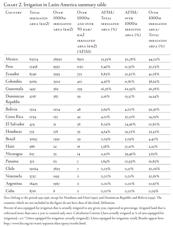
The data obtained allow relativizing the family farming irrigated area within the national context, as well as on the irrigated area above 1000 m.
The countries with the highest proportion of family farming in highlands -Mexico, Peru, Ecuador, Guatemala and El Salvador- have a strong presence of indigenous communities and a long history of highland irrigation. The weight that this type of agriculture has over the total irrigated area is an indicator of the historical continuity of these agricultural techniques, or of defined and distinctive cultural characters14.
It will be necessary to revise the data reported for Bolivia, as it was expected to have a similar behavior15. This is because Forero Alvarez et al. (2011) reported that 99 per cent of the Andean agriculture in Bolivia corresponds to family farming. On the other hand, the data concerning the irrigated zones located at an altitude higher than 1000 m obtained from FAO (2102) and Siebert et al (2007) are not consistent with what Forero Alvarez et al. (2011) and Paz Ballivián (2009) said, since they affirm that the agriculture in low zones is capitalist, which would be characterized by the use of irrigation systems. Therefore, it was not expected that the higher-than-1000 m irrigated areas represented the largest proportion. In consequence, the information obtained for this country is not conclusive and the basis data must be revised16.
A lower relative presence of highland family farm irrigation in the national context, but still representative, is observed in Colombia, Dominican Republic, Costa Rica and Honduras. These countries are located in different surroundings: the Andes, Caribbean islands and Central America, respectively, which shows wide distribution and importance of irrigated family farming in the mountains.
Brazil's relative scarcity of land over 1000 m explains why agriculture and irrigation in the highlands makes a very low percentage of the total Brazilian irrigation.
With respect to total areas, Mexico stands out among the countries with bigger family farming irrigated areas in the highlands, with 8901 km2. It is followed by Peru, with 1128 km2, Ecuador, with 773 km2, and Colombia, with 414 km2. Mexico, Peru and Ecuador are also included in the group that has a major relative weight over the irrigated totals in mountain family farming, which suggests the need to develop further research in those countries. Regarding the highest representativity of irrigated family farming in zones higher than 1000 m, in their national context, the countries that stand out are: El Salvador (74,96), Haiti17 (71,11%), Guatemala (62,59%) and Nicaragua (39,46%). They are followed by the group composed by Mexico (30,78%), Costa Rica (27,12%), Ecuador (21,50%), Honduras (19,73%), Dominican Republic (15,17%), Colombia (11,81) and Peru (11,33%).
The low presence of mountain irrigated family farming systems in Chile and Argentina, where the highland irrigated areas represent 20.06 and 10.67 percent of the national totals, respectively, can be explained by the chosen density selection criteria. An analysis in those countries needs to put in consideration the geographic land tenancy patterns, as well as the rural population density.
Although the obtained data correspond to information offered by international entities, it is surprising that Venezuela is absent. This can be due to the quality of data corresponding to the country, the dispersion of the irrigated zones in the Venezuelan Andes and, overall, because of the chosen criteria on altitude and the population impact on this country. Additionally, despite the fact that in Venezuela the mountain irrigated agriculture represents a 9 per cent out of the total (52458 ha, according to Angeliaume-Descamps, Blot, Leroy, Maire, & Molina (2011)), it is distributed in different narrow valleys whose highlands are neither irrigated nor populated. This is why the spatial resolution used, could not register such rapid spatial variations. Similar phenomena might have occurred in other countries where bigger areas were expected, just like the already discussed case in Bolivia. For this reason, it would be necessary to revise these cases particularly, which implies using data with higher resolution and trying specific limits, which must be adapted regionally.
Conclusions
Although the results presented here differ to the ones by other sources, they are derived in a transparent manner that seeks to deep into and improve the comprehension of the Latin American rural world.
For every case, mountain irrigated family farming is a minority system within the nation, as well as the highlands as a percentage of the national land mass. The highland irrigations' minor presence confirms what was said in the conceptual section of the present article. However, it contributes greatly to the national agricultural production, it is located in environmentally sensitive zones, it is part of the Latin-American rural world complex realities, and its presence can be observed in all the Latin-American regions.
The resolution we worked with, excludes agricultural mosaic zones where there is a strong presence of irrigated agriculture and where there are also conservation or non-use zones, simultaneously. Therefore, the data can undervalue the presence of such areas, just like what happened in the case of Venezuela. For this reason, we suggest deepening in the research with a better resolution of information and analysis conducted country by country or, if possible, for different regions in each country. However, the use of diverse sources will make comparison between countries problematic.
Another restriction to obtain accurate data is the dispersion of the mountain irrigated agriculture and its combination with dry crops or other land uses, which makes it difficult to visualize the irrigated areas. On the other hand, the information that includes secondary data, based on official statistics is not updated. It includes the zones that are equipped for irrigation and excludes informal (not accounted for) irrigation zones. This explains the differences in the areas reported by different authors.
The results of our cartographic analyses of irrigation, allow us to have a closer vision to this reality, particularly, its spatial distribution. However, a slight modification in the defined criteria (for example, choosing altitudes higher than 800 m, or rural densities higher than 40 inhabitants per km2) could widely change the results obtained for each country, in terms of surface. It would be pertinent to test those limits and reflect on those that would be the most representative ones. To come closer to reality, it would be doubtlessly optimal to define different limits according to each country, depending on its national characteristics. Thus, for example, it would be interesting to adjust those data treatments for the countries with the biggest relative and total areas object of study. Those countries would be, for instance, Mexico, Peru, Colombia, Ecuador, Haiti, Guatemala, Dominican Republic, Costa Rica or El Salvador.
Foot Note
1FAO use 26 variables to describe irrigation and agricultural land use in the world. Data are principally obtained in http://faostat.fao.org/ site that allows the generation of databases on land and water statistics. Water statistics are obtained from the AQUASTAT site, http://www.fao.org/nr/water/aquastat/ data/query/index.html. These tools constitute the main world database which counts the irrigated agriculture surfaces according to the soil use (permanent crops, seasonal crops, permanent and temporary grasslands and pastures), irrigation types (sprinkler, flood, others), per country and per year (from i960 or 1961 to 2009 or 2010). Nevertheless, not all the categories, countries or years are systematically available. Even so, a big quantity of data can be cross-referenced, at a Latin-American or each-country scale, in order to represent the percentage or maps of the actual situation and the evolution in time of soil used for agriculture in the region.
2The Shuttle Radar Topography Mission consists in obtaining an elevation digital model of the globe's zone comprehended between 56 °S and 60 °N, so that a complete high-resolution digital topographic earth maps base is generated. It is an international project developed by the American National Geo-spatial Intelligence Agency, NGA, and the National Aeronautics and Space Administration, NASA. Data is available in http://srtm.csi.cgiar.org/
3Taken from: http://www.fao.org/geonetwork/srv/en/main.home
4One of these particular cases is seen in Mexico when the water policy (Ley del agua) in 1992 introduced reforms, which had an impact on the country's irrigation districts organization and operation.
5Translated from Spanish
6This process is not exclusive of Latin America since worldwide investments in irrigation tend to concentrate in big scale projects (Gender and Water Alliance, 2007).
7Two regions can be distinguished in Mexico: a Northern Region, where horticulture is industrialized, developed in big extensions of land, and mainly directed to export markets, and a Central Region, where horticulture is developed in small family farms and is mostly destined to local and regional markets.
8These are general data that must be read carefully as they do not show the great variability given between the different countries and even inside each country.
9Nevertheless, he showed that even farms of ï00 ha could still be classified as family farming, and found that it is the farms between 3ï and 67.8 ha the ones that define optimal conditions for family farming in Brazil.
10The data that has the least reliable resolution is taken as the main data. The use of further data which have better resolution allow us not to degrade the data that matter most to our purpose.
11Vectorizing an image consists in transforming it into a group of geometrical forms (dots, lines and polygons).
12An equivalent projection allows conserving surfaces.
13This information corresponds to saying that a family composed of five members manage an area of or smaller than 10 ha (not all of them irrigated or cultivated). This size, although defined arbitrarily by the authors and which does not meet the criteria given by the authors taken as reference, is within acceptable ranges, and allows us to establish that, because of the land size, working labor is mainly familial; additionally, it allows us to include activities in which the territory is not used, since the rural zones comprehend non-cultivable or conservation zones. Family farming zones that have lower population density are not taken into consideration in this study.
14Additionally, family farming has the highest participation out of the national total in Mexico and Peru, thanks to the revolution in Mexico and the agrarian reform in Peru.
15This is mainly explained by the minimum rural population density defined.
16We suppose Bolivia' data report only public irrigation systems and do not include private irrigation systems which are located basically in the east low lands.
17Although the higher than 1000 m irrigated area in Haiti represents only 2,22% of the national total.
References
Angeliaume-Descamps, A., Blot, F., Leroy, D., Maire, E., & Molina, L. E. (2011). Angéliaume-Descamps A., Blot F., Molina L., Leroy D., Maire E. Peltier A. & Antoine J. M. (à paraître) Construction des ressources en eau au sein d'un espace agricole et protégé de montagne tropicale: Les facteurs de la mise en place d'une gestion partici. Journées de Géographie Tropicales. Toulouse: L'harmattan. [ Links ]
Angeliaume-Descamps, A., & Gutiérrez-Malaxechebarría, A. (2012). Modèles d'irrigation dans les petits systèmes maraîchers des Andes vénézuéliennes et colombiennes. [ Links ]
Angeliaume-Descamps, A., & Oballos, J. (2009). Le maraîchage intensif irrigué dans les hautes vallées andines vénézuéliennes: quelle remise en question? Les Cahiers d'Outre-Mer, (247), 439-468. [ Links ]
Boelens, R. (2009a). The politics of disciplining water rights. Development and Change, 40(2), 307-331. Retrieved from http://onlinelibrary.wiley.com/doi/10.1111/j.1467-7660.2009.01516.x/full [ Links ]
Boelens, R. (2009b). Aguas diversas . Derechos de agua y pluralidad legal en las comunidades andinas. Anuario de Estudios Americanos, 66(2), 23-55. [ Links ]
CGIAR-SCI. (2008). SRTM 90m DEM Digital Elevation Database. Retrieved February 21, 2012, from http://srtm.csi.cgiar.org/ [ Links ]
Carmagnani, M. (2008). La agricultura familiar en América Latina. Problemas del desarrollo, 39(153), 11-56. [ Links ]
Chiriboga, M. (1999). Desafíos de la pequeña agricultura familiar frente a la globalización. In L. Martínez (Ed.), El Desarrollo Sostenible en el Medio Rural. Quito: FLACSO. [ Links ]
Cremers, L., Ooijevaar, M., & Boelens, R. (2005). Institutional reform in the Andean irrigation sector: Enabling policies for strengthening local rights and water management. Natural Resources Forum, 29(1), 37-50. doi:10.1111/j.1477-8947.2005.00111.x [ Links ]
De Vos, H., Boelens, R., & Bustamante, R. (2006). Formal Law and Local Water Control in the Andean Region : A Fiercely Contested Field. Water Resources, 22(1), 37-48. doi:10.1080/07900620500405049 [ Links ]
FAO. (2000). El riego en América Latina y el Caribe en Cifras. English (p. 348). Rome: FAO. [ Links ]
FAO. (2007, July 2). GeoNetwork open source portal to spatial data and information. Retrieved from http://www.fao.org/geonetwork/srv/en/main.home [ Links ]
FAO. (2010). A policy programme for family farming. Thirty-first regional conference for Latin America and the Caribeanrt. Retrieved October 10, 2010, from http://www.fao.org/docrep/meeting/018/k7338E.pdf [ Links ]
FAO. (2012). AQUASTAT database, Food and Agriculture Organization of the United Nations (FAO). Retrieved August 13, 2012, from http://www.fao.org/nr/water/aquastat/data/query/index.html?lang=en [ Links ]
FAO, & BID. (2007). Políticas para la agricultura familiar. (F. S. Baquero, M. Rodríguez Fazzone, & C. Falconi, Eds.) (pp. 1-34). Santiago de Chile: FAO. [ Links ]
Forero Alvarez, J., Corrales Roa, E., Estévez Moreno, L., Correa Pinilla, D. E., Galeano Medina, J., Villareal Fuentes, M., ... Cuellar, O., (2011). Proyecto: Viabilidad económica y ambiental de sistemas de producción familiares agropecuarios sostenibles en los países andinos. SISPANDI. (p. 251). Bogotá [ Links ].
Gender and Water Alliance. (2007). Género, Agua para la Agricultura e Irrigación. Guía de Recursos Transversalización del Enfoque de Género en la Gestión del Agua. Retrieved March 21, 2012, from http://www.es.genderandwater.org/page/3563 [ Links ]
Girard, S. (2005). Les páramos, espace stratégique pour la gestion de l'eau dans les Andes septentrionales: le bassin-versant du río Ambato (Equateur). M@ppemonde, (78), 12. [ Links ]
Godoy, R., Morduch, J., & Bravo, D. (1998). Technological adoption in rural cochabamba , bolivia. Journal of Anthropological Research, 54(3), 351-372. [ Links ]
Gutiérrez-Malaxechebarría, A. (2011). Un agricultor en Fómeque, otro en el Armañac: grandes diferencias con muchos puntos en común. VII Seminario Internacional de Desarrollo Rural, Bogotá, 2011. [ Links ]
Jauregui, P., Olivares, R., & Colque, L. (2005). Efectos del riego en los ingresos de las familias campesinas. Cochabamba, Bolivia: Programa de Desarrollo Agropecuario Sostenible GTZ - PROAGRO UCORE. [ Links ]
Le Goulven, P., & Ruf, T. (1993). The functioning of peasants' managed irrigation in the northern ecuadorian andes (Mira Watershed). In S. Manor & J. Chambouleyron (Eds.), Performance and Measurement in Farmer-Managed irrigation Systems. Proceedings of an international workshop of the farmer-managed irrigation system network (p. 264). Colombo, Sri Lanka: International irrigation Management Institute (IIMI). [ Links ]
Le Goulven, P., & Ruf, T. (1994). Funcionamiento del riego tradicional en los andes ecuatorianos. Recomendaciones para el Plan Nacional de Riego. Resumenes de las comunicaciones presentadas en el ciclo de conferencias por los 20 años del Ortstom en Ecuador (pp. 99-105). ORSTOM. [ Links ]
Leiva, A., & Skees, J. (2008). Using Irrigation Insurance to Improve Water Usage of the Rio Mayo Irrigation System in Northwestern Mexico. World Development, 36(12), 2663-2678. doi:10.1016/j.worlddev.2007.12.004 [ Links ]
Linck, T. (2006). Prefacio. In Y. Villagómez Velázquez (Ed.), Política hidroagrícola y cambio agrario en Tehuantepec, Oaxaca (1st ed., pp. 13-26). Zamora, Michoacán: El Colegio de Michoacán. [ Links ]
Maldonado Rojas, T. (2000). Transferencia de Sistemas de Riego a los Usuarios en países de América Latina y el Caribe (p. 44). Santiago de Chile: FAO. Retrieved from http://www.bosquesandinos.info/CESA/CESA_AG_0181.pdf [ Links ]
Palerm-Viqueira, J. (2010). A comparative history, from the 16th to 20th centuries, of irrigation water management in Spain, Mexico, Chile, Mendoza (Argentina) and Peru. Water policy, 12(6), 779-797. Retrieved from http://cat.inist.fr/?aModele=afficheN & cpsidt=23531793 [ Links ]
Prime, S. (2010). Soutenabilité de l'agriculture maraîchère dans les hautes vallées de Puebla (Mexique): enjeux au fil de l'eau. Vie Congrès européen CEISAL. Independencias, Dependencias, Interdependencias. Toulouse. Retrieved from http://halshs.archives-ouvertes.fr/CEISAL2010/es/ [ Links ]
Ramírez J., J. (1999). Ajuste Estructural y Estrategias Campesinas de Reproducción en el Valle de Puebla, México. Campus Puebla- Colegio de Postgraduados (México). [ Links ]
Robles Mendoza, R. (2010). Sistemas de riego y ritualidad andina en el valle del Colca. Revista Española de Antropología Americana, 40(1), 197-217. [ Links ]
Ruf, T., & Gasselin, P. (1999). Irrigation de montagne. Les Andes Equatoriens. [ Links ] Ruf, T., & Mathieu, P. (2001). Water rights and the institutional dynamics of irrigated systems: between State, market and community action. International Journal ofWater, 1, 3-4. [ Links ]
Siebert, S., Doll, P., & Feick, S. (2007). The Global Map of Irrigation Areas Version 4.0.1. Earth. Rome: FAO. [ Links ]
Siebert, S., Doll, P., Hoogeveen, J., Faures, J. M., Frenken, K., & Feick, S. (2005). Development and validation of the global map of irrigation areas. Hydrology and Earth System Sciences, 9(5), 535-547. doi:10.5194/hess-9-535-2005 [ Links ]
Smith, L. D. (2002). Reforma y descentralización de servicios agrícolas un marco de políticas. FAO. Retrieved from http://www.fao.org/docrep/005/y2006s/y2006s00.htm [ Links ]
Thenkabail, P., Biradar, C., Noojipady, P., Dheeravath, V, Li, Y., Velpuri, M., ..., Gumma, M. (2009). Global irrigated area map (GIAM), derived from remote sensing, for the end of the last millennium. International Journal of Remote Sensing, 30(14), 3679-3733. doi:10.1080/01431160802698919 [ Links ]
Vanacker, V, Govers, G., Poesen, J., Deckers, J., Dercon, G., & Loaiza, G. (2003). The impact of environmental change on the intensity and spatial pattern of water erosion in a semi-arid mountainous Andean environment. Catena, 51, 329-347. doi:10.1016/S0341-8162(02)00172-8 [ Links ]
World Bank. (2007). Rapport sur le développement dans le monde 2008. L'Agriculture au service du développement (p. 27). Washington: World Bank. [ Links ]
World Water Assessment Programme. (2009). The United Nations World Water Development report 3: Water in a changinf world. World Water (p. 349). Paris: UNESCO. [ Links ]
Zimmerer, K. S. (2000). Rescaling irrigation in Latin America: the cultural images and political ecology of water resources. Cultural Geographies, 7(2), 150-175. doi:10.1177/096746080000700202 [ Links ]
Zimmerer, K. S. (2010). Woodlands and Agrobiodiversity in Irrigation Landscapes Amidst Global Change: Bolivia, 1990-2002*. The Professional Geographer, 62(3), 335-356. doi:10.1080/00330124.2010.483631 [ Links ]
van der Zee, J. J., Fajardo Reina, A., & Holtslag, H. (2002). The impact of farm water supply on smallholder income and poverty alleviation along the pacific coast of Nicaragua. A case for low cost technology solutions. Africa. Managua. [ Links ]
von Benda-Beckmann, F., von Benda-Beckmann, K., & Spiertz, J. (1998). Equity and legal pluralism: taking customary law into account in natural resource policies. In R Boelens & G. Dávila (Eds.), Searchingfor Equity. Conceptions of Justice and Equity in Peasant Irrigation (pp. 57-69). Assen: Van Gorcum. [ Links ]
