


Services on Demand
Journal
Article
 English (pdf)
 Article in xml format
 Article references
 Send this article by e-mail
Indicators
-
 Cited by SciELO
 -
 Access statistics
Related links
-
 Cited by Google
 -
 Similars in
SciELO
Similars in
SciELO -
 Similars in Google
Share

 Permalink
CT&F - Ciencia, Tecnología y Futuro
Print version ISSN 0122-5383On-line version ISSN 2382-4581
C.T.F Cienc. Tecnol. Futuro vol.3 no.1 Bucaramanga Jan./Dec. 2005
Abstract: The seismic records of Colombian foothills are usually noisy and contaminated by coherent and high amplitude back-scattered associated with roughness topography, which obscure reflectors from deeper layers. To remove this back-scattered noise, filters have been applied getting satisfactory results for smooth topography and short offsets, but in general conventional methods yield unsatisfactory results. We applied an approach based in prediction and subtraction of the unwanted noise to attenuate it.
The extracted source signature of each record and the shallow velocity model were input to the finite element software to model the acoustic wave equation, obtaining the back-scattered noise in each record. Each output was subtracted from its corresponding record, attenuating noticeably the noise. The procedure was applied in the shots records of a foothill seismic line providing an improved image of the stacked section after time processing. The software had been previously tested on synthetic data giving promising results.
Keywords: scattering noise, foothill area, attenuation, modeling, rough topography, weathering layer.
Resumen: Los registros del área del piedemonte colombiano están generalmente contaminados con ruido de gran amplitud asociado a la topografía, que oscurecen los reflectores de interés. Este ruido se intenta eliminar mediante filtros, lo cual funciona para topografía suave y offsets más cercanos, pero en general los métodos convencionales suministran resultados desalentadores. Hemos aplicado un método basado en la predicción y sustracción de este ruido con el fin de atenuarlo.
La ondícula extraída de cada registro y el modelo de la capa somera, son alimentados a un programa hecho en elementos finitos que modela el comportamiento de la onda acústica y suministra la respuesta de la capa somera. Cada salida se sustrae de su correspondiente registro de donde se extrajo la ondícula, logrando un registro y una atenuación notable en él.
Este procedimiento se aplicó a una línea sísmica de piedemonte, obteniéndose una mejor imagen de la sección apilada. El programa había sido previamente probado en datos sintéticos suministrando resultados promisorios.
Palabras clave: ruido, piedemonte, atenuación, modelamiento, topografía rugosa, capa meteorizada.
INTRODUCTION
Colombia has largely focused its oil exploration in foothill areas, which are characterized by complex geology, rough topography, large variations in surface elevation and variable near-surface velocity. Compared with areas of milder topography changes, the foothill seismic images are usually poor, pointing the influence of topography and near-surface conditions in image quality. These noise distortions affect phase and amplitude content of the signal, causing severe stack attenuation and making poststack recovery difficult. The waves reflected in the surface behave as multiples in the weathering layer, behaving like a high amplitude and coherent noise in seismic records. Since velocity contrast is usually large at the near surface, acoustic impedance contrast is large as well, what accounts for the noisy events to be large-amplitude and to become trapped in a guided-wave fashion. Due to their large amplitude and time extent, this noise overlay the information from deep reflectors. To remove this unwanted events procedures like frequency filtering and multi-channel (f-k or τ-p) filtering or predictive deconvolution, are often used. However, the non-repetitive character of the back-scattered noise arisen from the complexities in its generation and wave behavior in near surface layers, make those techniques got poor results.
Recent approaches have been considered to tackle this problem (Ernst et al., 2002; Guan et al., 2000; Fu et al., 1999; Campman et al., 2003), a strategy in the same direction was presented before, getting appreciable noise attenuation on shots (Montes et al., 2003). The main goal is to predict and subtract the noise from contaminated data, the back-scattered
noise prediction is accomplished in a wave theoretical fashion by finite-element, acoustic wave-equation modeling. Irregular and rapid variations in surface elevation are involved in the generation of the wave phenomena we want to study, so those variations should be accurately included in our implementation; a finite-element formulation is particularly suited to the representation of irregular model features and is therefore a very convenient choice for our purposes. Due to its deterministic nature, this procedure is founded on the assumed knowledge of:
- A velocity model for the surface and shallow earth.
- The source signature; furthermore, the scalar wave equation is used, so that density information is not needed.
We also assume that the coherent noise events of interest are generated only from wave propagation in the shallow near surface, so that those can be isolated from other events in the data, and in particular information from deeper layers need not to be included in the velocity model. Also from that assumption, simulation of wave propagation in such a model provides a prediction of the coherent noise which could then be subtracted from the data to obtain a noise-free record.
The algorithm had been tested and validated in a controlled experiment on synthetic and field data from a foothill area in Colombia (Montes et al., 2003). The shallow earth model was obtained by first-arrival tomography and the source signature was estimated by wavelet extraction from each field record. In both cases noise was noticeably reduced.
In the seismic data line, the image of deep reflectors was improved in the stacked section, after application of the method.
WAVE EQUATION AND FINITE ELEMENTS
The Finite Element method (FE) is widely used and accepted for the numerical solution of differential equations of the mathematical-physics. As noted above, a finite-element algorithm was chosen for our implementation for the convenience of accurately representing the irregular variations of the surface topography that it is essential to our purpose of modeling wave phenomena associated to the presence of those irregularities.
The FE method first discretizes the model introducing a grid in space formed by a set of related elements.
The well known Helmholtz´s wave equation, that governs the behavior of compressive waves, is transformed using the Galerkin´s matrix formulation in space and second order derivative in time, into a system of equations calculating the contribution of each element to the whole system and placing the value into their correct positions within the final system of equations (a more detailed explanation can be found in specific textbooks, i.e. Zienkiewicz, 1992):
Here M and K are called the mass and stiffness matrices respectively, {f} is the source vector, {u} is the unknown field vector, which in our case is acoustic pressure differential and {ü} denotes its second timederivative. The mass matrix initially was not diagonal, but it was convenient to use the lumped mass matrix to increase the efficiency. Equation 1 contains one row for each element of the model. A grid in time with points tn=n?t is introduced representing {u}n the value of the field at n time sample. We assumed in the topography surface a free surface boundary condition {u} = 0 and initial conditions u(x,0)=f(x) and Δu/Δt=0.
On an element with m nodes the field is expressed by 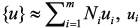 is the field value on i-node and Ni the corresponding shape function.
The contribution from e-element to the coupling of node local i and j to the global system mass matrix is 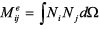 and the similar contribution to the global system stiffness matrix is given by
 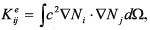 , where ? denotes the e-element in physical coordinates (Zienkiewicz, 1992).
According the implicit forward Euler scheme, Equation 2 can be written as:
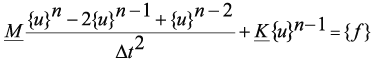
Manipulating Equation 2, it can be transformed on a more computationally attractive form and the set of linear equations now can be solved at each time step providing the following discrete solution (Langtangen, 1996):

With a lumped M, the extreme right term of Equation 3 becomes trivially computed.
Equation 3 expresses {u} in terms of the known fields one and two time steps earlier, representing a recursive procedure for n > 0. When n=0 we need to take the established initial conditions into account, which results in {u}-1 = {u}0. Using this result to eliminate {u}-1 gives the following formula that must be used for the first time step:
To simulate equation, the algorithm must set the initial conditions (4) and compute the field at each time level using Equation 4 recursively.
The algorithm was implemented in a C++ code under Diffpack 1.4, which is a public-domain version of the Diffpack package, from the University of Oslo (Langtangen, 1999). A prototype code by Langtangen (1996) was used and modified to fit our purposes. The code simulates waves in a variable-velocity medium with a velocity model and a source signature as input. To minimize run time and computer memory usage, the program only keeps and stores in external output the field values in those nodes defined as receiver positions.
METHODOLOGY
Because backscattered noise is generated by a specific mechanism associated to topography and shallow layers it is possible to model the noise present in the data set. Thus the removal of noise approach becomes a two step process: modeling and then subtraction of the modeled noise events from the input gather. The proposed method and the algorithm were applied to field data from a 2D seismic line acquired on a foothill area in Colombia. The acquisition parameters for this line includes a 15 m group interval, 45 m shot interval, 7,5 m shortest offset, split spread, 2 ms sampling rate and a 5 s total record length. Due to limitations in the available computational capabilities, the data included in the experiment was limited to 24 shots, 66 receivers and 1 s trace length.
The first methodological step intends to estimate the shallow velocity model from surveyed data; the model may include the most top layers, but in this particular research just one stratum was considered, representing the weathering layer. A former model was obtained from conventional refraction statics flows provided with ProMAX, which considers uphole-time data for the estimation of velocity in the weathering layer, later this shallow velocity model was refined by first-arrival tomography using GLI3D software.
With the anterior information a finite-element velocity model was built as shown in Figure 1, it represents the surveyed surface elevation and the estimated weathering layer thickness obtained before, placed over a semi-infinite homogeneous media with a constant velocity value equal to replacement velocity. The build model is represented by a grid with 27322 nodes and 36787 rectangular elements, each one with sides ?x = ?y = 7,5 m, this value together with velocity values satisfied Courant condition needed to guarantee the stability in algorithm performance.

The second step tries to estimate source signature for each shot considered as a minimum-phase wavelet and being extracted from a subset data of the corresponding common shot gather. Since the field records were heavily contaminated with ground-roll, for this procedure the data was preconditioned by application of a zero-phase bandpass filter in the 15-60 Hz frequency range.
In the third step the extracted source wavelet and the constructed finite element model, including velocity field, are input to the mentioned program simulating the acoustic wave propagation in the zone, furnishing a register of the shallow model response.
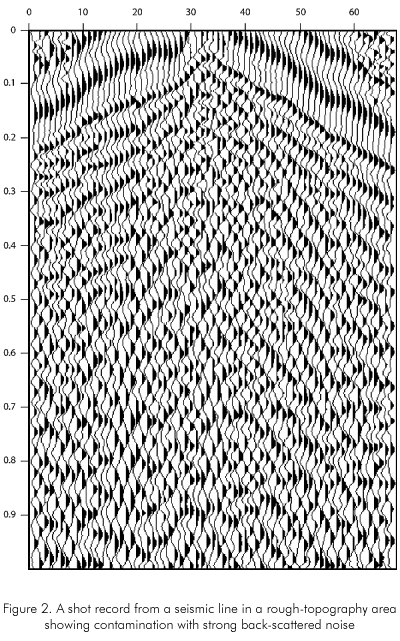
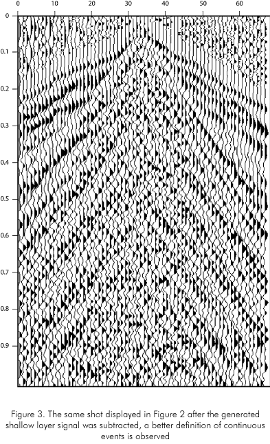
Finally, in the fourth step the register of the shallow model response is numerically subtracted trace by trace from the raw shot, providing a shot free of weathering layer response, one of this kind of shot obtained is seen in Figure 2.
Only 24 shot records with the same acquisition geometry of seismic line were generated using the finite element modeling code, with the sources located 7,5 m below the topographic surface. Each generated record was subtracted, as mentioned above, from the corresponding field record, furnishing a clean shots set.
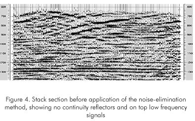
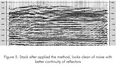
At the end, the data set with the 24 original records and the output data set containing the 24 corresponding clean records were processed separately applying the same conventional ProMAX flows obtaining two stacked sections. Figure 4 shows the stacked section obtained by conventional process flows, otherwise Figure 5 display the new contrasting stacked section provided by the same process but feed with the cleaned data set.
DISCUSSION
An anterior work showed promissory results cleaning Colombian foothills records contaminated with high amplitude noise (Montes et al., 2003).
Recalling those mentioned results, Figure 2 shows a field records strongly contaminated with coherent noise. There, the back-scattered noise is not prevalent over the whole record since other noise events like ground-roll are also observed; no clear reflections can be seen in the data. The same record after the modeled response from the near surface and the topography has been subtracted is displayed in Figure 3. It looks different from the original data: since the back-scattered noise has been attenuated the ground roll is now dominant, and the first arrivals are more clearly observed; but also no clear reflection events can be seen. Here, similar results were obtained on the others records of the original data set.
A further comparison is presented between the stacked section obtained from the original data in Figure 4, and that obtained using the data after application of the subtraction procedure in Figure 5. At 920 ms a continuous reflector crossing the section from left to right is enhanced in Figure 5, not visible in the Figure 4. It limits an upper layer not clearly seen before. Besides that, the whole stacked section now looks clean with sharper reflector appearance.
A second layer below the anterior, based at 1230 ms, shows a pack of parallel reflectors, showing the recovering of overlapped information not evident in Figure 4.
Because the predictive and subtract nature of the approach, it does not modify the phase and amplitude spectra of overlapped information, increasing the content of information available in each seismic record.
The methods used in conventional processing routines usually diminish the procurated signals and modify its spectra contents, trying to eliminate the phenomena analyzed here. The main reason for those methods failure, is the non-repetitive character of the back-scattered noise events.
It can be seen that the method has worked to improve the quality of the stacked section. The image of the subsurface is cleaner when the shot records are processed with the approach analyzed here. First, in the definition of reflections not present in the original section, second, in the improved continuity and character of several of the reflections and finally, in the attenuation of the noise observed in the shallow part of the original section.
CONCLUSIONS
• Coherent and high amplitude noise generated from back-scattering in the surface topography is often present in land seismic data from rough-topography areas. The presence of those events commonly obscures the information of most interest from deeper layers, deteriorating the quality of the seismic images.
• To attenuate this noise in data acquired in such a hostile area for seismic activities, a method founded in the solution of the acoustic wave equation by a finite-element approach is suggested. Application of the method indeed results in elimination of noise and improvement of the quality of the seismic images in rough-topography areas, as demonstrated on field data from Colombian foothills. Extension of the method to elastic and 3D cases is envisaged; in the elastic case, hopefully ground-roll can also be accounted for and hence attenuation of this kind of noise can be attempted.
• The method presented and the algorithm used here result in correct phase alignment, enhanced stacking fidelity and broadened signal bandwidth; making plausible to interpret and map subtle stratigraphic plays in Colombian foothill zones.
• Some noise residuals can remain due to the non perfect matched model. However, according stacked section obtained, these residuals are smaller than those provided by methods already available.
ACKNOWLEDGMENTS
The authors wish to thanks Colciencias, the Colombian government agency for promotion of scientific work, by the partial financial given to this project, also to the Universidad Nacional de Colombia and Instituto Colombiano del Petróleo (ICP) by the sponsor furnished. Petrobras and Ecopetrol S. A. provided field data, Halliburton LatinAmerica S.A and Ecopetrol S. A. provided access to commercial software used in the project.
REFERENCES
1. Campman, X., Van Wijk, K., Scales, J. and Herman, G., 2003. “Measuring, imaging and suppressing scattered surface waves”. 73rd Ann. Internat. Mtg., SEG, 1897-1900. [ Links ]
2. Ernst, F., Herman, G. C. and Ditzel, A., 2002. “Removal of scattered guided waves from seismic data”. SEG, 67: 1240-1248. [ Links ]
3. Fu, L. -Y., Guan, H. and Wu, R. S., 1999. “Removing rugged- topography scattering effects in surface seismic data”. 69th Ann. Internat. Mtg., SEG, 453-456. [ Links ]
4. Guan, H., Wu, R. S. and Fu, L. -Y., 2000. “Removing scattering effects of rugged topography using finite-difference method”. 70th Ann. Internat. Mtg., SEG, 2189-2192. [ Links ]
5. Langtangen H. P., 1999. “Computational Partial Differential Equations: Numerical methods and Diffpack programming”. Springer, Verlag. [ Links ]
6. Langtangen H. P., 1996. “Efficient Element Solution of the Linear Wave Equation in Diffpack”. The Diffpack version 1.4 Report Series. SINTEF. University of Oslo, Norway. [ Links ]
7. Montes Luis, Quintana Robinson, Céspedes Sandra, Espíndola Nancy, Salinas Trino and Pérez Gabriel., 2003. “At tenuation of the seismic dispersion associated to foothill topography: application to real data”. CT& F – Ciencia, Tecnología y Futuro, 2 (4):1-6. [ Links ]
8. Zienkiewicz, O., 1992. “Finite Element Method”, Vol. 2, McGraw Hill, New York. [ Links ]

