


Services on Demand
Journal
Article
 English (pdf)
 Article in xml format
 Article references
 Send this article by e-mail
Indicators
-
 Cited by SciELO
 -
 Access statistics
Related links
-
 Cited by Google
 -
 Similars in
SciELO
Similars in
SciELO -
 Similars in Google
Share

 Permalink
CT&F - Ciencia, Tecnología y Futuro
Print version ISSN 0122-5383On-line version ISSN 2382-4581
C.T.F Cienc. Tecnol. Futuro vol.3 no.4 Bucaramanga Jan./Dec. 2008
2Instituet fuer Geowissenschaftten Universitaet Potsdam, Potsdam, Germany e-mail: andres.mora@ecopetrol.com.co
(Received May 15, 2008; Accepted Nov. 14, 2008)
* To whom correspondence may be addressed
ABSTRACT
For the first time we show geological evidence of unambiguosly documented footwall shortcuts adjacent to the trace of inverted master nomal faults, in the Eastern Cordillera of Colombia. The Eastern Cordillera is an orogen whose width and location are traced by a Mesozoic graben. However, few structures related with the graben have been documented up to the date. In this study we propose the Ariari-Guatiquía region as a type location for a unique observation of footwall shortcuts. The master normal faults in the Ariari-Guatiquia region, and documented in this manuscript, were active during the Lower Cretaceous, partially inverted during the Andean orogenesis (since the Oligocene at least) and active still nowadays. In the hangingwall basins of those master normal faults, like the Servitá fault, all the Cretaceous syn-rift sequence has been deposited and maximum paleo temperatures in the lowermost Cretaceous rocks are higher than those for the Zircon FT partial annealing zone (~250°C; 23,15 K). In contraction, the inverted master normal faults are high angle basement involved features that generated the main topographic contrast and exposing Lower Cretaceous units or older. In contrast, in the adjacent footwall shortcuts only part of the syn-rift Lower Cretaceous sequence was deposited or more commonly was not deposited at all. Maximum paletemperatures reached by the basal Cretaceous units exposed in the hanging wall blocks of the footwall shortcuts are always less than those of the Zircon FT partial annealing zone (~250°C; 23,15 K). Finally we use AFT data to document that the footwall shortcuts originated during the Late Miocene and later as shallowly dipping faults generating low elevation hanging wall areas. All the described features are present in the Ariari-Guatiquia region. However, northwards and along strike in the Eastern foothills there is a lot of partially analogue scenarios with respect to those described in the Ariari-Guatiquia region. Therefore we deduce that a similar structural segmentation should be present along the entire Eastern foothills of the Colombian Eastern Cordillera. Based on that we propose plausible candidates for master inverted normal faults and footwall shorcuts in other areas of the Eastern foothills.
Key words: footwall shortcuts, Ariari-Guatiquia-Region, eastern cordillera of Colombia, inversion tectonics, Servitá fault, vitrinite reflectance, lower cretaceous.
RESUMEN
Por primera vez se muestran evidencias geológicas de fallas de atajo cuya documentación es inequívoca. Estas fallas son adyacentes al trazo de fallas normales invertidas en la Cordillera Oriental de Colombia. La Cordillera Oriental es un orógeno cuya anchura y localización son definidas por un graben Mesozoico. Sin embargo, pocas estructuras relacionadas con el graben han sido documentadas hasta la fecha. En este estudio se propone la región del Ariari-Guatiquía como localidad tipo que permite una observación única de fallas de atajo. Las Fallas normales principales de la región del Ariari-Guatiquía, documentadas en este manuscrito, fueron activas durante el Cretaceo Inferior, parcialmente invertidas durante la Orogenia Andina (desde el Oligoceno por lo menos) e incluso son activas en el presente. En las cuencas del bloque colgante de estas fallas principales, como la falla de Servitá, se depositó toda la secuencia Cretácica syn-rift y posteriormente las máximas paleo temperaturas alcanzadas por la secuencia Cretácica fueron mas altas que aquellas correspondientes con la zona de borrado parcial de las trazas de fisión en zircones (~ 250°C; 23,15 K). En contracción, las fallas normales principales se convierten en fallas de alto ángulo con basamento implicado que generan el máximo contraste topográfico y exponen unidades del Cretáceo Inferior o más antiguas. Por contraste, en las fallas de atajo adyacentes solo se depositó parte de la secuencia syn-rift del Cretáceo Inferior o en muchos casos no hubo en absoluto depositación del Cretáceo Inferior. Las máximas paleo temperaturas alcanzadas por las unidades del Cretáceo Inferior depositadas en los bloques colgantes de las fallas de atajo son siempre menores que aquellas de la zona de borrado parcial de trazas de fisión en zircones (~ 250°C; 23,15 K). Finalmente se utilizan datos de trazas de fisión en apatitos para documentar que las fallas de atajo se originaron durante el Mioceno tardío y después, como fallas de bajo angulo generando áreas de bloque colgante de poca elevación. Todas las características descritas se observan en la región del Ariari-Guatiquía. Sin embargo, al norte y a lo largo del rumbo en el Piedemonte Oriental de la Cordillera Oriental se observan dominios estructurales con características parcialmente análogas respecto a aquellas observadas en la región del Ariari-Guatiquía. Por consiguiente se deduce que una segmentación similar debe estar presente a lo largo de todo el Piedemonte Oriental de la Cordillera Oriental. Con base en esto se postulan candidatos plausibles para ser fallas normales principales invertidas y para ser fallas de atajo.
Palabras Clave: fallas de atajo frontal, región Ariari Guatiquia, Cordillera Oriental de Colombia, inversión tectónica, falla de Servitá, reflectancia de vitrinita, cretáceo temprano.
INTRODUCTION
Understanding what causes a pattern of deformation in a given setting is fundamental in oil exploration as an additional way to predict which traps are more likely associated with successful oil accumulations (Baby et al., 1995; Echavarría, Hernández, Allmendinger, & Reynolds, 2003; McClay, 1995; Mitra, 1993; Underhill, & Patterson, 1998). In many cases there is also a close association between the deformation pattern and the differences in the timing of deformation (Baby et al., 1995; Dunn, Hartshorn, & Hartshorn, 1995; Echavarría et al., 2003). In such cases, usually the well exposed better studied type locations for a given deformation pattern are used to infer similar behaviours in areas where geology or available information provide a less clear picture. However, to decipher what controls the structural styles and timing of deformation in prestrained areas around the world is probably even more challenging because pre-existent crustal anisotropies may have conditioned a deformation partitioning more difficult to predict (Coward, Enfield, & Fischer, 1989; Hetzel & Strecker, 1994; Ring, 1994; Paton & Underhill, 2004).
Fault reactivation and inversion are probably the most common ways of accommodating deformation in pre-strained areas (Hayward & Graham, 1989; Huyghe & Mugnier, 1995; Lowell, 1995; Underhill & Patterson,1998;). Inversion tectonics is a term that groups all those deformation processes where areas of previously negative structural relief become areas of positive structural relief mostly due to a change from an extensional to a compressive stress regime (Cooper & Williams, 1989; McClay, 1995; Yamada & McClay, 2004). Such processes have been widely identified worldwide (e.g. Cooper & Williams, 1989; Lowell, 1995). However, in some structural settings where positive inversion has been suggested, diagnostic inversion features are less clearly identified. In such cases only indirect evidence is used to infer inversion tectonics. This is the case of the Eastern Cordillera of Colombia. In this area the first regional studies (Colleta, Hebrard, Letouzey, Werner, & Rudkiweicz 1990; Cooper et al., 1995) suggested that the spatial changeover from a former Lower Cretaceous depocenter located in areas of present day high relief to flat lying areas in the adjacent Llanos foothills where such record is abstent, allowed them to propose the Eastern Cordillera as a Lower Cretaceous inverted graben. However, only recent works (Mora et al., 2006; Kammer & Sanchez, 2006) identified features inequivocally associated with inversion tectonics.
A critical issue in areas of inversion tectonics is the degree of dependence of the contractional structural style on the former extensional tectonic inheritance. In many cases inversion of former faults is the dominant mechanism. In other cases, especially in listric faults, high angle segments are not very easy to reactivate in presence of subhorizontal compressional stresses, even if there is a low cohesion and friction pre-existing plane (Huyghe & Mugnier, 1992a; Huygue & Mugnier, 1992b). In those cases a new fault plane develops branching from the lower angle inverted segments. This new faults branching from the inverted faults are termed footwall shortcuts (Huygue & Mugnier, 1992a).
In this work, based on a detailed field mapping work and compilation of surface and subsurface information we propose that the area of the southern Quetame massif is particularly instructive to decipher a deformation pattern and timing of the structures. We suggest that this pattern can be extrapolated to other similar areas where the available information is less or the patterns of deformation are less clear. These data and observations combined with vitrinite refl ectance data and exhumation histories in different tectonic blocks, allowed us to show that the documented pattern of deformation has also to do with a pattern of structural migration with time. Based on that, here we suggest that this behavior can be extrapolated to other areas of the Colombian Eastern foothills and probably along the western Magdalena Valley foothills too.
Regional setting
The Eastern Cordillera (Figure 1) is a foreland fold and thrust belt in the Northern Andes which is located adjacent to the South American craton domain. The eastern foothills of the Eastern Cordillera share some common features with other subandean belts, like the presence of triangular zones concentrating shortening in antiformal stacks (Baby et al., 1995). However, the width of the thrust belt is minor compared to other Subandean provinces like the Bolivian Subandean zones. In the Central Andes the along strike changes in the structural styles and width of the deformation zones has been related to changes in the basement configuration (Allmendinger, Jordan, Kay, & Isacks, 1997; Gil, Baby and Ballard, 2001; Kley, Monaldi, & Salfity, 1999, 2002). For instance Kley et al. (1999) related the presence of wide thin skinned Subandean belts with the presence of a continuous and thick (>3km) sedimentary cover that was not affected by the Mesozoic backarc extension. In the Colombian Eastern Cordillera it has been debated if the presence of such Mesozoic extension or even its location in a humid climatic zone influences that the Eastern Cordillera foreland fold and thrustbelt has a much narrower associated Subandean thinskined belt. Other works suggest that those areas of thin skinned thrust belts are governed by wedge mechanics whereas inversion thick skinned inversion thrustbelts like the Eastern Cordillera are governed by tectonic inheritance (Hilley, Blisniuk, & Strecker, 2005). Mora (2007) found that a combination of both factors is present in the Eastern Cordillera.
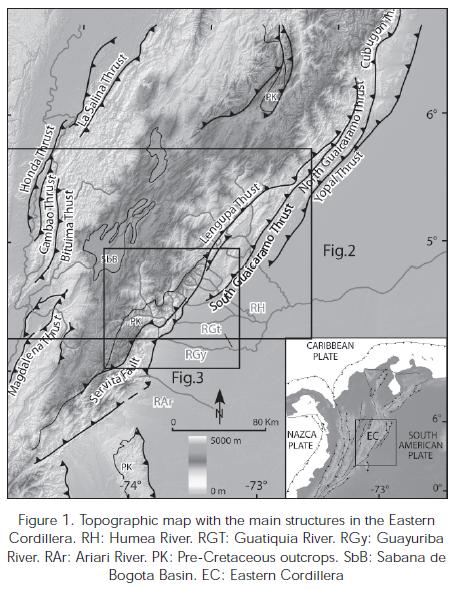
Another interesting aspect in the Eastern Cordillera is its bivergent configuration (Figure 2), with two marginal basement highs, bounded by thick skinned faults and adjacent synclines with thick Tertiary and Quaternary records (e.g. Mora et al., 2008). These structural domains probably characterize the most important across strike tectonic provinces of the Eastern Cordillera with analogues always present along strike. For instance, along the Eastern Foothills there is always a fault that uplifts the basement, exposes basement to Lower Cretaceous rocks in its hanging wall and creates the highest relief adjacent to a deformation belt to the east where relief is lower and normally faults have shallowly dipping angles. The hanging wall areas of these shallowly dipping faults are frequently constituted by synclines where a more than 3 km thick Tertiary to Quaternary sequence is preserved. This is true for the Tesalia fault and adjacent southern Guaicaramo thrust but also for the northern Guaicaramo fault and adjacent Yopal and Cusiana thrusts (Figure 1). This pattern is also present along the Middle Magdalena side of the Eastern Cordillera. An interesting question is, if it has something to do with the former rift basin and if the similar geometries observed along strike are also related with analogue timings of deformation.
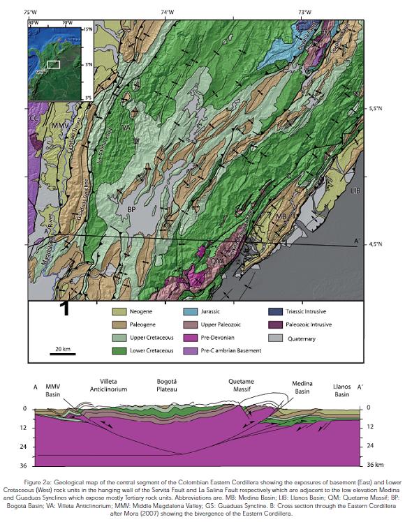
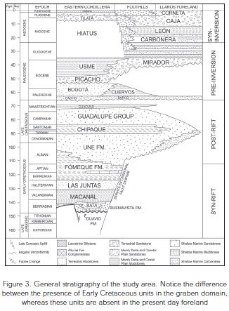
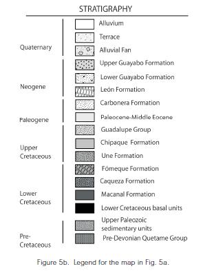
The southern Eastern Foothills of the Eastern Cordillera are characterized by the exposure of all the rock units recording the pre-rift phase and also the syn-rift and syn-inversion strata (Figures 1, 2 and 3). However, pre rift outcropping units are not always the same in the southern eastern foothills. The sedimentary units of the Upper Paleozoic Farallones Group (Ulloa & Rodríguez, 1979) is sometimes below the syn-rift Buenavista (Dorado, 1984) and Macanal formations (Ulloa & Rodríguez, 1979) of Lower Cretaceous age (Figure 3). In other areas, is the metasediments of the pre-Devonian Quetame Group (Renzoni, 1968), the underlying unit. Mora et al. (2006) and Mora (2007) documented that this is mostly due to erosion prior to the onset of Cretaceous deposition, controlled by extensional tectonics, mostly footwall uplift. In this paper our studies are focused in the region between the Guatiquia and the Ariari rivers (Figures 1, 4 and 5 for locations) in the southern portion of the Quetame Massif with the aim of documenting the presence of footwall shortcuts. Although most of this region is characterized by uninhabitated steep mountains with thick jungles, the deep canyons of the main rivers provide good exposures of the main structural relationships that were difficult to visit for long times due to these geographic conditions and formerly due to security problems too. We will show that the presence of privileged field and subsurface relationships together with thermal and thermochronological data allow us to support this as the only area of the Eastern Cordillera were footwall shortcuts has been unambiguously documented so far.
Geology of the Ariari-Guatiquia region
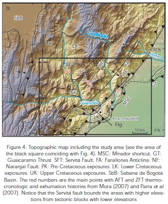
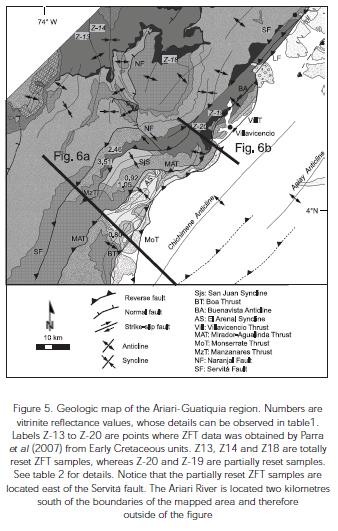
The Ariari-Guatiquia region (Figures 4 and 5) is characterized by the presence of basement involved faults whose main features were mapped in detail during our field work. The westernmost fault is the Servitá fault, which is a rectilinear feature followed from the densely wooded headwaters of the Guamal and Agualinda rivers in the southern extreme of the study area to the Guatiquia River (Figure 4). The Servitá fault can be defined as the fault bounding the area where the Upper Paleozoic sedimentary units of the Farallones Group underlie Cretaceous units in the more frontal eastern foothills between the Ariari and Guatiquia rivers (Figure 5). Interestingly when mapping the described contact it is realized that the hanging wall areas constitute regions of higher topographic elevation compared with the lower elevation footwall areas (Figure 4). The most important reliefs are therefore generated by this feature in this region.
The Manzanares thrust (Figure 5) is a much shorter feature identified near the Manzanares River which puts the Macanal formation in its hanging wall against rocks of the Chipaque formation. Importantly in its hangingwall there are no more Upper Paleozoic rocks below the lowermost Cretaceous units. The lowermost Cretaceous units in the northern portion of the Manzanares fault is constituted by the Macanal and Buenavista formations which progressively pinches out southwards until a basal sandstone unit, pressumably the Une formation, overlies the metamorphic units of the Quetame Group.
Farther east the Mirador-Agualinda fault (Figure 5) shows a similar pattern compared with the Manzanares fault. In the northern portion of the hanging wall of this fault, sandy units of the Une formation overlie a continuous black shale unit (Macanal Formation) lying above the basal Buenavista Formation breccias. A progressive pinchout of the Macanal and Buenavista formations is traduced southwards in the exposure of the Une formation above the pre- Devonian metasedimentary units of the Quetame Group. In its footwall there are unique exposures of condensed Cretaceous sequences which have been palynologically dated when the study area was part of the Rio Blanco exploratory block of Chevron Petroleum Company during the nineties of the last century. Therefore the ca. 300m thick Une formation is again overlying the Quetame group and on top of it a there is a much thinner Upper Cretaceous sequence, in comparison with the sequence outcropping west of the Servitá fault. This sequence consists of less than 200m of the shaly Chipaque formation and less than 300m of the sandy Guadalupe group. Following the palynological determinations of Chevron, the Late Eocene Mirador formation directly overlies the Guadalupe Group, therefore the Paleocene Barco and Cuervos formations are missing. The lithologies outcropping in the footwall of the Agualinda fault and recognized by the first author working for Chevron at that time coincide with that expected from the chronology inferred from the palynostratigraphy. This area is bounded to the east by the Boa fault (Figure 5). In turn east of the Boa fault the tectonically active Monserrate fault splays from the Boa thrust.
Interestingly, the hanging wall of the Boa and Agualinda thrust has a similar stratigraphic succession compared to the wells in the adjacent foreland, where Lower Cretaceous units are absent. In contrast, Lower Cretaceous units are always present west of the Servitá fault with thicknesses of up to 3 km (Figure 6a).

From the above observations it can be concluded that there is an abnormally high variability of lithologies and thicknesses in the region bounded by the Boa and the Servitá faults. Furthermore those lithologies are different from the pre-Cretaceous, Cretaceous and Tertiary units exposed east of the Servitá fault.
Structural styles of the Ariari-Guatiquia region
The rectilinear trace of the Servitá fault suggests a high angle (>45°) fault (Figures 4 and Figure 5). The presence of cataclastic zones with higher erodability than the adjacent intact rocks suggests a very active fault but also prompts that the trace of the fault defines a marked lineament which is normally topographycally deeper than the adjacent hanging wall and footwall areas. The Servitá fault is segmented in two different rectilinear traces by the Naranjal traverse fault (Figures 4 and Figure 5). However, farther east its dextral displacement is absorved by folding of the fault traces of the Manzanares, Agualinda, Mirador, Boa and Monserrate faults. Mora et al. (2006) and Mora (2007) proposed that the rectilinear northern trace of the Servitá fault and the obliquity of fold traces in its hanging wall close to the Guatiquia river suggest a dextral lateral component of movement along the Servitá fault (Figure 5).
In contrast with the Servitá fault, from the data obtained by the Anaconda-1 wildcat- well it has been demonstrated that the frontal Villavicencio and Mirador thrusts should have a lower dip angle compared to the Servitá fault (Figure 6b). The well drilled the basement but downwards found the Tertiary Carbonera formation again. In order to preserve consistency in shortening values it can be expected that the southern equivalent segments of these thrusts, namely the Agualinda and Boa thrusts should have a similar dip compared with the Mirador and Villavicencio thrusts. In fact seismic lines show what can be interpreted as a shallowly dipping fault trace. Furthermore the anastomosed pattern of surface fault traces suggests the plan view of thrust faults rather than high angle reverse faults (Figure 5). This is therefore a strong contrast with the Servitá fault inferred dip. In addition overturned forelimbs characterize the hanging wall of the frontal thrusts like the Boa and Monserrate thrusts.
Interestingly the Boa Anticline fold trace is truncated at its northern termination by the Boa Thrust (Figure 5). Equally the Arenal Syncline's northern termination is almost perpendicularly truncated by the Agualinda thrust. In addition seismic lines and the surface fault traces of the northern segment of the Mirador thrust, sub-parallel to the Macanal-Une formational contact, suggest that a fault cutting sequence stratigraphically up cuts and already overturned forelimb of the Buenavista Anticline (Figure 5). The exposed relationships suggest that folding precedes faulting and therefore it is likely that folds initially formed as fault propagation folds were cut later by out of sequence emergent thursts.
Thermal maturity data from the Guatiquia-Ariari region
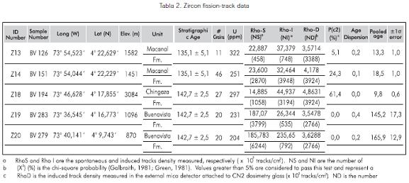
Vitrinite reflectance from coal seams has been performed in the study area. The data from the basal Une formation sandstones of the San Juan syncline and the Boa anticline shows Ro values between 0,6 and 1(samples Boa-46, Boa-93, LS-129, FA-05 and CC-02 in Table 1, see also Figure 5). This is in stark contrast with those values from the basal sandstones of the hangingwall of the Manzanares thrust, with values around 2,5 and 3,5 (samples Manz-29C and Manz 29B in Table 1, see also Figure 5). In addition Zircon fission track data was used in this work to have a rough idea of the maximum paleotemperatures reached by the basal Cretaceous rocks west of the Servitá fault. Samples from the Buenavista formation do not group around coherent statistical populations, therefore the Chi2 test of age populations fails (failing = < 5%) but furthermore have ages around the stratigraphic age of the unit (samples Z19 and Z20 in Table 2, see location in Figure 5). The data together shows that the southern segment of the structural domain west of the Servitá fault never reached maximum paleotemperatures higher than the closure temperature of the Zircon fission track system (ca. 280°C / 553,15 K) but even more in the segment south of the Naranjal fault and east of the Manzanares fault, where the Une formation is the basal Cretaceous unit, the maximum paleotemperatures reached were lower than 150°C (423,15 K), based on the Ro data.
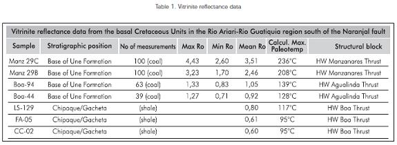
This shows a marked contrast with the situation west of the servitá fault. Parra, Mora, Jaramillo, Strecker, and Sobel (2007) demonstrated that the lowermost Cretaceous units reached maximum paleotemperatures higher than the closure temperature of the Zircon fission tracks systems (ca. 280°C; 553,15 K). This is supported by Ro data showing values higher than 4 in the Lower Cretaceous Macanal formation (Mora, 2007). Therefore it appears that the Servitá fault constitutes a very clear boundary for different thermal histories at each side of the fault. Lower Cretaceous rock units to the east never reached temperatures higher than 280°C (553,15 K) whereas equivalent rocks to the west clearly reached temperatures higher. The hanging wall block of the Manzanares thrust constitutes a transition zone with maximum paleotemperature values higher than those of the Boa and Agualinda hanging walls but lower than the Zircon closure temperature.
Timing of deformation
Thermochronology is a discipline that includes a variety of techniques which try to give absolute timing to the presence of a given mineral species or rock unit inside a certain temperature range. It can be very helpful in assessing the timing of deformation if other geological factors (surface elevation, rock uplift rates) can be established. If this is true, the movement of the rock units through different isotherms can be converted into deformation rates. Apatite Fission Track Analysis (AFT) can be used to assess when rock units passed through temperatures close to 120°C (153,15 K ) and Zircon Fission Track data through 280°C (553,15 K). If mineral species from the rock units now exposed or analyzed never passed through the respective isotherm they are referred to as partially reset.
The youngest part of the denudation history of the hanging wall of the Servitá fault is described in Mora (2007) by means of Apatite Fission Track data (AFT). Mora (2007) found Plio-pleistocene AFT cooling ages. However, as mentioned before, rock units in the hanging wall of the Servitá fault reached maximum paleotemperatures much higher than AFT closure temperatures (~120°C; 153,15 K), and even Lower Cretaceous rocks reached temperatures higherthan Zircon Fission Tracks (ZFT) closure temperatures (~250°C; 23,15 K). Therefore exhumation ZFT ages in those rocks should be closer to the onset of exhumation. Parra et al. (2007) reported Late Oligocene-Early Miocene ZFT ages in the hanging wall block of the Servitá fault, even in samples where Mora et al, (2008) performed AFT analysis (Table. 2). The Servitá fault movement should be therefore older than Early Miocene.
In contrast, based on AFT data as well, Mora (2007) documented that the structures east of the Servita block should not be older than 4 Ma. Mora (2007) compared the thickness of the sedimentary section east of the Mirador fault with the burial that is needed to reach AFT closure temperatures (Figure 6b). He found both values similar. With AFT ages close to 3 Ma at the base of the Buenavista Formation, the tectonic transport from peak burial temperatures to the surface should have occurred in ca. 4 Ma. In addition, Mora et al. (2007) showed that the uppermost unit reaching the AFT closure temperature in the hanging wall of the Boa and Agualinda faults south of the Naranjal fault is the Une Formation. Therefore its AFT age should be a proxy of the age of the thrusts. Mora (2007) obtained values close to 4 Ma (Figure 6a).
It can be concluded that the timing of deformation at each side of the Servita fault is also very different. A Late Oligocene-Early Miocene onset of tectonically induced denudation, and associated deformation contrasts with a Late Miocene age for the denudation associated with movement along the thrusts east of the Servitá Fault (eg. Agualinda, Mirador and Boa thrusts).
DISCUSSION AND CONCLUSIONS
From many lines of evidence it can be confirmed what was already proposed by Mora et al. (2006). The Servitá fault is the expression of the first well documented precise location of a master fault of the Lower Cretaceous graben in the Eastern Cordillera. Different rock units at each side and different degrees of erosion previous to the onset of Cretaceous deposition are the most evident data supporting that interpretation. In addition, the thermal histories and different amounts of Meso-Cenozoic burial at each side of the Servitá fault confirm this hypothesis. The following point is if the faults east of the Servitá fault are reactivated minor normal faults or footwall-edge shortcuts.
The Manzanares thrust exposes at its southern termination basal Cretaceous sandstones that haven't been dated yet and the thickness of the exposed units is difficult to establish with the available data. However, the vitrinite data collected in the lowermost Cretaceous units in its hanging wall areas shows Ro values significantly higher than the values in the lowermost Cretaceous units few kilometres to the east in the hanging wall of the Agualinda and Boa thrusts. This can be interpreted as different amounts of total removed burial at each side of the Manzanares fault or different thermal histories. In either of both cases the fault appears to be the boundary. Therefore we propose that this behaviour should indicate a bigger likelihood of the Manzanares fault being a reactivated normal fault adjacent to the master graben fault at this latitude.
A different behaviour is observed in the case of the Agualinda and Boa thrusts. Both of them share similar Ro values and the sequence of Cretaceous and Tertiary units is similar to that in adjacent areas in the Chichimene, Castilla or Apiay oil fields (Figures 5 and 6a). In addition the fact that the Une formation was the uppermost unit passing total closure temperatures of apatite fission tracks (ca. 130°C; 403,15 K) shows that the burial above the Cretaceous Une formation was similar to the burial that this unit reached in the adjacent Llanos foreland in the Apiay and Chichimene oil fields. If we take into account the low angle of the Boa and Monserrate thrusts, we propose that in this case it more likely that the Agualinda and Boa thrusts uplift pieces of the stratigraphy of the adjacent Llanos foreland and are not reactivated Lower Cretaceous normal faults. Therefore they should be footwall shortcuts.
Northwards, the Mirador and Villavicencio thrusts expose in their hanging walls, rock units that have different ages, thicknesses and facies compared with the units to the west in the hanging wall of the Servitá fault. However, those units are also different from those in the footwall of the Villavicencio thrust too, in the adjacent foreland (Figure 6a). The Pliocene timing of deformation is also different in the hanging wall of the Mirador and Villavicencio thrusts compared with the Late Oligocene Early Miocene onset of movement of the Servitá fault hanging wall. Based on its peculiar stratigraphic features, the Villavicencio thrust could be interpreted as a former normal fault outside the main graben domain and east of the master fault; therefore a structure transitional between the Lower Cretaceous graben and the undeformed foreland. However, the along strike continuity with unambiguous footwall shortcuts like the Agualinda and Boa thrusts and the shallow dip of the Villavicencio thrust favors that the block uplifting the Buenavista anticline is part of a footwall shortcut.
If the timing of deformation is compared with the geometry and character of the structures it can be deduced a straightforward relationship. The master inversion normal fault in the Ariari-Guatiquia region is the Servitá fault. In contraction is a fault that is reactivated earlier than any kind of new footwall structures develop. It is therefore active since the Oligocene at least. It focuses deformation during the Miocene in the Ariari-Guatiquia region, until it is transferred to the gently dipping structures during the Pliocene. These gently dipping structures are footwall shortcuts. Thus, in this precise case, there is a direct coincidence between older faults and inverted master faults and younger faults with footwall shortcuts. Another important feature is the fact that the higher angle master inversion fault (the Servitá fault) generates the main topographic relief and the stronger relief contrast with adjacent shortcuts.
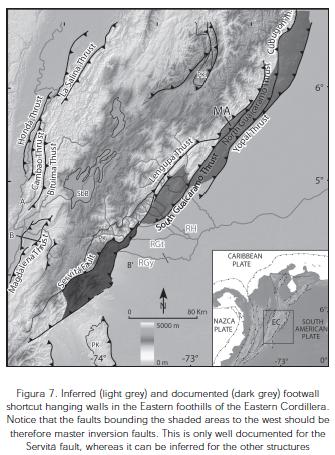
Based on the previous observations we propose that the Ariari-Guatiquia region can be used as a type location along the eastern foothills and even in the Eastern Cordillera, for the relationships between master inversion faults and adjacent footwall shortcuts. We therefore suggest that faults that uplift the basement, exposes basement to Lower Cretaceous rocks in its hanging wall and create the highest relief adjacent to a deformation belt to the east (where relief is lower and normally faults have shallowly dipping angles) could correspond to the master basin boundary faults of the Neocomian rift (Figure 7). This point of view is reinforced by the fact that these faults have a well documented activity since the Oligocene in the eastern foothills (eg. Mora 2007). This is true for the northern segment of the Guaicaramo fault, north of the Medina area, and northwards the Los Yopos and Cubugon faults along the eastern foothills (Figure 7). In addition, a change in the thermal regime analogue to that observed east of the Servitá fault is observed in the footwall of the Los Yopos fault, more precisely in the Monterralo anticline (Mora 2008, see location in Figure 7), and is also observed east of the Cubugon fault (internal report). Therefore the Los Yopos, Northern Guaicaramo and Cubugon faults could actually correspond to graben boundary faults. It could be possible too, that the adjacent synclines, where a more than 3 km thick Tertiary to Quaternary sequence is preserved, are bounded by footwall shortcuts (Figure 7). This point is reinforced by the fact that those faults were mostly active from the Late Miocene to the present, like the documented shortcuts (Mora, 2008). The pattern of an inferred "en echelon" disposition (Figure 7) could be therefore related with the configuration of the boundary of the Neocomian graben domain.
If our hypothesis is true, then the timing of inversion should not involve that the relief created by inversion originated later (out of sequence) with respect to the forelandward growing adjacent low angle faults as was initially believed (Martínez, 2006). Instead the earlier inversion of the master normal faults should at some point push the low angle faults as an in sequence forelandward migration of deformation. In turn this sequence of deformation probably discards inversion faults with very deep detachments (>30 km) as proposed in previous models. In fact shallower detachments (depths of ~20-25 km) are more in line with area balance calculations (Colleta et al., 1990; Corte, Colletta, & Angelier 2006; Mora, 2007) and seismicity (Mora et al., 2006).
In the Ariari-Guatiquia area folding of the footwall- edge-shortcuts precedes faulting during the main shortening event, as demonstrated by cross cutting relations. In terms of hydrocarbon systems this relationships may indicate that low amplitude structures were present before the main exhumation episodes occurred. Therefore the chance of being charged by older migration events is bigger in this case. In fact, northwards, close to the Cusiana oil field, Martínez (2006) documents and interesting behaviour in structures that following our interpretation would be footwall shortcuts. This behaviour is, pre-Miocene low amplitude folding previous to the main Pliocene faulting and deformation episode. If this apparently positive timing relationships are common along the eastern foothills, prospectivity should be increased. However, more data on the precise timing of the processes in the petroleum systems is needed in order to build robust models to test such hypothesis.
ACKNOWLEDGMENTS
The authors are indebted to the two anonymous reviewers whose careful observations and suggestions on this manuscript helped improving the contents, ideas and figures that are shown here. Equally we are grateful with the editors of CT&F for allowing us to put this paper under their consideration.
REFERENCES
Allmendinger, R.W., Jordan, T. E., Kay, S. M., & Isacks, B. L. (1997). The evolution of the Altiplano-Puna Plateau of the Central Andes. Annual Review of Earth and Planetary Sciences, 25: 139-174. [ Links ]
Baby P., Moretti, I., Gullier, B., Oller, J., Limachi, R., & Specht, M. (1995). Petroleum System of the Northern and Central Bolivian Sub-Andean Zone. In: A.J. Tankard, R. Suarez and H.J. Welsink (Editors), Petroleum basins of South America. AAPG, 445 - 458. [ Links ]
Colleta, B., Hebrard, F., Letouzey, J., Werner, P., & Rudkiweicz, J. L. (1990). Tectonic style and crustal structure of the Eastern Cordillera. Colombia from a balanced cross section, in Letouzey, J., ed., Petroleum and Tectonics in Mobile Belts. Paris, Editions Technip, 81-100. [ Links ]
Cooper, M. A., & Williams, G. D. (1989). Inversion Tectonics. Geological Society Special Publication, 44: 375
Cooper, M. A., Addison, F. T., Álvarez, R., Coral, M., R. H., G., Hayward, S. H., Martínez, J., Naar, J., Peñas, R., Pulham, A. J., & Taborda, A. (1995). Basin development and tectonic history of the Llanos Basin, Eastern and Middle Magdalena Valley, Colombia. American Association of Petroleum Geologists Bulletin, 79 (10), 1421-1423. [ Links ]
Cortes, M., Colletta, B., & Angelier., J. (2006). Structure and tectonics of the central segment of the Eastern Cordillera of Colombia. Journal of South American Earth Sciences. 21 (4), 437-465. [ Links ]
Coward, M. P., Enfield, M. A., & Fischer, M. W. (1989) Devonian Basins of Northern Scotland: extension and inversion related to Late Caledonian -Varisican tectonics. In: Inversion Tectonics (Ed. by M. A. Cooper & G. D. Williams), Geological Society Special Publication, 44: 275-308. [ Links ]
Dorado, J. (1984). Contribución al conocimiento de la estratigrafía de la Formación Brecha de Buenavista (límite Jurásico-Cretácico, oeste de Villavicencio, Meta. Unpublished Bsc thesis work, Universidad Nacional de Colombia, Bogotá, Colombia. [ Links ]
Dunn, J., Hartshorn, K., & Hartshorn, P. (1995). Structural styles and hydrocarbon potential of the Sub Andean Thrust belt of southern Bolivia. In: A. J. Tankard, S. R. Suarez & H. J. Welsink (Editors), Petroleum basins of South America. American Association of Petroleum Geologist, Tulsa, Oklahoma, 523 - 543. [ Links ]
Echavarría, L., Hernández, R., Allmendinger, R., & Reynolds, J. (2003). Subandean thrust and fold belt of northwestern Argentina: geometry and timing of the Andean evolution. AAPG Bulletin, 87(6), 965-985. [ Links ]
Gil, W., Baby, P., & Ballard, J. F. (2001). Structure and palaeogeographic control of the Peruvian Subandean zone. Comptes Rendue de l'Académie de Sciences Series IIA Earth and Planetary Science, 333(11), 741-748. [ Links ]
Hayward, A. B., & Graham, R. H. (1989). Some geometrical characteristics of inversion. In: Inversion Tectonics (Ed. by M. A. Cooper & G. D. Williams), Geological Society Special Publication, 44: 17-39. [ Links ]
Hetzel, R., & Strecker, M. R. (1994). Late Mozambique Belt structures in western Kenya and their influence on the evolution of the Cenozoic Kenya Rift. J. Struct. Geol., 16: 189-201 [ Links ]
Hilley, G. E., Blisniuk, P. M., & Strecker, M. R. (2005). Mechanics and erosion of basement-cored uplift provinces: Journal of Geophysical Research B: Solid Earth. 110 (12), 1-22. [ Links ]
Huyghe, P., & Mugnier, J. L. (1992a).- Short-cut Geometry during structural inversions : competition between faulting and reactivation. Bull. Soc. Geol. Fr., 6 (163), 691-700. [ Links ]
Huyghe, P., & Mugnier, J. L. (1992b).- The influence of depth on reactivation in normal faulting. J. Struct. Geol., 14 (8/9), 991-998. [ Links ]
Huyghe, P., & Mugnier, J. L. (1995) A comparison of inverted basins of the southern North Sea and inverted structures of the external Alps. In: Basin Inversion (Ed. by J. G. Buchanan & P. G. Buchanan), Geological Society Special Publication, 88: 339-353. [ Links ]
Kammer, A., & Sánchez J., (2006). Early Jurassic rift structures associated with the Soapaga and Boyacá faults of the Eastern Cordillera, Colombia: Sedimentological inferences and regional implications. Journal of South American Earth Sciences, 21 (4), 412-422. [ Links ]
Kley, J., Monaldi, C. R., & Salfity, J. A. (1999). Along-strike segmentation of the Andean foreland: causes and consequences. Tectonophysics, 301(1-2), 75-94. [ Links ]
Kley, J., & Monaldi, C. R. (2002). Tectonic inversion in the Santa Barbara System of the central Andean foreland thrust belt, northwestern Argentina. Tectonics, 21: 11-1. [ Links ]
Lowell, J. D. (1995) Mechanics of basin invesion from wolrdwide examples. In: Basin Inversion (Ed. by J. G. Buchanan & P. G. Buchanan), 339-353. Geological Society of London Special Publication, 88. [ Links ]
Martínez, J., (2006). Structural evolution of the Llanos foothills, Eastern Cordillera, Colombia. Journal of South American Earth Sciences, 21 (4), 510-520. [ Links ]
McClay, K. R. (1995). The geometries and kinematics of inverted fault systems: a review of analogue model studies. In: Basin Inversion (Ed. by J. G. Buchanan & P. G. Buchanan), Geological Society Special Publication, 88: 97-118. [ Links ]
Mitra, S. (1993). Geometry and kinematic evolution of inversion structures: American Association of Petroleum Geologists Bulletin, 77 ( 7),1159-1191. [ Links ]
Mora, A., Parra, M., Strecker, M. R., Kammer, A., Dimaté, C., & Rodríguez, F. (2006). Cenozoic contractional reactivation of Mesozoic extensional structures in the Eastern Cordillera of Colombia. Tectonics, 25. TC2010, doi: 10.1029/ 2005TC001854. [ Links ]
Mora, A. (2007), Inversion tectonics and exhumation processes in the Eastern Cordillera of Colombia. Ph. D. Thesis, Universität Potsdam, 133 pp. [ Links ]
Mora, A., (2008). Edades de trazas de fision en Zircones y Apatitos de la Cordillera Oriental y su significado geológico. Reporte final, Ecopetrol S.A.-Instituto Colombiano del Petroleo (ICP). [ Links ]
Mora, A., Parra, M. Strecker, M. R., Sobel, E. R., Hooghiemstra, H., Torres, V., & Vallejo-Jaramillo, J., (2008). Climatic forcing of asymmetric orogenic evolution in the Eastern Cordillera of Colombia. Bulletin of the Geological Society of America, 120 (7). doi: 10.1130/B26186.1 [ Links ]
Parra, M., Mora, A., Jaramillo, C., Strecker, M. R., & Sobel, E. R. (2007). Cenozoic exhumation history in the northeastern Andes: evidence from low-T thermochronology and basin analysis in the Eastern Cordillera of Colombia, in VI EGU General Assembly, Vienna, Austria. [ Links ]
Paton, D. A. & Underhill, J. R. (2004). Role of crustal anisotropy in modifying the structural and sedimentological evolution of extensional basins: The Gamtoos Basin, South Africa. Basin Research, 16: 339-359. [ Links ]
Renzoni, G. (1968). Geología del Macizo de Quetame. Geología Colombiana, 5: 75-127. [ Links ]
Ring, U. (1994). The influence of preexisting structure on the evolution of the Cenozoic Malawi rift (East African rift system), Tectonics, 13(2), 313-326. [ Links ]
Ulloa, C., & Rodríguez, E. (1979). Geología del Cuadrángulo K-12 (Guateque). Boletín Geológico del Ingeominas, XXII, 1: 5-55. [ Links ]
Underhill, J. R. & Paterson, S. (1998). Genesis of tectonic inversion structures: Seismic evidence for the development of key structures along the Purbeck-Isle of Wight Disturbance. Journal of the Geological Society, 155: 975-992. [ Links ]
Yamada, Y., & McClay, K. R. (2004) Analog modeling of inversion thrust structures: Experiments of 3D inversion structures above listric fault systems. In: Thrust Tectonics and Petroleum Systems (Ed. by K. R. McClay), American Association of Petroleum Geologists Memoir, 82: 276-302. [ Links ]

