


 text in
  English (pdf)
 Article in xml format
 Article references
 Send this article by e-mail
 Cited by SciELO
  Cited by Google
  Similars in
SciELO
Similars in
SciELO  Similars in Google
 Permalink
Introduction
In 2011, the Information and Communication Network of the Colombian Agricultural Sector (Agronet) (2016) reported that in the department of Tolima (Colombia), 2,853 ha of Tahiti lime had been harvested with a production of 60,508 t and an average yield of 28 t/ha. A couple of years later in 2013, given the climatic and sanitary conditions, these values decreased strongly, and the reported production area was only 300 ha, with a total production of 4,500 t and a yield of 15 t/ha (Agronet, 2016). The decrease in Tahiti lime production after 2011 reached 63 % and occurred due to a physiopathy that the Colombian Agricultural Institute (ICA) diagnosed as wood pocket, based only on theoretical references that alluded to similar symptoms, since this problem had never been reported in Colombia before.
In 1957, Knorr described this physiopathy in Florida. In 1928, Fawcett and Calavan reported the wood pocket physiopathy in Riverside (California, U.S.A.) in 10-year-old Lisbon lemon trees. During this decade, this physiopathy destroyed the Tahiti lime industry in Florida, and its appearance in Mexico (the world's leading producer) showed the seriousness of the problem, as in a short period, the market profitability of fruits and processed products decreased drastically (Almeyda-León et al., 2002; Calavan, 1957; Fawcett & Calavan, 1948; Knorr, Suit, & DuCharme, 1957).
Wood pocket is considered to be genetically inherent to most Persian, Bearss or Tahiti limes. It is a serious problem, which has been recognized only in some producing regions of the world, such as Saudi Arabia, Belize, Egypt, the United States, Mexico and the Sultanate of Oman (Almeyda -León et al., 2002; Garnier, Zreik, & Bové, 1991; Knorr et al., 1957). It has been found to be especially severe in hot, dry climates with high temperatures (Calavan, 1957).
Initial studies regarding the appearance of wood pocket in the United States indicate that the physiopathy is transmitted only by grafting, when using scions of Tahiti lime plants with this genetic condition (Colburn & Goldweber, 1971). Their management strategy consisted of using resistant rootstocks, and the materials used in the United States were also evaluated in countries such as Saudi Arabia and Oman, where they were susceptible (Roistacher, 2001).
It is necessary to mention that in the conditions of the department of Tolima the symptoms were similar to those reported in the literature for wood pocket (Klotz, Calavan, & Weathers, 1972), associated with a severe condition of dry hot climates and high temperatures (Calavan, 1957). However, there is not enough evidence to recognize wood pocket in the area. Likewise, no analysis of the rootstocks of the affected study area has yet been carried out.
The pathological diagnosis that the Corporación Colombiana de Investigación Agropecuaria (AGROSAVIA, formerly Corpoica) carried out in 2012 ruled out that the damage was promoted by pathogens, from which it is inferred that it is a physiopathy. Therefore, from this point onwards, we will not call this problem wood pocket but a physiopathy.
According to García de Pedraza (1982), damage to plants and crops caused by abiotic origin agents is often called a physiopathy, and the effects of atmospheric phenomena, such as high or low temperatures, hail, frost, heat stroke, torrential rains and drought are highlighted, among others.
Poor management of the hydration system of the crop can enhance the physiopathy, and in 2010, Agrosavia proved the occurrence of this situation in orchards of the department of Tolima. In addition, in the Tahiti lime-producing zone in this department, the tropical dry climate condition is widespread according to the classification of Holdridge (1967).
Similarly, the climate analysis carried out by Instituto de Hidrología, Meteorología y Estudios Ambientales (Ideam, 2005) for year 2005, shows that in the study area the average monthly temperature ranged from 24 °C to 29 °C, and that the annual evapotranspiration exceeded precipitation by 34 %.
Additionally, the periods of rainfall deficit range from seven to eight months, and in very dry years, such as 2015, the anomaly may occur throughout the year.
This severe climatic situation, the presence of the physiopathy in the area and the identification of a system sensitive to water deficit, suggests that the ecosystem and the water management may enhance the death of trees caused by the disease.
Taking into account that the environment, influences plant growth and development especially by water availability (Vélez, Álvarez-Herrera, & Alvarado-Sanabria, 2012), the magnitude of the water deficit of the area might have affected the "health" of the Tahiti lime orchards.
The above mentioned is due to root development limitation (Melgar, Dunlop, & Syvertsen, 2010, Rodríguez-Gamir, Primo-Millo, Forner, & Forner-Giner, 2010) and an increase in demand due to the start in production; with these conditions, the plant is incapable of maintaining water flow, and the excess effort to capture the water from the ground causes the vascular system to collapse by cavitation. With collapsed and fractured tracheids, the plant cannot continue to carry water and nutrients massively to the aerial part, causing its death.
In this regard, Pérez-Pérez, García, Robles and Botía (2010) mention that in climates where plants suffer stress due to water deficit, leaves show wilting due to a reduction of leaf water potential, a reduction of stomatal conductance, low rates of CO2 assimilation, and hydraulic conductivity of the root, that jointly lead to the death of the tree.
Nonetheless, it is necessary that future studies demonstrate if the necrosis observed in the wood of the plants from Tolima, that have been affected by the physiopathy, is due to ruptures of vascular tissue that collapses because of cavitation, and this in turn is caused by water deficit.
In 2012, when AGROSAVIA detected the physiopathy, an investigation with the purpose of assessing its real coverage was carried out, finding symptoms in all the farms visited that spread over six municipalities in four-year-old orchards, i.e. with a lower age than what had been reported in the literature (Roistacher, 2001).
The region features tropical dry climate characteristics with an average annual temperature of 27.5 °C and an environmental supply characterized by a negative water balance (precipitation-evapotranspiration), which occurs from six to nine months per year. Soils have high drainage conditions formed by volcanic origin materials (i.e. activity of Cerro Machín) and by fluvial dynamics of the Magdalena River and its tributaries (Corporación Autónoma Regional del Tolima [Cortolima], 2006), Instituto Nacional de Investigaciones Geológico-Mineras [Ingeominas], 1998). The aforementioned conditions are ideal for the stimulation of a hydric stress physiopathy.
Moreover, soils in the region are characterized by having an average infiltration rate of 17.46 mm/hour, which is rated as moderate to rapid, favoring drainage processes, and with a water storage capacity rated as low and very low.
Considering these two hydrodynamic soil properties, irrigation systems with high flow rates such as gravity and sprinkling, are not recommended. Nonetheless, high frequencies over short periods are preferred, with micro-sprinkling or dripping systems, in order to reduce considerable losses through deep percolation.
In the orchards of the department of Tolima, the physiopathy expressed differentially, implying the need to identify the climatic and hydrophysical soil characteristics of the producing zone. This will allow establishing the factors that benefit or enhance the development of the physiopathy associated to local conditions and be able to elaborate management recommendations in affected areas, including prevention strategies for unaffected areas.
Materials and methods
Study area
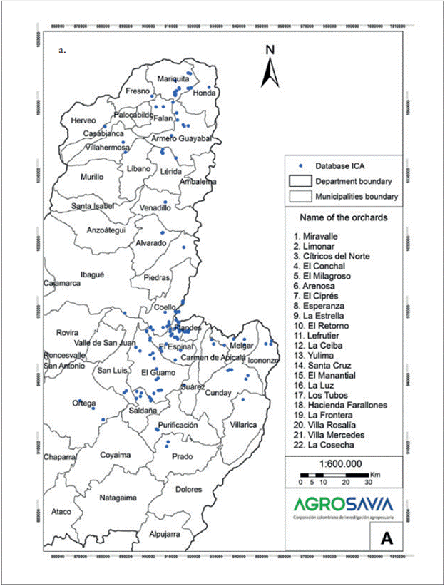
The study area includes the parts of the department of Tolima, Colombia, where Asociación de Productores del Limón del Valle del Magdalena (Yuma) [Association of Lemon Producers of the Magdalena Valley (Yuma)] has reported the existence of the crop. The database consulted for the location of farms, which is updated up to 2016, belongs to ICA; this database is unpublished, and was obtained through personal communication with Mrs. Matilde Antía, who was the legal representative of Yuma in 2016.
The producing area of Tahiti lime in Tolima is framed in the following plane coordinates with Magna-Sirgas projection: Xmax 960300 - Ymax 1080500; Xmin 840000 - Ymin 890000, covering part of the Magdalena Valley in the north-central part of the department.
The information in the database was cleaned to establish correct georeference data for study locations, the presence of the crop and the incidence of the physiopathy. To this end, field visits to farms as well as telephone calls to owners were carried out, including interviews with relevant question. Filtering was continued by economic criteria and the effect of the physiopathy, and thus, the farms in which the crop occupied an area equal to, or larger than one hectare were selected, since this is considered the minimum profitable family area for Tahiti lime (Tafur, Toro, Perfetti, Ruiz, & Morales, 2006). In addition, the orchards of more than two years of age were included. Younger orchards were not included, as these did not show the effects of the physiopathy.
Plant material
According to field visits and interviews made to the producers assessed, Tahiti lime cultivation uses the Volkameriano rootstocks in all farms; however, they also use Carrizo, CPB, Troyer and Sunky rootstocks in smaller proportion. This information allows deducing that the rootstock should not have an incidence in the physiopathy, since there is no common pattern.
However, producers do not have a record of the genetic identity of the rootstock, nor a georeferenced history of planting and replanting. Thus, this demonstrates the need to conduct a study of the genetic identity of the patterns in the affected orchards, to corroborate the effect of this factor.
Climate information
The set of climate information was consulted in the high resolution WorldClim database (Hijmans, Cameron, Parra, Jones, & Jarvis, 2005), a global geodatabase of monthly averages, based on a large number of observations on precipitation and maximum, mean and minimum temperatures from the period between years 1950 and 2000. Furthermore, the topographic data was obtained from the Shuttle Topography Radar Mission (STRM).
In Colombia, WorldClim was structured by the International Center for Tropical Agriculture (CIAT). The spatial resolution used is 30 seconds of arc, equivalent to ca. 0.86 km2 in the Equator, and is particularly robust in Latin America, since it includes average monthly precipitation data of 18,895 stations, average temperature values of 13,842 stations, and minimum and maximum temperature values of 5,321 stations (Hijmans et al., 2005).
WorldClim has been widely used because of its data quality and easy acquisition. Further, Zomer, Bossio, Trabucco, Yuanjie, Gupta and Singh (2007) and Zomer, Trabucco, Bossio and Verchot (2008) validated it, applying the Hargreaves method to generate a global potential evapotranspiration map (Global-PET). These results allowed Henríquez-Dole and Miner-Vega (2014) to affirm that the database is reliable.
This tool has been used in studies on the effect of climate change on crop systems (Evangelista, Young, & Burnett, 2013, Läderach, Martinez-Valle, Schroth, & Castro, 2013, Schroth, Läderach, Cuero, Neilson, & Bunn, 2015), soil moisture (Topete-Ángel et al., 2014), pest distribution (Holt, Salkeld, Fritz, Tucker, & Gong, 2009), and distribution of species of interest (Castro-Díez, Godoy, Saldaña, & Richardson, 2011; Cianci, Hartemink, & Ibáñez-Justicia, 2015; Kumar & Stohlgren, 2009).
Nevertheless, it has also been used to calculate potential evapotranspiration and estimate water balance (Coral, Garcia-Tommaselli, & Leal, 2015, Cronemberger, Vicens, Bastos, Fevrier, & Barroso, 2011, De Carvalho-Alves et al., 2013; Vaca & Golicher, 2016; Zomer et al., 2008).
Evapotranspiration potential
Given the low probability of obtaining consistent and enough data from climatic stations to calculate the evapotranspiration potential (ETo) in the study area, the Global-PET map was used (Zomer et al., 2007, 2008) calculated based on WorldClim information. Average monthly rainfall data and average maximum and minimum temperatures were calculated using the Hargreaves method, based on temperature (Hargreaves & Samani, 1985).
According to Zomer et al. (2007) this has the closest values to those obtained with the Penman-Monteith equation (Allen, Pereira, Raes, & Smith, 1998) of climatic stations from South America and Africa, in comparison with other methods based on temperature, i.e. Thornthwaite (1948), Thornth-waite modified by Holland (1978) and Hargreaves modified by Droogers and Allen (2002).
The mean monthly reference evapotranspiration responds to the Hargreaves method, which requires monthly average data sets of mean, minimum and maximum temperatures, and extraterrestrial radiation (ER) at the top of the atmosphere. The model used is the following:
ETo = 0,0023 × ER × (Tmedia + 17,8) × 0,5 TD
Where:
ETo: daily reference evapotranspiration (mm/day)
ER: extraterrestrial radiation at the top of the atmosphere (equivalent to mm/day) Tmean: average daily temperature (°C)
TD: difference between maximum and minimum daily temperatures (°C)
The total ER (mm/day) per month is calculated using the methodology published by Allen et al. (1998), multiplying the daily ER value for the 15th day of the month by the number of days of the month.
Soil hydrodynamics
Hydrodynamic tests were carried out in the first phase of the project in three municipalities of the study area: Coello, El Espinal and Flandes. These sought to characterize water infiltration and retention processes in the soil, define possible barriers to infiltration, storage capacity of the soil, and both lateral and in-depth movements. With this information, it will be possible to make right decisions about the type of irrigation that should be used, its frequencies and periods.
Hydrodynamic tests to measure infiltration rate were carried out in each orchard obtained with the double ring infiltrometer in the field (Department of Agriculture of the United States of America [USDA], 1999). Moreover, hydraulic conductivity tests were carried out in the field with the Uhland bore, and were then taken to the laboratory to apply the constant head permeameter method.
Furthermore, water retention was also calculated in function of two main and specific factors for each soil: granulometry and structure (Pérez-García, 2008). To assess this variable, the conventional water retention curve was defined for five pressure values, ranging between field capacity (FC) and permanent wilting point (PWP), i.e. 0.3, 0.5, 1.0, 3.0 and 15 bar. Within this range, we find the humidity that the plant can utilize.
Likewise, the mechanical resistance to penetration measured using a penetrometer was carried out, analyzed and classified according to the Pla (1998) scale. In addition, texture was established in the laboratory using the Bouyoucos method (Schoene-berger, Wysocki, Benham, & Broderson, 1998).
Auxiliary information
The auxiliary data used included base cartography in vector format, such as the departmental and municipal political limit maps of the department of Tolima, as well as the soil map at a 1: 100,000 scale elaborated by Instituto Geográfico Agustín Codazzi (Malagón-Castro, Pulido-Roa, Llinás-Rivera, Chamorro-Bello, & Fernández-Lamus, 1995). The memory of the map was used to define some edaphic characteristics.
Regarding the physiopathy, the presence of the symptoms was verified in the farms assessed, i.e. plants in state of constant stress, rolled leaves, dehydrated plant material (leaves, branches and fruits) with yellow-brown tones and defoliation. Additionally, physical soil analyzes and hydrodynamic tests were carried out on site in the orchards where severely affected trees were found.
In each experimental farm, soil humidity was monitored with capacitance type humidity sensors to define the factors that influence water content changes. Likewise, water management of the orchards was revised with producers, verifying the existence, if any, and the type of irrigation systems used.
Results and discussion
Study area
In this study, the physiopathy was identified in 27 out of 42 municipalities of the department of Tolima. After consolidating a database of citrus producers, comprised of information from Asociación Hortifrutícola de Colombia (Asohofrucol) [Horticultural Association of Colombia] and ICA, 141 farms were reported cultivating Tahiti lime. When debugging the database, 129 properties were georeferenced, discarding those cultivating less than 0.2 ha of this crop. Moreover, those considered patios or yards as well as orchards of less than two years of age were also not considered, since these do not show physiopathy symptoms.
After filtering, 39 properties were selected distributed in 11 municipalities; of these, only 23 producers could be contacted and 22 farms were visually verified. These were distributed in the municipalities of Alvarado, Armero-Guayabal, Coello, El Espinal, Flanders, Guamo, Lérida, Melgar, Saldaña, San Luis and Venadillo. Additionally, in three of these municipalities, Coello, El Espinal and Flandes, the physiopathy was found to be especially severe, so a follow up of its presence was carried out including a hydrodynamic characterization of the soil.
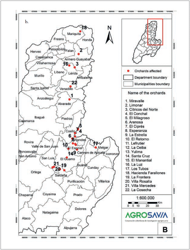
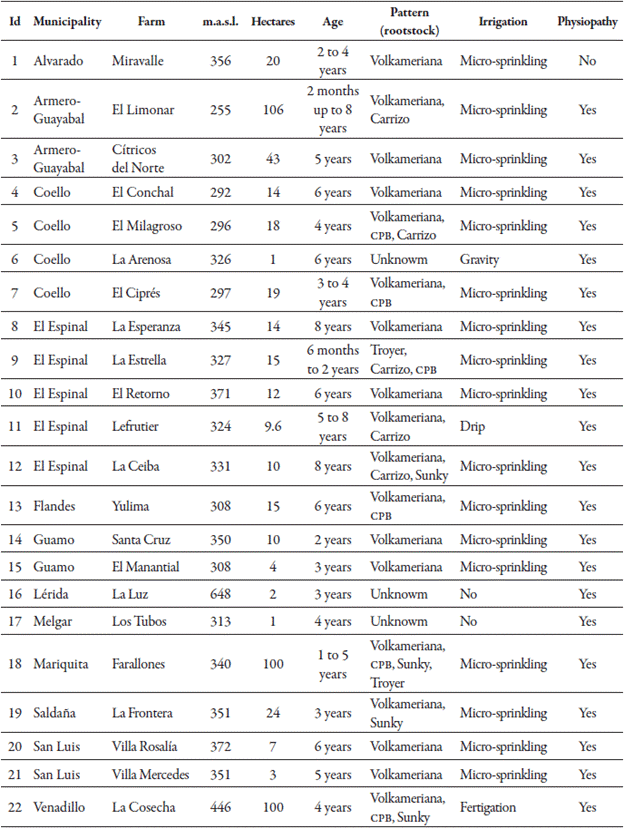
In figure 1a, the farms identified as Tahiti lime producers from the database provided by Yuma (property of ICA) are shown. In figure 1b, the farms with the presence and showing symptoms of the physiopathy are spatially related and were later verified in the field by the executing team. On the other hand, table 1 lists the properties, the municipalities and site details, such as the rootstock reported by the producer, the irrigation management used, if existing, and the type of irrigation system used for that purpose.
Source: Elaborated by the authors
Figure 1 Location of farms in the study area. a. Farms cultivating Tahiti lime in Tolima.
Source: Elaborated by the authors
Figure 1 Location of farms in the study area. b. Sites with Tahiti lime orchards in which the physiopathy has been verified.
Table 1 Farms with Tahiti lime orchards in which the physiopathy has been verified
Source: Elaborated by the authors
Likewise, an area where the physiopathy does not occur is reported, i.e. in Alvarado (Miravalle farm), and in which minimum temperatures of 21.7 °C and maximum of 33 °C are recorded, similar to those reported in areas with the physiopathy. Nonetheless, the difference in this farm compared to others is the age of the crop, which has not reached a stable production, plus the fact that it has a daily irrigation scheme.
Climate
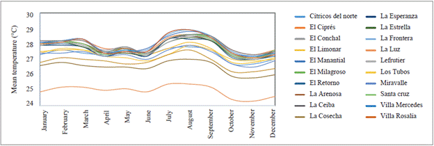
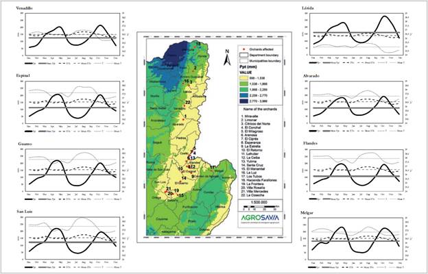
According to the WorldClim information, the affected orchards are located in an area with average monthly temperatures ranging from 24 °C to ca. 29 °C, and the farm La Luz in the municipality of Lleida, was the one with the lowest averages of monthly temperature. In turn, the farm El Ciprés located in the municipality of Coello, recorded the highest average values.
In all the orchards studied, the months of July, August and September were those in which the highest temperature averages were reached. Afterwards, the temperatures decreased, and in October, November and December, the lowest temperatures of the year occurred (figure 2).
Source: Adapted from Hijmans et al. (2005)
Figure 2 Average monthly temperature of the farms sampled.
Nonetheless, the average annual minimum temperature reached in the farms is close to 22.0 °C, with the exception of Miravalle (Alvarado), La Luz (Lérida) and La Cosecha (Venadillo), with 21.7 °C, 19.9 °C and 21.1 °C, respectively.
Similarly, the maximum annual temperature averages are close to 33.0 °C in most of the farms, except in La Cosecha (Venadillo), Farallones (Mariquita) and La Luz (Lérida), with 31.9 °C in the first two cases, and 30.1 °C in the third case. Further, during July and August the highest maximum temperature values of all the farms were found.
On the other hand, the monthly temperature range, which is the variation of the temperature between its maximum and minimum monthly values, show that during the year in most of the municipalities, the temperature varies on average 11.0 °C, with exception of Farallones (Mariquita), where the range is 10.1 °C on average. July and August are the months in which there is a greater variation, with an average of 12.5 °C, and the month with the smallest variation is November, with an average of 9.7 °C.
It should be noted that the temperatures reported in the study area exceeds the mean (23.4 °C) and the minimum (12.5 °C) that Hernández, Mateus and Orduz-Rodríguez (2015) rated as optimal for the Tahiti lime. Since the temperature is a measure of heat and is the precursor of the change in the state of the water, as it increases, a greater water volume passes from liquid to vapor, draining the surrounding medium, and causing the atmosphere to demand more water. If there is no water available in the soil, stomatal closure occurs, with the consequent slowing or blocking of physiological functions.
With regard to precipitation, the farms are located in an area with a bimodal regime, with a first maximum in the months of April and May, and a second one in October. The driest periods occur in June-July-August and December-January-February (Figure 3). Likewise, they are in an area with annual rainfall ranging from 1,265 mm (El Conchal in Coello) to 1,987 mm (Farallones in Mariquita). The municipality of Coello shows the lowest values.
Source: Adapted from Hijmans et al. (2005)
Figure 3 Distribution of the average monthly multiannual precipitation. Red dots: verified farms. Ppt: precipitation; Media Ppt: mean temperature; ETo: evapotranspiration; T: temperature; Media T: mean temperature.
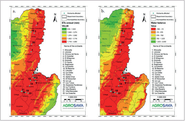
In the study area, evapotranspiration is above 1,600 mm/year (figure 4a), which means that, with the exception of the farms Farallones (Mariquita) and La Luz (Lérida), water deficit occurs in 8 of the 12 months of the year. In this sense, the monthly imbalance of the dry months would be what enhances the appearance of the physiopathy in Farallones and La Luz (table 1). In Figure 4b, the multi-year monthly average water balance is related to the study area.
Source: Adapted from Hijmans et al. (2005)
Figure 4 Water balance analysis in the study area. a. Average annual evapotranspiration (mm/year); b. Total annual water balance (mm/year). Blue dots: Verified farms.
On average, the highest rainfall deficit values (> 90 mm) are found in all farms during the months of January, July and August. In April, May and October there is no water deficit in any of the farms verified, taking as a reference the balance between precipitation, minus evapotranspiration.
However, the positive balance that occurs in some months does not imply an equally positive effect (prevention or reduction) in the physiopathy, since an important issue must be considered: how much of the precipitation remains stored in the soil and for how long, until it rains again.
When the environmental condition of high temperatures and water deficit is continuous, as occurs in the study area, systemic failures and permanent structural damage occurs (Pérez-Pérez et al., 2010). In the case of the physiopathy, tracheid cavitation and rupture with subsequent vascular system failure occurs, so the plant stops capturing nutrients and water, and consequently, tissue dies.
The death of trees observed in the study area orchards is sequential. Plant shows sectorized damages, which are expressed in tissue dehydration and wilting (leaves, stems and fruits). This expression is a clear example of an inadequate water management of the orchard, as supplementary irrigation correctly applied could contribute to overcome harsh climatic conditions.
Water management
Regarding water management, except for the farm La Luz in the municipality of Lleida, all other farms reported having and applying irrigation; moreover, the most common system used is micro-sprinkling. However, irrigation is carried out without any previous study in which the effective water use by the crop has been previously established, and in some cases, it is carried out at night.
Regarding the farms in Coello, El Espinal and Flandes, before the study was conducted, the producers carried out a physical soil analysis, which indicated that these soils had low water retention. However, these results were not considered for irrigation scheduling. In these farms, irrigation is carried out, on average, with a frequency of three days in periods of two to three hours. This however, is completely inadequate.
Regarding the soil storage analysis, the results of this study show that the permanent wilting point (PWP) is reached in less than 18 hours. Namely, the orchards with irrigation frequencies of three days remain in complete hydric deficit during more than 50 hours.
Besides this temporality in irrigation, the application form must also be considered. The predominance of micro-sprinkling irrigation with a single emitter is observed for the entire root area, with no possibility to change its position. This implies that only a percentage of the root area is being hydrated, which explains why the observed physiological damage is sectorized.
Edaphic characterization
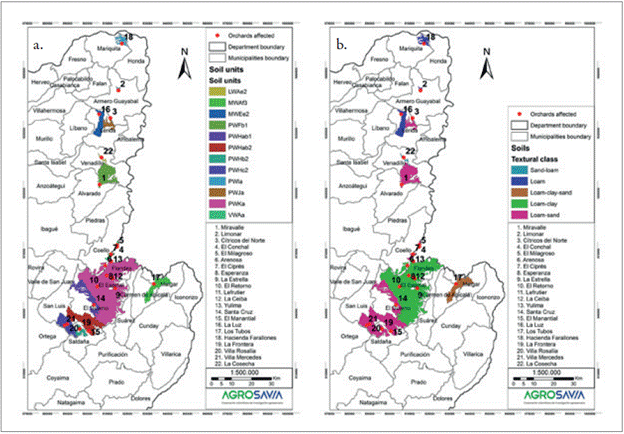
According to the cartography elaborated by igac at a scale of 1: 100,000, Tahiti lime orchards are distributed in 11 soil units (figure 5), and the most common is the PWKa unit (table 2). In this unit, seven orchards are located, which have flat reliefs with slopes from 1 % to 3 %, as well as a dry warm climate, corresponding to the tropical dry forest life zone (Cortolima, 2006). Its parent material is comprised by recent alluvial sediments, which cover tuff deposits.
Source: Adapted from Malagón-Castro, Pulido-Roa, Llinás-Rivera, Chamorro-Bello, & Fernández-Lamus (1995)
Figure 5 Soils found in the study area. a. Soil units; b. Soil texture. Red dots are verified farms. Arenoso: Sandy; Franco: Loam; Arcilloso: Clayey. Red dots: Verified farms.
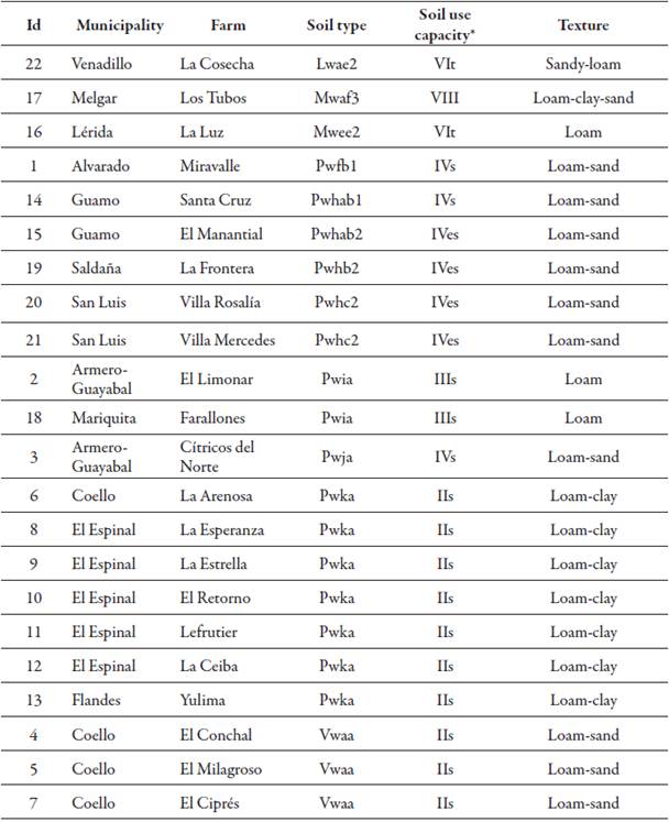
The next soil unit is the VWAa unit with three orchards (table 2), is located along the Magdalena River in a dry hot climate. Their soils have evolved from recent, fine and medium alluviums (Cortolima, 2006). Table 2 shows the area where Tahiti lime is produced in Tolima, showing different soil use capacities, given their physical characteristics, relief and natural and anthropic limitations for agricultural production. Near Coello and El Espinal, the soils show minor limitations to agricultural practices, and they require an adequate management for their conservation, i.e. this are features of class IIs. Regarding class IIIs, located near Mariquita and Armero-Guayabal, soils have moderate limitations for production, and just as in class IIs, compact layers that block root penetration to greater depths represent the main limitation. Towards the municipalities of San Luis, Guamo and Saldaña, soils are classified as class IVs and IVes, limited by erosion processes and root penetration blockage. The VIt class located in Venadillo and Lérida, indicates that these are low fertility soils with severe use limitations, reserved for perennial crops with intensive management practices for their conservation. In Melgar, a class VIII soil is observed, which indicates that these lands have no agricultural use capacity and are strictly for conservation purposes (IGAC, 2004).
The nomenclature of the units indicates that the totality of the orchards showed a dry warm climate (w), 15 of them are located in foothills landscape (P), 3 in valleys, 2 in mountainous areas and one in hilly regions. Most of these units have well-drained surface soils.
In terms of texture, 10 out of 22 orchards have loam-sand soils (FA), meanwhile in seven of them the texture is loam-clay (FAr) (figure 5, table 2). On average, the orchards have an effective depth of at least 40 cm, ideal for adequate crop development.
Hydrodynamics
The characterization of water movement in the soil was carried out in three of the farms linked to the study, El Ciprés (Coello), La Ceiba (El Espinal) and Yulima (Flanders). The soils of this area belong to the El Espinal range, formed by eruptions of the Machín volcano, with pyroclastic flows and deposits. When these were washed, they generated mudflows that were channeled through the Coello River and reached the Magdalena river valley, where they accumulated (Cortolima, 2006, Ingeo-minas, 1998).
In the farms La Ceiba and Yulima, hydraulic conductivity values range between 0.33 and 0.69 m/day, which is classified as moderate, and given the conditions of sandy soils, compaction problems are generated. In the farm El Ciprés (Coello) hydraulic conductivity was moderately fast, indicating good internal drainage. Under these conditions, moisture does not reside, so it is not stored in the root zone, and it infiltrates to deeper horizons. This means that soil water balance can be negative in a very short time, even in less than a day.
Regarding basic infiltration, in the farm Yulima is classified as moderate, with an average of 15.9 mm/h, that in case rainfall exceed these infiltration values, waterlogging becomes probable. Meanwhile, in the farm La Ceiba it is fast (36.4 mm/h) in the first 20 cm of depth.
Conversely, in the farm El Ciprés the basic infiltration is very fast (154.1 mm/h), which indicates that there should be no waterlogging problems. This parameter also indicates that these soils have storage problems, both in the surface as well as in deep layers, which minimizes the periods in which plants have water available.
The mechanical resistance to penetration, measured with the methodology proposed by Pla (1998), alludes to the effort that the root must make to explore the soil. In terms of compaction, the soil of the Yulima farm shows a slight restriction to the development of the roots in the first 5 cm of depth, with a resistance of 3.7 MPa. From this point and up to 17 cm of depth, the restriction increases; that is, root development becomes more difficult, showing the resistance a value above 5.0 MPa. The measurement with the penetrometer was only possible up to this point.
At the same time, in the farm La Ceiba, the restriction is low in the first 40 cm of depth, with resistances of ca. 3.0 MPa, and from this point onwards, it becomes high (> 4.0 MPa), due to the presence of a hardened layer. Once that layer is overcome, it becomes slight again (< 3.0 MPa); however, it is worth noting that there are no roots beyond this point.
Meanwhile, in the farm El Ciprés, the restriction is low (around 3.0 MPa) in the surface layer and becomes high after 10 cm of depth (> 3.5 MPa), and remaining the same with depth. This could be due to the fact that in the soil matrix there is a thick continuous layer of coarse gravel, which blocks the penetration of the equipment.
This generalized condition in the study sites where roots have limitations for their development, could generate plants with very superficial roots, which can cause overturning in mature plants and rapid dehydration. In addition, this limitation, together with a low moisture content and distribution, prevents the plant from exploring a greater soil volume, which minimizes the contribution to atmos-pheric demand and increases resistance to movement in the air system (Rodríguez-Gamir et al., 2010).
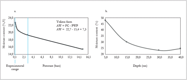
Water storage in the soil
The soil of the Yulima farm has low water storage in the root zone, with a field capacity (FC) of 22.7 %, a permanent wilting point (PWP) of 15.4 %, and only 7.3 % of storage capacity (Figure 6a). This implies that the amount of water that the plants can use is even smaller (Pérez, 2008). It should be noted that these soils are of colluvium-alluvial origin, with materials deposited by eruptions of the Cerro Machín volcano and sediments of the Coello, Cucuana and Magdalena Rivers (Ingeominas, 1998).
In general terms, these materials provide adequate porosity and aeration, but they affect water storage, given the scarce contribution of fine sediments (Cortolima, 2006). A physical limitation is evidenced at 15 cm of depth (figure 6b), finding a large amount of continuous rocks, which hinders the development of roots, and clearly, decreases water retention.
At the Yulima farm, the producer reported that irrigation is carried out with modal periods of three hours and a frequency of two days. This management implies that the plant remains in deficit most of the time, even if it is irrigated with a high volume of water. Simulating an irrigation process with an initial humidity of 15.6 %, field capacity in the soil (approximately 23 %) was achieved thirty minutes after it started.
Later, a soil moisture sensor located at 20 cm of depth recorded a humidity of 33.8 % during the next irrigation hour. This means that the soil was saturated, and the humidity did not increase with time. Once the irrigation was suspended, drainage took 15 minutes to reach field capacity again. The above mentioned indicates that, although water continues to be applied infinitely, moisture is not stored beyond field capacity, and that it is only necessary to apply water for 0.5 hours to achieve the maximum adequate storage for this type of soil.
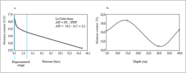
On the other hand, the soil of the farm La Ceiba showed a low water retention. An in-depth explo-ration was carried out with a Dutch type borer, to identify at what depth the roots were located, and the presence of any barrier or compacted layer in the profile, taking into account the waterlogging processes that were observed on the surface.
Nonetheless, the highest percentage of roots were found in the first 15 cm. From this depth and up to 40 cm, there was a predominant sand outcrop with some degree of compaction, both in surface and in depth (apparent density: 1.5). From 40 cm of depth, there was a physical limitation, represented in a compact layer difficult to penetrate, which affected the development of the roots.
This layer acts as a "bottom" that with excessive water, the area "fills up”, i.e. produces a deep waterlogging that appears in the surface and can be maintained up to 24 hours. This condition is generalized in the orchard, but is not homogeneous, indicating that in some places, this hardened horizon is absent or has suffered a rupture.
The level of storage defined as available water is low (5.5 %), FC is 19.2 % and PWP is 13.7 % (figure 7a). Figure 7b shows an increase in depth moisture, which may be due to fine material deposits, which easily penetrates the first 30 cm between the sand. Then, there is a limitation in their transit to bigger depths, and therefore, these are deposited.
Source: Elaborated by the authors
Figure 7 Characteristics of soil storage for the farm La Ceiba. a. Water retention curve; b. Storage (FC level) at different depths. AA: available water; FC: field capacity; pwp: permanent wilting point
It is necessary to mention that in this farm, it is not advisable to break the hardened layer found at 40 cm of depth, since, beyond this deposit, permeable horizons are found (Ingeominas, 1998). Breaking this layer would allow water flow to deepen, generating water imbalances that would be even more drastic than those caused by the environmental supply.
The recommendation for this situation would be to adjust the water supply according to storage processes, avoiding excessive water levels that brings the profile to the level of filling, and increase daily watering frequency with short periods, in accordance with the recommendation of the adequate crop moisture content.
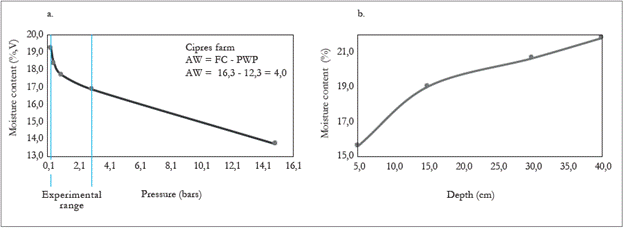
On the other hand, the soil of the orchard El Ciprés has a sandy texture (A) in depth, with very little storage capacity (Pérez, 2008), with a FC of 16.3 % and a PWP of 12.3 %, whereby storage represents only 4.0 % (figure 8a). A deep exploration was carried out in the farm observing that the highest percentage of roots develop in the first 40 cm.
Source: Elaborated by the authors
Figure 8 Soil storage characteristics for the farm El Ciprés. a. Water retention curve in the farm; b. Storage (FC level) at different depths. AA: available water; FC: field capacity; pwp: permanent wilting point.
Due to the consumption of water carried out by the plant, to the evaporation and the internal drainage that occur this soil dries quickly. In addition to the excessive presence of sand in the profile (from 15 to 40 cm), there is a continuous layer of rocks, which represents a physical limitation for the development of roots and water retention.
Around 15 cm of depth the presence of roots and organic matter improves storage, although not significantly (figure 8b). Notice should be taken regarding the limiting effect of rocks in depth, where between 15 and 30 cm, the soil shows a decrease in storage.
By simulating an irrigation event, humidity quickly reached field capacity. Then, the soil was allowed to drain until it was "dry", with a pressure of 3.0 bar (14.5 % humidity) in 2.5 hours. The humidity continued to decrease until reaching the PWP in an average of 18 hours. That is, if irrigation is carried out with a frequency of 24 hours (typically in the region producers do it every 72 hours), when the next irrigation is carried out, the plant has stopped having water available for six hours. This excessive loss of moisture is mainly due to internal drainage when the irrigation application ends until reaching field capacity.
Biophysical analysis
The results of the edaphoclimatic characterization show a perennial fruit crop exposed to a situation of water deficit during a large part of the year due to climatic conditions, in which the atmospheric demand exceeds the supply of rainfall by 34 %.
In addition to climate, these areas have sandy soils that are highly draining, and in some cases, there are slopes, which increase drainage. Additionally, the orchards do not have irrigation systems that compensate water deficit, and the producers who have these, perform the work empirically, without using controlled systems or technical recommendations for water use depending on the crop.
The problem then consists of citrus orchards subjected to water deficit, that as stated by García-Sánchez, Carvajal, Porras, Botía and Martínez (2003) and Quiñones, Martínez-Alcántara and Legaz (2007), are negatively affected in their physiological functions, i.e. photosynthesis, respiration, metabolic and anatomical reactions, growth, reproduction, seed development, absorption of mineral nutrients, transport of assimilates and production.
According to Ballester, Castel, Intrigliolo and Castel (2011), the effect of stress depends on the intensity of the deficit, its duration and the time it occurs within the crop cycle. Moreover, the Tahiti lime producing area has two peaks of production, one around February and March for the first cycle, and a second one in August and September.
Consequently, although it benefits flowering induction, the deficit could be affecting fruit set and filling processes (González-Altozano & Castel, 2003; Vélez et al., 2012). As an effect of the deficit, there were orchards that showed the physiopathy from four and even from two years of age, affecting the health of trees and limiting the development of structures, until premature death occurs.
Conclusions
The study area, considered one of the most important Tahiti lime production regions in the country, has an edaphoclimatic condition characterized by high temperatures, high atmospheric demand, low rainfall, poor water storage in the soil, and therefore, water deficit for the productive maintenance and health of orchards.
This environmental condition has promoted the development of a physiopathy in producing citrus plants, which has generated the deterioration of trees, a fall in production, and in many cases, the death of plants. Water deficit can be overcome with an adequate irrigation management, since it is the most relevant factor when dealing with a physiopathy.
Despite this, producers do not irrigate correctly. They do it with a frequency of 72 hours in a productive environment where available water is exhausted in less than seven hours. That is, plants are permanently exposed to situations that generate water stress, and hindering their normal vegetative and productive behavior. In these biophysical conditions, orchards should be watered with frequencies not exceeding seven hours, i.e. twice a day during daylight hours, bringing the soil to a water content close to field capacity.
Recommendations
The drainage in the studied sites is efficient and accelerated, given the presence of thick materials arranged by the dynamics of the Magdalena River and its tributaries. Some orchards are located on a slope, so material deposits are differential; this leads to the presence of deep gravel horizons in the sectors near the river that are shallow in the highest areas of the orchard. This non-homogeneous water storage conditions implies that irrigation management must be differential. In the orchards studied, it would be advisable to add organic matter, which helps improve water retention and the physicochemical properties of the soil.
Likewise, it is necessary to improve the frequency of nutrition application, since it has been observed that producers fertilize every four months, and some, even every six months. As recommended for irrigation, nutrition should be applied with higher frequency, since the low retention capacity also includes nutrients. Thus, these can be washed with the high irrigation volumes applied by producers, a problem that is intensified by the lack of clay particles to retain these.

