


Serviços Personalizados
Journal
Artigo
 texto em
  Inglês (pdf)
 Artigo em XML
 Referências do artigo
 Enviar este artigo por email
Indicadores
-
 Citado por SciELO
 -
 Acessos
Links relacionados
-
 Citado por Google
 -
 Similares em
SciELO
Similares em
SciELO -
 Similares em Google
Compartilhar

 Permalink
Ciencia y Tecnología Agropecuaria
versão impressa ISSN 0122-8706versão On-line ISSN 2500-5308
Cienc. Tecnol. Agropecuaria vol.20 no.2 Mosquera maio/ago. 2019
https://doi.org/10.21930/rcta.vol20num2art:1462
Sistemas de información, zonificación y georreferenciación (agricultura de precisión)
Ecoterritorial sectorization for the sustainable agricultural production of potato (Solanum tuberosum L.) in Carabobo, Venezuela

1Investigador, Programa de Doctorado en Ingeniera Agraria, Alimentaria, Forestal y del Desarrollo Rural Sostenible,Universidad de Córdoba. Córdoba, España.
2Coordinador de Meteorología Agrícola, Instituto Nacional de Meteorología e Hidrología (inameh). Baruta, Venezuela.
3Corporación Colombiana de Investigación Agropecuaria - Corpoica
In Venezuela, a total of 5.4 % of the territory under agricultural use is dedicated to the production of roots and tubers corresponding to 93,677 ha, of which an important potato production center is concentrated in the state of Carabobo; however, there are currently land use conflicts. This research aimed to define suitable areas for potato cropping (Solanum tuberosum L.) in the agricultural regions of the Carabobo state as an essential task for its sustainable development. The agroecological zoning methodology of the Food and Agriculture Organization of the United Nations (fao) was applied, based initially on the analysis of climatic factors, and then, on the analysis of soil characteristics to obtain the physical characterization of different areas. Subsequently, the environmental demands of the crop were confronted attaining the sectorization of greater or lesser adaptability areas. The largest area corresponds to agricultural suitability zones that occupy 337.0 km2, showing the Libertador and Valencia municipalities the highest proportion of these. This study is a tool to achieve a greater land use in economic, ecological and social sustainability terms.
Keywords agriculture; climate; land use; potatoes; sustainability; zoning
En Venezuela, un total del 5,4 % del territorio de uso agropecuario se dedica a la producción de raíces y tubérculos, lo que corresponde a 93.677 ha, de las cuales una importante producción de papa se concentra en el estado Carabobo; sin embargo, actualmente existen conflictos sobre el uso de la tierra. El objetivo de esta investigación fue definir áreas aptas para el cultivo de papa (Solanum tuberosum L.) en las zonas agrícolas del estado Carabobo como tarea indispensable para el desarrollo sostenible. Se aplicó la metodología de zonificación agroecológica de la Food and Agriculture Organization (fao), basándose, en primer lugar, en el análisis de los factores climáticos y, luego, en el análisis de las características del suelo, a fin de obtener la caracterización física de las diferentes áreas. Posteriormente, se confrontaron las exigencias ambientales del cultivo, obteniendo la sectorización de las zonas de mayor o menos adaptabilidad. La mayor superficie corresponde a las zonas con aptitud agrícola que ocupan 337 km2, siendo los municipios Libertador y Valencia los de mayor proporción. Este estudio constituye un instrumento para lograr un mayor aprovechamiento de las tierras.
Palabras clave agricultura; clima; papa; sostenibilidad; utilización de la tierra; zonificación
Introduction
In Venezuela, the Andean states of Mérida, Táchira, and Trujillo lead the production of potato (Solanum tuberosum L., 1753) throughout the year (Salazar, Zambrano, & Valecillos, 2008). However, in some areas of the states of Lara, Aragua, and Carabobo, potatoes are also cultivated in these areas applying management techniques, that together with soil and climate conditions, allow crops to be harvested at least twice a year.
In general, the technological profiles for the production of roots and tubers in the productive regions are inadequate. These systems are characterized by the limited and inadequate implementation of agronomic practices as the use of associated crops, genetic resources and irrigation schemes, that leads to high production costs (Ministerio del Ambiente y los Recursos Naturales [marn, for its acronym in Spanish], 2005; Ovalles, Cortez, Rodríguez, Rey, & Cabrera-Bisbal, 2008; Rodríguez, 2010).
The term “sustainability” is used in agro-environmental systems to describe their maintenance over time. Consequently, the main factors that damage the sustainability of agricultural systems include soil degradation and water scarcity (Paredes-Trejo & Olivares, 2018), generating the loss of soil fertility and the decrease in productivity, as well as essential limitations in crop yield and food production demanded by the population in general (Pla-Sentís, 2010).
The agricultural sector is particularly sensitive to land degradation processes and the effects of climate change. Therefore, on the basis of what was stated above and the commitments made by Venezuela, the agricultural component is strategic for the country, highlighting three topics: 1) food security, 2) life quality of the rural population, and 3) land use planning mainly related to land use changes (Red Interamericana de Academias de Ciencias [ianas, for its acronym in English], 2017; Romero & Monasterio, 2005).
It is noteworthy that the scarcity of consolidated information on the identification, characterization, zoning and evaluation of production systems at the producer level, particularly regarding its conditions, has affected the possibility of having a current and firm vision on the best productive, competitive and sustainable options, as a critical element for the guidance and formulation of planning and research actions and policies on natural resources management at the local level.
The identification of territories with suitable features for the establishment of crops represents an important point when planning any local or regional agricultural development program. In general, this study will allow carrying out the rational exploitation in the area of interest, considering the productive capacity of the natural resources as well as the conservation of the ecosystems (Cortez, Núñez, & Rodríguez, 2007; Sediyama-Chohaku et al., 2001).
Zoning a crop represents the sectorization of a territory with different criteria to determine homogeneous geographical units from the perspective of their physical, biological, social and economic characteristics, and with ecological potential for the establishment of sustainable agricultural systems (Espinosa & Orquera, 2007; Olivares, Hernández, Coelho, Molina, & Pereira, 2018a, 2018b; Suárez, 2014). In general, a relevant aspect when carrying out this kind of study is associated with the more rational use of the natural resources (Garea, Soto, & Vantour, 2008) through space ordering and planning (Soto et al., 2007), as well as by the increase in the compatibility between crop requirements and the agroecological conditions of the environment (Food and Agriculture Organization [fao], 1997).
Accordingly, this study aimed at defining suitable areas for the cultivation of potato (S. tuberosum) in the agricultural regions of the Carabobo state in the central region of Venezuela, as a working, consultation and orientation tool that can be used by any initiative related to the agricultural activity in the area.
Materials and methods
Study area
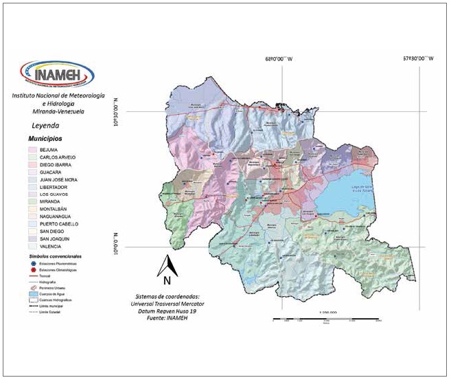
The Carabobo state is located in the northerncentral region of Venezuela between the geographic coordinates 09°48' and 10°35' of latitude N, and 67°31' and 68°26' of longitude W (figure 1); The total area is 4,651 km2 of which only 42.53 % (1,973 km2) is suitable for the development of agricultural activities.
The average annual rainfall in the Carabobo state is 1,100 mm. Accumulated rainfall ranges between 1,100 and 1,300 mm in the depression area of Lake Valencia, formed by low mountains, hills, and valleys that drain through alluvial and lake plain reliefs (Olivares, 2018). Most of the territory is categorized by having a dry sub-humid (C1) climate comprising an approximate area of 2,791.15 km2, i.e., 60% of the region (Olivares, Hernández, Cohelo, et al., 2018a).
From an agrological point of view, the highest proportion of soil in Carabobo is classified as Class I, followed by the other classes up to Class VIII soils. These classes represent the soils with ideal characteristics or that are less limiting for the agricultural production in the territory that covers an area of 103,700 ha (Comerma, 2009).
Methodological components of the ecoterritorial sectorization
The ecoterritorial sectorization is a resource of particular interest for the agricultural development of a study area because optimum environmental conditions are established for a plant species where its maximum production potential is feasible. Namely, it is possible to interrelate the factors that affect the development of the crop such as climate, soil, relief, and agroclimatic requirements, amongothers, to establish a map showing the suitabilitydegree of the land.
Figure 2 describes how to apply the procedures included in the ecoterritorial sectorization methodology, which attempts to estimate land suitability and potential productivity focusing on potato (S. tuberosum) production systems.
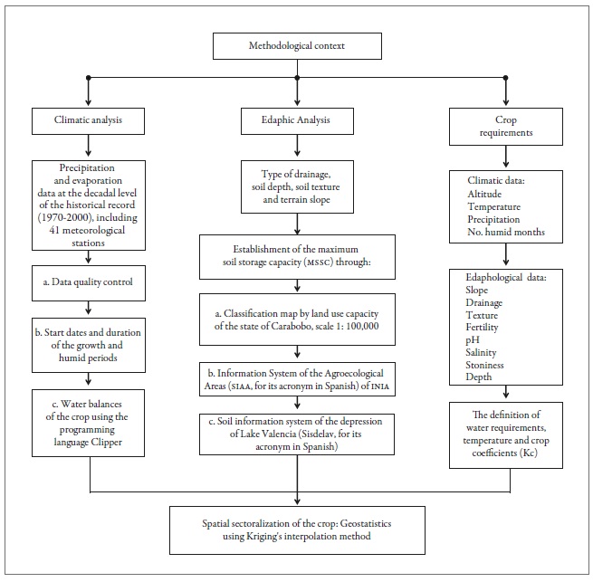
Climate analysis phase
To elaborate water balances for potato, the analysis of decadal precipitation (accumulated precipitation of 10 days) in the Carabobo state for the period between years 1970 and 1999 and corresponding to 41 meteorological stations, was carried out. Daily data series were filtered, complemented, and then converted to decadal data. These procedures were carried out through the quality control of meteorological information, as well as by using statistical analyses and methods already established for the estimation of missing and aggregate daily data (Hernández et al., 2017; Olivares, Cortez, Parra, Rodríguez, & Guevara, 2013; Parra & Cortez, 2005).
Nonparametric tests to verify the homogeneity of the precipitation and evaporation data were applied. Daily historical precipitation records were obtained by calculating missing data using correlation methods, distances, and normal values; similarly, for their apportionment, the nearest neighbor method was used (Olivares et al., 2013). Regarding missing daily air surface evaporation data (type A tank), regional homogeneity and the nearest neighbor methods were applied.
Reference or potential crop evapotranspiration (ETp) was calculated using the Penman-Monteith FAO method (Allen, Pereira, Raes, & Smith, 2006). Subsequently, to establish the water supply and demand of suitable agricultural lands in the Carabobo state, the water balance of the crop for each climatological station was calculated using the programming language Clipper (Hernández et al., 2017), which provided information to perform an edaphoclimatic risks analysis.
Clipper calculated an average of 42 water balances for potato, assuming as the sowing date each of the decades of the year. Furthermore, it estimated the effective precipitation from the slope of the terrain, and it calculated the water storage in the soil during three decades before the planting date to ensure an adequate moisture content at that time. Also, it calculated the decrease in yield by deficit using the Ky index, and the reduction in yield by excess employing the Food and Agriculture Organization method ( 11); the latter was used because it is a practical and useful methodology adapted to the tropical conditions of the productive systems and ecological interactions.
The methodology published by Franquín (1983) was developed for the analysis of the start dates, duration, and water layers accumulated through rainfall for the growth and humid periods, according to the probability of occurrence levels of 50 % and 75 %. This information is useful to reduce the uncertainty of the agricultural activities, as well as in the growth stages of the crop that are related to their water requirements.
Edaphic analysis phase
The land-use aptitude classification map of the Carabobo state elaborated by Dirección General de Recursos Hidráulicos of Ministerio de Obras Públicas (1971) at a scale of 1: 100,000 was used as a base for the edaphic analysis, as it is the only soil study available (Hernández et al., 2017). The edaphic qualities assessed were the type of drainage, the depth, the soil texture and the slope of the terrain, essential variables to calculate the maximum soil storage capacity (mssc).
Additionally, also data from the Information System of Agroecological Areas (siaa, for its acronym in Spanish) of Instituto Nacional de Investigación Agrícola (inia, for its acronym in Spanish) [National Institute of Agricultural Research] ( 17), and the Soil Information System of the Depression of Lake Valencia (Sisdelav, for its acronym in Spanish) (Viloria, Estrada, & Rey, 1998) were used.
Evaluation phase of crop requirements
Crop requirements were defined using the contributionsof Benacchio (1982), who compiled thewater requirement, the temperature and other climaticfactors that affect the development of differentcrops in tropical environments (table 1). Cropcoefficient values (Kc) were taken from Doorenbosand Kassam (1979) and Doorenbos and Pruitt(1975).
Table 1. Edaphoclimatic and nutritional requirements for potato (S. tuberosum) cultivation
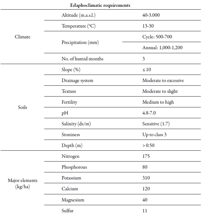
Source: Adapted from Benacchio (1982) and INIA (2016)
The phenological phases of potato considered and described below are the ones indicated by Hack et al. (1992):
Emergence: The first leaves appear on the soil surface.
Lateral buds: The buds that emerge from the main stem are aerial and underground. The first ones develops into the foliage of the plant, and the second ones develops into the rhizomes, which later swell in the distal portion forming tubers.
Floral button: The first flower buttons appear.
Flowering: The first flowers open.
Maturation: A change in leaf color must be observed, as there is a direct relationship with tuber maturation. Moreover, the base of the plants must be uncovered to see if the potato skin adheres well and if it does not come off, i.e., a potato is ripe when it does not lose its skin when it is pressed with the fingers.
Potato plants are resistant to drought during their phenological phases, which is reflected by the Kc index. Table 2 shows the Kc index values for this crop.
Table 2. Crop coefficients (Kc) in a growth cycle of 140 days
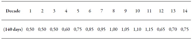
Source: Adapted from Doorenbos and Kassam (1979) and Doorenbos and Pruitt (1975)
Water requirements vary from 1,000-1,200 mm and are well distributed during the crop cycle. The highest water demands if found in the germination and tuber growth stages, so it is necessary to irrigate the crop in these critical periods, especially when no rainfall occurs. The final crop development stages are the most susceptible to water deficit, and in these, the yield can be reduced considerably depending on whether this deficiency occurs in the initial stages; besides, these do not tolerate drought for long periods.
Ecoterritorial sectorization
The main objective of this methodology is to compare crop requirements in terms of soil and climate, and the edaphoclimatic "supply" of the area, to quantify how satisfactorily the requirements are covered and, consequently, the degree of suitability that the area has for potato cultivation. Accordingly, first, soil, climate, and crop relationships are analyzed separately, and then they were integrated to obtain a single result (Ministerio del Ambiente y los Recursos Naturales Renovables [marnr], 1989; Olivares, Hernández, Arias, Molina, & Pereira, 2018a).
The result of the water balance allowed analyzing the maximum crop evapotranspiration (ETm), the crop yield, the yield response factor to water (Ky), the crop coefficient (Kc), the relation between the water demand of the crop (real crop evapotranspiration [ETa]) and the demand of the reference crop (ETp). Moreover, also the yield percentage for an estimated sowing date that guarantees an initial soil humidity.
Furthermore, fao (2012) addressed the relationship between crop yield and water use and proposed a simple equation that related the relative decline in yield with the corresponding relative decrease in evapotranspiration (et). Specifically, the yield response to et is expressed in equation 1.
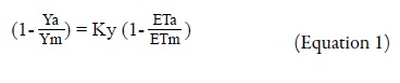
Where Ya is the real yield harvested, Ym is the maximum yield harvested, Ky is the yield response factor to water, ETa is the real crop evapotranspiration, and ETm is the maximum evapotranspiration of the plant.
The Ky factor captures the essence of the complex relationships that exist between production and water use in a crop, where biological, physical and chemical processes occur. The relationship has shown remarkable validity and has provided a procedure that is useful to quantify the effects of water deficits on yield ( 12; Olivares, Hernández, Arias, Molina, & Pereira, 2018b).
According to fao (2012), the procedure for calculating equation 1 to establish the real yield is comprised of four steps: i) estimating the maximum yield (Ym) of an adapted crop variety according to its genetic behavior and the climate, assuming that agronomic factors (e.g., water, fertilizers, pests, and diseases) are not limiting. ii) calculate the maximum evapotranspiration (ETm) according to established methodologies and bearing in mind that all the water requirements of the crop have been supplied. iii) calculate the real evapotranspiration (ETa) of the crop in a specific case, according to the water supply available for the plant, and iv) evaluate the real yield (Ya) by appropriate selection of the response factor (Ky) throughout the growth period or in each of the different growth stages.
The faoIrrigation and Drainage N.° 33 study (Doorenbos & Kassam, 1979) recommended procedures to estimate the maximum yield from available local data on maximum crop yields or based on the calculation of maximum biomass and the corresponding harvest index, using the ecological zone approach (Kassam, 1977). Subsequently, a general adaptability criterion was established according to the Ya/Ym relationship (table 3).
Table 3. Adaptability ranges according to the ratio between the real yield harvested and the maximum yield harvested (Ya/Ym)
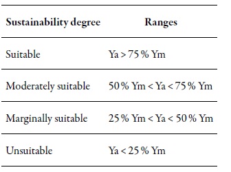
Source: Elaborated by the authors
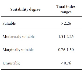
Then, the water requirements of the crops (ETa) were calculated for each suitability range, both for the vegetative cycle as well as for the critical stages, and were compared with the climatic supply of the study area, defined as the effective precipitation with 75% probability of occurrence. Subsequently, a total climatic suitability index (equation 2) was calculated to establish the degree of suitability (table 4).
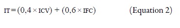
Where tiis the total index, vci is the vegetative cycle index, and cpi is the critical phase index.
An interpolation to map the edaphoclimatic variables was performed using the punctual Kriging technique. Further, a variation model was established using geostatistics (Webster & Oliver, 1990), which allowed defining the spatial structure of the properties and their estimation in sites not sampled by the Kriging interpolation method. The estimates were calculated using the semivariogram parameters adjusted by equation 3.
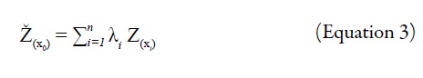
Where n is the number of samples neighboringZ(x0); λ is the relative weight applied to each Z(x1);Ž(x0) is the estimate of Z in x0, and Z(xi) is the samplenext to x0.
Once the file with the interpolated variables was generated, it was edited in the SIG program ArcView v.3.2., to be visualized, analyzed and classified (Environmental Systems Research Institute [ 9). This procedure allowed examining the spatial variation of suitable or unsuitable areas for the crop under study.
Results and discussion
Land suitability
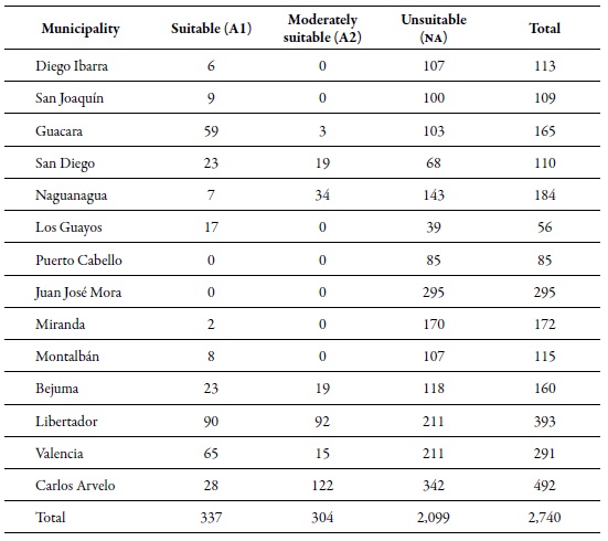
The superficial extension of the soils that is suitable for potato cultivation in the municipality of Libertador in the state of Carabobo is 90 km2; therefore, it is considered as the municipality with the most significant extension of arable lands for potato cultivation. The average annual rainfall ranges from 1,500 mm in the south to 1,000 mm in the north that corresponds to the depression of Lake Valencia and Serranía del Litoral. Table 5 presents the results of the ecoterritorial sectorization of potato in the state of Carabobo.
The estimated sowing dates for the cultivation of potato in suitable soils in the central-northern area were found between the third decade of May and the first decade of August. To the north of the town of Tocuyito, optimal sowing dates are found between the first decade of June and the first decade of August. On the other hand, to the northwest, the suitable sowing dates correspond to the second decades of June and of July.
Towards the south of the municipality of Libertador, the sowing date in some sectors was estimated between the second decade of June and the third of August; finally, in terms of suitable soils, the sowing date in some central and southeastern areas was estimated between the first and third decades of July.
It is convenient to indicate that, from the moment the plants are sown, the moisture content of the soil exerts a considerable influence throughout their development cycle. When there is excess water, the percentage of starches decreases and the appearance of certain pests, diseases, and weeds are favored. On the other hand, variations in the moisture content generate modifications in the thickness of tubers and the presence of cracks, furrows, constrictions, among other malformations. Studies report that the occurrence of water deficit before tuberization stimulates root lengthening, increasing the number of tubers significantly but their size is reduced considerably (Morales, Morales, & Rodríguez, 2015b).
Table 5. Land surface (km2) suitability for potato (S. tuberosum) cultivation per municipality in the state of Carabobo
Source: Elaborated by the authors
The occurrence of drought in the Venezuelan agricultural territories affects the vegetative growth of potatoes and inhibits tuberization, in particular, size and quality (Cortez et al., 2018, Parra et al., 2018). The critical periods of water needs in potato cultivation occur immediately after emergence and during tuberization (Morales et al., 2015b; Pino, Inostroza, Kalazich, Gutiérrez, & Castro, 2012).
Regarding the moderately suitable soils for the cultivation of potato, these cover an area of 92 km2 of the agricultural lands of the municipality.
The prevailing sowing dates are found between the second and third decades of May, as shown in figure 3. In some areas of the southern and central regions of the municipality of Libertador, the date was estimated between the third decade of May and the third of June. In specific areas of the northern region, the sowing dates were between the first decade of June and the third decade of July; in some sectors towards the northwest, it was estimated solely for the first decade of July, meanwhile in others, just in the second decade of July.
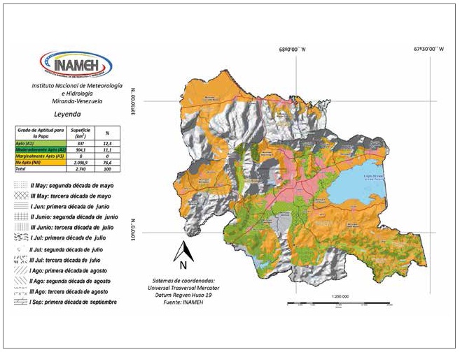
Source: Elaborated by the authors
Figure 3. Ecoterritorial sectorization of potato (S. tuberosum) cultivation in the state of Carabobo, Venezuela.
Agricultural lands of the municipality of Valencia where the capital of the state of Carabobo (the city of Valencia) is located, have 65 km2 of soils suitable for cultivating potato, with an estimated sowing date in the second decade of May in the southeast and to the north. Towards the south of the city of Valencia, planting dates range from the third decade of May to the first of August; in the south of the municipality, the dates are found between the second decade of June and the second decade of August. Meanwhile, in the rest of the suitable soils, potato can be sown between the first and third decades of July.
On the other hand, in this municipality, 15 km2 of moderately suitable soils were identified. The areas classified as moderately suitable for potato cropping are located north of the city of Valencia in hilly and mountainous areas where between 90 % and 95 % of the yield can be obtained during crop harvest. The estimated sowing dates for moderately suitable soils to achieve maximum potato yields of 95 % range from the second decade of May in the south and north. Further, between the first decade of June and the second decade of July in localized areas north of the city of Valencia, the estimated sowing dates for potato are found, and between the third decade of July and the first decade of September towards the center and northern areas of the municipality.
In figure 3, the municipality of Guacara can be observed as having soils suitable for potato cultivation, predominating low areas with hills, mountains and the zone corresponding to the lake plain north of Lake Valencia, which represents approximately 59 km2 of loamy and moderately drained soils. The sowing dates estimated for this region to obtain yields between 95 % and 100 % are found between the second and third decades of July to the east and northeast. Meanwhile, the rest of the suitable soils have a tentative sowing date for the third decade of July.
Regarding the moderately suitable soils for potato cultivation in the municipality of Guacara, an area of 3 km2 was identified with sowing dates estimated for the third decade of July, considering a maximum yield of less than 95 %. The above is the result of the light texture and the excessive drainage that these soils have, and therefore, the necessary humidity during the critical cultivation phases for potato is much lower than in soils of medium textures.
On the other hand, in approximately 122 km2 of the Carlos Arvelo municipality, planting dates were estimated for the second decade of May and the first decade of June, with the possibility of obtaining 90% to 95% yields during the harvest. This is because soils are moderately suitable for cultivating potatoes due to their edaphoclimatic conditions and because the water availability for critical crop phases ranges between 315 and 275 mm.
The municipality of Bejuma has an area of 23 km2 with soils suitable for growing potato, mainly in the area of the Chirgua Valley in the center of the region. The estimated sowing date for these zones is found from the second decade of May to the second decade of June, meanwhile, around the town of Bejuma, the dates were estimated between the third decade of May and the third of June. In the high areas of the valley, the sowing dates coincide between the first decade of June and the third of July. Also, the Chirgua sector is recognized as an important potato cultivation area in the country, due to the technification conditions of farmers.
Likewise, an area of 19 km2 of moderately suitable soils for potato cultivation in this municipality was found located in hilly and mountainous areas, with slopes between 6 % and 10 %. These areas have soils with sandy textures and excessively drained that reach a maximum yield of 95 %, and sowing dates are found between the first decade of July and the third of August. Water availability in these lands of moderate suitability shows values between 315 and 275 mm during the critical phase of the crop.
Potato yield values achieved in the study area are due to the genetic makeup of the cultivar used and the environmental factors of the region. In this sense, the temperature and the number of light hours represent the environmental factors of greater weight in the development cycle of a crop, without neglecting the vital contribution of soil moisture variations due to rainfall (Kooman, Fahem, Tegera, & Haverkort, 1996; Pereira, Villanova, Ramos, & Pereira, 2008; Quintero et al., 2009; Streck, Matielo de Paula, Bisognin, Heldwein, & Dellai, 2006).
In this regard, Spitters and Schapendonk (1990) established that there are potato varieties tolerant to drought; these keep their stomata open under severe water deficit conditions, so they maintain photosynthesis and the tissue damage of the leaves is lower, generating high yields.
According to Morales et al. (2015a), the high tolerance to drought of some potato varieties is mainly due to favorable anatomical and physiological characteristics to adapt to stress conditions, including lower stomata density, smaller stomata, a minimal decrease in the relative water content, and greater stability of the cell membrane.
Nonetheless, it is possible to resort to irrigation in dry seasons or during drought events to cover the water needs of the crop to maintain a constant production (Olivares & Zingaretti, 2018). However, there are areas in Carabobo where irrigation systems are scarce or null due to some factors that condition its use, such as inaccessibility to nearby water sources, lack of water service, and absence of infrastructure, among others.
Most of the potato production systems in the state of Carabobo are characterized by a dependence on imported seed, an insufficiency of certified seed, the use of traditional varieties with low yield, and high susceptibility to diseases ( 20; Olivares et al., 2017). Additionally, in some areas, there is inadequate use of water resources for irrigation, excessive use of pesticides, and incorrect management of chemical and organic fertilization practices.
Conclusions
In the Carabobo state, suitable agricultural areas correspond to the largest extension, occupying 337 km2 and representing 12.3 % of the surface of the state, whose climate and soil characteristics allow the sustained establishment of potato, and its water and soil limitations are mild. However, these limitations can be corrected or handled with irrigation management or soil and water conservation practices.
With the ecoterritorial sectorization map, areas with three agroclimatic suitability categories for potato cultivation were identified. This hierarchy allowed selecting suitable areas to guarantee a sustainable potato production, and constitutes a valuable alternative to improve agricultural production programs in the state of Carabobo, complemented with the experience of producers and with field research developed in the communities.
The use of the methodology proposed in this study allows modeling and characterizing the environmental variables entirely, and represents an ideal alternative that distinguishes potential cultivation areas from areas where the optimal cultivation of S. tuberosum is unlikely.
Acknowledgments
The authors are grateful for the financial support of Secretaría de Seguridad Alimentaria y Desarrollo Agrario [the Secretariat of Food Security and Agricultural Development] of the Government of the Carabobo State, Venezuela. Likewise, the authors wish to thank the geographers Alexander Arias, Juan Carlos Molina and Yessica Pereira of Instituto Nacional de Meteorología e Hidrología (inameh), as well as the researchers of Instituto Nacional de Investigaciones Agrícolas (inia) [National Institute of Agricultural Research] Adriana Cortez, Juan Carlos Rey and María Fernanda Rodríguez, for their valuable technical support.
REFERENCES
Allen, R. G., Pereira, L. S., Raes, D., & Smith, M. (2006). Evapotranspiración del cultivo. Guías para la determinación de los requerimientos de agua de los cultivos. (Serie Estudio de Riego y Drenaje N.° 56). Roma, Italia: Organización de las Naciones Unidades para la Agricultura y la Alimentación (FAO). [ Links ]
Benacchio, S. (1982). Algunas exigencias agroecológicas en 58 especies de cultivo con potencial de producción en el trópico americano. Maracay, Venezuela: Fondo Nacional de Investigaciones Agropecuarias, Centro Nacional de Investigaciones Agropecuarias. [ Links ]
Comerma, J. (2009). Suelos mal drenados en Venezuela. Agronomía Tropical, 59(1), 25-32. [ Links ]
Cortez, A., Núñez, M. C., & Rodríguez, M. F. (2007). Adaptabilidad agroecológica del cultivo del aguacate en el estado Aragua, Venezuela. Bioagro, 19(2), 7-13. [ Links ]
Cortez, A., Olivares, B., Parra, R., Lobo, D., Rodríguez, M. F., & Rey, J. C. (2018). Descripción de los eventos de sequía meteorológica en localidades de la cordillera central, Venezuela. Ciencia, Ingenierías y Aplicaciones, 1(1), 22-44. doi:10.22206/CYAP.2018.V1I1.PP23-45 [ Links ]
Dirección General de Recursos Hidráulicos. (1971). Capacidad de Uso de las Tierras del Estado Carabobo. Mapa escala 1:100.000. Caracas, Venezuela: Ministerio de Obras Públicas. [ Links ]
Doorenbos, J., & Kassam, A. H. (1979). Yield response to water. Estudio de Riego y Drenaje N.º 33. Roma, Italia: Organización de las Naciones Unidades para la Agricultura y la Alimentación (FAO). [ Links ]
Doorenbos, J., & Pruitt, W. O. (1975). Guidelines for predicting crop water requirements, Estudio de Riego y Drenaje N.° 24. Roma, Italia: Organización de las Naciones Unidades para la Agricultura y la Alimentación (FAO). [ Links ]
Environmental Systems Research Institute (ESRI). (1996). Arc View GIS. The geographic information system for everyone. (Versión 3.2) [software] by ESRI. Product ID: 825921104087. [ Links ]
Espinosa, J., & Orquera, A. (2007). Zonificación agroecológica del cultivo de papa (Solanum tuberosum) en las provincias de: Bolívar, Cotopaxi, Chimborazo y Tungurahua. Revista Rumipamba, 21(1), 54-56. [ Links ]
Food and Agriculture Organization (FAO). (1997). Zonificación agroecológica. Guía general. Roma, Italia: autor. [ Links ]
Food and Agriculture Organization (FAO). (2012). Respuesta del rendimiento de los cultivos al agua. Boletín de suelo y drenaje de la FAO, N.° 66. Roma, Italia: autor. [ Links ]
Franquín, P. (1983). Modelos estadísticos sobre potenciales del período de crecimiento de cultivos. Información Climática para el Desarrollo -Reviviendo la Revolución Verde. Maracay, Venezuela: Fondo Nacional de Investigaciones Agropecuarias y Banco Interamericano de Desarrollo. [ Links ]
Garea, E., Soto, F., & Vantour, A. (2008). Zonificación agroecológica en condiciones de montaña mediante métodos de análisis espacial. Mapping interactivo. Revista Internacional de Ciencias de la Tierra, 127, 12-18. [ Links ]
Hack, H., Bleiholder, H., Buhr, L., Meier, U., Schnock-Fricke, U., Weber, E., & Witzenberger, A. (1992). Einheitliche Codierung der phänologischen Entwicklungsstadien monound dikotyler Pflanzen-Erweiterte BBCHSkala, Allgemein. Nachrichtenblatt des Deutschen Pflanzenschutzdienstes, 44(12), 265-270. [ Links ]
Hernández, R., Pereira, Y., Molina, J. C., Coelho, R., Olivares, B., & Rodríguez, K. (2017). Calendario de siembra para las zonas agrícolas del estado Carabobo en la República Bolivariana de Venezuela. Sevilla, España: Editorial Universidad Internacional de Andalucía. [ Links ]
Instituto Nacional de Investigaciones Agrícolas (INIA). (2016). Aproximación agroecológica para el nuevo modelo de producción agrícola en Venezuela. Maracay, Venezuela: autor. [ Links ]
Kassam, A. H. (1977). Net biomass production and yield of crops. Present and potential land use by agro-ecological zones project. Roma, Italia: Food and Agriculture Organization (FAO). [ Links ]
Kooman, P., Fahem. M., Tegera, P., & A. Haverkort. (1996). Effects of climate on different potato genotypes. 1. Radiation interception total and tuber dry matter production. European Journal of Agronomy, 5(3-4), 193-205. doi:10. 1016/S1161-0301(96)02031-X. [ Links ]
Ministerio del Ambiente y de los Recursos Naturales (marn). (2005). Primera Comunicación Nacional en Cambio Climático de Venezuela. Caracas, Venezuela: Programa de las Naciones Unidas para el Desarrollo (pnud). [ Links ]
Ministerio del Ambiente y los Recursos Naturales Renovables (marnr). (1989). Metodología para zonificación de cultivos. Caracas, Venezuela: dgisav, marnr. [ Links ]
Morales, R. A., Morales, T. A., & Rodríguez, S. D. (2015a). Identificación de variedades de papa (Solanum tuberosum L.) tolerantes a sequía y altas temperaturas, mediante métodos anatómicos y fisiológicos. Revista Agrotecnia de Cuba, 39(1), 8-20. [ Links ]
Morales, R. A., Morales, T. A., & Rodríguez, S. D. (2015b). Índices agronómicos para determinar tolerancia a sequía en variedades de papa (Solanum tuberosum L.). Agrisost, 22(1),1-8. doi:10.1000/agr.v22i1.122. [ Links ]
Olivares, B. (2018). Condiciones tropicales de la lluvia estacional en la agricultura de secano de Carabobo, Venezuela. La Granja: Revista de Ciencias de la Vida, 27(1), 86-102. doi:10.17163/lgr.n27.2018.07. [ Links ]
Olivares, B., & Zingaretti, M. L. (2018). Analysis of the meteorological drought in four agricultural localities of Venezuela through the combination of multivariate methods. UNED Research Journal, 10(1), 181-192. doi:10.22458/urj. v10i1.2026. [ Links ]
Olivares, B., Cortez, A., Parra, R., Lobo, D., Rodríguez, M. F., & Rey, J. C. (2017). Evaluation of agricultural vulnerability to drought weather in different locations of Venezuela. Revista de la Facultad de Agronomía de LUZ, 34(1), 103-129. [ Links ]
Olivares, B., Cortez, A., Parra, R., Rodríguez, M., & Guevara, E. (2013). Aplicación de procedimientos estadísticos para el control de calidad de las series de precipitación mensual de los llanos orientales venezolanos. Revista de la Facultad de Agronomía de LUZ, 30(3), 367-391. Recuperado de https://www.revfacagronluz.org.ve/PDF/julio_septiembre2013/v30n3a2013367391.pdf [ Links ]
Olivares, B., Hernández, R., Arias, A., Molina, J. C., & Pereira, Y. (2018a). Identificación de zonas agroclimáticas potenciales para producción de cebolla (Allium cepa L.) en Carabobo, Venezuela. Journal of the Selva Andina Biosphere, 6(2), 70-82. [ Links ]
Olivares, B., Hernández, R., Arias, A., Molina, J. C., & Pereira, Y. (2018b). Zonificación agroclimática del cultivo de maíz para la sostenibilidad de la producción agrícola en Carabobo, Venezuela. Revista Universitaria de Geografía, 27(2), 139-159 [ Links ]
Olivares, B., Hernández, R., Coelho, R., Molina, J. C., & Pereira, Y. (2018a). Analysis of climate types: Main strategies for sustainable decisions in agricultural areas of Carabobo, Venezuela. Scientia Agropecuaria, 9(3), 359369. doi:10.17268/sci.agropecu.2018.03.07. [ Links ]
Olivares, B., Hernández, R., Coelho, R., Molina, J. C., & Pereira, Y. (2018b). Spatial analysis of the water index: an advance in the adoption of sustainable decisions in agricultural territories of Carabobo, Venezuela. Revista Geográfica de América Central, 60(1), 277-299. [ Links ]
Ovalles, F., Cortez, A., Rodríguez, M. F., Rey, J. C., & Cabrera-Bisbal, E. (2008). Variación geográfica del impacto del cambio climático en el sector agrícola en Venezuela. Agronomía Tropical, 58(1), 37-40. [ Links ]
Paredes-Trejo, F., & Olivares, B. (2018). El desafio de la sequía en Venezuela. En J. Núñez Cobo & K. Verbist (Eds.), Atlas de Sequía de América Latina y el Caribe (pp. 127-136). París, Francia: United Nations Educational, Scientific and Cultural Organization (Unesco) y Centro Regional del Agua para Zonas Áridas y Semiáridas de América Latina y el Caribe (Cazalac). [ Links ]
Parra, R., & Cortez, A. (2005). Control de calidad de series de precipitación de las series de precipitación del INIA Venezuela en el periodo 1970-2000. Revista Argentina de Agrometeorología, 5-6, 63-73. [ Links ]
Parra, R., Olivares, B., Cortez, A., Lobo, D., Rodríguez, M. F., & Rey, J. C. (2018). Características de la sequía meteorológica (1980-2014) en dos localidades agrícolas de los andes venezolanos. Revista de Investigación, 42(95), 38-55. [ Links ]
Pereira, A., Villanova, N., Ramos, V., & Pereira, A. (2008). Potato potential yield based on climatic elements and cultivar characteristics. Bragantia Campinas, 67(2), 327 334. doi:10.1590/S0006-87052008000200008. [ Links ]
Pino, M., Inostroza, F., Kalazich, B., Gutiérrez, R., & Castro, M. (2012). El desafío de lograr variedades de papa y trigo tolerantes al cambio climático. Curso teórico-práctico: Evaluación de la Tolerancia a Factores Abióticos. Cusco, Perú. Recuperado de https://www.platina.inia.cl/ftg_cluype [ Links ]
Pla-Sentís, I. (2010). Degradación de suelos y desastres naturales: enfoque hidrológico. Trabajo presentado en el XII Congreso Ecuatoriano de la Ciencia del Suelo. Santo Domingo de los Tsáchilas, Ecuador. [ Links ]
Quintero, I., Montero, F., Zambrano, J., Meza, N., Maffei, M., Valera, A., & Álvarez, R. (2009). Evaluation of eleven promissory clones of potato (Solanum tuberosum L.) in Trujillo state. I. Growth, developing and yield. Revista de la Facultad de Agronomía, 26(3), 362-381. Recuperado de https://www.scielo.org.ve/scielo.php?script=sci_arttext&pid=S0378-78182009000300004&lng=es&tlng=en [ Links ]
Red Interamericana de Academias de Ciencias (IANAS). (2017). Retos y oportunidades de la seguridad alimentaria y nutricional en las Américas. El punto de vista de las Academias de Ciencias. Ciudad de México: IANAS. [ Links ]
Rodríguez, L. (2010). Origen y evolución de la papa cultivada. Una revisión. Agronomía Colombiana, 28(1), 9-17. [ Links ]
Romero, L., & Monasterio, M. (2005). Papas negras, papas de paramo: Un pasivo socioambiental de la modernización agrícola en Los andes de Venezuela. ¿Es posible recuperarlas? Boletín Antropológico, 23(64), 107-138. [ Links ]
Salazar, M., Zambrano, J., & Valecillos, H. (2008). Evaluación del rendimiento y características de calidad de trece clones avanzados de papa (Solanum tuberosum L.). Agricultura Andina, 14(2), 101-117. [ Links ]
Sediyama-Chohaku, G., Ferraira-Melo, J. C., Rosa-Dos Santos, A., Ribeiro, A., Heil-Costa, M., Hamakawa, P., ... Costa, L. (2001). Zoneamiento agroclimático do cafeeiro (Coffea arabica L.) para o estado de Minas Gerais. Revista Brasilera de Agrometeorología, 9(3), 501-509. [ Links ]
Soto, F., Hernández, A., Vantour, A., Morales, M., Lopetegui, C. M., Hernández, O., ... Pérez, A. (2007). Zonificación agroecológica de la cordillera de Guaniguanico. Cultivos tropicales, 28(1), 41-55. [ Links ]
Spitters, C., & Schapendonk, A. (1990). Evaluation of breeding strategies for drought tolerance in potato by means of crop growth simulation. Plant and Soil, 123(2), 193-203. doi:10.1007/BF00011268. [ Links ]
Streck, N., Matielo de Paula, F., Bisognin, D., Heldwein, A., & Dellai, J. (2006). Simulating the development of field growth potato (Solanum tuberosum L.). Agricultural and Forest Meteorology, 142(1), 1-11. doi:10.1016/j.agrformet. 2006.09.012. [ Links ]
Suárez, G. (2014). Apuntes sobre la zonificación agroecológica de los cultivos. Particularidades en Cuba. Cultivos Tropicales, 35(4), 36-44. [ Links ]
Viloria, J., Estrada, C., & Rey, J. C. (1998). Sistema de Información de Suelos de la Depresión del Lago de Valencia (Sisdelav). Venesuelos, 6(1-2), 2-9. [ Links ]
Webster, R., & Oliver, M. A. (1990). Statistical methods in soil and land resource survey. Nueva York, EE. UU.: Oxford University. [ Links ]
Received: April 03, 2018; Accepted: February 14, 2019
 Esta obra está bajo una Licencia Creative Commons Atribución - No comercial - Compartir Igual 4.0 Internacional.
