


Services on Demand
Journal
Article
 text in
  Spanish (pdf)
 Article in xml format
 Article references
 Send this article by e-mail
Indicators
-
 Cited by SciELO
 -
 Access statistics
Related links
-
 Cited by Google
 -
 Similars in
SciELO
Similars in
SciELO -
 Similars in Google
Share

 Permalink
Boletín de Investigaciones Marinas y Costeras - INVEMAR
Print version ISSN 0122-9761
Bol. Invest. Mar. Cost. vol.46 no.2 Santa Marta July/Dec. 2017
https://doi.org/10.25268/bimc.invemar.2017.46.2.727
Research Articles
Geomorphology of the submarine bottoms of the Corales de Profundidad Natural National Park, Colombian Caribbean Sea

1 Instituto de Investigaciones Marinas y Costeras (Invemar)[Institute of Marine and Coastal Research]; Programa de Geociencias Marinas y Costeras. Calle 25 # 2-55 Sector Salguero, Santa Marta, Colombia. david.morales@invemar.org.co
2 Instituto de Investigaciones Marinas y Costeras (Invemar) [Institute of Marine and Coastal Research]; Laboratorio de Servicios de Información, Santa Marta, Colombia. venus.rocha@invemar.org.co
3 Ministerio de Ambiente y Desarrollo Sostenible [Ministry of Environment and Sustainable Development]. Bogotá D.C., Colombia. boposada@gmail.com
Detailed geomorphological mapping allows us to understand how the key ecological processes are influenced by the submarine relief, in addition to identifying sites of particular interest where benthic habitats develop in tropical areas such as the central Caribbean. The Corales de Profundidad Natural National Park was declared in 2013 as a Marine Protected Area in the Colombian Caribbean Sea. It is located in the Sinu Fold Belt tectonic terrain formed by the interaction between the Caribbean oceanic and the South American continental plates. The geological characteristics contribute to the understanding of the origin of the seabed geomorphology associated with different ecosystems in which deep-water corals are found. Due to their ecological importance, the benthic communities are to be conserved. The digital elevation model, developed with the bathymetric information acquired with multibeam echosounders, allowed the updating and interpretation of geomorphological units and features based on the hillshade model to visualize abrupt changes and slopes as descriptive attributes of the relief units. This work describes 16 geomorphological units based on the digital terrain model, which were associated with possible geological processes such as uplift, erosion, sedimentation and mass movements, as well as geomorphological and geological features and alignments. This information contributes to broadening the knowledge of the Colombian seabed for which little research of this type has been conducted.
Keywords: Marine geomorphology; Multibeam bathymetry; Habitat mapping; Depth corals; Caribbean Sea
La cartografía geomorfológica detallada permite entender cómo los procesos ecológicos claves se ven influenciados por el relieve submarino, además sirve para identificar sitios de interés particular donde se desarrollan hábitats bentónicos en áreas tropicales como la del Caribe central. El Parque Nacional Natural Corales de Profundidad fue declarado en 2013 como un área marina protegida en el mar Caribe colombiano. Se encuentra en el terreno tectónico Cinturón Plegado del Sinú, formado por la interacción entre la placa oceánica Caribe y la continental suramericana. Las características geológicas contribuyen a la comprensión del origen de las geoformas de fondo asociadas a diferentes ecosistemas en los que se encuentran corales de profundidad que, debido a su importancia ecológica, son comunidades bentónicas a conservar. El modelo de elevación digital, elaborado con la información batimétrica adquirida con sistema multihaz, permitió la actualización e interpretación de unidades y rasgos geomorfológicos, utilizando como base el modelo de sombras para visualizar cambios abruptos y las pendientes como atributos descriptivos de las unidades de relieve. En este trabajo se describen 16 unidades geomorfológicas con base en el modelo digital de terreno, las cuales fueron asociadas con posibles procesos de origen geológico como levantamiento, erosión, sedimentación y movimientos en masa, además de rasgos y lineamientos de tipo geomorfológico y geológico. Esta información contribuye a ampliar el conocimiento de los fondos marinos colombianos en los cuales se ha desarrollado poca investigación de este tipo.
Palabras clave: Geomorfología submarina; Batimetría multihaz; Mapeo de hábitat; Corales de profundidad; Mar Caribe
INTRODUCTION
The Corales de Profundidad Natural National Park - PNNCPwas established in 2013 in the representative area for the conservation of coral reef communities within the National System of Protected Areas - SINAP (Resolution 339 of 2013). The objectives of the PNNCP as a national protected area are to (1) preserve the deep-water coral formations that are at the edge of the continental shelf and the upper slope as an expression of representativeness and singularity of the ecosystem and as an essential habitat for a variety of marine species and (2) contribute to the provision of ecosystem services provided by coral reef formations, especially considering their connectivity with other marine ecosystems and their role in the dispersal of various species of benthic habitats (Resolution 339 of 2013).
The deep-water coral reef formations in the PNNCP feature Madracis myriaster as a structuring species, which is also present in other deep-water coralline communities of the Caribbean Sea (Reyes et al., 2005; Lutz and Ginsburg, 2007; Santodomingo et al., 2007). Santodomingo et al. (2007) determined that the location and structure of the deep-water coral formations in the area west of the Rosario and San Bernardo islands had a clear association with certain elements of the present seabeds. Among these are communities dominated by branched corals of the genus Madracis on soft sandy-muddy seabeds, hard seabed octocorals (soft corals), black corals (antipatharies), anthozoans and corals of the genus Madrepora predominate as well as sponge communities growing on dead fragments of the calcareous algae Halimeda.
This work identified the geoforms present in the PNNCP area, which covers part of the platform and the upper continental slope based on the interpretation of high resolution multi-beam bathymetry (10 m). These geoforms were associated with the regional tectonic environment. The previously identified small-scale landscape units (IDEAM et al., 2007, INVEMAR-ANH, 2008, Rangel-Buitrago and Idárraga-García, 2010) provided evidence of rocky substrates and sediment inputs favoring the diversity of habitats therein.
The geomorphological mapping of the PNNCP was part of the research to characterize and evaluate the conservation status of the coral formations present in the PNNCP and its associated fauna to generate new knowledge and to fill the existing information gaps regarding the physical, geological, biological and ecological processes that allow the adoption of management and monitoring strategies (Invemar, 2015).
The morphological features of the seabed and its possible association with the evolution and the geological processes in the PNNCP area become a relevant input for the characterization of the habitats. The integration of oceanographic, geological and biotic information (Ricaurte et al., 2004; Urriago et al., 2011) complements the description of various ecosystems using existing models for those that have been recognized in defined geoforms (Harris, 2012).
STUDY AREA
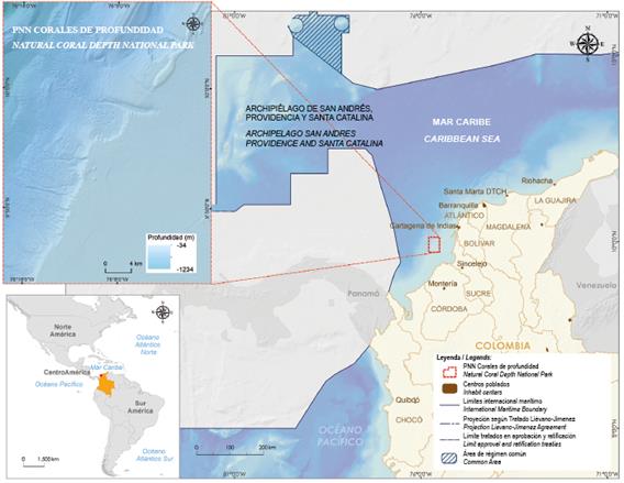
The PNNCP at the sea front of the departments of Bolívar, Sucre and Córdoba covers an area of 142,195.15 ha with depths ranging from 34 to 1234 m (Figure 1). It is located within the coordinates 9°43’16.591”- 10°7’30.277” N and 76°0’16.254”-76°17’41.091” W in the Magna-Sirgas West origin reference system (Resolution 339 of 2013), approximately 32 km from the nearest point on the mainland (Barú peninsula). The proximity of this park to other established protected areas, such as the Corales del Rosario and San Bernardo Natural Park (approximately 12 km) and the El Corchal Mono Hernández Sanctuary of Fauna and Flora (approximately 47.49 km), places it in an area where conservation efforts have been performed to ensure the functionality of the biodiversity levels that characterize the marine landscape.
The PNNCP is located in the Sinu Fold Belt tectonic terrain (Duque-Caro, 1979) formed by the interaction between the Caribbean oceanic plate and the South American continental plate. Taboada et al. (2000) propose the interaction between the Caribbean and South American plates as a very low angle subduction, whereas Cediel et al. (2003) prefer to interpret the interaction between these two plates as a collision in which one plate is forcefully overlapped upon the other (forced overthrusting). The Sinu Fold Belt extends to the west of the Sinu fault for approximately 500 km with an amplitude of 125 km. It is composed of sedimentary rock sequences that range from the Middle Eocene to the Late Oligocene (between 48 and 23 Ma) (Ingeominas, 2003).
Duque-Caro (1984) describes the Sinu Fold Belt as a sedimentary sequence approximately 8 km thick consisting mainly of turbidite and hemipelagic rocks from the Oligocene-Pliocene. The folds are frequently pierced by intrusions of over-pressed mud. On the other hand, Toto and Kellogg (1992) mention that the Sinú and San Jacinto Fold Belts (CDSSJ) form a sedimentary wedge approximately 12 km thick that was added to the South American margin during the Cenozoic. The wedge is characterized by a low topographic slope (≤2°) and abundant mud volcanism (Vernette et al., 1992). The wedge is bound to the northwest by the marginal fault of the southern Caribbean and to the southeast by the Romeral fault zone (Toto and Kellogg, 1992).
METHODOLOGY
A digital elevation model (Figure 2) with a resolution of 10 m per pixel was obtained from the bathymetric data collected between May 26 and June 5, 2015 in a campaign performed by the Maritime General Directorate - DIMAR (ANH-DIMAR convention 169-14). The Kongsberg EM-302 Multibeam system, installed on board the ship ARC Providencia, was used with the automated data collection equipment and the Seafloor Information System (SIS) software. The hydrography area of DIMAR (2015) used the CARIS HIPS and SIPS 8.1 software for processing, editing and data correction.
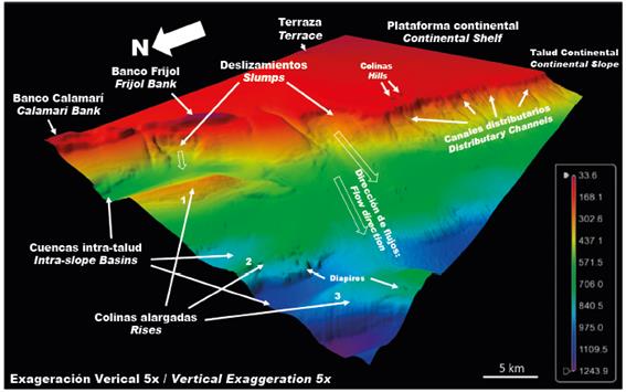
Figure 2 Digital elevation model of the PNNCP with the identification of some geoforms and geomorphological features. The depth scale is in meters.
The spatial analysis of the depth model was performed using the tools available in ArcGIS 10.3.1 software to generate hillshade and slope models (ArcGIS Toolbox - Spatial Analyst - Surface - Hillshade, Slope). This enabled the updating of some defined geoforms for the exploration area of the Fuerte Norte block (Invemar-ANH, 2008; Rangel-Buitrago and Idárraga-García, 2010) and the interpretation of geomorphological units and features in complementary areas. For the geomorphological classification, the guidelines established in the Coastal and Marine Ecological Classification Standard (FGDC, 2012) and the hierarchical structure of the national geomorphological classification proposals were followed (Carvajal-Perico, 2012; Gómez et al., 2012; Robertson et al., 2013). Finally, the relief shapes were named according to the nomenclature and standard definition of the IHO/ IOC (2008).
Morphological alignments were drawn from the slope classification (SCWG, 1998) as descriptive attributes of identified relief units and the hillshade model to visualize abrupt relief changes associated with the structural style of the area (Ordoñez-Aristizábal et al., 2009; Vinnels et al., 2010; Quintero, 2012). The geomorphological features were interpreted considering the tectonic or morphodynamic environment, the physiographic character and the possible origin of each geoform.
RESULTS
The PNNCP is located in the morphodynamic environment of a convergent active continental margin. It occupies approximately 65000 ha over the continental shelf (45%) and 77000 ha over the continental slope (55%). The slope break between both physiographic provinces in this sector was identified at depths between 150 and 170 m. This work includes the geomorphological mapping of the PNNCP (Figure 3) and describes 16 geomorphological units that conform the two physiographic provinces, indicating the possible associations between its origin and the geological processes such as uplift, erosion, sedimentation and mass movements.
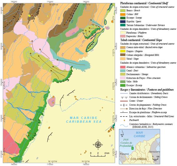
Continental platform
In the PNNCP, the continental shelf is between 34 and 150 - 170 m, where the break of the continental slope is located. It is flat to semi-flat with slopes <1°. Sediment Wave Fields are arranged on it with a south- east or north-west direction, possibly formed by deep currents or associated with different positive or negative forms that interrupt the homogeneity in the terrain. In the south-eastern area, regular depressions (pockmarks) may be related to occasional emanations of fluids or gases (Hovland and Judd, 1988). Within the platform, the following forms of relief were differentiated:
Units of structural origin: Banks: Located in the northeastern sector of the PNNCP is the so-called Frijol. It corresponds to an extension of the relief that defines the Tortuga shoal and Barú peninsula, which relates its origin with the structural character of the Colombian Caribbean margin. It is an ellipsoidal formation with a long axis of 8.2 km in the northeast-southwest direction and a short axis of 1.4 km. The relief corresponds to a bank with an elevated platform at 116 m between the depths of 34 to 150 m, and the top is a sloping terrace (0.5°). The bank is associated with distinguished features of greater detail such as scarps, of which the most pronounced is to the east with a slope of 25° versus 20° on the western side and channels in the middle of the bank with slopes close to 20°.
The southern end of the Calamarí bank is located in the northeastern corner of the PNNCP. The bank is elongated in the NE-SW direction, has an irregular appearance, low to moderate slopes, and encloses a basin 1 km wide within the platform. It is important to highlight the recent organic influence on the growth of the bank, which implies a geoform origin that was a combination of geological processes via structural lifting through mud domes and biotic processes via the colonization of coral formations.
Hills: In the central area of the PNNCP, there are two separate mounds with approximately 30 m in elevation protruding from a depressed area before the shelf breaks. They are related to diapirism formations of mud that can be colonized by organisms.
Scarps: These are areas with strong to steep slopes (>35°) in level jumps between continuous relief shapes; those associated with the Frijol and Calamarí banks stand out. The eastern scarp of the Frijol bank features an average slope of 25° and reaches values of 60°. It is slightly dissected with a saw-toothed edge toward the top. In the western scarp, the average slope is 16° with maximum values between 35 and 40°, and it is slightly dissected with a continuous and regular character. The scarps of the Calamarí bank feature strong to very steep slopes (16.5 to >45°), and its distribution is irregular due to the conformation of the relief. There is a scarp formed from a mass movement structure on the north-west side of the same bank.
Spurs: These are elongated shapes in the expression of the continental shelf. On the western side of the Frijol Bank towards the slope area, there is an elongation of approximately 1.5 km bound by moderate slopes and escarpments. The depth of its crest increases from 124 m at the point of contact with the bank to 173 m at the greatest reach of the slope.
Submarine Terraces: In the southeast area of the PNNCP, there is an irregular surface elevated 20 m from the seabed with an approximate area of 6000 ha, which ends in a slope of 20° towards the northwest side, whereas towards the east, its slope is nearly leveled (<1°) and ascending.
Units of denudational origin: Holes: These are slight landslides associated with old channels, such as those surrounding some mounds or hills. They are nearly leveled (<0.5°) in their center and are bound by escarpments with slopes that reach 20°.
Continental slope
The continental slope is the outlined area from the depths of 150 and 170 m, the approximate level where the continental shelf break occurs, and comprises the PNNCP area up to 1350 m corresponding to the maximum park depth. It is distinguished by gentle to moderate slopes that increase up to 10°. It extends through the width of the structures formed by the Sinu Fold Belt offshore.
Units of denudational origin: Submarine Fans: There is a fan on the south side of the PNNCP, corresponding to a semi-triangular shaped sedimentary deposit with a vertex in the moderate slope zone of the escarpment and opening toward the foot of the slope to the west. It indicates the occurrence of old submarine flows or channels.
Channels: Many channels are dispersed throughout the slope area in the southwestern part of the Frijol bank; the most pronounced is named Los Angeles (650 m wide). They are elongated features of varying depth in the form of grooves on the continental slope, sometimes associated with flow or slump structures. The slopes have strong grades (20°). Is remarkable the absence of channel extensions onto the platform, therefore, the sediment contributions from the coast are restricted.
Slumps: These areas are influenced by the flow of material on the seabed. The detachment surface is apparent in the upper slope and the deposit formed on the western slope. Its surface is irregular with waves towards the west.
Two large-scale slumps occur in the PNNCP. The first is located in the center of the PNNCP, with a slump crown 5.57 km wide. The escarpment slope is approximately 20° and is reduced to 2° following the slope direction of the continental slope. The slump extends more than 13 km and represents an elevation change of 575 m. The second slump is to the west of the Frijol bank with a crown 4.18 km wide. The escarpment slope has values between 15 and 20°. The slump flow is limited on the western side by one of the submarine structural elevations.
Scarps: Unlike the escarpment described on the continental shelf, the origin of the scarps on the slope is related to denudational events in zones with strong to steep slopes (> 35°) associated with areas of slope slumping. They appear from the continental shelf break descending towards the west. In the northern area of the PNNCP, they exhibit concave forms associated with slump crowns. On the south side exists a continuous escarpment that extends from the northeast to southwest over 22 km.
Debris Flows: These are deposits related to sediment flows from the gradient break between the shelf and slope. They are dissected by various channels and extend along the slope in the east - west direction to a depth of 880 m where they are bound by one of the submarine structural elevations and are dispersed northward into one of the intra-slope basins.
Valleys: These are areas of very gentle slope near submarine elevations, which probably favor the accumulation of sedimentary deposits and in which dykes are identified separating intra-slope basins or steeper slopes.
Units of structural origin: Rises: The activity of the Sinú Fold Belt formed by the compression between the Caribbean and South American plates has favored the structural lifting of the relief that conforms the seabed of the PNNCP. Three elevations are distinguished at depths of 305, 680 and 709 m (Figure 2), which are in descending depth from east to west.
Elevation 1, between 305 and 590 m, has a moderate to pronounced slope (8 - 35°) towards the east, and its lower part is a submarine valley. On the western side, the slope is gentle to strong (3 - 16.5°) descending towards a low slope to a flat area. Elevation 2, between 680 and 950 m, has a gentle slope (2°) to the east, protrudes approximately 20 m from the seabed and is bound by an intra-slope basin after a moderate to strong slope (between 8 - 18°) to the west. Elevation 3, between 709 and 1100 m, presents gentle to strong gradients (3 - 12°) on the eastern slope and strong to very strong (10 - 20°) gradients on the western slope, ending in an intra-slope basin with average depth of 1190 m. The PNNCP only covers a fraction of the rises, which continue to the north in the case of elevations 1 and 2, and continue to both the northeast and southwest of elevation 3.
Intra-slope Basins: These are located near the rises at the foot of the slumps, are low gradient areas that favor the accumulation of sediment contributed by slumps from the slope.
Diapirs: These are dome-shaped expressions of the terrain characteristic of the seabeds in the Sinú Fold Belt, both submarine and continental. They are associated with initial depressions and the growth of surface bulges. Six diapirs were identified within the PNNCP area; five in the northern area; three associated with slopes of submarine elevations; and two in the middle of the intra-slope basin at 730 and 790 m in depth. Two of the diapirs have a conical volcano appearance and crater formation. One diapir is located on the continental shelf approximately 4 m in elevation from the seabed and is located in the southern area of the PNNCP at 97 m in depth.
Geomorphological features and alignments
From the depth and hillshade models, geomorphological and geological features and alignments were identified and associated with the identified geoforms that are described below.
Submarine distributary channels: Three channels are located in the central area of the PNNCP, descending through the continental slope forming a channel with an average slope of 3° and an approximate length of 10 km in a southeast - northwest direction.
Flow directions: They were outlined to mark the displacement trend of mass movements related to submarine slump deposits or to the channel geoform. In general, they have a direction from east to west with a turn towards the north-west.
Terraced escarpment: These outline the level jumps on the continental shelf from depths of 111 to 121 m on slopes of 10°.
Slump crowns: They correspond to breaks in the platform with a depth of 150 to 170 m, with concave shapes in plant associated with escarpments and slump deposits.
Crater: Two openings of mud volcanoes were identified near the park. The first is associated with a diapir on the western slope of a submarine elevation (76°13’11.687”W; 10°5’34.591”N) at a depth of 835 m, and it has an ellipsoidal shape with 280 m on its long axis and 180 m on its short axis. The other is associated with the diapir near the top of the deepest submarine elevation of the park (76°17’14.165”W; 10°4’38.317”N) at 778 m in depth with a circular shape and a diameter of 120 m.
Faults: These correspond to northeast - southwest alignments that mark the slope change between elevations and adjacent basins or valleys. They include the intermediate channel edges at the top of the Frijol bank with the same structural direction.
Fold crests: These are elevation axes associated with uplifts of the tertiary rock basement of probable anticlinal type and in the same direction as the northeast - southwest structural alignments.
DISCUSSION
The PNNCP has important morphological features within the continental shelf and slope of the Colombian Caribbean. The relief elements identified in the PNNCP are related to the Sinu Fold Belt with marked uplift structures and well-differentiated basins and channels.
Because the seabed morphology allows for the identification of biological communities or assemblages, the descriptions of these geoforms in the PNNCP become surrogates for biodiversity in the absence of biological information, while more detailed studies are performed (Harris et al., 2008; Harris and Whiteway, 2009). The detailed bathymetric and geomorphological information will determine the probable distributions of the different deep-water coral species present in the PNNCP, especially Madracis myriaster. This community is “rare” in the Caribbean region and the world, giving it a higher value in terms of conservation priority and worldwide research (Alonso et al., 2015).
The geomorphological mapping corroborated that one of the most relevant and most interesting features for the investigation is the Frijol bank. This is due to its geological origin and morphological characteristics associated with the growth of coral formations in areas of hard substrates. Bordering the Frijol bank, there is a slump corona with its flow directed to the north-west. The identification of such structures poses a potential threat to the bank’s structure. A second slump identified in the central area of the PNNCP is of interest in the analysis of the environmental variations that affect it.
On the slopes of the structural elevations were delimited domes associated with diapirs, formed possibly by the expulsion of over-pressured mud in areas of possible Tertiary formations. In some cases, they have been formed volcanic cones that represent areas of sediment flow in the seabed with important contributions for habitat identification. In the southeast area of the PNNCP were identified pockmarks as important gas ejection markers (Hovland and Judd, 1988). These forms are present in other areas of the continental shelf and have been little studied in Colombia for the analysis of benthic communities.
The area of the PNNCP with depths less than 100 m is approximately 295,000 ha, and its exploration requires activities such as Rebreather autonomous diving. These areas are contained in the Frijol bank, with mounds of probable diapiric origin in the central area and in the southeastern sector of the park at depths of approximately 50 m with an irregularly surfaced terrace and a structural channel.
Among the PNNCP were selected areas of interest based on the identified geomorphology. Depths greater than 100 m required geophysical acquisition methods or remotely operated vehicles (ROVs) to characterize and map the ecosystems in which deep-water coral communities are located in geoforms identified by their potential for association with benthic communities. These geoforms are comprised of elevations and submarine channels, escarpments, diapirs and pockmarks, which are recognized by the existence of significant ecosystems in the seabed (Hovland and Judd, 1988; Harris, 2012).
The geomorphological classification presented here was based on the spatial analysis of the bathymetric model with a resolution of 10 m. The interpretation of high-resolution seismic records and classification from the backscatter (acoustic response associated with the composition and shape of the seabed) would support the morphogenetic evolution of the PNNCP and validate the description of the current geomorphological units. The acquisition of bathymetric information with a higher resolution (<4 m) would improve the detail of the classification. Periodic bathymetric surveys would contribute to the recent evolutionary analysis of the PNNCP and the risk assessment of natural hazards.
In the summary document for the declaration of the marine protected area containing deep-water corals, one of the justifications lists the research interest for studies to map properly the coralline formations using non-invasive methods that would help to understand the patterns of ecological connectivity between deep-water benthic communities and shallow ecosystems (Invemar - Parques Nacionales, 2012). This would help to improve the design and planning for management of the marine protected network areas in the Colombian Caribbean to prevent the isolation of populations and promote the flow of matter and energy between different habitats and ecosystems (Invemar - Parques Nacionales, 2012).
This study was presented as a knowledge base of the current scenario to establish the association of geomorphology with the presence of benthic communities on the continental shelf and slope. Given the limited knowledge of the PNNCP and the need to understand how the key ecological processes are influenced by the geomorphological features, it is important to increase the description detail of the submarine relief, the morphological processes and the study of oceanography (currents). The cartographic production of these geomorphologies will allow the identification of locations of particular interest to collect biological samples and integrate spatial information to identify benthic habitats for tropical areas such as the central Caribbean region, which are very scarce (Madden et al., 2008; FGDC, 2012).
CONCLUSIONS
This cartography is a contribution to the detailed knowledge of the Colombian Caribbean seabed. The use of new technologies for the acquisition of submarine information allows us to identify or complement units and features of the terrain with greater precision. For this purpose, its characteristics (size and slopes) have been described following published standards and national nomenclature proposals and were considered within the tectonic framework to determine their origin.
This study was an initial approximation to the geomorphological description of PNNCPusing multibeam bathymetry. The results published here determined the site selections that, due to their geomorphological characteristics, are possible locations of the ecosystem associated with deep-water coral communities. The following sites were considered for the investigation: the Frijol and Calamarí banks, the Los Angeles channel, the rise at 300 m depth, the hills in the south-central area of the PNNCP and segments of the continental slope escarpment (Invemar, 2015). It is necessary to continue the acquisition of geophysical information in the area to corroborate the origin and distribution of the geoforms presented here.
ACKNOWLEDGMENTS
This study was performed within the framework of the project “Characterization of the coralline communities of the Corales de Profundidad Natural National Park in the Colombian Caribbean, an approach to the conservation of their biodiversity” by INVEMAR, PNN and the University of Manchester, and it is co-financed by the National Hydrocarbons Agency. Thanks to the reviewers and the geographer M. González for their valuable comments and C. Ricaurte-Villota, D. Alonso and C. Cedeño-Posso for the support and interest in the research development.
REFERENCES
Alonso, D., M. Vides, C. Cedeño, M. Marrugo, A. Henao, J.A. Sánchez, L. Dueñas, J.C. Andrade, F. González y M. Gómez. 2015. Parque Nacional Natural Corales de Profundidad: descripción de comunidades coralinas y fauna asociada. Serie Publicaciones Generales Invemar, 88. 20 p. [ Links ]
Carvajal-Perico, J.H. 2012. Propuesta de estandarización de la cartografía geomorfológica en Colombia. Serv. Geol. Col., Bogotá. 83 p. [ Links ]
Cediel, F., R. Shaw and C. Cáceres. 2003. Tectonic assembly of the northern Andean Block. En: Bartolini, C., R. Buffler y J. Blickwede (Eds.). The circum-Gulf of Mexico and Caribbean: Hydrocarbon habitats, basin formation and plate tectonics. Am. As. Petr. Geol. Mem., 79: 815-848. [ Links ]
DIMAR. 2015. Levantamiento hidrográfico mar Caribe colombiano. Polígono 2A, Contrato No. 169-2014. MDN-DIMAR-ANH. 13 p. + Anexos. [ Links ]
Duque-Caro, H. 1979. Major structural elements and evolution of northwestern Colombia. Am. As. Petr. Geol. Mem., 29: 329-351. [ Links ]
Duque-Caro, H. 1984. Estilo estructural, diapirismo y episodios de acrecimiento del terreno Sinú-San Jacinto en el noroccidente de Colombia. Bol. Geol. Ingeominas, 27(2), 29 p. [ Links ]
FGDC. 2012. Coastal and marine ecological classification standard. Federal Geographic Data Committee. 258 p. [ Links ]
Gómez, J., J.H. Carvajal y J. Otero. 2012. Propuesta de estandarización de los levantamientos geomorfológicos en la zona costera del Caribe colombiano. Convenio Especial de Cooperación Colciencias - Gobernación del Magdalena - Invemar. Serie Publ. Espec., 110 p. [ Links ]
Harris, P.T. 2012. Seafloor geomorphology - Coast, shelf, and abyss: 109-155. In: Harris, P.T. and E.K. Baker (Eds.). Seafloor geomorphology as benthic habitat. Elsevier. 947 p. [ Links ]
Harris, P.T and T. Whiteway. 2009. High seas marine protected areas: Benthic environmental conservation priorities from a GIS analysis of global ocean biophysical data. Oc. Coast. Manag., 52: 22-38. [ Links ]
Harris, P.T., A.D. Heap, T. Whiteway and A. Post. 2008. Application of biophysical information to support Australia's representative marine protected area program. Oc. Coast. Manag., 51(10): 701-711. [ Links ]
Harris, M. and A.G. Judd. 1988. Seabed pockmarks and seepages: Impact on geology, biology and marine environment. 293 p. [ Links ]
IDEAM, IGAC, IAvH, Invemar, I. Sinchi e IIAP. 2007. Ecosistemas continentales, costeros y marinos de Colombia. Inst. Hidrol., Meteorol. Est. Amb., Inst. Geogr. Agustín Codazzi, Inst. Invest. Rec. Biol. Alexander v. Humboldt, Inst. Invest. Amb. Pac. John v. Neumann, Inst. Invest. Mar. Cost. José Benito Vives De Andréis e Inst. Amaz. Invest. Cient. Sinchi. Bogotá, 276 p. + 37 hojas cartográficas. [ Links ]
Ingeominas. 2003. Geología de los Cinturones Sinú-San Jacinto. Planchas 50 Puerto Escondido, 51 Lorica, 59 Mulatos, 60 Canalete, 61, Montería, 69, Necoclí, 70 San Pedro de Urabá, 71 Planeta Rica, 79 Turbo, 80 Tierralta. Escala 1:100.000. Memoria explicativa por Geotec Ltda. 225 p. [ Links ]
International Hydrographic Organization- Intergovernmental Oceanographic Commission. 2008. Normalización de las formas del relieve submarino. Bur Hidrogr. Internal, 32 p. [ Links ]
Invemar. 2015. Caracterización de las comunidades coralinas del parque nacional natural corales de profundidad en el Caribe colombiano: una aproximación a la conservación de su biodiversidad. Informe Técnico Final. INVEMAR-PNN-U. Manchester-ANH, Santa Marta. 127 p. + Anexos. [ Links ]
Invemar-ANH. 2008. Especies, ensamblajes y paisajes de los bloques marinos sujetos a exploración de hidrocarburos. Informe técnico final, Santa Marta, 461 p. + Anexos. [ Links ]
Invemar - Parques Nacionales. 2012. Elaboración de documento síntesis como insumo principal para la declaratoria de áreas marinas protegidas con presencia de bancos de corales de profundidad en el Caribe colombiano. Documento técnico de consultoría, Santa Marta. 97 p. [ Links ]
Lutz, S.J. and R.N. Ginsburg. 2007. State of deep coral ecosystems in the Caribbean region: Puerto Rico and the U.S. Virgin Islands: 307-363. In: Lumsden S.E., T.F. Hourigan, A.W. y G. Dorr (Eds.). The state of deep coral ecosystems of the United States. NOAA Techn. Mem., CRCP-3. [ Links ]
Madden, C, K. Goodin, B. Allee, M. Finkbeiner and D. Bamford. 2008. Coastal and marine ecological classification standard: Version III. NOAA and Nature Serve. 77 p. [ Links ]
Ordoñez-Aristizábal, C., A.L. Ferrari y G.C. Silva. 2009. Control neotectónico del diapirismo de lodo en la región de Cartagena, Colombia. Invest. Des., 8(1): 42-50. [ Links ]
Quintero, J.D. 2012. Interpretación sísmica de volcanes de lodo en la zona occidental del abanico del Magdalena. Trabajo de grado Geología, Univ. EAFIT, Medellín. 71 p. [ Links ]
Rangel-Buitrago, N. y J. Idárraga-García. 2010. Geología general, morfología submarina y facies sedimentarias en el margen continental y los fondos oceánicos del mar Caribe colombiano. 22-59. En: INVEMAR (Eds.). 2010. Biodiversidad del margen continental del Caribe colombiano. Serie Publ. Espec. Invemar 20, 458 p. [ Links ]
Reyes, J., N. Santodomingo, A. Gracia, G. Borrero-Pérez, G. Navas, L.M. Mejía-Ladino, A. Bermúdez and A.M. Benavides. 2005. Southern Caribbean azooxanthellate coral communities off Colombia. 309-330. In: Freiwald, A. and Roberts J.M. (Eds.). Cold-water Corals and Ecosystems. Springer Verlag Berlin Heidelberg. [ Links ]
Ricaurte, C., J.G. Domínguez, G. Mayo, C.A. Andrade, H.M. Ospina y A.J. Gutiérrez. 2004. Nota sobre algunos rasgos morfológicos de los bancos de Salmedina. Bol. Cient. CIOH, 22: 64-76. [ Links ]
Robertson, K.G., O. Jaramillo y M.A. Castiblanco. 2013. Guía metodológica para la elaboración de mapas geomorfológicos a escala 1:100.000. IDEAM, Bogotá. 88 p. [ Links ]
Santodomingo, N., J. Reyes, A. Gracia, A. Martínez, G. Ojeda and C. García. 2007. Azooxanthellate Madracis coral communities off San Bernardo Islands (Colombian Caribbean). Bull. Mar. Sci., 81(Sup. 1): 273-287. [ Links ]
SCWG - Soil Classification Working Group. 1998. Chapter 18: Landform classification. The Canadian System of Soil Classification. Agric. and Agri-Food Can. Publ., 1646: 161-178. [ Links ]
Taboada, A., L.A. Rivera, A. Fuenzalida, A. Cisternas, H. Philip, H. Bijwaard, J. Olaya and C. Rivera. 2000. Geodynamics of the northern Andes: Subductions and intracontinental deformation (Colombia). Tectonics, 19(5): 787-813. [ Links ]
Toto, E. and J. Kellogg. 1992. Structure of the Sinú-San Jacinto fold belt. An active accretionary prism in northern Colombia. J. SA Earth Sci., 5(1): 211-222. [ Links ]
Urriago, J.D., N. Santodomingo y J. Reyes. 2011. Formaciones coralinas de profundidad: criterios biológicos para la conformación de áreas marinas protegidas del margen continental (100-300 m) en el Caribe colombiano. Bol. Invest. Mar. Cost., 40(1): 89-113. [ Links ]
Vernette, G., A. Mauffret, C. Bobier, L. Briceno and J. Gayet. 1992. Mud diapirism, fan sedimentation and strike-slip faulting, Caribbean Colombian Margin. Tectonophysics, 202: 335-349. [ Links ]
Vinnels, J., R. Butler, W. McCaffrey and P. Douglas. 2010. Depositional processes across the Sinú accretionary prism, offshore Colombia. UK Mar. Petr. Geol., 27: 794-809. [ Links ]
APPENDIX
Glossary of terms used for the denomination of geomorphological units:
Bank: Isolated elevation or a large group of elevations on the seafloor where the depth is relatively shallow but usually sufficient for safe surface navigation.
Channel: A long depression with a continuous slope. It is common in fans and abyssal plains and usually flanked by levees on both or one of its sides.
Continental slope: A decline to great depths extending from the edge of the platforms to the point where there is a general decrease in slope.
Continental shelf: An area adjacent to a continent (or surrounding an island) extending from the low water mark to a depth where there is usually a marked increase in slope towards the ocean depths.
Debris flows: Non-channeled relief formed by the movement of material through a slope.
Diapirs: Anticlinal structure in which the very ductile and mobile innermost layers, containing evaporites or shales (clays with salts), pierce the outer layers formed by more competent rocks.
Fan: A fan-shaped sedimentary body with relatively smooth contours extended in slope from the mouth of a submarine canyon or submarine canyon system.
Hill: Isolated elevation or group of elevations that are smaller than an underwater mound.
Holes: Small local depressions that are often steep on the sides and located on the seafloor.
Intra-slope basins: A depression on the seabed of variable length or less equidimensional on the floor.
Rises: Wide ocean floor elevation that rises steadily and gradually in most cases.
Scarp: A submarine slope that is characteristically linear, very steep and long and divides flat or gently sloping seabed areas.
Slump: Gravitational mass movement of a significant volume of rock fragments due to a balance loss in an unstable material.
Spur: A secondary relief or ridge projecting from a larger morphological feature.
Terrace: A relatively flat, horizontal or slightly inclined area (or group), sometimes long and narrow, bound by an upward slope on one side and a downward slope of higher gradient on the opposite side.
Valley: A wide and relatively shallow depression with a seabed that generally features a continuous gradient. Usually this term is not used for features that exhibit the characteristics of a canyon along significant sections of its route.
Received: April 14, 2016; Accepted: August 18, 2017
 Este es un artículo publicado en acceso abierto bajo una licencia Creative Commons
