


Services on Demand
Journal
Article
 text in
  Spanish (pdf)
 Article in xml format
 Article references
 Send this article by e-mail
Indicators
-
 Cited by SciELO
 -
 Access statistics
Related links
-
 Cited by Google
 -
 Similars in
SciELO
Similars in
SciELO -
 Similars in Google
Share

 Permalink
Boletín de Investigaciones Marinas y Costeras - INVEMAR
Print version ISSN 0122-9761
Bol. Invest. Mar. Cost. vol.48 no.1 Santa Marta Jan./June 2019 Epub Sep 13, 2019
https://doi.org/10.25268/bimc.invemar.2019.48.1.760
Research Articles
Definition of Environmental Units of Analysis: alternative method as a basis for environmental zoning of marine-coastal ecosystems
1 Instituto de Investigaciones Marinas y Costeras - INVEMAR. Calle 25 No. 2-55, Playa Salguero, Santa Marta D.T.C.H., Colombia. leonardo.ospino@invemar.org.co
2 Instituto de Investigaciones Marinas y Costeras - INVEMAR. Calle 25 No. 2-55, Playa Salguero, Santa Marta D.T.C.H., Colombia. angela.lopez@invemar.org.co
The purpose of environmental zoning is to improve environmental management and the sustainable management of the coastal and marine ecosystems. This zoning can be performed by using methods such as participative zoning, COLMIZC, and the method used in the Decision Support System (DSS) called "Software MARXAN". The methods present advantages and disadvantages. However, they all require an input of detailed primary or secondary data, and biotic and physical information regarding the ecosystem. Thus, this study employs a method that was the result of the analysis of different methods, and that enables suitable environmental zoning of the marine-coastal ecosystem (e.g. mangroves, seagrasses, coral reef, etc.) without detailed biophysical information. Its main characteristic is the definition Environmental Units of Analysis (EUA), as units that have been considered as homogenous regions that can be defined from different aspects such as ecosystem size or distribution, and socioeconomic and cultural aspects (Ospino-Sepulveda et al., 2017b). Having defined the EUA, it is possible to map specific ecosystem and consider other important environmental elements, which sometimes are not considered important when using other methods. As a result of this work, 14 EUA were obtained in La Guajira and 14 EUA in Chocó for marine-coastal areas in the Colombian Caribbean. The application of socio-economic, socio-cultural and biotic criteria to EUA defined zones for protection, restoration, and development of sustainable economic activities. We hope that the method adopted in this work will, in the future, be considered as an alternative for the environmental zoning of ecosystems marine-coastal areas.
KEYWORDS: Environmental Units of Analysis (EUA); Environmental zoning; Planning; Management; Marine-coastal ecosystems; Socioeconomic and cultural aspects
El ordenamiento ambiental y el manejo sostenible de los ecosistemas marino-costeros son la finalidad de la zonificación ambiental que se realiza a partir de la implementación de métodos como el COLMIZC, la zonificación participativa y aquella que se emplea con el Sistema Soporte de Decisión (SSD) también conocido como "Software MARXAN". Estos métodos presentan ventajas y desventajas; sin embargo, todas ellos tienen algo en común: la necesidad de incluir información detallada, primaria o secundaria, del componente biótico y físico del ecosistema a zonificar. En ese sentido, para el presente trabajo se adapta un método, a partir de otros ya existentes, para realizar una apropiada zonificación ambiental de un determinado ecosistema marino-costero (como, por ejemplo, manglar, pastos marinos, corales, entre otros), sin contar con información detallada biofísica. Tiene como principal característica la definición de Unidades Ambientales de Análisis (UAA), las cuales se consideran como regiones homogéneas que pueden definirse desde diferentes aspectos que van desde el tamaño o distribución del ecosistema, hasta los socioeconómicos y culturales (Ospino-Sepulveda et al, 2017b). A partir de la definición de UAA es posible zonificar un ecosistema específico, considerando como significativos, otros elementos o generalidades ambientales que muchas veces en otros métodos no poseen gran importancia. Como resultado de la aplicación del método alternativo se obtuvieron 14 UAA para la zona marino-costera del departamento de La Guajira y 14 UAA para el Chocó, en el Caribe colombiano; la aplicación de criterios socioeconómicos, socioculturales y bióticos sobre las UAA definieron zonas para la protección, recuperación y desarrollo de actividades económicas sostenibles. Se espera que el método por definición de UAA sea considerado como una alternativa para realizar la zonificación ambiental de un ecosistema específico presente en áreas marino-costeras.
PALABRAS CLAVES: Unidades Ambientales de Análisis (UAA); Zonificación Ambiental; Ordenamiento; Ecosistemas marino-costeros; Aspectos socioeconómicos y culturales
INTRODUCTION
Environmental zoning is the process by which geographic areas are ordered by dividing them into spatial units according to similarities in their biotic, physical or sociocultural components. Specific criteria are applied to group these units in order to establish their requirements for management and conservation (Alonso et al., 2003). For coastal areas, zoning must include a social perspective given their status as a public good. This is not the case in fully continental areas (Cicin-Sain and Knecht, 1998; Clark, 1998). Most studies use participatory zoning methods (López et al., 2013) and "MARXAN Software", among others, to design the environmental zoning of a region in which several ecosystems are found (Watts et al., 2009). These studies use the biotic and physical components of the study area as the main source of information, but these methods can be somewhat limited when they do not have enough data or detailed spatial and biophysical information of the study area (Ardron et al., 2013).
In Colombia, the "National Environmental Policy for the Sustainable Development of Oceanic Spaces and Coastal and Insular Zones of Colombia - PNAOCI (acronym in Spanish)" was implemented to address the processes of integrated management and sustainable development of oceanic spaces and coastal zones. The policy became the basis for the planning and integrated management of these areas (Ministry of the Environment, 2000). In the same line, INVEMAR elaborated the "Methodological Guide for the Integrated Management of Coastal Zones in Colombia" (Alonso et al., 2003), with its three manuals that proposes a process to address planning in coastal zones, including the method for the environmental zoning of a marine-coastal space or territory called Colmizc methodology.
The Colmizc methodology promoted in the "Methodological Guide for the Integrated Management of Coastal Zones in Colombia" (Alonso et al., 2003), proposes the development of environmental zoning based on the homogeneous definition of ecological units of the landscape (EUL, which in this case would be the EUA), mainly from the physical, biotic (geomorphology and coverage), and use aspects. Despite this, there may sometimes not be enough biophysical information with which to define the UEP. Considering the above, the need arises to propose an alternative method for the definition of the EUA, with which to carry out the environmental zoning process.
This study presents an adapted method for the environmental zoning of a certain marine-coastal ecosystem, homogeneously defining Environmental Units of Analysis (EUA) based on socioeconomic aspects and the size or distribution of the ecosystem. However, this method analyzes the biotic information that is available of some sectors of the study area to be used in the zoning criteria. The relevance of adapting this method is that it could be applied to other coastal and marine geographical areas, where limited biophysical information is presented to define units of analysis in environmental zoning processes.
The case study for this paper was based on the seagrass ecosystem located in the marine-coastal zone of the departments of La Guajira and Chocó in the Colombian Caribbean. However, this method can be applied to zoning other marine-coastal ecosystems, such as mangroves, corals, and beaches, among others.
STUDY AREA
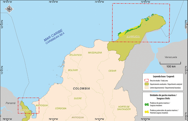
The study area covered two sectors of the Colombian Caribbean; one located in the marine-coastal area of the department of La Guajira and the other in the marine-coastal area of the department of Chocó (Figure 1). The department of La Guajira is geographically located in the extreme north of Colombia and South America; its marine-coastal zone is home to several ecosystems, but the most distinctive, with more than 85%, are the seagrass meadows represented by 55,376.93 ha. They include a mixed coverage (macroalgae and pastures) of approximately 1,047.93 ha and a potential area of presence of seagrass is approximately 81,755.23 ha (Gómez-López et al., 2014) where they are present. The Chocó department, on the other, located in the Colombian northeast, borders in the north, in its Caribbean region, with Panama. In this area, seagrasses are found discontinuously due to the entry of freshwater bodies and the narrow continental shelf. The representation of this ecosystem with respect to the total area in the country is 0.40%, characterized by 260.49 ha of seagrasses, a mixed coverage (macroalgae, corals) of approximately 90.75 ha, and a potential area of presence of seagrass is approximately 46.55 ha (Gómez-López et al., 2014). Both sectors are influenced by anthropogenic pressures coming mainly from activities related to tourism, mining and artisanal fishing, which, in one way or another, affect or deteriorate the seagrass ecosystem present in the study area.
MATERIALS AND METHODS
The Colmizc methodology (Alonso et al., 2003) was reviewed and analyzed and later contrasted with the information available for the study area. The analysis identified that for the area the information available from the biotic and physical component was not enough or detailed enough to define the EUL. Given the information gaps identified, we had to rethink the methodology and find an alternative method to continue with the environmental zoning of the seagrass ecosystem. In so doing, the proposal of the Colmizc methodology for the definition of the EUL was adapted based on biophysical and socioeconomic information, specifically drawing on socioeconomic aspects and the size and distribution of the ecosystem to define the EUA.
In La Guajira's marine-coastal area, the seagrass ecosystem is very extensive and continuous, making it difficult to define the EUL because there was no biotic information related to composition, structure or function of the entire seagrass meadow. For this reason, the socioeconomic information related to the uses or activities that present or could exert tension on the seagrasses in this area (Figure 2), was grouped by proximity and direct influence on the ecosystem and used to distribute the area in different sectors or polygons, which become the EUA to be zoned.
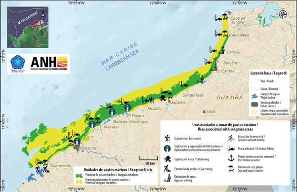
Figure 2 Uses associated with the pressure that the seagrass ecosystem may suffer in the marine-coastal area in La Guajira, Colombian Caribbean. Source: adapted from Ospino-Sepulveda et al. (2017a).
For Chocó's marine-coastal area located in the colombian Caribbean, the size and distribution of seagrass meadows is different, since they are distributed in small patches throughout the area; thus, each patch of seagrass could be managed as a EUA without having to divide it. However, the socioeconomic information pertaining to this area was also analyzed in order to find out which anthropic pressures this ecosystem was subject to in the different sites (Figure 3).
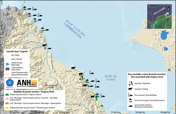
Figure 3 Uses associated with the pressure that the seagrass ecosystem may suffer in the marine-coastal zone of Chocó, Colombian Caribbean. Source: Adapted from Ospino-Sepulveda et al. (2017a).
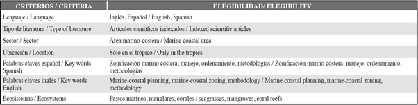
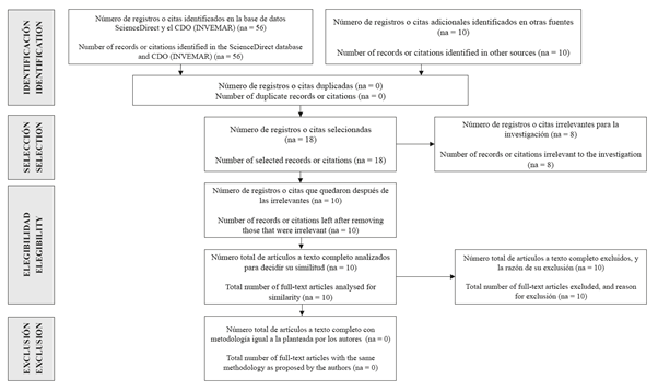
At the same time, a systematic review was carried out to verify that the method used is not documented in other studies. This review was carried out by adapting the PRISMA (Preferred Reporting Items for Systematic Reviews and Meta-Analyses) methodology (Sierra-Correa and Cantera, 2015), which helps to improve the integrity of systematic reviews (Hutton et al., 2016). In this sense, seven criteria were selected to carry out the bibliographic search. These are presented in Table 1.
Table 1 Search criteria for scientific articles that use a methodology equal or similar to the one proposed in this study.
This search was carried out in the documentation center of the Institute of Marine and Coastal Research (Invemar) and the database of scientific journals ScienceDirect. As a result, we found 66 indexed scientific articles that included the selected criteria. We then proceeded to review the articles found to see which of them proposed or employed an equal methodology for the environmental zoning of a single marine-coastal ecosystem (see Figure 4).
RESULTS AND DISCUSSION
In order to advance in any environmental zoning process, spatial units have to be defined as a basis to allow an initial differentiation, areas on which criteria will later be applied to define management areas (Etter, 1991; Alonso et al., 2003; Rodrigues and Lima, 2013; Mangubhai et al., 2015). For the definition of spatial units of analysis, several methods use the basis of geomorphology, coverage, and uses (Etter, 1991; Alonso et al., 2003), either to zoning landscapes at a wide scale or specific ecosystems. Given that specific ecosystems generally include a single geoform and a general type of cover (e.g. mangrove forest, seagrasses), it may be important to have more information in terms of composition, structure and function, to help define more detailed spatial units. For example, Van Thang (2014) refers to the functional zoning of seagrasses in Vietnam, using criteria such as habitat type and connectivity, among others. However, socio-economic are relevant to include a management approach based on ecosystem stewardship and associated uses.
Although it may be useful to have more detailed units of analysis, given the limited biotic information that can be used for differentiation and considering that environmental zoning is a management tool, in this case of the ecosystem, it is worth using the management approach of the uses that can or are affecting the ecosystem and the size or distribution of the ecosystems, without this limiting the inclusion of more detailed biotic variables in the future; for example, those related to composition, structure and function.
In the case of the present study, the socioeconomic information available, and the knowledge of the size and distribution of the ecosystem, made it possible to sectorize the areas of seagrasses according to the uses that are or could exert pressure on the ecosystem, and according to the extension and location of the seagrasses. This was an adaptation to what was proposed by Etter (1991) regarding the ecological units of the landscape, which has subsequently been used in different processes of environmental zoning, as is the case with the Colmizc methodology (Alonso et al., 2003).
Applying this alternative method, 14 EUA were obtained for the marine-coastal zone in La Guajira (Figure 5) and 14 EUA for the Chocó (Figure 6) in the Colombian Caribbean.
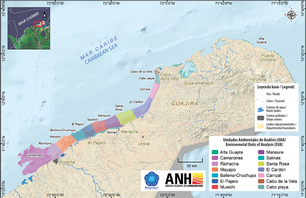
Figure 5 Environmental Units of Analysis (EUA) defined for the marinecoastal area of La Guajira. Source: Adapted from Ospino-Sepulveda et al. (2017b).
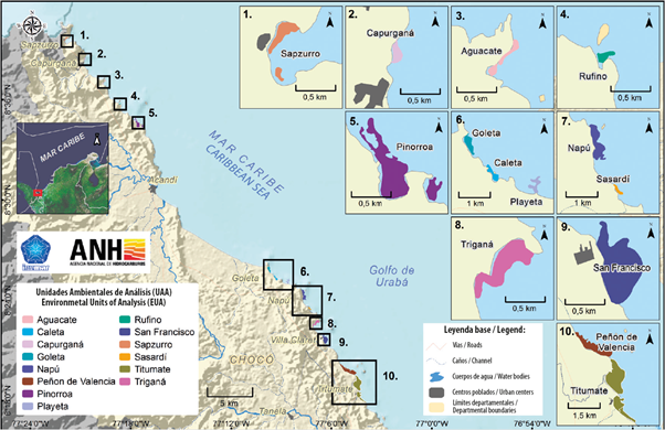
Figure 6 Environmental Analysis Units (USA) defined for the Chocó coastal-marine zone in the Colombian Caribbean. Source: Adapted from Ospino-Sepulveda et al. (2017b).
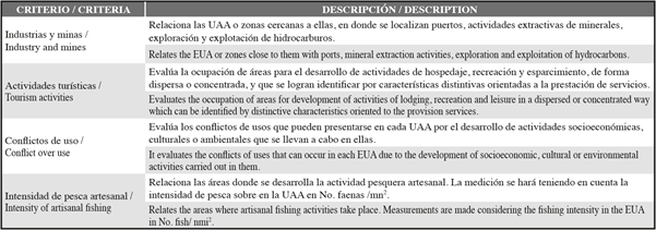
After having defined the EUA, criteria were formulated based on technical and scientific information that guided the environmental zoning process in each EUA. These criteria were constructed with information from the socioeconomic (Table 2), sociocultural (Table 3) and biotic (Table 4) components. The latter, with information on biotic elements that was available from only seven EUA, of the 27 that were defined for the entire study area.
On the other, from the biotic component, there were data related to the genetic characteristics of the seagrass ecosystem. Which were not constituted as a criterion due to the lack of detailed information about this subject for the entire study area. However, for some areas (particularly Cabo de la Vela) it was important to consider this variable for differentiating areas in the environmental zoning, with unique genetic characteristics.
As a result of this process, an environmental zoning proposal was generated for the two zones, and is presented in Figure 7 and Figure 8.
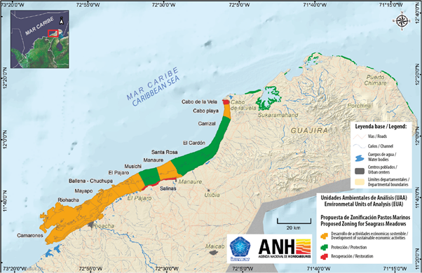
Figure 7 Map of the proposed zoning of seagrasses in the marine-coastal zone of La Guajira using the EUA definition method. Source: Adapted from Ospino-Sepulveda et al. (2017b).
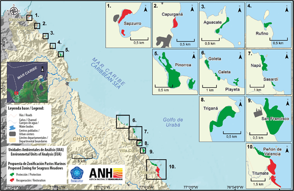
Figure 8 Map of the proposed zoning of seagrasses in the marine-coastal zone of Chocó Caribe using the EUA definition method. Source: Adapted from Ospino-Sepulveda et al. (2017b).
The results of the marine-coastal zone of La Guajira in the “Protection” category were five EUA, which correspond to Musichi, Santa Rosa, El Cardón, Carrizal and Alta Guajira, in which the influence of socioeconomic activity is less intense. Two EUA resulted from the "Restoration" category. One of them corresponds to Salt flats, greatly influenced by the mining activities in the Musichi and Manaure salt flats, and the other corresponds to Cabo de la Vela, because of the influence of tourism and fishing activities. Also, given the state of the seagrass ecosystem and the genetic importance of this population, it is recommended that they be restored so that they can be included in the "Protection" category in the future.
Finally, there are seven EUA in the "Development of sustainable economic activities" category. These are: Camarones, Riohacha, Mayapo, Ballena-Chuchupa, El Pájaro, Manaure and Cabo Playa, in which socioeconomic activities are more notorious, and in some of them they are performed directly on the ecosystem. Also, under this category is the EUA Cabo Playa which, according to the latest research, does not show presence of seagrasses, but does show presence of other strategic habitats, such as coral formations, Gorgonacea, and rhodolith and calcareous algae, that currently have not been mapped.
In this regard, in the marine-coastal zone of Chocó (Caribbean), 11 EUA were obtained within the "Protection" category (Aguacate, Rufino, Pinorroa, Goleta, Caleta, Playeta, Napú, Sasardí, Triganá, San Francisco and Peñón de Valencia). In these areas, the pressure on the seagrass ecosystem by socioeconomic and cultural activities is very low: In the "Restoration" category, as a result, was obtain three EUA as Capurganá and Sapzurro, in which mass tourism is deteriorating the seagrass ecosystem. The other EUA under this category is Titumate, in which the ecosystem is severely affected by livestock activities, specifically, the use of ferry crossing for livestock transport. Finally, no areas were recorded under the "Development of sustainable economic activities" category, which is very important to highlight, on the one hand because it reveals the reality of the area, which is not subject to any intensive socioeconomic activities that can affect or deteriorate the ecosystem, and, on the other, given that the ecosystem is distributed in small patches, the area is susceptible to being affected in all its extension.
CONCLUSIONS
The adaptation of this method to define EUA - is the basis for conducting an environmental zoning procced-this method has advantages over others in not requiring detailed (primary or secondary) information from the biotic and physical component to define the units of analysis of the ecosystem to be zoned. Also, general biophysical information from the study area can be incorporated into the zoning process. In this respect, using socio-economic information as the main source for EUA definition when the size or distribution of the ecosystem is different made it possible to differentiate areas of analysis based on the uses and activities that exert or may exert pressure on seagrasses or other ecosystems, without having to rely on specific information on biotic or ecological attributes in order to be able to separate these areas.
On the other hand, it should be pointed out that all the socioeconomic information used can be spatialized for analysis, both in defining the EUA and for constructing the environmental zoning criteria, which allows a broad vision of those aspects that may influence the management and planning of the study ecosystem.
Finally, it is important to point out that seagrasses are shown to be dynamic ecosystems, which can naturally increase or decrease their coverage over time (Millán et al., 2016). This implies that the definition of sectors or polygons for analysis is different from that often related to ecosystem structure, composition and function (Van Thang, 2014), and revolves around how externalities can affect or change it. However, the above does not mean that in order to improve ecosystem management, research and monitoring efforts can be strengthened so that more and better information can be provided regarding biotic attributes or aspects such as genetics, so as to differentiate areas and propose management measures that are more appropriate and in line with ecosystem dynamics.
ACKNOWLEDGEMENTS
The authors would like to thank Instituto de Investigaciones Marinas y Costeras "José Benito Vives De Andréis" (Invemar) and the Agencia Nacional de Hidrocarburos (ANH) for promoting the Agreement 167 of 2016 signed by these two entities and under which this study was conducted. We would also like to thank the entire team of professionals that took part in this study, in particular David Alonso Carvajal - Coordinator of Programa de Biodiversidad y Ecosistemas Marinos - BEM and Diana Isabel Gomez López - Line supervisor for Invemar Organización y Dinámica de Ecosistemas (ODI), and Laura Patricia Laguna Lecompte for her comments and suggestions during the writing of this present manuscript.
REFERENCES
Alonso, D., P. Sierra-Correa, F. Arias-Isaza y M. Fontalvo. 2003. Conceptos y guía metodológica para el manejo integrado de zonas costeras en Colombia. Manual 1: preparación, caracterización y diagnóstico. Serie de Documentos Generales de INVEMAR No.12. 94 p. [ Links ]
Ardron, J.A., H.P. Possingham y C.J. Klein. (Eds.). 2013. Guía para las buenas prácticas de Marxan, Versión 2. Asoc. Invest. Anál. Mar. Pac. Vancouver. 186 p. [ Links ]
Barragán, J.M. y M. De Andreis. 2016. Expansión urbana en las áreas litorales de América Latina y Caribe. Rev. Geogr. Norte Grande, 64: 129-149. [ Links ]
Cicin-Sain, B. and R.W. Knecht. 1998. Integrated coastal and ocean management. Concepts and practices. Island Press, Washington. 517 p. [ Links ]
Clark, J.R. 1998. Coastal seas: the conservation challenge. Blackwell Science, Florida. 144 p. [ Links ]
Etter, A. 1991. Introducción a la ecología del paisaje. Un Marco de Integración para los Levantamientos Ecológicos. Bogotá. 91 p + Anexos. [ Links ]
Gómez-López, D., C. Díaz, E. Galeano, L. Muñoz, S. Millán, J. Bolaños y C. García. 2014. Informe técnico final Proyecto de Actualización cartográfica del atlas de pastos marinos de Colombia: Sectores Guajira, Punta San Bernardo y Chocó: Extensión y estado actual. PRY- BEM-005-13 (convenio interadministrativo 2131068 Fonade - Invemar). Invemar, MADS, Fonade y ANH. Santa Marta. 136 p. [ Links ]
Hutton, B., F. Catalá-López y D. Moher. 2016. La extensión de la declaración PRISMA para revisiones sistemáticas que incorporan metaanálisis en red: PRISMA-NMA. Med. Clín., 147: 262-266. [ Links ]
López Rodríguez A., P. Lozano-Rivera y P.C. Sierra-Correa. 2013. Criterios de zonificación ambiental usando técnicas participativas y de información: estudio de caso zona costera del departamento del Atlántico. Bol. Invest. Mar. Cost., 41 (1): 61-83. [ Links ]
Mangubhai, S., J. Wilson, L. Rumetna and Y. Maturbongs. 2015. Explicitly incorporating socioeconomic criteria and data into marine protected area zoning. Oc. Coast. Manag., 116: 523-529. [ Links ]
Millán, S., J.A. Bolaños, C. García-Valencia y D.I. Gómez-López. 2016. Teledetección aplicada al reconocimiento de praderas de pastos marinos en ambientes de baja visibilidad: La Guajira, Colombia. Bol. Invest. Mar. Cost ., 45(2): 289-315. [ Links ]
Ministerio del Medio Ambiente. 2000. Política nacional ambiental para el desarrollo sostenible de los espacios oceánicos y las zonas costeras e insulares de Colombia. Dir. Gen. Ecosist. Bogotá, D.C. 91 p. [ Links ]
Ospino-Sepulveda, L., T. Narváez-Pérez, D.M. Hernández-Narváez, F. Valencia-Ospina, A. López Rodríguez, J. Correa, S. Salas-Castro y F. Escobar-Toledo. 2017a. Caracterización socio-cultural y económica.147-198. En: Vides, M., D.I. Gómez-López y D.A. Alonso (Eds.). Levantamiento de información para la caracterización y diagnóstico de las praderas de pastos marinos con fines de elaborar una propuesta de zonificación de la zona marino-costera del departamento de La Guajira y Chocó Caribe. Fase II: Época climática seca. Informe Técnico final Temática 2 Convenio 167 ANH-Invemar. Santa Marta. 275 p. [ Links ]
Ospino-Sepulveda, L ., A. López Rodríguez y D.I. Gómez-López . 2017b. Propuesta de zonificación del área de estudio. 232-257. En: Vides, M ., D.I. Gómez-López y D.A. Alonso (Eds.) Levantamiento de información para la caracterización y diagnóstico de las praderas de pastos marinos con fines de elaborar una propuesta de zonificación de la zona marino-costera del departamento de La Guajira y Chocó Caribe. Fase II: Época climática seca. Informe Técnico final Temática 2 Convenio 167 ANH- Invemar. Santa Marta. 275 p. [ Links ]
Rodrigues, M. and V. Lima. 2013. Criteria for analyzing environmental zoning as an instrument in land use and spatial planning. Amb. Soc., 16(4): 43-62. [ Links ]
Sierra-Correa, P. and J. Cantera. 2015. Ecosystem-based adaptation for improving coastal planning for sea-level rise: A systematic review for mangrove coasts. Mar. Pol., 51: 385-393. [ Links ]
Van Thang, H. 2014. Functional zoning of Viet Nam's seagrass beds and coral reef protected areas. 60-63. In: Hoi, N.C. (Ed.) Nat. Work. Proc. Appl. Viet Nam's Mar. Coast. Spat. Plan. - An Ecosyst. Based Manag. App. IUCN, Gland, Switzerland. 89 p. [ Links ]
Watts, M.E., I.R. Ball, R.S. Stewart, C.J. Klein , K.W.C. Steinbak, R. Lourival, L. Kircher and H.P. Possingham . 2009. Marxan with zones: Software for optimal conservation based land- and sea-use zoning. Environ. Model. Softw., 24: 1513-1521. [ Links ]
Received: May 08, 2018; Accepted: May 15, 2019
 Este es un artículo publicado en acceso abierto bajo una licencia Creative Commons
