


Servicios Personalizados
Revista
Articulo
 texto en
  Español (pdf)
 Articulo en XML
 Referencias del artículo
 Enviar articulo por email
Indicadores
-
 Citado por SciELO
 -
 Accesos
Links relacionados
-
 Citado por Google
 -
 Similares en
SciELO
Similares en
SciELO -
 Similares en Google
Compartir

 Permalink
Boletín de Investigaciones Marinas y Costeras - INVEMAR
versión impresa ISSN 0122-9761
Bol. Invest. Mar. Cost. vol.48 no.2 Santa Marta jul./dic. 2019 Epub 11-Dic-2019
https://doi.org/10.25268/bimc.invemar.2019.48.2.766
Research Articles
Causes and consequences of the extraordinary rainfall of 2017 on the Ecuadorian coast: The case of the province of Manabí
1
*
 http://orcid.org/0000-0002-9997-9591
2
http://orcid.org/0000-0001-9739-4971
1 Departamento de Ingeniería Agrícola, Facultad de Ingeniería Agrícola, Universidad Técnica de Manabí. Lodana, Santa Ana, EC 13132, Manabí. Ecuador. henrypacheco@gmail.com.
2 Facultad de Hotelería y Turismo, Universidad Laica Eloy Alfaro de Manabí. Manta, EC 130802, Manabí. Ecuador. argenismontilla@hotmail.com.
3 Departamento de Construcciones Civiles, Facultad de Ciencias Matemáticas, Físicas y Químicas, Universidad Técnica de Manabí. Portoviejo, EC 130105, Manabí. Ecuador. williamsmendez@gmail.com.
4 Centro de Investigación Estudios del Medio Físico Venezolano, Instituto Pedagógico de Caracas, Universidad Pedagógica Experimental Libertador. El Paraíso 1020, Caracas, Distrito Capital. Venezuela.
5 Facultad de Ciencias Veterinarias, Universidad Técnica de Manabí. Lodana, Santa Ana, EC 13132, Manabí. Ecuador. hipatiademera@hotmail.com.
6 Departamento de Gestión Ambiental, Universidad Laica Eloy Alfaro de Manabí. Manta, EC 130802, Manabí. Ecuador. dizamca@hotmail.com.
Extraordinary rainfall events are the object of research in different parts of the world, where their occurrence has caused negative socioenvironmental impacts, expressed in substantial human and material losses. The objective of this work is to analyze the causes and consequences of the extraordinary rains registered in Manabí in February and March 2017, emphasizing its social, economic and environmental effects. It is assumed that these events are closely related to the anomalies of sea surface temperature in the equatorial Pacific Ocean. Field research was conducted by analyzing sea surface temperature (SST) data in satellite imagery using the Split Night Multi Channel Sea Surface Temperature algorithm to identify thermal anomalies. With the precipitation records of meteorological stations of the Ecuadorian coastal region, a descriptive statistical analysis was conducted to determine the annual behavior (regime) and historical rainfall. Socioeconomic impacts were studied from unstructured interviews with key informants, through non-probability sampling, as well as primary information from government agencies. The results indicate that the extraordinary rains observed during the February-March 2017 period were a consequence of the combination of factors such as positive thermal anomalies in the equatorial Pacific, intertropical convergence and atmospheric instability in the Amazon. This generated negative impacts in urban and rural localities such as Manta, Portoviejo, Lodana, Calceta and Chone.
KEYWORDS: Extraordinary rains; Thermal anomalies; Intertropical convergence; Socio-natural disasters; Equatorial Pacific
Los eventos de lluvias extraordinarias son objeto de investigación en distintas regiones del mundo, donde su ocurrencia ha provocado impactos socio-ambientales negativos, expresados en cuantiosas pérdidas humanas y materiales. El objetivo de este trabajo es analizar las causas y consecuencias de las lluvias extraordinarias registradas en Manabí en febrero y marzo de 2017, haciendo énfasis en las afectaciones de orden social, económico y ambiental. Se asume como supuesto, que estos eventos guardan estrecha relación con las anomalías de la temperatura superficial del mar en el océano Pacífico ecuatorial. Se realizó una investigación de campo mediante el análisis de datos de temperatura superficial del mar (TSM) en imágenes de satélite, empleando el algoritmo matemático Split Night Multi Channel Sea Surface Temperature, el cual permite identificar anomalías térmicas. Con los registros de precipitación de estaciones meteorológicas de la región costera ecuatoriana, se realizó un análisis estadístico descriptivo, para conocer el comportamiento anual (régimen) e histórico de las lluvias. Las afectaciones socio-económicas se estudiaron a partir de entrevistas no estructuradas a informantes clave, a través de un muestreo no probabilístico, así como información primaria de organismos gubernamentales. Los resultados indican que las lluvias extraordinarias observadas durante el período febrero-marzo de 2017 fueron consecuencia de la conjugación de factores como anomalías térmicas positivas en el Pacífico ecuatorial, convergencia intertropical e inestabilidad atmosférica en la Amazonía. Esto generó impactos negativos en localidades urbanas y rurales como Manta, Portoviejo, Lodana, Calceta y Chone.
PALABRAS CLAVE: Lluvias extraordinarias; Anomalías térmicas; Convergencia intertropical; Desastres socio-naturales; Pacífico ecuatorial
INTRODUCTION
Natural phenomena and/or processes such as hurricanes, volcanic eruptions, forest fires, earthquakes, floods, landslides and extraordinary rainfall, among others, alter the course of human settlements and activities (Pérez, 1983). These phenomena clearly endanger ecosystems and human groups, fundamentally when they become catastrophic events accompanied by significant numbers of fatalities and substantial material damage, as well as causing serious commotions in terms of public health (Pan American Health Organization [PAHO], 2000; Ortiz, 2000).
Extraordinary rainfall causes extensive flooding that disrupts the means of production for urban and rural populations around the world. Reports of the Centre for Research on the Epidemiology of Disasters [CRED] (2004) consider that, at a global level, floods are the events that, with high recurrence, generate the worst catastrophes, with serious repercussions on the economy of the affected regions. The international database of disasters developed by CRED (Office of Foreign Disaster Assistance [OFDA] - CRED Database), reports a figure of more than seven million people worldwide, as victims of floods during the 1900-2001 period, among which those produced by the Yangtze River (China) in 1931, which caused the loss of 3,700,000 lives and, in 1998, during which 238,973,000 inhabitants were affected.
According to Ecuador's Ministry of the Environment [MAE] (2011), 35% of the Ecuadorian population lives in areas threatened by floods and historically, extraordinary rainfall has occurred during the event known as the El Niño phenomenon. For example, for the 1982 episode there were 307 deaths, 700,000 people affected and numerous sections of roads destroyed. Subsequently, in the 1997-98 period, another El Niño event resulted in 293 fatalities, 13374 affected homes, and damage estimated at more than USD 880 million (Food and Agriculture Organization [FAO], s.f.).
Extraordinary rainfall events not associated with the El Niño phenomenon have been recorded on the Ecuadorian coast at different times. In 1993, high amounts of rainfall activated landslides that caused 110 fatalities, with damage to more than 740 houses and significant damage to crops, totaling nearly 150 million USD in losses. A similar situation arose in 2008 in the province of Manabí, as a result of heavy rains that left 62 dead, 9 missing, more than 90000 families affected and some 150000 ha of lost crops (FAO, s.f.).
In 2017, specifically in the first four months, but with greater intensity in February and April, high rainfall was recorded with values that significantly surpassed the historical averages, causing severe social and environmental impacts. The manifestation of this atypical rainfall was felt throughout the Ecuadorian coast, even in neighboring countries such as Peru and Colombia. In the case of Ecuador, the majority of these precipitations been affected by the earthquake of April 2016.
The rainwater worsened the severe pre-existing damage to the hydraulic structures of multipurpose systems, which significantly affected urban and rural areas, disrupting the daily lives of their inhabitants. Indeed, far from having fully recovered from the damage of the seismic event, the impacts of the meteorological phenomenon in question were added to them. The extraordinary rainfall affected the soil through the activation of erosive processes especially on the slopes, which is particularly damaging given that over 60% of the population of Manabí works in agriculture (INEC, 2010).
According to Vega et al. (2013), the effects of the extraordinary rainfall on the soil lead to erosive processes characterized by being recurrent, progressive, and irreversible. They are very difficult to repair, and even more so when historical records show trends determined by an increase in the intensity of rainfall, as reported by García and Cruz (2009) for Mexico.
Considering the 2017 disaster scenario reported for the Ecuadorian coast, the objective of this work was to analyze the causes and consequences of the extraordinary rainfall recorded in Manabí in February and March 2017, emphasizing social, economic and environmental effects. The results of this research can contribute to decision-making aimed at improving the conditions of the population and a new spatial reorganization, and to tackle future socio-natural events of extreme magnitudes with greater success and resilience. In this regard, Gelcer et al. (2018) argue that using climatic information can reduce risks and propose favorable conditions for crop development. It is assumed that positive thermal anomalies in the equatorial Pacific positively affect the occurrence of extraordinary rainfall, which given its high intensity, causes strong impacts on the socio-environmental conditions of the inhabitants in the study area.
STUDY AREA
The study area is located in the province of Manabí, on the Pacific Northwest coast of Ecuador, defined by geoastronomical coordinates 0°55'44" N - 1°55'34" S and 79°23'41" - 80°23'07" W, covering an area of 18,940 km2, and with a population of about 1.5 million inhabitants (Figure 1). The lithology is constituted by more than 90% of sedimentary rocks of tertiary and quaternary eras, little consolidated and with indefinite stratification. The main types of exposed rocks are clayey shale, siltstones, and poorly cemented sandstones (Aguirre y Chávez, 2009).
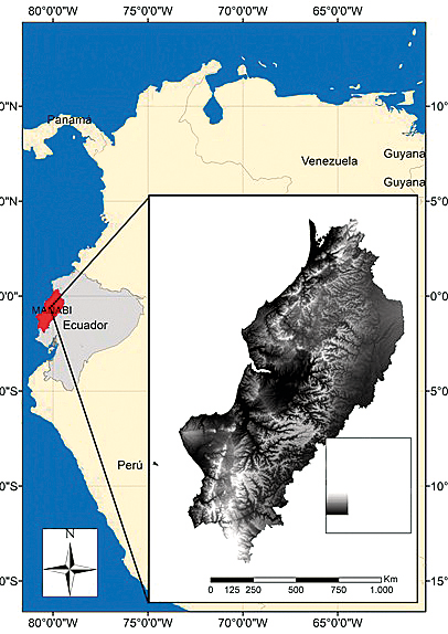
Figure 1 The study area is located in the central western part of Ecuador. Being a coastal region, it receives an enormous influence from the oceanic-atmospheric conditions of the Pacific, on the amounts and precipitation regimes in the continental zone. Source: Authors based on the world maps of the Open Street Map, the shape of Ecuador of the National Institute of Statistics and Censuses (INEC; 2012) and a Digital Model of Elevations to 10 meters of resolution of the Military Geographic Institute of Ecuador (IGM, 2017).
The relief is represented mainly by large coastal plains and river valleys, as well as some mountain systems with maximum elevations of 853 m above sea level. The main river systems are formed by the drainage basins of the Chone and Portoviejo rivers.
The climate presents unimodal rainfall regimes, with a very pronounced concentration and more than nine dry months on the coast with annual totals below 200 mm and a progressive increase in the direction W-E to reach 3000 mm annually in the northeastern sector of the province. The residual soils are mainly composed of very elastic and expansive clays. There are also large areas covered with silt that have a high degree of collapsibility and dispersion materials. These materials are easy to move and as soon as they are excavated, they lose their resistance properties and become easily eroded by the action of runoff (Aguirre and Chávez, 2009).
The use and coverage of the space are mainly agricultural and pasture, making it the first province in Ecuador in terms of total agricultural land (1,643,428 ha) (National Statistics and Census Institute [INEC], 2010), covering 21.16% of the country, with productive activities in the economic sector that represent 14% of the provincial gross value added (Central Bank of Ecuador [ECB], 2014) and 37.1% of the economically active population (INEC, 2010). This productivity is mainly based on family farming, occupying an average area of 4 ha per farmer (Monteros and Salvador, 2015).
MATERIALS AND METHODS
Analysis of satellite information
This study used remote images generated from thermal sensors installed in meteorological satellites of the NOAA (National Oceanic Atmospheric Administration), NCEP (National Center for Environmental Prediction) and EMCGLOBAL (Environmental Modeling Center), responsible for the operations and maintenance of more than 20 numerical prediction systems. The sea surface temperature (SST) images were obtained by the map generator at the International Center for Research on the El Niño Phenomenon (CIIFEN), which was designated at the request of the Western South American Meteorological Services as the Regional Climate Center (CRC) of the World Meteorological Organization (WMO). With this designation, the institution expanded its scope of action towards the provision of climate data and information for the region (CIIFEN, 2017).
The procedure to generate TSS images, described by Cañon (sf), consists of downloading the data captured by the AVHRR sensor, on board the NOAA satellite platform, on the ocean surface. The information is then decoded in any digital image processing software (ERDAS Image type) with HRPT (High Resolution Picture Transmission) processing module. The criteria considered for information processing, in addition to the spatial coverage selected, are cloud cover and geometric correction. For the correction of atmospheric effects, the Split Night Multi - Channel Sea Surface Temperature (SST) algorithm is used, thus allowing the conversion of the information received (digital values read by the satellite) to sea surface temperature, from the radiantics received in channels 4 (10.50 ¿ím-11.30 /<m) and 5 (11.50 /<m -12.50 /<m), where the radiation emitted by the surface is captured in the thermal infrared. Subsequently, the information (already in SST format) is georeferenced and the cloudiness (higher and thicker layers) is filtered (eliminated) fully automatically by the algorithms incorporated in the treatment software.
The VISUAL FOX PRO software perforáis temperature averages every 0.25° both latitude and longitude, with a second programming process. In this same package, the information corresponding to the daily files (images) is averaged to obtain the daily, weekly, fortnightly or monthly average of the parameter under evaluation. Finally, this georeferenced and averaged information is introduced in a third type of software (SURFFER) with which the SST contour maps are obtained. Regarding this procedure, Sobrino et al. (1996), state that this resource is very useful, because it allows to identify thermal anomalies, comparing the value determined for a weekly time lapse with the historical average in a reference period.
Rainfall data processing
Precipitation records stored in the databases of the National Institute of Meteorology and Hydrology [INAMHI] (2017) corresponding to 10 pluviometric stations installed in the coastal region of Ecuador were compiled and systematized, specifically for those sectors where there were greater affectations by extraordinary rainfall or near them. The behavior of the historical average monthly precipitation for the 1998-2016 period was analyzed, as well as the historical annual average for the 1984-2016 period.
Water quality analysis
To assess the effects of rainfall on multipurpose systems, daily water quality data for the last five years were analyzed. This information was obtained in the laboratory of the "Cuatro Esquinas" Water Treatment Plant, belonging to the Poza Honda Multipurpose System, which supplies the population of Portoviejo, capital of the Manabí province, as well as other nearby localities. The analysis of water quality parameters was of great importance in this study, since during the period studied, this service was systematically suspended in some localities, due to the high concentration of sediments in the water, which did not allow its processing, prior to its distribution through the aqueduct system.
Field information gathering
The information related to the effects of the extraordinary rainfall was collected through in situ observations during 5 field visits, in the sectors of Manta, Portoviejo, Lodana, Calceta and Chone, these being the urban and rural population centers with reports of greater damage, attributed to the event of extraordinary rainfall in February - March 2017. In addition, in order to have a broader spectrum of information and to perform in-depth analyses of other effects of the rains, an information-gathering strategy was established based on 20 unstructured interviews with key informants, through selective sampling, selecting participants according to the context, under the focus of qualitative research. The participants were asked with open, flexible questions, without pre-established categories, aiming at greater adaptation to the purposes of the research and to the characteristics of the subjects, in such a way that, as Vargas-Jiménez (2012) indicates, they would allow the participants the possibility of expressing their experiences.
The informants were selected through a non-probability sampling of the inhabitants of the province and representatives of government agencies. A total of 20 informants were selected from the most affected localities, four for each one of the following localities: Manta, Portoviejo, Lodana, Calceta and Chone. Each group consisted of a representative of a government agency and three permanent resident members of each locality affected by the flood event at the time of analysis. All the information obtained was processed and organized, and it allowed us to reach conclusions and to propose alternatives through which to successfully deal with the consequences of future extraordinary rainfall events.
Influence of SST on extreme precipitations
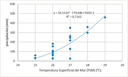
In order to demonstrate the influence of SST on extreme precipitation, the amounts of these variables for January, February and March were correlated with extreme events reported in the last two decades. The SST of the equatorial pacific in the Ecuadorian coast was considered from the images of monthly averages, obtained from the CIIFEEN map generator and the amounts of precipitation of the Portoviejo station, of INAMHI. The correlation was generated with a polynomial function, indicating the trend line and the predictive model.
RESULTS
Anomalies in the sea surface temperature
Comparisons between SST data revealed deviations of greater than 0.5°C from the historical mean, considered thermal anomalies. When these anomalies are positive and persistent in time, in many cases, they cause extraordinary rainfall, as happened in Manabí in the first months of 2017, whose high rainfall records corresponded to coastal areas where thermal anomalies were very evident (Figures 2a, 2b, and 2c).
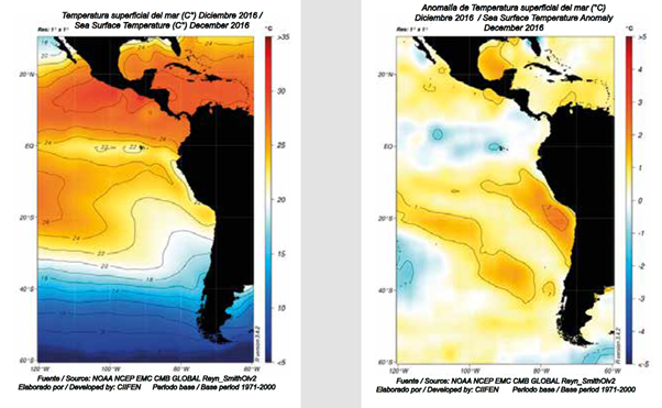
Figure 2a Sea surface temperature and thermal anomalies in equatorial Pacific waters by December 2016. Note the strong anomalies on the coast of Chile and Peru, and moderate anomalies on the coast of Guayaquil and Manabi in Ecuador.
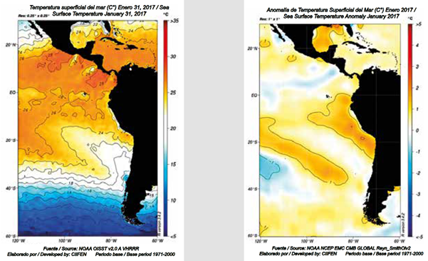
Figure 2b Sea surface temperature and thermal anomalies in equatorial Pacific waters by January 2017. Expansion of the anomaly is observed on the southern coast of Ecuador.
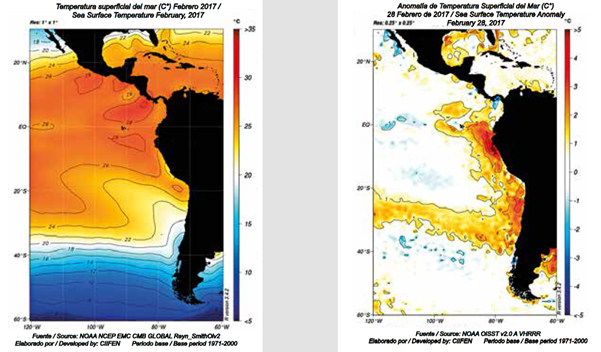
Figure 2c Sea surface temperature and thermal anomalies in equatorial Pacific waters by January 2017. The remarkable increase of the anomaly can be observed in the north coast of Peru and southern Ecuador.
In general, in the eastern region of the Equatorial Pacific Ocean, warm conditions persisted, manifesting themselves through positive anomalies of between 1 and 3 °C, in areas adjacent to the coasts of Ecuador and Peru. It is important to note that the anomalies reported for the period under consideration remained confined to the coastal region of Peru and Ecuador, giving the name "El Niño Costero" to the phenomenon in Peru. Additionally, the weekly values of the Southern Oscillation Index (IOS) presented values of El Niño conditions from the third week of January.
Intertropical Convergence Zone ITCZ
In mid-2016, the Intertropical Convergence Zone (ITCZ) was located on territories of Central America and, in the last week of December of that same year and early January 2017, the system shifted south, until positioned near the equatorial line (Figure 3). The strong convective activity in the ZCIT propitiated the formation of cloudy systems of great vertical development, causing intense rains on the Ecuadorian coast.
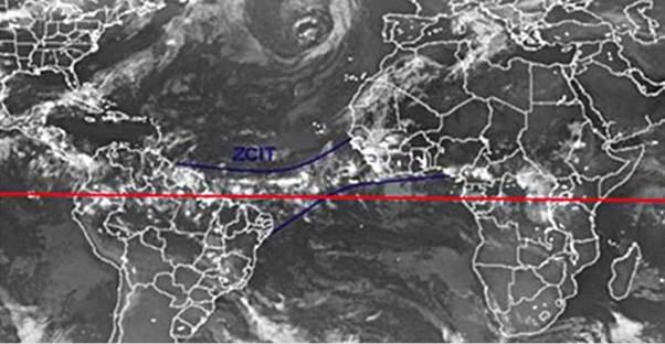
Atmospheric instability in the Amazon
In the satellite image (Figure 3) captured on January 15, 2017 by the Advanced Baseline Imager (ABI) on GOES-16, operated by NOAA and the US National Weather Service, an important cloud belt can be seen along the South American equatorial strip in the Amazon region. This condition also contributed to the precipitation observed in the study area, during which hydrological monitoring indicated that the Chone and Daule rivers were on red alert for overflowing and nine others entered yellow alert status during the first fortnight of February.
Extraordinary rainfall of 2017
The maximum intensity of the extraordinary rainfall of 2017 was recorded in Portoviejo (provincial capital) with 81 mm on February 7 (INAMHI, 2017). The annual rainfall in Portoviejo has historically averaged 602.7 mm, with an annual regime of unimodal type for the entire Ecuadorian coast and 95% of rainfall concentrated between December and May, highlighting its maximums in February and March (Figure 4).
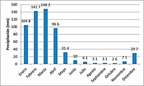
Source: INAMHI (2017). There is a high concentration of rainfall during the first four months of the year and the occurrence of a significant water deficit in the remaining eight months.
Figure 4 Historical average monthly rainfall in Portoviejo station, 1998-2016 period.
This pluviometric regime is conditioned by the presence of the Humboldt current on the South American Pacific coast, which decreases the SST, during the second semester of the year on the Ecuadorian Coast and with it the evaporation of the oceanic waters, evidenced in low amounts of precipitation.
Influence of SST on extreme precipitations
Historical records of precipitation for the Ecuadorian coast (Figure 5) show a striking recurrence of events of extraordinary rains and droughts, distancing significantly from the historical average.
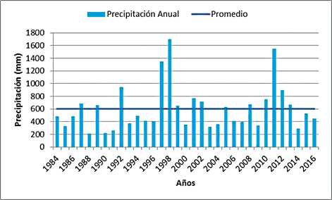
Source: INAMHI (2017). The inter-annual variability records positive and negative anomalies, directly related to the manifestations of the El Niño and La Niña phenomena.
Figure 5 Historical annual average rainfall at Portoviejo station, 1984-2016.
The occurrence of extreme events in the last 20 years on the Ecuadorian coast corresponds to four droughts (1988, 1990, 1991 and 2003) and four extraordinary rainfall events (1997, 1998, 2011 and 2017). These extreme events are strongly influenced by variations in SST, reflected as thermal anomalies. The supposition is confirmed that the positive thermal anomalies in the equatorial Pacific positively affect the occurrence of extraordinary rainfall, as shown in Figure 6, where the correlation between SST and extreme precipitation events, reflects a directly proportional behavior, able to explain 72% of the extraordinary rainfall by SST anomalies. The remaining 28 % of extreme events could be influenced by Intertropical Convergence and atmospheric instability in the Amazon.
DISCUSSION
Causes of the extraordinary precipitations of 2017 and their implications
The extraordinary magnitudes of early 2017 rainfall records on the Ecuadorian coast were due to the combined effect of positive thermal anomalies in the equatorial Pacific, the activity of the ZCIT and atmospheric instability in the Amazon.
Thermal anomalies in the equatorial Pacific
The positive thermal anomalies evidenced from the satellite images are closely related to the extraordinary rainfall that occurred in the South American Pacific coast during the first months of 2017, which had disastrous effects in several urban and rural sectors of the province.
The atypical increase or decrease of SST in the central equatorial Pacific is largely responsible for the variability of the world's climate (Constantino et al., 2011). According to CIIFEN (2017), during the first quarter of 2017, the equatorial coastal Pacific was characterized by a progressive increase in SST that, in mid-February, reached values of up to 3°C above normal, off the coasts of northern Chile, Peru and Ecuador. The forecasts of the global SST models for the February-April and March-May 2017 periods, generated values close to Normal in the central equatorial Pacific sector; while, in a wide sector of the eastern Pacific and next to the coast of South America, particularly in the coast of Ecuador, they presented values above Normal, persisting for more than four weeks.
The Intertropical Convergence Zone
The ZCIT is a band of low atmospheric pressures with frequent formation of clouds of great vertical development, which cause important precipitations to global scale (Venezuelan Air Force [FAV], 2000) in one region. In this regard, Tiscama (2017) maintains that the circulation of the wind in the low levels of the atmosphere allowed important detachments of humidity coming from the ZCIT towards the northern part of Ecuador, causing considerable precipitation events, especially in the northern and inland part of the Ecuadorian coast. During the month of January 2017, according to the records of the Instituto Oceanográfico de la Armada [INOCAR] (2017), the long wave radiation in the central Pacific reflected a clear predominance of average air temperature values, higher than normal throughout the country, the most important being those recorded in the coastal region.
Amazon atmospheric instability
The influence of Amazonian instabilities with dispersed convective nuclei was blocked by the high subtropical pressure system of the Caribbean. Thus, the precipitations observed to date exceeded the normal monthly ones in the provinces of Esmeraldas, Santo Domingo de los Tsáchilas, north of Manabí and Las Galápagos. In the rest of the coastal region, the values were around or below Normal, as in the case of the peninsula of Santa Elena (INAMHI, 2017).
Historical rainfall behavior and extraordinary events in the study area
Extraordinary rainfall events, basically related to El Niño, occur with certain frequency and are often felt in the same region (Corporación Venezolana de Guayana [CVG], 2000), for example on the Ecuadorian coast. However, these hydrometeorological conditions also occur at different times, with significant economic and material costs and considerable numbers of victims.
Extraordinary events may increase in frequency according to future scenarios modeled by Contreras et al. (2014), Thieelen et al. (2015) and CIIFEN (2017), who state that changes will be gradual and accompanied by an increase in climatic variability and extreme events, which will generate more frequent episodes of droughts and floods, as well as an increase in rainfall intensity. Evidence indicates that such events have already occurred, but they also exist today and probably will in the future, so that catastrophes resulting from them are announced and it is imperative to implement adaptation and mitigation measures.
Extraordinary event of 2017
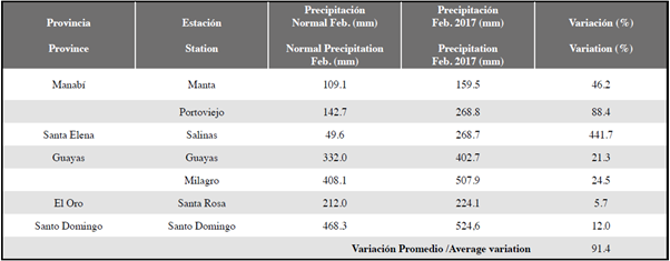
Climate phenomena are complex, multifactorial, dynamic and sometimes difficult to predict. The extraordinary event of February 2017 in the Ecuadorian coastal region is convincing evidence of this, as in mid-January forecasts suggested water deficits with the possible presence of the La Niña phenomenon, due to persistent negative thermal anomalies registered in the SST of the equatorial Pacific (NOAA, 2017). However, the situation was totally different than expected, as high volumes of rainfall occurred as a result of atypical heating of the equatorial Pacific in early February, when the temperature reached about 2°C above its usual values, with the presence of hot and humid air masses from the Pacific. Such oceanic-atmospheric conditions drastically affected the Ecuadorian coastal region, with pluviometric records that exceeded by far the historical averages in the capital of Manabí (Portoviejo) and other localities of neighboring provinces, reported in this study as the anomaly of the SST affected the entire Ecuadorian coastal region (Table 1).
Table 1 Precipitation record for February 2017 at stations on the Ecuadorian coast, compared to the historical average 1984-2016 (Inamhi, 2017). There was a maximum increase of 441% and an overall average of 91%. Records are presented to the south and north of the province of Manabí, showing that the event affected the entire coastal region of Ecuador.
In sum, the positive anomalies in the SST and the atmosphere were combined, creating conditions for the saturation of humidity and the formation of clouds of great vertical development with electrical activity, which generated extraordinary rainfall concentrated in short periods of time, such as those observed on 7, 8 and 17 February 2017, with maximum intensities of 60 mm/h, according to data from INAMHI (2017) in the Portoviejo-UTM station.
The high rainfall was so unusual that intense rains occurred in arid zones, activating channels that had remained inactive for over 20 years, according to the collective memory of the residents. Thus, several localities in the province of Manabí suffered floods and landslides due to soil saturation, overflow of rivers and streams, sewerage collapse, dusting of canals, among other causes. There is no precise explanation for the unusual increase in SST, however, a climatic extreme can be assumed according to the postulates of the Intergovernmental Panel on Climate Change [IPCC] (2007) and, in agreement with Hernández et al. (2013), who affirm that events such as droughts and extreme floods will intensify and increase in frequency.
Field information by key informants
Information provided by key informants on the extraordinary rainfall of 2017 in Manabí is summarized in Table 2, where two main events are evidenced as triggers of the affectations: the overflowing of rivers, streams and estuaries; and land landslides, which have a very high rate of recurrence. As causes of the event, the interviewees mentioned sedimentation and dusting of the channels and riverbeds, and in the case of the Chone canton, they pointed out problems related to "badly done" work on the riverbed. The main effects were on homes with damage to household goods and appliances, educational centers and flooded roads, as well as lost rice, corn, banana and cocoa crops.
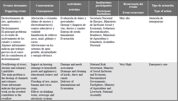
Faced with the situation, key informants reported actions mainly focused on emergency attention, which highlights damage and needs assessment; drainage and cleaning of roads, ducts and canals; delivery of humanitarian aid; and evacuation of housing. With respect to institutional presence, they mentioned the National Risk Secretariat, the Ministry of Social Inclusion and Economy, decentralized governments, the Fire Department, the Ministry of Agriculture and Livestock, and the National Assembly. There is an obvious lack of coordinated risk management processes, and despite this being a frequently recurrent event, according to the perception of key informants, actions focus on emergency attention in post-event operational responses.
In the opinion of the authors of this study, an integrated watershed management process is required, involving the inhabitants of the upper and middle parts. This should include the implementation of sustainable agricultural practices that prioritize soil and forest protection, which would reduce the impact of erosive processes and the magnitude of sedimentation and dusting of rivers and canals.
Disruptions in drinking water service
Erosion and the consequent deterioration of river basins manifest themselves as limiting factors in any hydraulic plan, particularly for three reasons: (a) accelerated sediment production that shortens the useful life of reservoirs and reduces their regulatory capacity, while compromising water demands; (b) base flows and therefore average availability tend to decrease and increase floods, affecting the regularity of the hydrological cycle and, therefore, the operational rules for reservoirs; and, finally, (c) sediments are the most important natural factor in the pollution of surface waters, which deteriorate the water quality. In short, productive activities, especially when not carried out properly, produce significantly harmful effects on water quality (Ruiz et al. 2017), all of which, according to Valencia et al. (2014), have serious implications for human communities.
The intensity of the rains during the first days of February 2017, reached maximum magnitudes of 40 mm in 30 minutes (I30) (INAMHI, 2017). The high volume of water was captured by an open channel, designed as part of an irrigation system, with a distance of more than 30 km from the catchment site to the treatment plant. Sediments from the deforested slopes became incorporated as did agrochemical residues, organic plant material, and wastewater from pig and poultry farms, among other effluents. Likewise, the lithology of the study area, formed mainly by very friable and fragile clay shale, favored the addition of numerous pebbles and fine material to the sources of capture, erosive process and transport aided also by the accelerated deforestation of natural vegetation (forest cover) in the province of Manabí which, in recent years, has reached a rate higher than 5000 ha / year (MAE, 2014). This has left a good part of the soil unprotected, helping to increase the volume of sediments added to the water bodies.
In relation to the above, Regües et al. (2017) state that land use is closely related to the variability of infiltration, since soils unprotected by plant cover lead to greater erosion processes. Similarly, Pérez-Viloria and Gónima (2014) point out that the variation of climatic regimes at the local level in the tropics is caused, among other actions, by intense land interventions associated with anthropogenic activities
Ironically, during the rainy season, the drinking water service suffered persistent interruptions in several sectors of Portoviejo. According to information provided by spokespersons of the municipal company, in charge of the city's drinking water, the temporary suspension of the purification treatment and pumping of water in the Cuatro Esquinas plant created a deficit in the availability of drinking water, as its turbidity increased significantly during the intense rainy season, reaching levels that made its treatment impossible, even with the recent installation and testing of a pre-sedimentator.
Under current conditions, the Cuatro Esquinas plant can only treat water with a maximum of 1800 Nephelometric Turbidity Units (NTU). However, there is a new pre-sedimentator that is in its final stage of installation, to begin with a period of tests and to finally be put into operation in order to increase the water treatment capacity to up to 10000 NTU. However, during the rains of 2017, the turbidity exceeded that figure and reached maximum values of 25000 NTU, so the suspension of the water service was one of the marked effects and will undoubtedly continue to be so in future events of similar magnitude.
The correlation between turbidity and precipitation presented in Figure 7 is the strongest evidence of the above statements. During the first days of February, a positive correlation was observed, with a trend adjusted to a 4th order polynomial and a R2 = 0.96.
Figure 7 shows how turbidity values are kept more or less low and stable with rainfall less than 40 mm in 24 hours, while rainfall with higher intensities exponentially increases turbidity records, exceeding 10,000 NTU with 70 mm of precipitation in 24 hours. Understanding this behavior is fundamental in planning the supply of drinking water in Portoviejo, because the prompt completion and commissioning of the new pre-sedimentator at the Cuatro Esquinas plant will increase the treatment capacity to a maximum of 10000 NTU (PORTOAGUAS, 2017). Thus, in rainfall with intensities greater than 70 mm in 24 h, the plant will have to suspend water treatment, resulting in an inevitable deficit in the city' s water distribution and supply.
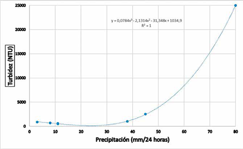
Source: Inamhi (2017) and Portoaguas (2017).
Figure 7 Correlation between the intensity of the rain in 24 hours and the turbidity of the river water. There is an exponential increase in the turbidity of the river water with rainfall of more than 50 mm in 24 hours. Data for the first nine days of February 2017.
Floods in urban and rural sectors
Several sectors of Manabí continued to be flooded for several days, due to the rain storm that was recorded as being stronger on February 7 and 8, 2017, when the water from the heavy rains collapsed the sewage system and irrigation channels, which had been affected by the earthquake of April 16, 2016 (MAGAP, 2016; Senplades, 2016). Among the affected rural communities in the Tosagua canton are Los Corrales, Las Guaijas, Los Pachones, La Poza and La Madera, which are mainly dedicated to short-cycle crops, including rice. In the urban area, the following sites were flooded: Divino Niño, San Pedro, San Roque Bajo, Humberto González, Malecón 1 and 4 and Las Balsas, among other citadels.
As a result of the rains, the Risk Management Secretariat (2017) quantified some 627 families affected by the storm, 400 of which had to be evacuated. One interviewee pointed out that due to the intense rains, the estuaries of El Muerto, Mojinal, Montañita, Las Botijas and Achiote grew, which together formed a "great delta (mouth of a great river)" that even dammed the Carrizal River. The same interviewee maintained that many were affected by these floods and, textually expressed "...if this heavy rain continues as predicted, we are going to continue to be affected..."
The extraordinary precipitations generated floods and sedimentation in rural and urban areas, where in many cases, the need to carry out preventive activities had already been pointed out, and ignored, leading to loss of human lives, goods and services, as well as environmental assets. Official figures from the National Secretariat of Risks indicate about 150000 affected, 8000 ha of damaged crops and more than 1000 km of affected roads. These are just some of the alarming figures that show the need for further research related to this issue, as well as its socialization with communities and government authorities, in order to undertake preventive, mitigating and remedial activities against the impacts of a natural phenomenon that will undoubtedly continue to occur and even more intensely.
Subsurface erosion and sinkholes
One of the little visible effects of the extraordinary rainfall, particularly in the city of Portoviejo, is the erosion caused by subsurface runoff under the road network.
Some of the city's rainwater collectors were affected by the earthquake of April 16, 2016 (Pacheco, 2017), causing progressive infiltrations that, in some cases, resulted in the re-emergence of water through sewage systems and other road infrastructure. The abrupt increase in the flows generated by the extraordinary rainfall heightened the effects of the earthquake and the erosive power of the water caused greater ruptures in the concrete collectors, which gradually created tunnel-like voids under the roads. These processes of subsurface erosion are known as sofussion.
Some of these voids eventually collapsed, creating holes known in popular jargon as socavones (sinkholes), with maximum dimensions of 5 m long by 3 m wide, some of them, with extended damage along the pipe of up to 80 m, detected by robotic cameras that penetrate the ducts and emit images of the state of the pipes.
The eight sinkholes caused strong congestion in the automotive traffic, due to the forced closure of roads with repair costs that, according to technical information from the management of Portoaguas, the company in charge of operation and maintenance of the water system, exceed 110000 dollars. The erosive processes and their consequent collapses continued occurring and, by December 2017, there were already 15 sinkholes in the center of the capital Manabita.
Implications for health
According to information provided by the health personnel at the Verdi Cevallos Balda hospital, in Portoviejo, with the arrival of the rainy season, three types of conditions become recurrent, typified as respiratory infections, gastrointestinal infections and viruses transmitted by biological vectors (mainly mosquitoes), the most frequent being dengue, Zika and chikungunya. Records of patient care for this type of disease in Verdi Cevallos show significant increases with the arrival of rains (determining ecological conditions suitable for the proliferation of transmitting vectors), going from 1949 patients in December 2016 to 2334 in January 2017, representing an increase of 20%.
CONCLUSIONS AND RECOMMENDATIONS
Extraordinary rainfall is a phenomenon of complex and multifactorial origin, which is periodically manifested in certain sectors of Ecuadorian geography, especially on the Pacific coast.
For the intense rains in early 2017 on the Ecuadorian coast, several factors were combined, including the anomalous increase in the SST of the equatorial Pacific, the southward displacement of the ZCIT and atmospheric instabilities in the Amazon region.
Positive thermal anomalies in the equatorial Pacific positively affect the occurrence of extraordinary rainfall.
The consequences were felt in the urban and rural sectors with figures indicating about 150000 affected inhabitants, 8000 ha of lost crops and more than 1000 km of damaged roads.
As a first preventive action, consideration should be given to the possibility of issuing forecasts and early warnings, making effective use of satellite-supported technologies to record atmospheric and oceanographic conditions.
In order to complement the satellite records, the network of terrestrial meteorological stations should be upgraded and extended to allow better control, monitoring and follow-up of rainfall on the territory, at local and regional scales.
Training for agricultural producers is recommended in order to incorporate more environmentally friendly production technologies and to encourage the reduction of greenhouse gas emissions, for example by reducing the use of agrochemicals.
It is beneficial to consider public policies such as the payment of ecosystem services, with a view to implementing actions to protect and conserve forests, soils, and water.
REFERENCES
Aguirre, M., y M. Chávez. 2009. Susceptibilidad al deslizamiento de los suelos y rocas, provincia de Manabí, Ecuador. Tesis de Grado Facultad de Ingeniería en Ciencias de la Tierra, Escuela Superior Politécnica Litoral. [ Links ]
Banco Central del Ecuador. Estadísticas económicas. Quito, Ecuador: Banco Central del Ecuador; 2014. Available: http://anda.inec.gob.ec/anda/index.php/catalog/27018/02/2016. [ Links ]
Cañon, M. (s.f.) Análisis de la temperatura superficial del Mar (TSM) a partir de imágenes NOAA/AVHRR para el Caribe colombiano entre los 70° 30' -78°30' W y 14°30' y 7°30' N. Centro de Investigaciones Oceanográficas e Hidrográficas. CIOH - Escuela Naval - Cartagena. [ Links ]
CIIFEN (Centro Internacional de Investigaciones del Fenómeno El Niño). 2017. Pronóstico_Estacional_Oeste_y_Sur_de_Sudamerica_OND_2017. http://crc-osa.ciifen.org/index.php?option=com_content&view=article&id=247&Itemid=67110/2017. [ Links ]
Constantino, L., M.Z. Gil, A. Jaramillo, P. Benavides y A. Bustillo. 2011. Efecto del cambio y la variabilidad climática en la dinámica de infestación de la broca del café, Hypothenemus hampei en la zona central cafetera de Colombia. Libro de Memorias XXXVIII. Congreso Sociedad Colombiana de Entomología SOCOLEN, Manizales. 106 p. [ Links ]
Contreras, M., J. Cevallos, T. Erazo, M. González y C. Mizobe. 2014. Cambio y variabilidad climática contemporáneos en la costa de Manabí, Ecuador. Rev. La Técnica., 13: 90-99. [ Links ]
CRED. 2004. The OFDA/CRED Internacional Disaster Database Université Catholique de Louvain-Brussels-Belgium ( The OFDA/CRED Internacional Disaster Database Université Catholique de Louvain-Brussels-Belgium (www.em-dat.net : 15/03/2005). [ Links ]
CVG (Corporación Venezolana de Guayana). 2000. Situación meteorológica generadora de las inundaciones y flujos de lodo en el norte-centro de Venezuela, con especial énfasis en la costa norte. Informe preparado por la Empresa de Electrificación del Caroní (EDELCA). 16 p. [ Links ]
FAO (Food and Agriculture Organization). s/f. En tierra segura desastres naturales y tenencia de la tierra. Recuperado de: http://www.fao.org/docrep/013/i1255b/i1255b02.pdf. [ Links ]
FAV (Fuerza Aérea Venezolana). 2000. Análisis de las situaciones meteorológicas que afectaron al área norte costera del país durante el mes de diciembre del año 1999. Informe preparado por el Servicio de Meteorología de la Fuerza Aérea de Venezuela. 10 p. [ Links ]
García, F. e I. Cruz. 2009. Variabilidad de la precipitación pluvial en la región Pacífico Norte de México. Agrociencia, 43:1-9. [ Links ]
Gelcer, E., C. Zotarellic, L. Stevensd, F. Perondia, D. Barretoa, D. Maliaf, H. Ecolef, C. Montonea and J. Southworthg. 2018. Influence of El Niño-Southern oscillation (ENSO) on agroclimatic zoning for tomato in Mozambique. Agr. Forest Met., 248:316-328. [ Links ]
Hernández, M., A. González, M. Ramírez y J. Bracho. 2013. Proyecciones climáticas para el estado de Coahuila usando el modelo precs bajo dos escenarios de emisiones. Agrociencia, 47:523-537. [ Links ]
IGM (Instituto Geográfico Militar) 2017. Modelo Digital de Elevaciones. Instituto Geográfico Militar. Quito, Ecuador. Información Geográfica. 2017. Available: Available: http://www.geoportaligm.gob.ec/portal/index.php/sismo-2016/ 13/07/2019. [ Links ]
Inamhi (Instituto Nacional de Meteorología e Hidrología). 2017. Anuarios Meteorológicos 1991-2012. Instituto Nacional de Meteorología. Quito, Ecuador, 149 p. [ Links ]
INEC (Instituto Nacional de Estadística y Censos). 2010. Censo de población y vivienda [internet]. Quito, Ecuador: Instituto Nacional de Estadísticas y Censos; 2010.Available: Available: http://anda.inec.gob.ec/anda/index.php/catalog/270 16/01/2016. [ Links ]
INEC (Instituto Nacional de Estadística y Censos). 2012. División Político Administrativa del Ecuador. Quito, Ecuador: Instituto Nacional de Estadísticas y Censos ; 2012. Available: Available: http://anda.inec.gob.ec/anda/index.php/catalog/270 16/01/2016. [ Links ]
INOCAR (Instituto Oceanográfico de la Armada). 2017. Eventos en el Ecuador. [online] Inocar.mil.ec. Recuperado de http://www.inocar.mil.ec/web/index.php/que-son-los-tsunamis/73-eventos-en-el-ecuador. [ Links ]
IPCC (Intergovernmental Panel on Climate Change). 2007. Cambio climático: Base de ciencia física. Contribución del Grupo de Trabajo I al cuarto informe de evaluación del IPCC. Cambridge University Press, Cambridge Reino Unido y Nueva York, EEUU. 139 p. [ Links ]
MAE (Ministerio del Ambiente de Ecuador). 2011. Informe de la Segunda Comunicación Nacional sobre Cambio Climático. Programa de las Naciones Unidas para el Desarrollo (PNUD). [ Links ]
MAE (Ministerio del Ambiente de Ecuador). 2014. Mapa histórico de la deforestación del Ecuador continental. Ministerio del Ambiente del Ecuador. Quito, Ecuador, 46 p. [ Links ]
MAGAP (Ministerio de Agricultura, Ganadería Acuacultura y Pesca). 2016. Desastre Natural 2016. Estado situacional. Manabí-Esmeraldas. Informe Técnico. Coordinación General del sistema de Información Nacional. [ Links ]
Monteros, A. y S. Salvador. 2015. Rendimientos de maíz duro seco en el Ecuador, invierno 2015. Quito, Ecuador: Ministerio de Agricultura, Ganadería, Acuacultura y Pesca. [ Links ]
NOAA (Administración Nacional de Aeronáutica y Espacio). 2017. Registros de temperatura Superficial del Mar en aguas del Pacificó Ecuatorial. http://www.cpc.ncep.noaa.gov/products/analysis_monitoring/lanina/enso_evolutionstatus-fcsts-web.pdf]. [ Links ]
OPS (Organización Panamericana de la Salud). 2000. Impacto de los desastres en la salud pública. Editor Erick Noji; Bogotá. 475 p. [ Links ]
Ortiz, C. 2000. Y el Ávila bajó al mar: testimonios y fotografías de la tragedia de Vargas. Caracas: Editorial CEC, S.A., Caracas. 123 p. [ Links ]
Portoaguas. 2017. Informe de Gestión 2017. https://www.epmapap.gob.ec/index.php/transparencia/informe-gestion. [ Links ]
Pacheco, H. 2017. Efectos del sismo del 16 de abril de 2016 en el sector productivo agropecuario de Manabí. Rev. La Técnica, 17: 30-42. [ Links ]
Pérez, C.A. 1983. Precipitaciones extraordinarias en España peninsular. Agric. Soc., 28:189-203. [ Links ]
Pérez-Viloria, M. y L. Gónima. 2014. El contenido del vapor de agua de la atmósfera como indicador del calentamiento global en una zona del Caribe de Colombia. Cuad. Invest. Geogr., 40(2), 477-496. Recuperado de http://aeclim.org/wp-content/uploads/2016/02/0018_PU-SA-IX-2014-L_GONIMA.pdf. [ Links ]
Regües, D., D. Badía, M. Echeverría, M. Gispert, N. Lana-Renault, J. León, E. Nadal-Romero, G. Pardini, and P. Serrano-Muela. 2017. Analyzing the effect of land use and vegetation cover on soil infiltration in three contrasting environments in northeast Spain. Cuad. Invest. Geogr ., 43(1): 141-169. DOI: 10.18172/cig.3164. [ Links ]
Ruiz, D. M., J. P. Martínez I., J. D. Otero S. and A. Figueroa C. 2017. Effects of productive activities on the water quality for human consumption in an Andean basin, a case study. Rev. Internal Cont. Amb., 33(3): 361-375. DOI: 10.20937/RICA.2017-33.03.01. [ Links ]
Secretaría de Gestión de Riesgos. 2017. Informes de situación - época lluviosa 2017. http://www.gestionderiesgos.gob.ec/informes-de-situacion-epoca-lluviosa-2017/. [ Links ]
Senplades (Secretaría Nacional de Planificación y Desarrollo). 2016. Resultados de la evaluación del sismo del 16 de abril. Secretaría Nacional de Planificación y Desarrollo. Recuperado de https://issuu.com/publisenplades/docs/resultados_de_la_evaluaciondelsismo. [ Links ]
Sobrino, J. A., Z.L. Li, M.P. Stoll and F. Becker. 1996. Multi-channel and multi-angle algorithms for estimating sea and land surface temperature with ATSR data. Intern. J. Rem. Sens., 17(11): 2089-2114. DOI:10.1080/01431169608948760. [ Links ]
Thielen, D., J. Cevallos , T. Erazo , I. Zurita, J. Figueroa, J. Quintero, N. Matute, G. Velásquez y M. Puche. 2015. Dinámica de eventos climáticos extremos en la cuenca del río Portoviejo, Manabí. Rev. La Técnica 14: 80-91. [ Links ]
Tiscama, A. 2017. Dos sistemas atmosféricos han influenciado las condiciones atmosféricas del país. Bol. Prensa Inst. Nal Meteor. Hidrol. 13 de enero de 2017. [ Links ]
Valencia, M., A. Figueroa, D. Ruiz, J. Otero, J. Martínez, V. Ceballos y D. González. 2014. Metodológica para el análisis de vulnerabilidad en cuencas abastecedoras de agua ante la variabilidad climática. Ingenierías, 13 (25): 29-43. Recuperado de http://revistas.udem.edu.co/index.php/ingenierias/article/view/994/986. [ Links ]
Vargas-Jiménez, I. 2012. La entrevista en la investigación cualitativa: nuevas tendencias y retos. the interview in the qualitative research: trends and challengers. Rev. Electr. Calidad Educ. Sup., 3 (1): 119-139. [ Links ]
Vega, R., V. Flores, G. Fleites y A. Montalvo. 2013. Agresividad de las precipitaciones en la subcuenca del río San Marcos, Puebla. México. Invest. Geogr., Bol. Inst. Geogr., UNAM. 83: 28-40. DOI: 10.14350/rig.33480. [ Links ]
Received: July 25, 2018; Accepted: June 20, 2019
 Este es un artículo publicado en acceso abierto bajo una licencia Creative Commons
