


 text in
  English (pdf)
 Article in xml format
 Article references
 Send this article by e-mail
 Cited by SciELO
  Cited by Google
  Similars in
SciELO
Similars in
SciELO  Similars in Google
 Permalink
INTRODUCTION
Coastal lagoons are bodies of marine water located inside the coast, separated from the sea by the formation of barriers, or within flood plains, with one or more permanent or temporal connections with the sea (Kjerfve and Magill, 1989; Kjervfe, 1994). They act as buffer of both land and sea forces, dampening runoff from the land side and waves from the marine side, being source or sink of primary and secondary production. They are important repositories of coastal biodiversity, nursing a great variety of larvae and juveniles of invertebrates and fishes, many of those having commercial importance (Barnes, 1980; Mitsch and Gosselink, 1993; Gopal et al., 2000). They are frequently impacted by human activities, especially coastal development (de Jonge et al., 2002). Marinas built in inlets or secluded from the open sea by seawalls and jetties become in effect coastal lagoons. As a new ecosystem, they provide the benefits mentioned above, but also cause impacts, especially if their flushing is poor, or if they affect local circulation, or if boating activities and associated runoff cause pollution or arrival of non-native species (Foster et al., 2016). Coastal lagoon circulation is influenced by river discharges and runoff, winds, tides, seiches, and the balance between evaporation and precipitation, and respond differently to those depending on their localization and geomorphology (e.g., Kjerevfe, 1994; Niedda and Greppi, 2007; Montaño-Ley et al. , 2008). Circulation in marinas or mixed systems is also differentially affected by these factors (e.g., Nece and Falconer, 1989; Lonin and Mendoza, 1997; Velásquez-Montoya and Overton, 2017; Loncar et al., 2018).
In the continental Colombian Caribbean there are numerous coastal lagoons, being Ciénaga Grande de Santa Marta the largest and most productive (Hernández and Gocke, 1990; Sánchez y Zea, 2000; Polanía et al., 2001; Gocke et al., 2003). Around the Santa Marta city, the coastal plain still has a few remaining supratidal salt flats with flood lagoons.
To harbor a private marina for touristic development, a shallow (ca. 2 m deep) lagoon was excavated during the early 1980s in the northern sector of El Rodadero, with a channel opening to the sea. The contours of the lagoon and channel were planted with mangroves, creating a semi-enclosed environment, with apparent good conservation status, as if it were a natural lagoon (see also Martínez-Clavijo, 2013). From having a single connection with the sea, we hypothesize that the tide is an important forcing agent of circulation and mixing, but other physical factors such as winds, rainfall and irradiance, operating at seasonal and daily scales, may influence circulation and mixing, ultimately determining primary production (e.g., Elliott et al., 2001; Rodríguez-Chila et al., 2009). The area experiences a dry season, from December to April, and a rainy season, from May to November. During the dry season, lagoon waters are expected to be more saline and warm from lack of rain and evaporation (from sunlight and strong trade winds), but they could be diluted and cooled by off-shore upwelled waters that may enter the lagoon through the channel via tides, and cooled overnight from the air by the slightly lower temperatures of the northern hemisphere winter. During the rainy season, salinities are expected to be lower from local runoff and from exchange through the channel of coastal waters that are generally less saline from nearby riverine discharge. The higher temperatures of the northern hemisphere summer and fall could also be occasionally lower from overcast skies and during and after heavy rainfall. Lagoon waters are also expected to be vertically stratified after heavy rainfall, but otherwise they should be well-mixed from tidal, thermohaline or wind-driven circulation.
Taking advantage of the location within the city limits, its enclosed and thus secure settings, and its relative simplicity and small size, we are using La Escollera as a natural laboratory for academic and research purposes. Since 2015, we have been measuring environmental variables such as temperature, salinity, water level and light penetration (Zea et al., 2017). The purpose of this paper is to describe the behavior of these variables throughout a year to provide a baseline of their seasonal and daily variations and to partially test the hypotheses presented above, as an initial contribution to the understanding of the variables forcing circulation.
STUDY AREA
La Escollera lagoon (11°12'32,83" N, 74°13'31,68" W) is a human-made private marina located in the northern extreme of Ensenada de Gaira, in the touristic sector El Rodadero, Santa Marta city, Colombia, Caribbean Sea (Figure 1) (see Franco, 2005 for a description of Gaira). The lagoon itself (with an island in the center) was dug out in the early 1980s on the coastal plain, in the supratidal salt flat. It communicates with the nearby ocean through a rather straight, walled channel. On the W side of the lagoon, a marina (Marina Mundial, http://marinamundial.com/), and on the island, a popular discotheque (La Escollera, http://www.laescollerarestaurante.inf.travel/), were built.
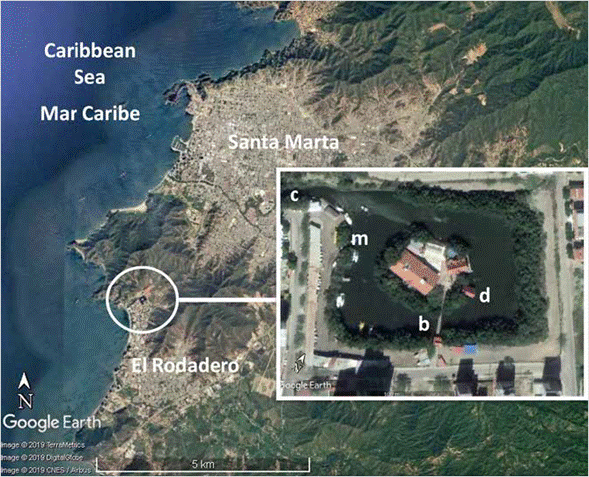
Figure 1 Google Earth images of the study area, showing La Escollera lagoon in the inset. b: bridge, c: channel, d: dock (where data loggers were located), m: marina.
Mangroves, mainly red mangrove Rhizophora mangle, were planted around 1985 on the edges of the lagoon and channel, becoming quite well developed and preserved today as a typical fringe mangrove, with trees up to about 6 m in height (pers. comm. J. Medina), their stilt roots harboring varied fauna and flora (Zea et al., 2017). The only communication with the sea is through the channel (see also Franco, 2005), and there are no permanent streams that open to the lagoon. The whole area is fenced and access to the public restricted, there being an iguana reserve in the southern bank of the channel, for tourists to see from the adjacent walkway (Martínez-Clavijo, 2013). Nowadays city roads surround the entire lagoon, with two drainage openings, respectively on the NE and SW corners, where all the runoff from the neighborhood and adjacent hills enters the lagoon; the only other brackish water input may come indirectly through the channel, driven by tides, when the nearby Gaira river flow is pushed northwards toward the channel mouth by currents and SW storm winds (Franco, 2005). There are no direct sewage discharges into the lagoon and channel (the marina and disco pump their residues into the city sewer system), but there are sewage overspills of the urban sewer through overflow valves and from the streets during the rainy and the touristic high seasons (Franco, 2005; Martínez-Clavijo, 2013).
The lagoon is rectangular, about 167 m x 133 m (including the island and the mangrove fringe), and the channel is about 400 m long and 9-13 m wide. The maximum depth of the lagoon is currently about 2.25 m (normalized to the mean sea level), but about half of the lagoon bottom is shallower than 1.50 m; the depth of the center of the channel ranges between 1.6 and slightly more than 2 m (unpublished bathymetry data). The lagoon bottom is mostly silty, with portions having shell and rubble accumulations; on the SE portion, there are rather thick (about 20 cm), loose beds of the green algae, Caulerpa sertularioides, but these appear to be seasonal.
The Santa Marta area is located in the NW foothills and coastal plains of the Sierra Nevada de Santa Marta massif. It is rather dry, with total precipitation usually around 500 mm (Franco, 2005). The climate alternates between a dry-upwelling season, from December to April, and a rainy season, from May to November. During the upwelling season, NE trade winds blow with high frequency and intensity, sea-water temperatures are rather low (for Southern Caribbean conditions), around 21-26 °C, and salinities high (35-38). During the rainy season the trades slack and SW winds are common during storms, and the seas are warmer (27-28 °C), and less saline (30-35) (Márquez, 1982; Ramírez, 1983, 1990; Salzwedel and Müller, 1983; Blanco, 1988; Franco, 2005).
MATERIALS AND METHODS
Temperature, salinity and sea-water level
Temperature and salinity of the lagoon were measured with a HOBO® U24-002-C conductivity logger (Onset Computer Corporation, Bourne, MA, USA). Sea level was recorded with a HOBO® U20-001-0x-Ti water level logger. Both devices were each placed inside PVC protecting housing, and tied together to a 60 cm-long, 3/4" PVC tube (Figure 2A). For deployment, the tube was inserted through a 3/8" corrugated iron rod (3 m long) which had been anchored vertically into the bottom (driven with the aid of a small sledge hammer), leaving approximately 80 cm free above the bottom. The rod was located in the inner, shaded side of a small boat dock on the SE side of the island (11°12'32,8" N, 74°13'30,2" W). Once inserted, the set was tied to a 5" galvanized stake driven into one of the dock pilings. The set was always positioned approximately at the same depth, by measuring a fixed distance from the top of the dock platform with a sewing tape which had been tied to the housing of the sea level logger. Loggers were retrieved approximately every two weeks (henceforth called a "measurement period"), brought to the laboratory for cleaning, data retrieval and new programming, and then deployed again within a few hours or the next day at most. Measurement interval was 30 minutes.
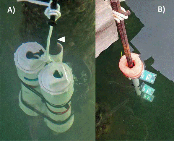
Figure 2 Field setup of data loggers at La Escollera lagoon dock. A) Conductivity/temperature and water level/temperature loggers inside their protective housing. The arrow marks the iron bar anchored into the bottom into which the set is inserted. B) Light/temperature free-floating set with loggers just under the surface (about 0.01 m), and at 0.25 and 0.50 m in depth.
The U24 logger measured conductivity, which was then converted to salinity by the HOBOWARE® Pro software using calibration conductivity and temperature data independently obtained at the beginning and the end of the measurement period. This was done with a pre-calibrated portable YSI® 30 Pro probe (YSI Incorporated, Yellow Springs, OH, USA). The U20 logger measured absolute pressure, which was then converted to water depth by the software using actual calibration measurements of water height above the sensor taken at the beginning of the measurement period with the attached sewing tape. Variations in barometric pressure were not taken into account. For analyses, a 13-month series (January 2017 to February 2018) of salinity and temperature, and a 1-year series of sea-level (January 2017-January 2018) were used to calculate minimum, mean and maximum values. Daily means of temperature and salinity were calculated and plotted with time to determine seasonal patterns. Rain episodes in El Rodadero area were recorded (precipitation not measured) and the dates superimposed to the daily mean series of salinity and temperature to graphically study their relationship. For sea level, absolute values were normalized around the mean level (datum minus mean) but using the mean of each measurement period instead of the overall yearly mean, to account for overlooked small differences between periods in the vertical location of the logger. Temperature, salinity and sea level series are available at https://siam.invemar.org.co/documentos-detalle/336649. For selected comparisons, hourly air temperature and wind velocity data taken at the meteorological station of Punta de Betín in the adjacent Bay of Santa Marta (11°24,5850' N, 74°21,4870' W) were obtained from the Environmental Marine Information System - SIAM of Instituto de Investigaciones Marinas y Costeras - Invemar (http://siam.invemar.org.co), requested through the link http://workflow.invemar.org.co/Forms/accesoadatos. It should be noted that air temperatures from Punta de Betín may be representative for La Escollera, but wind data must be used with caution as Punta de Betín is an open promontory in a peninsula, and the lagoon is protected from two sides by steep hills and also surrounded by mangroves. Rainfall data were discarded as they did not always coincide with the rainfall episodes recorded for El Rodadero.
During retrieval and deployment of loggers, the vertical distribution of salinity and temperature was also measured within the first meter of depth (every 20 cm), with the YSI probe; depth was measured from a metered rope tied to the sensor cable. These data were plotted to compare water column stratification between the dry and rainy seasons, and to infer water mixing after heavy rain episodes. In some cases, the vertical profile of sea-water density was calculated as sigma-t (ot) from salinity (S) and temperature (T), values using the Equation of State for sea water at surface pressure, where ot = p(T; S) - 1000, solved according to the algorithms of Fofonoff and Millard Jr. (1983), through a calculator available on the web (https:// www.mt-oceanography.info/Utilities/density.html).
Light intensity and temperature in the water column
Vertical distribution of temperature and extinction of light in the water column (for a measure of transparency and of light available for primary production) was measured by tying three HOBO® PendantUA-002-08 Temp/Light loggers to a 0.60 m-long, %" PVC pipe, which had a floater ring on one side (Figure 2B). The pipe was then inserted into another 3 m-long iron rod that had been anchored into the soft bottom, but in this case situated in a non-shaded corner of the dock and having a portion above water. Loggers were tied so that one was placed about 0.01 m below the surface (thenceforth to be called "surface"), another at 0.25 cm and the third at 0.50 m in depth. The free flotation allowed for the measurement of light penetration regardless of sea level. Retrieval and deployment was carried out simultaneously with the other loggers. One-year data from March 2017 to March 2018 were analyzed. Temperature data were used to study diurnal vertical variation. For light extinction, only data around noon (10:00-13:30, one case 14:00-15:00) were used, from the first 1-3 days after deployment in which the loggers were still clean of sediments and fouling (73 days total). With these data, the light extinction coefficient k was calculated for each day from the Beer-Lambert equation (I Z = I o e-kZ, Parsons et al., 1984), by regression of light intensity with depth, linearizing the equation to:
lnI Z = -kZ + lnI 0,
Where:
I Z = light intensity at a given depth
k = extinction coefficient (slope of the line)
Z = depth
I 0 = light intensity on the surface (intercept of the line at Z = 0)
Regressions were carried out separately for each day, taking the available (every 30 minutes around noon) vertical measurements as replicates. From the minimum, mean and maximum extinction coefficients and the incident light intensities at the surface, the decrease of light with depth was plotted, and the depth for 1 % light intensity calculated.
RESULTS
Seasonal variation
Time series. La Escollera lagoon waters were on average warm (30.7 °C) and saline (34.3) (Table 1). Sea-water temperatures and salinities followed the local seasonal pattern of dry-upwelling cool and rainy-warm periods (Figure 3). From middle December to early April, the lagoon had temperatures lower than 30 °C, dropping to a minimum of 24.6 °C in middle January, in association with the regional marine upwelling season and the overall slight cooling of the atmosphere during the northern hemisphere winter (down to 23.1 °C). For the rest of the year lagoon and air temperatures remained higher, topping respectively 34.7 °C and 35,0 °C. Salinities were regularly higher (> 35) during the dry season, and intermittently lower during the rainy season, in close association with local runoff from rainfall. Indeed, from middle September to late November salinities dipped below 30 after heavy downpours, reaching 15.1 after about a week of sustained rains in middle November (Figure 3). Wind speeds in the Bay of Santa Marta were high in the dry season, the trade winds blowing with mean and maximum speeds respectively 6.5 m s-1 and 18.6 m s-1, while for the rest of the year mean wind speed was around 3.8 m s-1 and maximum speed did not exceed 15 m s-1 (Figure 3).
Table 1 Overall variation in sea-water temperature, salinity and sea level at La Escollera lagoon, and in air temperature and wind speed at Punta de Betín (Bay of Santa Marta). Data from January 2017 to February 2018. Values calculated directly from all measurements (30 minutes' intervals for sea-water variables and hourly intervals for atmospheric variables).
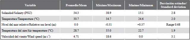
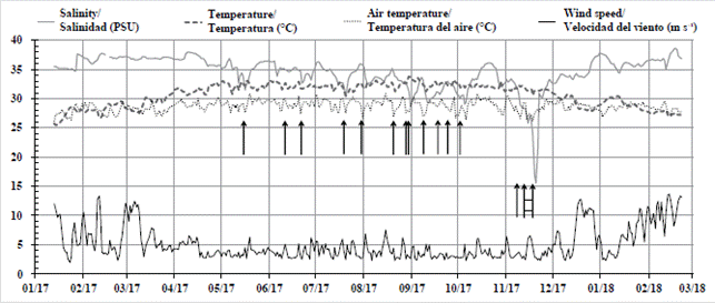
Figure 3 Daily mean values for La Escollera lagoon sea-water salinity and temperature, and for Punta de Betín (Bay of Santa Marta) air temperature and wind speed, from January 2017 to February 2018. Arrows mark recorded occurrence of rainfall (showers and downpours, not measured); rightmost two arrows joined by horizontal lines depict a week of repeated rains (13-18 November).
Vertical profiles. Single-point measurements of salinity and temperature in the vertical profile (0 to 1 m in depth, every 20 cm) taken approximately every two weeks with a handheld sensor, allowed for the comparison of the vertical structure of the water column around noon between the dry and rainy seasons (Figure 4). Overall, during both dry season periods covered by the data (January-April 2017, December 2017-February 2018), the water column was well mixed, while during the rainy season (May-November 2017) the water column was generally mixed but became stratified, with lower salinities at the surface, after rainfall episodes. As an example of the dry season, vertical data around noon from January 13 to April 7 (Figure 4, box A) show that salinity was high (> 35) and the water column well mixed and temperature was cool (< 29 °C), with moments of colder (26 °C) conditions. In contrast, two days after the first heavy rainfall of the 2017 rainy season, which took place on May 16, the water column was still stratified (May 18, box B), with lower salinities on the upper 0.4 m. The water column was well-mixed thereafter (June 6-30, box B), although less saline (< 34-35) and warmer (> 29 °C) than during the dry-season.
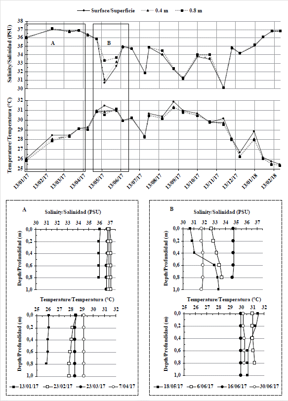
Figure 4 Vertical distribution of salinity and temperature at La Escollera lagoon from January 2017 to February 2018. Data taken approximately every two weeks around noon (10:20-13:00) with a handheld sensor, every 20 cm in depth from the surface to 1 m. Data for the surface, 0.4 m and 0.8 m are presented in the two upper panels. Complete depth profiles for the periods marked in boxes A and B are depicted in the lower panels.
Daily variation
Sea level and tides. The sea level oscillation at La Escollera is clearly dominated by the tide, as it follows the mixed astronomical tide pattern of the Caribbean Sea, with two high and lows per day but of different height, there being periods of spring and neap tides (Figure 5). Within a given lunar cycle, as the days proceed and the tide lags about an hour every day, one of the daily highs becomes smaller, while the other high increases, eventually exchanging places in a complex pattern; at some point one of the two may disappear for a day or two (Figure 5). Relative sea level of one year of measurements, from January 13, 2017 to January 13, 2018, varied between -0.31 m and +0.37 m, the maximal range being 0.68 m (Table 1). For the exemplified 28-day period depicted in Figure 5, relative sea level varied between -0.23 and 0.27, the maximal range being 0.50 m. Sea level change between highs and lows varied between 0.04 m and 0.44 m, with a mean tidal change of 0.19 m. Detailed analysis and decomposition of the tide (astronomical and meteorological components) is being carried out in a separate study.
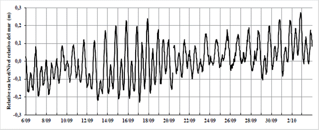
Figure 5 Oscillation of relative sea level at La Escollera lagoon during a 28-day period (September 6 and October 3, 2017). Data normalized for the 28-day series (datum minus series mean); original pressure measurements not corrected for atmospheric pressure.
Seasonal patterns of daily variation.Figures 6 to 8 depict example weekly intervals of daily variation in La Escollera lagoon sea-water salinity, temperature and sea level, and Punta de Betín (Bay of Santa Marta) air temperature and wind speed. The sea-water temperature was measured at the surface, 0.25 m and 0.50 m with the floating loggers. The first interval, April 22-29, 2017 (Figure 6), corresponds to the end of the dry season, when the strong upwelling-inducing trade winds had slacked, salinity remained high but stable, and temperatures were relatively high and followed a daily cycle of day warming and night cooling, warming being slightly greater at the surface of the lagoon than further deeper, the water column cooling uniformly throughout the night. Winds seemed to follow a rather regular pattern of late afternoon intensification. Daily sea level variation, with its 1-hour daily delay in the oscillations, did not seem to relate directly to the variations in sea-water temperature.
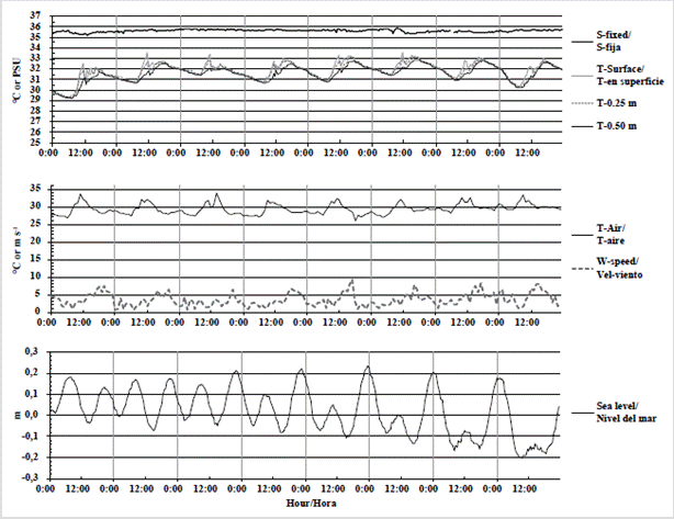
Figure 6 Daily variation of La Escollera lagoon sea-water salinity (S-fixed), temperature (T-at the surface, 0.25 m and 0.5 m in depth) and sea level, and of Punta de Betín (Bay of Santa Marta) air temperature (T-air) and wind speed (W-speed), from April 22 to 29, 2017. Measurement intervals of 30 minutes for sea-water and 1 hour for air. Temperature loggers floated with the tide, thus measuring at the same depths, while the conductivity logger had a fixed position and thus changed depth as the tide changed.
The second interval, September 6-13, 2017 (Figure 7), corresponds to the rainy season, with one episode of heavy rainfall on the afternoon of September 8 (arrow). Overall, salinity remained below 34, becoming progressively lower. Interestingly, there were short pulses of lower salinity, down to 3 units, not directly associated with rainfall, which may reflect circulation of less saline masses that move throughout the lagoon. Sea-water and air temperatures remained high with the regular day warming and night cooling. However, after the rainfall of Sept 8, there was additional cooling, especially overnight at the surface (and in the air), that soon became generalized for the entire water column and made the next two days cooler, possibly owing to an increase in the wind speed and a generalized cloud cover (not measured). Daily sea level variation did not look directly related to either the low salinity pulses or to cooling and warming after the rain episode.
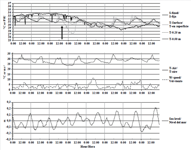
Figure 7 Daily variation of La Escollera lagoon sea-water salinity (S-fixed), temperature (T-at the surface, 0.25 m and 0.5 m in depth) and sea level, and of Punta de Betín (Bay of Santa Marta) air temperature (T-air) and wind speed (W-speed), from September 6 to 13, 2017. Measurement conditions as in Figure 6. The arrow marks the beginning of a heavy rainfall episode (September 8, 16:00).
The third interval, January 13-20, 2018 (Figure 8), corresponds to the dry season, with high salinity (above 34 and higher than 36), and lower sea-water temperatures (mostly below 30 °C even around noon). Air temperatures were generally lower than in April 2017, not warming as much around noon on most days. Winds reached higher speeds than in the other intervals. In contrast, overnight cooling of the lagoon surface occurred every day and was quite important, being 3-6 °C lower in the early morning than around noon. However, there were point episodes of 2-3 °C surface cooling during the afternoon (14:30 to 18:30) almost every day, not associated with air temperature decreases or faster winds, but coincident with the lower half of the ebbing tide, somehow indicative of circulation of cooler water masses.
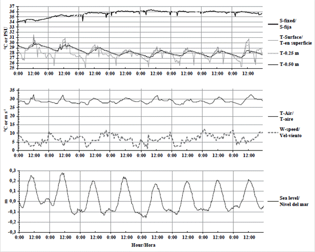
Figure 8 Daily variation of La Escollera lagoon sea-water salinity (S-fixed), temperature (T-at the surface, 0.25 m and 0.5 m in depth) and sea level, and of Punta de Betín (Bay of Santa Marta) air temperature (T-air) and wind speed (W-speed), from January 13-20, 2018. Measurement conditions as in Figure 6.
Mixing after rainfall. After a heavy rainfall and runoff episode on October 2, 2018 (14:30 to 20:30), we were able to follow up the behavior of salinity and temperature in the vertical for the next three days (Figure 9). About 12 hours after the episode (October 3, 07:50), the water column was clearly stratified with lower salinities (18.2) and temperatures (27.8 °C) at the surface (vs. 31.3 for salinity and 30.0 °C for temperature at 1 m in depth, Figure 9B, 9C). About 5 hours later (13:10) surface salinity and temperature had increased respectively to 24.4 and 31.3 °C. The next day (October 4, 14:30) the upper 0.6 m were well mixed and more saline (around 29), remaining as such one day later (October 5, 14:30). In sum, about 42 hours after the rainfall the water column was mixed thoroughly with a salinity similar to that of the adjacent sea (28.3-28.4; temperature was naturally warmer in the lagoon than in the sea, Figure 9B, 9C). Sigma-t calculations for all vertical profiles (Figure 9D) show that while the column was stratified, density was lower at the surface, and therefore mixing probably did not occur through vertical thermohaline exchange. Even though the overnight cooling from October 3 to 4 showed the surface layer to become much colder than deeper layers (Figure 9A), as salinity remained low, it is unlikely that the density of the surface would have been greater than that of deeper layers, to elicit vertical mixing. Instead, a full tidal cycle with a range of 35 cm occurred between measurements on October 3 and 4 (Figure 9A); not discarding wind effects (not considered as there are no local wind measurements), mixing could have been aided by tide-driven circulation.
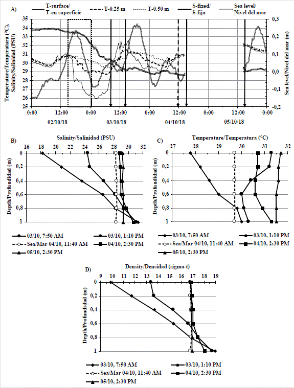
Figure 9 A) Variation of La Escollera lagoon sea-water salinity (S-fixed), temperature (T-at the surface, 0.25 m and 0.5 m in depth) and sea level (October 2 to 5, 2018). Measurement conditions as in Figure 6 (excepting the blank interval, when loggers were retrieved overnight for cleaning). A heavy rainfall episode, which occurred on October 2 from 14:30 to 20:30, is marked by the dashed rectangle. Arrows mark moments of point vertical measurements every 0.2 m for the first 1 m of the water column, carried out with a handheld sensor; dashed arrow is for a measurement done at the adjacent sea. These vertical profiles are represented in B) and C). D) Density values (as sigma-t) calculated from B) and C).
Light extinction
La Escollera lagoon waters are usually greenish, with varied transparency. Only after heavy runoff, when sediments from the surrounding hills washed in, did waters temporarily became brown and murky. The following results on extinction coefficients are only for greenish waters, because the days in which light loggers were clean for valid measurements never coincided with brown murky water. There was not a clear pattern of light extinction either with the seasons or with the sea level (data not shown). Extinction coefficients varied between 0.020 cm-1 and 0.065 cm-1, that is, approximately 2 % to 6.5 % of the light intensity was lost every 1 cm in depth from the value of the previous cm (Table 2, Figure 10). Thus, about 85 % to 100 % of the light was lost within the first meter of water. From calculations for the minimum, mean and maximum extinction coefficients and incident light intensities, surface intensities around noon decreased to 1 % at 0.26 to 3.70 m in depth (mean 1.16 m).
Table 2 Depth at which the light intensity is 1 % of the surface incident light in La Escollera lagoon, calculated from the Beer-Lambert light extinction equation using the minimum, mean and maximum extinction coefficients (k) and incident surface light intensities around noon. Data from 73 days in which the loggers were clean (from March 2017 to March 2018).
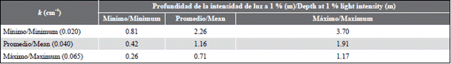
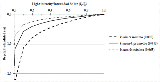
Figure 10 Light extinction in the water column (I Z as a proportion of the surface intensity, I 0 ) as a function of depth. Data and calculations as in Table 2 (units of k are cm ).
DISCUSSION
After more than 30 years of construction, the condition of La Escollera lagoon ecosystem with its well-developed fringe mangrove, is apparently good and healthy. Its trophic status, its main primary producers and drivers, and whether the system is providing the expected nursery and productivity services (e.g., Knoppers, 1994; Duarte and Cebrián, 1996; Nagelkerken et al., 2008; Cloern et al., 2014) is a matter of current and future research. Possible impacts from sewage overflow and from boating activities such as wastewater or non-native species introductions (e.g., Foster et al., 2016) also remain to be determined. So far, during course practices and field observations we have seen diverse but temporarily variable sessile epifauna on the available cryptic hard substratum (mangrove stilt roots, pilings, cement walls, undersides of experimental fouling panels), especially filter feeders, often strongly affected by episodes of heavy runoff and sedimentation. Occasional measurements have shown relatively low pH and oxygen levels, and high inorganic nutrient levels (see Zea et al., 2017).
The lack of a constant riverine runoff makes La Escollera lagoon a negative estuary, which tends to be euryhaline (30-40), sometimes polyhaline (18-30) (Vázquez-Botello et al., 2009), influenced mainly by rain runoff from the local basin. In La Escollera, the seasonal pattern of salinity, similar or higher (> 35, with a maximum of 38.9) than the adjacent sea during the dry season, owing to local evaporation, and intermittently lower (< 30, reaching a minimum of 15.1), from dilution during the rainy season, is similar to studied natural coastal lagoons of the Colombian Caribbean that lack a permanent fresh water inputs. For example, Laguna Sur of Chengue Bay, a much wider natural lagoon located in the adjacent NE of Santa Marta, shows salinities from 37 to 42 during the dry season, and 31-35 during the rainy season but dropping to 23-29 after rainfall (Álvarez-León et al., 1995). In Cocoliso, a karstic island lagoon in Isla Grande, Rosario Islands, near Cartagena city, salinity is similar to the sea, perhaps slightly higher (37), but may drop to 29 during rainstorms (Castillo et al., 1992). In Ciénaga de los Vásquez, an ample lagoon with a rather wide opening to the sea, located south of Bahía de Cartagena, salinity is similar to that of the sea (36) during the dry season, lowering (29-34) during the rainy season (Pérez and Victoria, 1977).
Regarding temperature, the shallowness and enclosure of La Escollera are responsible for relatively strong warming from solar radiation, with temperatures as high as 34.7 °C, while coastal waters of Ensenada de Gaira fluctuate around 27-28 °C (Franco, 2005). The greater warming at the surface in comparison with 0.25 m and 0.50 m in depth during the day, often followed by cooling of surface waters at night, behaves as expected in a body of water which warms from the surface down by incident radiation during the day, and loses heat at night by convection to the air. This lagoon is cooled (dropping to 2526 °C) during the dry season. The same occurs in the nearby Laguna Sur of Chengue Bay, with minimal temperatures of 26 °C during the upwelling season (Álvarez-León et al., 1995). In contrast, in the karstic lagoons of Cocoliso and Ciénaga de los Vásquez near Cartagena, where there is no upwelling, temperatures are regularly high throughout the year (28-32 °C), dropping to 26 °C but after rainstorms (Pérez and Victoria, 1977; Castillo et al., 1992).
This cooling of La Escollera and Laguna Sur probably occurs from nocturnal and wind-driven convective and evaporative heat loss; slightly lower air temperatures (from the northern hemisphere winter) and strong trade winds are present in the area during the dry season. In fact, 3-6 °C nocturnal cooling of the surface layer of La Escollera are the norm during this time, possible increasing surface water density and thus inducing vertical mixing. However, it is clear that upwelled, cool coastal waters (23-26 °C, cf. Franco, 2005) enter the lagoon through tide-driven circulation. The occurrence of spikes of 2-3 °C of surface cooling during the day in the dry season at La Escollera, not associated with lower air temperatures, could occur from rapid sinking of surface waters from evaporative cooling by the wind (Castillo et al., 1992) but also from circulation throughout the lagoon of cooler water masses.
The daytime (around noon) vertical profiles (down to 1 m in depth) of salinity and temperature in La Escollera lagoon show that a well-mixed water column is the norm, excepting after heavy rainfall, when the water column becomes stratified, with surface layers less saline than deeper layers. Vertical profiles also follow the seasonal pattern of cool and salty waters during the dry season, and the warmer and less saline waters during the rainy season. The same seasonal pattern of well-mixed vs. stratified column is seen, but in a larger vertical scale, in the coastal waters of Ensenada de Gaira (Franco, 2005). The occurrence during the dry season of days when the water column was uniformly cool around noon (e.g., 26 °C), indicate that upwelled waters are entering the lagoon, rather than being cooled overnight or by wind. In fact, the documented, rather quick mixing (hours to about 2 days) of the stratified water column formed after heavy rainfall, could not be accounted for by vertical exchange from increased density at the surface from overnight cooling, but rather by tide-driven circulation.
In chocked coastal lagoons like La Escollera, with a single long narrow entrance channel, circulation is assumedly driven more by winds and runoff than by tidal oscillations, because the channel dampens water level fluctuations, significantly reducing tidal oscillation (Kjferve and Maguill, 1989; Kjferve, 1994). However, sea level oscillation inside La Escollera follows the regular astronomical mixed tide for the area, being of about the same magnitude to that at the coast (unpublished work). This shows that somehow the morphology of the channel allows for the tide to ebb and flood apparently without much dissipation, thus forcing circulation. Perhaps by being surrounded by tall mangroves, and not having any streams that open in the lagoon, winds and runoff have a minimal or sporadic influence on circulation, allowing tides to dominate. Considering a lagoon depth of 1.5 m, and the minimal (0.04 m), maximal (0.44 m) and mean (0.19 m) difference between high and low tide during the lunar month depicted in Figure 5, the volume of water entering or leaving the lagoon would vary from 0.04 % to 29.3 % (mean 12.7 %) during each ebbing or flooding. With two ebbs and two floods per day, on average an equivalent of about 51 % of lagoon volume would be exchanged with the sea each day, reaching 80 % during spring tides. A more detailed analysis of the role of tides in circulation, in progress, would be needed to confirm these assertions.
The light regime of La Escollera lagoon waters is such that primary production in most of the water column is possible. Its greenish waters are indicative of relatively high phytoplankton density and thus of photosynthesis. Measured (morning to noon) oxygen levels are low (ca. 1.7-2.83 mgL-1), in comparison to those of the outer canal and the sea (> 5 mgL-1, cf. Zea et al., 2017), and show that processes that lead to its consumption are significant. Oxygen, primary production and respiration measurements are being undertaken and the results will be published elsewhere. Our water transparency measurements neither showed a seasonal trend, nor were they related to the tide, indicating a complex scenario for the control of phytoplankton biomass. The light extinction coefficients show that light is regularly reaching the bottom, as 1 % of incident light intensity around noon could reach more than 1 m in depth, and even almost 2 m in average transparency conditions. Indeed, part of the lagoon bottom supports, apparently seasonally, thick carpets of the green algae Caulerpa sertularioides.
The above observations and data provide the basis for developing research questions regarding the role of 1) physical variables in circulation, flushing and sediment transport (and in maintaining the channel open); 2) circulation and its variability in primary production and respiration, both pelagic and benthic, and 3) of extreme events of high runoff and sedimentation and oxygen depletion in epifaunal community succession.

