


 text in
  English (pdf)
 Article in xml format
 Article references
 Send this article by e-mail
 Cited by SciELO
  Cited by Google
  Similars in
SciELO
Similars in
SciELO  Similars in Google
 Permalink
INTRODUCTION
The Millennium Ecosystem Assessment provides a holistic view of the value of the biosphere, taking into account ecological, socioeconomic, and cultural aspects of Ecosystem Services (ES) that are of global, regional and local importance (Agardy et al., 2005). The concept of ES has gained increasing attention amongst scientists, environmentalists and policy makers in recent years. Its basic idea is to provide a tool to integrate social, economic and environmental components of services provided by ecosystems in order to guide strategic decision making. It is an effective way to demonstrate the benefits that ecosystems provide to humans and their values (monetary and non-monetary) (De Groot, 2010; Costanza et al., 2014).
Liquete et al. (2013) carried out a literature review focused on Marine and Coastal ES, where they found that the most common ES studied were food provision, water purification, coastal protection, and recreation and tourism. They identified knowledge gaps regarding the availability of indicators that measure the capacity, flow or benefit derived from each ES.
Identifying and valuing ES has significantly contributed to our understanding of the reasons why we must conserve biodiversity, and why the use of marine resources must be carried out sustainably. Habitat change, climate change, over-exploitation and pollution are becoming more acute and frequent in marine and coastal environments, such as in the Tropical Eastern Pacific (Backer et al., 2010). The study of ES allows us to: define management choices more accurately; confront environmental, political, social and administrative shortcomings; guide decision makers and communities towards sustainability and, hopefully, conservation (Cork, 2010). The Millennium Ecosystem Assessment highlighted the importance of ecosystems to humans, and furthermore presented the current state of ES worldwide. The importance of the Ecosystem Assessment has increased with the development of the Sustainable Development Goals (SDGs), which were created in 2015 to address several issues for human welfare and the environment. Different works have identified important contributions of this approach in the development of plans to achieve the goals set out in about 12 of the 17 SDGs (McCartney et al., 2015; Wood et al., 2018; Veidemane, 2019). This research represents a contribution towards SDG 13th Climate Action and 14th Life below Water. According to this assessment, over 60 % of ES worldwide are degraded (Agardy et al., 2005). Therefore, it is mandatory to call attention to the state of ES and research associated with the conservation of ecosystems and their services.
Cantera et al. (2013) presented a description of the ecological, environmental and socioeconomic conditions of Uramba MPA, as well as the challenges for the conservation of ecosystem services in the region, a task in which all stakeholders should be integrated. This social-ecological context adds to the different systematic attempts to establish an interdisciplinary methodological framework for vulnerability, which we define in this paper as the degree to which a system or some component is likely to experience harm due to exposure to a perturbation or stressor (Turner II et al., 2003; Mumby et al., 2014; Weißhuhn et al., 2018). Vulnerability assessment focused on stressors has proven to be insufficient for understanding the responses of an affected system. A more complex understanding should include risk and resilience. Risk is a measure of the likelihood of the occurrence of an event, and the magnitude of its consequences. Despite the different meanings of ecological resilience, here we take the definition by Walker et al. (in Spears et al., 2015), that is “the capacity of a system to absorb disturbance and reorganize while undergoing change so as to retain essentially the same function, structure, identity and feedbacks”; it means the capacity of a system to maintain or recover certain functions despite disturbance (Turner II et al., 2003).
Ecosystem vulnerability assessments have been identified as a valid approach to address the management of threats (Oppenheimer et al., 2014; Weißhuhn et al., 2018). Coupling the study of habitat vulnerability with the identification of ecosystem services can be useful to determine which actions must be taken to prevent stressful events from happening (prevention), or at least to alleviate their effects (adaptation) (Schröter et al., 2004). Knowledge based on ecological resilience and ecological threshold can be used as practical guidance for policymakers (Spears et al., 2015; Weißhuhn et al., 2018). Ecological resilience is the ability to maintain ecological functions, which differ from one ecosystem to other. Ecological thresholds represent the limits where even changes in environmental conditions associated with natural and/or anthropogenic stressors lead to changes in ecosystem states (Sasaki et al., 2015).
Uramba MPA presents a wide variety of ecosystems, which creates a challenge for decision-making regarding which ecosystems and which services should be prioritized. As suggested by Mumby et al. (2014), vulnerability is a useful concept for areas that represent a complex socio-ecological system, and it is helpful to combine this analysis with ecological resilience (Robertson and McGee, 2003; Hughes et al., 2005; Baho et al., 2017; Carr et al., 2017). This is why establishing ecological resilience can be a tool to mitigate the impact of different stressors or promote actions that reduce vulnerability. For these reasons, our main goal was to assess the vulnerability of ecosystem services in Uramba MPA, as a model in the Tropical Eastern Pacific. The results of this analysis not only provide key information for decision making related to the administration and management of marine protected areas, but it also to long-term sustainability, resilience and adaptation to natural hazards, which are difficult to avoid not only in the area studied, but also in other MPAs with similar characteristics in the Tropical Eastern Pacific.
STUDY AREA
Uramba MPA (3° 56′ to 4° 05′ N and 77º 19′ to 77° 21′ W) belongs to the Tumbes-Chocó-Magdalena biodiversity hotspot, established by Conservation International as one of 36 global priority regions for conservancy (www.conservation.org; Search: 20-July-20). In 2010, the Colombian government established it as a Marine Protected Area (http://www.parquesnacionales.gov.co; Search: 20-July-20) under the figure of protection of National Natural Park, meaning it is an area in which its extension allows ecological autoregulation, the ecosystems are not being altered by human exploitation, and it has a scientific, educative, aesthetic, and recreative value at national level (Decree 2811 of 1974).
The MPA has an extent of approximately 136 km2 of marine and coastal ecosystems. These ecosystems are presented in Figure 1, and they include mangroves, sandy beaches, mud flats, rocky coast and pelagic systems (Cantera et al., 1999). A review by Cantera et al. (2013) indicated the presence of 2178 species in Uramba MPA. Castellanos-Galindo et al. (2011) recorded 39 species (1 sponge, 5 cnidarians, 10 molluscs, 7 crustaceans and 16 fish) in threatened status; some of these species are economically important to human populations (i.e.: conch Anadara tuberculosa and Anadara similis; snail Titanostrombus galeatus; shrimp Penaeus vannamei and Penaeus occidentalis; and grouper Epinephelus itajara).
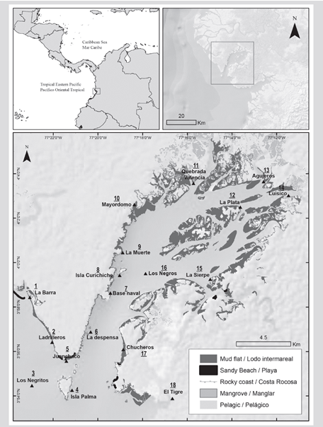
The human settlements of the Uramba MPA are African descendants that have been sustained by the ecosystem services provided by the mangroves, estuaries, and the continental jungle area surrounding the bay. Most of the communities living in the interior are scattered in various areas with low population numbers: La Plata (location 12), Luisico (location 14), Chucheros (location 17) and have ways of life based mainly on fishing (mullets, snappers, catfish, shrimp and bivalves), hunting (sloths, raccoons, and agoutis) and artisanal logging. The communities in the outer zone of Uramba MPA, who inhabit the towns of Juanchaco (location 5), Ladrilleros (location 2), and La Barra (location 1) are also African descendants and derive their livelihood mainly from beach tourism and Humpback whale watching. The population of these settlements is approximately 30 000 people (DANE, 2012). In recent years, both the inhabitants of the exterior and interior have developed ecotourism projects that make non-extractive use of the ecosystem services of all the Uramba MPA ecosystems. There are also some indigenous communities, but they only partially derive their livelihood from the coastal and marine ecosystems, due to the location of their settlements deep in the jungle.
MATERIALS AND METHODS
Identification of stressors
A literature review and an expert workshop were conducted to summarize potential stressors present in Uramba MPA. The literature taken into account were Invemar-Univalle-Inciva (2006), Univalle (2010), and Castellanos-Galindo et al. (2011). The expert’s workshop was conducted in the context of the Integrated Coastal Zone Management Course in 2012, issued by the Colombian Marine and Coastal Research Institute “Jose Benito Vives de Andreis”. The expert workshop team was formed by local experts with a lot of traditional knowledge of Uramba MPA, staff members from Colombian National Natural Parks, staff members of the Valle Regional Autonomous Corporation, researchers from the research group Ecology of Estuaries and Mangroves with 20 years of experience studying Uramba MPA, and professors from the University of Valle with more than 45 years of experience studying Uramba MPA. The expert’s workshop was conducted using participatory tools. The experts participated in a story map section, in which they identified the Uramba MPA stressors in a map. Both the data obtained from the story map and the literature review were validated and spatially characterized in the field through boat trips around the entire Uramba MPA.
Estimation of ecosystem services vulnerability
First, the five coastal types of ecosystems present in Uramba MPA were identified: rocky coast, mangroves, mud flats, sandy beaches and pelagic systems. In each ecosystem, relevant ecosystem services were identified based on knowledge of their representativeness and availability in the area.
The ecosystem services of the Uramba MPA were characterized using as context the extent literature available regarding ecosystem services. The concept was re-established in the late 1970s (Schumacher, 1973), and was put on the agenda of ecosystem research at the end of the last century (Costanza et al., 1997; Daily, 1997; Mooney and Ehrlich, 1997), leading to the boom of ecosystem services research in the 2000s (Agardy et al., 2005; Boyd and Banzhaf, 2007; Costanza et al., 2014, 2017). The systematic review classification for marine and coastal systems developed by Liquete et al. (2013) were taken into account to classify them.
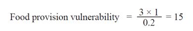
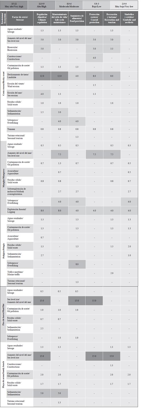
Researchers from the research group Ecology of Estuaries and Mangroves and professors of the Marine Biology section at the University of Valle used the results from the literature review, the talking maps, the boat trips to select and estimate the magnitude of the stressors that could vulnerate the ecosystem services of each coastal ecosystem. Professors and researchers also estimated risk and resilience. The magnitude of the stressors was evaluated using the spatial scale proposed by Halpern et al. (2008), where stressors were rated as high (3) when they affected the Tropical Eastern Pacific region; moderate (2) when they affected the entire MPA; and low (1) when they affected only the location where they were encountered. The probability of occurrence of each stressor and its consequences (risk), and the ability of an ecosystem to recover its services (resilience) were estimated as minimum (0.2), low (0.4), moderate (0.6), high (0.8), and maximum (1). The risk was determined as maximum (1) when the probability of occurrence was very high, and minimum (0.2) when the probability was very low. The resilience was determined as maximum (1) when the ability of the ecosystem to recover was very high, and minimum (0.2) when the probability was very low.
Vulnerability was determinate as a mathematical function of the stressor’s magnitude, multiplied by the risk (probability of occurrence and its consequences), and divided by the resilience (capacity of ecosystem recovery) (Kaly et al., 1999; Gowrie, 2003; Turner II et al., 2003; Zacharias and Gregr, 2005).
For example, for the mudflat ecosystem, we would calculate vulnerability of food provision as follows, with the threat “sea level rise” as a stressor with the maximum value of 3, risk with the maximum value of 1, and resilience with the minimum value of 0.2.
Due to the overlap in the ranges of values obtained, modulated mainly by the magnitude of the stressor, a color model was generated to facilitate its interpretation using green to represent minimum vulnerability and intense red to represent maximum vulnerability.
RESULTS
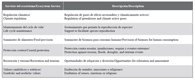
The Uramba MPA natural and anthropogenic stressors identified by the literature review, the story map and the boat field trips around Uramba MPA are presented in blue and red respectively in Figure 2. 17 stressors were identified, from which seven were natural and ten anthropogenic. The most severe and common were bioerosion, water erosion, sewage, marine traffic, solid waste pollution and human constructions. The locations more affected by stressors were Ladrilleros (location 2), Juanchaco (location 5), and Base Naval (location 7), positioned at the outer region of the MPA, while the lesser affected locations were found in the inner region. The ecosystem services selected in Uramba MPA and their descriptions according Liquete et al. (2013) are presented in Table 1. The vulnerability of Uramba MPA ecosystem services values determined by the researchers and professors with a wide knowledge of Uramba MPA are showed in Table 2, they are classifying by ecosystem, ecosystem services and stressors.
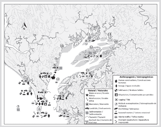
Table 1 Ecosystem services selected and their descriptions according Liquete et al. (2013) classification.
DISCUSSION
Uramba MPA contains all the main coastal and marine ecosystems found along the Colombian Pacific coast with the exception of coral reefs, although there are records of isolated coral colonies (Pocillopora damicornis and P. capitata) in Los Negritos (location 3, Figure 1). Sandy beaches are found along the two outer limits of the Uramba MPA, at north La Barra (location 1, Figure 1), Ladrilleros (location 2, Figure 1), Juanchaco (location 5, Figure 1), and at south Chucheros (location 17, Figure 1), and El Tigre (location 18, Figure 1). These beaches are formed by the accumulation of sand carried by rivers and marine hydrodynamic processes, are enriched by organic matter derived from the decomposition of plant debris from the mangroves and, because of their intensive seasonal use in tourism activities, are contaminated in a significant way by solid waste, mainly plastic (Riascos et al., 2019). The rocky coast, containing cliffs and rocky beaches derived from the erosion of these cliffs, is the most abundant ecosystem. Some of these rocky formations form islands or islets, and even an isolated rocky formation outside the Uramba MPA called Los Negritos (location 3, Figure 1). There are important intertidal offshore rocky reefs in the inner part of La Plata (location 12, Figure 1), which are rocky formations composed of about 10 small rocky islands and islets. These rocky formations are in the active process of erosion due to seasonally strong waves in some regions and facilitated by organisms in an intense process of bioerosion (Cantera et al., 1998; Cobo-Viveros and Cantera, 2015; Cantera, 2016). The bay presents important patches of mangroves in a good state of conservation in the north region and extensive areas in the interior and south border, with about 3000 ha conserved (Rhizophora mangle, R. racemosa, Avicennia germinans, Laguncularia racemosa, Conocarpus erectus, Pelliciera rhizophorae and Mora oleífera). These mangroves are not as complex as the mangroves of the south of Colombia. However, mangroves can reach 35 m in the interior region of Uramba MPA in Quebrada Valencia (location 11, Figure 1), Agujeros (location 13, Figure 1), Luisico (location 14, Figure 1), and La Sierpe (location 15, Figure 1). All the mangroves and their biodiversity (wood, fish, crustaceans, mollusks and wildlife) are subject to artisanal exploitation by the inhabitants of the region. The pelagic habitats are in good condition since the contamination levels are low.
The assessment of Uramba MPA identified numerous natural and anthropogenic potential stressors affecting principally the outer locations Ladrilleros (location 2), Juanchaco (location 5), and Base Naval (location 7). The main natural stressors found at these locations were water erosion, bioerosion and landslides. It is important to clarify that is less that can be done to manage tis stressors, however actions can be conducted to mitigate the risk that they represent to human settlements in Uramba MPA. The synergic effects caused by the combination of water erosion, bioerosion and landslides tend to be more intense in the outer locations as they are more exposed to waves, winds, and storms (Cantera, 1991; Posada et al., 2009). The great number of anthropogenic stressors in these locations could be explained by the human settlements with a population size of approximately 30 000 people, a number that reaches up to 50 000 people in the tourism-related high season (DANE, 2012). Stressors associated with human settlements and their activities are sewage, solid waste, human constructions and oil pollution at these locations. Sewage and waste disposal are not properly managed in the area. Human constructions may enhance natural habitat loss. Oil spills generated accidentally or arbitrarily during boating operations stress the marine and coastal systems of the MPA. On the contrary, the inner region of the Uramba MPA presents fewer stressors. This can probably be accounted for by the low population living there (i.e. La Plata, location 12, with approximately 200 people [DANE, 2012]), and the fact that its ecosystems are less exposed to natural phenomena such as waves, winds, and storms (Cantera, 1991).
Anthropogenic and natural stressors can transform, degrade, or limit the provision of Ecosystem Services. Marine ecosystems services have been researched widely, with research focused on mangroves (Duke et al., 2007; Barbier et al., 2011; Vo et al., 2012; Liquete et al., 2013; Mukherjee et al., 2014; Thompson et al., 2019), corals (Moberg et al., 1999; Laurans et al., 2013; Woodhead et al., 2019) and rocky coasts (Wilson, 2005; Branch et al., 2008; Marcelli et al., 2018). In Colombia, research has been conducted on marine ecosystem services on both Caribbean (Blanco et al., 2012; Aldana-Domínguez et al., 2017) and Pacific coasts of Colombia (Cantera et al., 2013; Palacios and Cantera, 2017; Mejía Rentería et al., 2019; Palacios et al., 2019; Rojas et al., 2019). Cantera et al. (2013) identified mangrove and rocky coast ecosystems as key systems for the human settlements in Uramba MPA. Palacios and Cantera (2017) and Palacios et al. (2019) identified food provision as a key ecosystem service provided by mangroves in the Colombian Pacific and in Uramba MPA. It has been demonstrated that the Bay contributes to climate regulation throughout southwestern Colombia and to the functioning of mangroves, mud flats and rocky reefs as nurseries in which larvae and juvenile forms of many economically and ecologically important species find food and protection (Invemar-Univalle, 2011). The entire bay area is protected as a National Natural Park, which implies that these ecosystem services retain their spatial and temporal integrity (Cantera et al., 2013).
Uramba MPA mud flats and sandy beaches are characterized by a very low slope, indicating their vulnerability in a sea level rise scenario (Olivo et al., 2011). To overcome sea level rise, they must accrete faster than the sea level rises. Otherwise, flooding is inevitable, and it will be followed by increased erosion. The inundation caused by sea level rise and the changes to the accretion-erosion cycle will affect microbial activity (Chambers et al., 2013). It will cause alterations to the rate of carbon sequestration, carbon balance, and phosphorus and nitrogen exportation (Steinmuller and Chambers, 2019). As a result, climate regulation will be affected in Uramba MPA sandy beaches and mud flats. The changes of climate regulation could accelerate mineralization rates or leaching in coastal wetland soils, and it may produce harmful algal blooms and eutrophication (Steinmuller and Chambers, 2019).
Mud flats and sandy beaches are widely known to provide coastal protection. These systems serve as natural buffer zones that protect the coastline and back shore coastal ecosystems from waves, surges, tides, and marine flooding. The vulnerability of sandy beaches and mud flats to sea level rise has been discussed globally by other studies (Simm, 1996; Doody, 2012; Dominati, 2014; IPCC, 2019). Sea level rise reduces their capability to protect the coast against storms, high waves such as tsunamis, and ecosystem erosion (Hanley et al., 2014).
Organisms that live in mud flats have environmental requirements related to relatively low salinity and high temperature. Sea level rise and its associated inundation will raise the salinity, lower the temperature, and change the circulation patterns of these systems. As an answer, the community structure and the food webs will change. Hence, the mud flat ES of food provision could be modified and/or affected.
Sandy beaches are universally recognized for their important recreational value, and producing high economic revenue associated with coastal tourism worldwide (King and Symes, 2004). Beaches are appraised by residents and tourists for their cultural, aesthetic, and recreational value (Defeo et al., 2009). Increased loss of beach area can be associated with sea level rise, with subsequent losses of beach habitat caused by shoreline migration and erosion, and reduced deposition of new sand via littoral transport (King et al., 2018). In Uramba MPA, loss of its recreation and tourism ES will affect economic activities in Ladrilleros (location 2) and Juanchaco (location 5). Their beaches are well recognized as tourist destinations in the Colombian Pacific coast. The local economy depends heavily on tourism. Residents provide accommodation services, food, commercial facilities, and guided tours to nearby natural landscapes (Cantera et al., 2013).
The rocky coast located at the outer region of Uramba MPA is exposed to strong wave action and subjected to heavy erosion. Erosion caused by wave forces is further reinforced by wind forces and bioeroders that graze algae and bore the substrate. Bioerosion and water erosion were the main natural stressors identified in Uramba MPA by the present study. These stressors have been documented as major causes of impact in the area (Cantera, 1991; Cobo-Viveros, 2007; Posada et al., 2009; Cantera et al., 2013). These combined effects of erosion processes accelerate the fall, decomposition, and weathering of cliffs and rocky beaches, causing landslides. In Uramba MPA’s rocky coast, landslides represent the highest risk for the ES of food provision. Landslides harm climate regulation, coastal protection, and recreation and tourism. Uramba MPA’s rocky coast erosion and landslides lead to the loss of their capacity to provide coastal protection. Coastal erosion in combination with human construction threaten the structural integrity of the rocky coast and its ability to provide coastal protection.
Rocky coasts deliver sediments to the littoral and the open sea through erosion. If the amount of the output material increases, the physical and chemical properties of the surrounding systems will be affected (Violante, 2009). Chemical weathering may have an important effect through the movement of major masses, such as in a landslide scenario, and these changes will modify climate regulation in Uramba MPA’s rocky coasts.
Landslides and erosion can change the habitats that serve to maintain life cycles, especially tidal pools. The use of tidal pools during early ontogenetic stages is common, as their conditions allow for enhanced growth and provide refuge from larger predators (Dias et al., 2016). Structural changes or loss of rocky tidal pools may undermine the capacity of Uramba MPA’s rocky coast to maintain life cycles.
Other ecosystems heavily affected by sea level rise are mangroves. Although mangroves are known to be in a system of constant change, the stratification of the different species of mangroves is closely related to tidal changes, with species better adapted to high levels of salinity in the lower part of the tidal line and species with less tolerance in the upper part. Due to the processes of erosion and sedimentation, the ecosystem is in constant migration with changes in the distribution of these species. If the rate of sea level rise exceeds that of mangrove migration, the ecosystem will sink and probably be replaced. In contrast, if the increase in sea level is relatively slow, mangroves can remain on the shoreline by accumulating sediments vertically and growing on them (Yáñez-Arancibia et al., 1998; Coll et al., 2001). If Uramba MPA mangroves cannot deal with the rate of sea level rise, ES such as coastal protection, life cycle maintenance, and recreation and tourism are at stake. The logging and destruction of mangrove areas will lead to the loss of a very important habitat and the base of the food web in the Colombian Pacific Ocean (Univalle, 2010; Invemar-Univalle, 2011).
Uramba MPA mangroves have been studied extensively due to their characteristics as a key habitat for breeding and larval development. Mangroves provide adequate physicochemical conditions, refuge and food sources for early life stages. Furthermore, they are important to the reproduction of ecologically and commercially important species in the Colombian Pacific Ocean (Invemar-Univalle-Inciva, 2006; Cantera et al., 2013). Such characteristics make mangroves important for life cycle maintenance, an ecosystem service that is threatened by logging and sea level rise in Uramba MPA.
Mangroves provide coastal protection by attenuating waves and surge, dissipating wave energy through their root systems and trunks, reducing wind-related damage, protecting from tsunamis, hurricanes, and storms, stabilizing the soil, and preventing soil salination. As such, mangroves protect human populations from natural disasters (Mazda et al., 2006; Alongi, 2008; Darryl et al., 2015), a feature that is undermined in the face of sea level rise.
Another mangrove ES that could be affected is recreation and tourism. Recreational activities include hiking, boating, wildlife-watching, and fishing (Spalding and Parrett, 2019). This high-value and low impact use of Uramba MPA mangroves will be vulnerable in scenarios of acute sea level rise.
Evaluating the effects of sea level rise is key to understanding how climate change affects ES and evaluating its possible impact. Given that most of the ecosystems evaluated in Uramba MPA are found at the coastal-marine interface, it makes them very vulnerable to this threat (Osland et al., 2016). In this sense, taking local stakeholders’ knowledge into account can be beneficial for prioritizing adaptation actions to reduce socioeconomic vulnerability (Metcalf et al., 2015). Additionally, Osland et al. (2016) suggest including macroclimatic drivers such as temperature and rainfall regimes in future studies since they have a strong influence on structure and function of the ecosystems.
The last main stressor to the ES is overfishing. This activity is carried out in the entire area on which a large part of the inhabiting population is dependent. Fishing activities in Uramba MPA are ancestral survival practices, and mainly artisanal. The fishing purposes are subsistence, to supply the tourism sector, and to sell in the markets of Buenaventura, the main city near Uramba MPA. There are more than 1500 artisanal fishermen in Uramba MPA, and their annual catch per year is approximately 170 tons of fish and 200 tons of shrimp (Cantera et al., 2013). Fishermen inside the MPA use unregulated fishing gear, fish in areas of breeding, and develop intense fishing efforts. These practices have negative impacts on Uramba MPA pelagic ecosystems, such as the collapse of fish populations, ecosystem destabilization inside and outside the MPA, and threatening ES of food provision in pelagic zones (Rubio, 1984; Gislason et al., 2000; Halpern et al., 2008; FAO, 2010).
Ecosystems services at Uramba MPA present a low ecological resilience when faced with sea level rise and overfishing. Threats like logging, landslides and oil pollution also strongly affect the vulnerability of mangroves, rocky coasts and sandy beaches, respectively. In these cases, ecological resilience is useful because there is significant risk to a persistent shift (Mumby et al., 2014; Carr et al., 2017). Regarding sewage, although it is a recurring stressor and may affect processes that link pelagic and benthonic ecosystems, the high volumes of ocean water decrease its impact and the vulnerability to this threat. Similar outcomes have been identified in the Baltic Sea (Griffiths etal., 2017), meaning that the system as a whole exhibits a great recovery potential, even when it is heavily perturbed (Mumby et al., 2014).
CONCLUSIONS
After gathering the knowledge and perceptions of experts in different areas, who thanks to their expertise and knowledge of Uramba MPA were able to identify and map the ES offered and their stressors, and their vulnerability.
The vulnerability of ecosystem services in Uramba MPA is relatively low. It is high at the outer region (La Barra, Ladrilleros, Juanchaco) and low at the inner region (Quebrada Valencia, Agujeros, Luisico). In the same way, both natural and anthropogenic stressors are more frequent at the outer region. From the seventeen stressors identified, sea level rise is the main stressor that vulnerate Uramba MPA’s ecosystems services.
Sea level rise is the main potential stressor among Uramba MPA’s ecosystem services. It could affect coastal protection in sandy beaches, mud flats, and mangroves; climate regulation in sandy beaches and mud flats; recreation and tourism in sandy beaches and mangroves: life cycle maintenance in mangroves, and food provision in mud flats.
The methods presented to assess the vulnerability of ES are in development. Results from this study add to those achieved through similar approaches. These results show that combining quantitative data with expert knowledge and community participation in these assessments is highly effective. The authors appreciate the ideas of local communities, researchers and entities that can contribute to the understanding of the vulnerability of MPAs and their ES.
Although the protection of Uramba MPA and the presence of environmental authorities has promoted good management to the coastal and marine ecosystems and biotic resources, the results obtained in this research can guide decisions-makers in the understanding of the ecosystems in Uramba MPA, and can aid in the creation or reinforcing of management and conservations tools as the Marine Protected Areas subsystems’ Action Plan, the Uramba MPA National Natural Park Management Plan, the La Sierpe Regional Natural Park Management Plan, and La Plata Managed Integrated District Management Plan.

