


 text in
  English (pdf)
 Article in xml format
 Article references
 Send this article by e-mail
 Cited by SciELO
  Cited by Google
  Similars in
SciELO
Similars in
SciELO  Similars in Google
 Permalink
INTRODUCTION
The Antarctic continent has gone through non-homogenous temperature changes in the last 30 to 50 years, with warming in some areas of Western Antarctica and no significant general change in eastern Antarctica (IPCC, 2019). The Antarctic peninsula has undergone regional warming at a rate exceeding those observed in the rest of the world (Deppeler and Davidson, 2017; Meredith et al., 2017). Particularly in the southwestern coastal region of the Anvers island, which is part of the Palmer Archipelago located West of the Antarctic peninsula, a decrease has been recorded in the extension and persistence of sea ice in Arthur Harbor in recent years (Fraser and Hoffman, 2003; Atkinson et al., 2004). These variations in climatic factors cause a decrease in the abundance of Antarctic krill (Euphausia superba), which is of great importance in the region (Bernard et al., 2017). These changes have also caused a decrease in the local populations of Adelia penguins (Pygoscelis adeliae) (Cimino et al., 2019) and Antarctic fur seals (Arctocephalus gazella), as well as the redistribution of vegetation and impacts on benthic organisms (Cárdenas et al., 2018a).
Several authors have conducted research oriented towards identifying the impact of climate variations in the ecosystems of the Palmer archipelago. Biscoe Point, for example, is referenced in paleoecological studies conducted on Adelia penguin colonies, which can be affected by global warming (Emslie, 2001; Gorman et al., 2017; Cimino et al., 2019). Park et al. (2007) and Day et al. (2009) have evaluated the influence of the increase in temperature and precipitations in the ecosystem by analyzing carbon and nitrogen fluxes. The South Bay, located in the Doumer Island of the Palmer archipelago, has been the focus of studies on benthic flora and fauna (Cárdenas et al., 2016, 2018b; Rovelli et al., 2019), as well as on oceanography and meteorology (Cárdenas et al., 2018a; Villegas et al., 2018), thus constituting a diagnostic of current conditions and their local variations. Given that the Palmer archipelago is a region of scientific interest due to the richness and variety of its ecosystems, and considering the significant climate changes in the western sector of the Antarctic peninsula (WAP) caused by global warming (Kerr et al., 2018), as well as the regional and local differences observed in the South of Palmer archipelago, the objective of this article is to describe the climatological behavior of some meteo-marine parameters in the surrounding waters of the archipelago and their tendency during the period between 1979 and 2018. The description of variables such as Air Temperature (Ta), Total Precipitation (TP), Sea Surface Temperature (SST), and Sea Ice Coverage (SIC) in the last 40 years will allow having an overview of the possible changes in these characteristics, which will serve as the basis for future research on variability and climate change in marine sectors converging in the Palmer archipelago. This work, together with the studies carried out under the Colombian Scientific Agenda for the Antarctica 2014-2035, contributes to the knowledge of the WAP within the framework of the scientific research priorities for the Antarctica described by Mahlon et al. (2014).
STUDY AREA
The region of interest for the spatial description of the meteo-marine variables comprises the waters within coordinates 61-66° S and 61-70° W (Figure 1). For the temporal description, five reference points were selected which geographically represent the waters in the vicinity of Palmer archipelago: 1) waters in the Bismarck strait, 64º 54’ S and 64º W; 2) waters in the southwestern sector of the Southern Ocean, 64º 54’ S and 69º W; 3) waters in the northwestern sector of the Southern Ocean, 62º S y 69º W; 4) waters at Drake Passage, 62º S y 62º W; and 5) waters in the Gerlache strait, 64º 18’ S y 61º 48’ W. The Palmer archipelago is a group of islands in the WAP, located between 64°15’ S and 62° 50’ W. To the west of the archipelago is the Southern Ocean; to the east is the Gerlache strait, which separates the archipelago of Danco coast; to the south is the Bismarck strait; and to the north is the Bransfield strait, formed by waters of the Gerlache strait, the Bellingshausen Sea, and the Weddell Sea (Vázquez and Tenorio, 2016). The Gerlache strait is approximately 190 km long, 8 km wide, and its depth varies between 220 m in the western sector and 1300 m in the eastern one (Canals et al., 1998). Among the islands that constitute the Palmer archipelago are the mountainous Anvers and Brabante (Griffith, 1988; Barcena et al., 2005), located west of the Gerlache strait and the Wiencke and Doumer islands south of the Gerlache strait, with Doumer island situated north of the Bismarck strait.
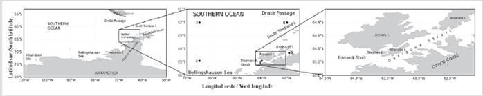
Figure 1 Location of the study area and the reference points. 1) Waters in the Bismarck strait, (64° 54’ S and 64° W). 2) Waters in the southwestern sector of the Southern Ocean, (64° 54’ S and 69° W). 3) Waters in the northwestern sector of the Southern Ocean, (62° S and 69° W). 4) Waters at Drake Passage (62° S and 62° W). 5) Waters in the Gerlache strait, (64°18’ S and 61° 48’ W).
The region’s climate is influenced by topographic elevations that act as a barrier against west-east tropospheric circulation, resulting in a maritime type of climate in the west and colder and drier one in the east. King et al. (2003) state that the WAP is influenced by the Amundsen-Bellingshausen Sea low pressures (ABSL) and by a northwestern flow that brings warmer air masses from the mid-latitudes through synoptic scale systems, obtaining an annual Ta cycle similar to that of maritime regions. The Palmer archipelago is colder than the South Shetland islands. It is the most humid area of the Antarctic, highly glaciated, with glaciers connected to land underneath sea level. Danco coast has a slightly colder weather, and it is the driest in the study area, with less than half the TP of the Palmer archipelago, but also remarkably glacial (Griffith and Anderson, 1989). The pressure systems moving northeast along the WAP coast from the Amundsen Sea carry a high humidity available for precipitation, thus making it the most humid part of Antarctica. The highest average annual TP in the whole Antarctica has been recorded at Dallmann bay, located between the Brabante and Anver islands (Dewar, 1967). Rainfalls and drizzles are common, except during the coldest months of winter, but snow and sleet are the main components of the annual TP, which is related to the passage of cyclonic storms from the Bellingshausen Sea, apparently every three weeks during the whole year (Rundle, 1967). When the storms cease, strong winds from the east and east-northeast begin, bringing large amounts of TP. Katabatic winds are violent and also frequent in the largest bays of Danco coast. These cause the rupture and dispersion of sea ice and icebergs within the bays. Icebergs are formed annually in the southern autumn, at the end of March or beginning of April, when, since they are ice that is still thin and loosely anchored to the shore, they are susceptible to being destroyed by storms or katabatic winds (Krebs, 1983). Circulation in the region suggests a strong connection between the straits and their neighboring seas. From the Bismarck strait, dominated by the modified Circumpolar Deep Water (CDW) (Torres et al., 2020), the waters enter the Gerlache strait. Next, from the Gerlache strait, the waters head north to the Bransfield strait, where they converge with the water from the Weddell Sea (Gordon and Nowlin, 1978). In the western Gerlache, the weak Bellingshausen surface current flows northeast (Mandelli and Burkholder, 1966). According to Amos et al. (1990) and Niiler and Illeman (1990), a superficial flow of waters near the coast of Brabante island heads north and enters the Brandsfield strait by the southwest. However, circulation in this region is complex and probably has seasonal variations, as has been seen in the surface flow of the area (Stein, 1982) and the flow of the Weddell Sea towards the Bransfield strait (Capella et al., 1992, Hofmann et al., 1992). The typical water column of the Gerlache strait consists of an upper layer of Transitional Bellingshausen Water (TBW), a bottom layer of Transitional Weddell Water (TWW), and intermediate intrusions from both the west and the east of the CDW. TBW in the Gerlache strait is colder than in the Bransfield strait due to the freshwater contributions of the local glaciers (García et al., 2002). The freshwater system resulting from the air-sea ice interaction influences the water properties on the surface mixed layer, affecting the stratification of the upper ocean and the region’s ecosystems (Meredith et al., 2010).
MATERIALS AND METHODOLOGY
Meteo-marine variables around the Palmer archipelago
The fields and monthly series of Air Temperature (Ta, °C), Sea Surface Temperature (SST, °C), Wind Speed (WS, m/s), Wind Direction (WD, degrees), Total precipitation (TP, mm), and Sea Ice Coverage fraction (SIC, 0;1) for 1979-2018 were extracted from the fifth ERA-Interim (ERA5) reanalysis generation (Hersbach et al., 2019) of the European Center for Medium-Range Weather Forecasts (ECMWF). ERA5 is the last climate reanalysis produced by ECMWF, which provides data for a large number of atmospheric, terrestrial and oceanic climatic variables. ERA5 includes information on uncertainties for all variables in reduced spatial and temporal resolutions, which are open-access under the License to Use Copernicus Products (v 1.2) from the Climate Data Store (CDS) through the Copernicus Climate Change Service (C3S, 2017). Several studies have performed intercomparisons of the different reanalysis data sets and have arrived to the conclusion that ERA-Interim data are the best at representing the recent Antarctic climate (Turner et al., 2019). Giusti (2021) describes ERA5 in detail, disclosing its coverage and quality of information. The variables extracted from ERA5 for the five points in the waters neighboring Palmer archipelago (Figure 1) are monthly series from 1979 until 2018 (Figure 2).
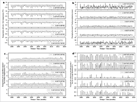
Figure 2 Monthly time series 1979-2018 extracted from ERA5 for five points in the waters around the Palmer archipelago. a) Air temperature (Ta, °C). b) Total Precipitation (TP, mm). c) Sea Surface Temperature (SST, °C). d) Sea Ice Coverage (SIC, 0:1).
To describe the annual behavior, the climatology of the 1979-2018 period was calculated. For the same period, the seasonality of the series was eliminated, and both the multiannual linear trend and the decadal trends (with 95% confidence level) were calculated for the 1981-1990, 1991-2000, and 2001-2010 periods. The horizontal spatial visualization of the variables extracted from ERA5 reanalysis was performed by applying the kriging interpolation method (Paulson and Ragkousis, 2015), using the Gaussian variogram with a 0.3 range and 0.2 anisotropy, obtaining a 0.1ºx0.1º grid. The multiyear annual average of the horizontal fields was calculated to review the current state of the meteo-marine conditions in the study region, and the difference between the fields of the last and first year of the analysis window was obtained in order to spatially identify the sectors where changes in the variables were recorded during these 40 years. The calculations and graphs were made on Python, version 3.7 (Beazley and Van Rossum, 1999).
RESULTS
Multi-year annual average and climatology of meteo-marine variables
The spatial distribution of the 1979-2018 multi-year annual average for Ta (Figure 3a) shows latitudinal isothermals from the northwestern sector of the study area, parallel to the Palmer archipelago up to 64° S. High Ta values (1.59 °C) are located in the northwestern marine sector and the lower ones in the southwestern continental sector on the Antarctic peninsula called Graham Land (-13.18 °C). To the southwest, near the Bellingshausen Sea, the Ta is -3.0 °C, showing a strong longitudinal gradient in the South of this region. Around the Anvers island are isothermals of -5.0 °C, and, north of the Brabante island, there is a Ta of -3.0 °C, which constitutes evidence of local differences between the North (64° 20’ S) and the South (65° S) of the archipelago. Differences between the West (average Ta of -2.5 °C) and the East (isothermals around -7.0 °C) of the archipelago are also observed. The spatial distribution of Ta is coherent with wind displacement. In Figure 3b, to the northwest of the study region, a predominantly northwest wind is observed with an intensity greater than 9 m/s, which transports warm air masses, maintaining its direction up to 64° S. There, over the Palmer Archipelago and the East of the region, a nucleus of low intensity winds is located, preventing the warm western air from mixing with the polar, keeping the eastern sectors colder. Starting at 64° S, between 64° and 70º W, the wind turns southward, taking northwestern air masses to the Bellingshausen Sea at lower speeds.
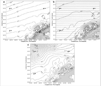
Figure 3 1970-2018 multi-year annual average of Ta (°C), WS (m/s), and SST (°C) around the Palmer Archipelago. 1-5: reference points for temporal description of meteo-marine variables in the waters neighboring the Palmer Archipelago. a) Air temperature (Ta, °C). Isotherm interval 0.5 °C. b) Wind Speed (WS, m/s). Isotach interval 0.4 m/s. c) Sea Surface Temperature (SST, °C). Isotherm interval 0.1 °C.
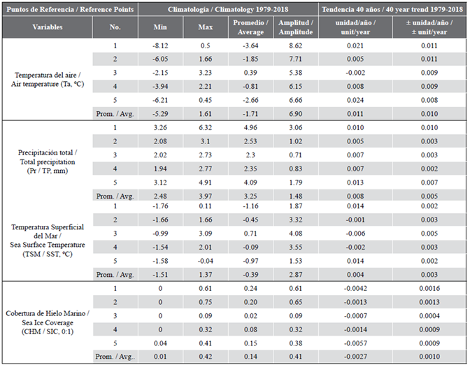
Table 1 Descriptive statistics of climatologies and results of the multiannual linear trend (Significant for the 95% confidence level) for 1979- 2018 period of Ta (°C), TP (mm), SST (°C), and SIC (0:1) at the five reference points. 1) Waters in the Bismarck strait, 64º 54’ S and 64º W. 2) Waters in the southwestern sector of the Southern Ocean, 64º 54’ S and 69º W. 3) Waters in the northwestern sector of the Southern Ocean, 62º S and 69º W. 4) Waters at Drake Passage, 62º S and 62º W. 5) Waters in the Gerlache strait, 64° 18’ S and 61° 48’ W.
In the SST isolines distribution (Figure 3c), as expected, a greater homogeneity is observed in the region, given the inertia of this variable in comparison with Ta. It is noted that values decrease from the northwest, with 1.94 °C, towards the southeast, where they reach -1.58 °C at the Gerlache strait and -1.82 °C in the South of Danco coast and Dallmann bay. In the west and north of the Brabante island, the recorded SST is -1.08 °C, and it is -0.98 °C to the west and south of Anvers island.
Additionally, to corroborate these differences from a temporal perspective, the climatological behavior of Ta, TP, SST, and SIC is shown for the 1979-2018 base period at five selected reference points for the waters surrounding the archipelago (Figure 4), and the descriptive statistics of this climatology are presented (Table 1). The climatology of Ta (Figure 4a) shows a behavior in accordance with the seasonality of the southern latitudes, with high values during summer (DJF) and low ones during the winter (JJA). A difference is highlighted between high Ta values at point 3 (northwestern sector of the study region in the Southern Ocean, with an average of 0.39 ºC) with respect to the low values of point 1 (Bismarck strait with an average of -3.64 ºC). Points 1 and 5, located in waters of the South and North of the archipelago, respectively, show similar Ta (approximately 0.5 ºC) only in the southern summer (DJF), but, in JJA, the difference between the minimum values reaches 1.91 ºC. The TP reports a bimodal climatology, with high values in the southern spring and autumn (Figure 4b). It is observed that the TP is higher at points 1 (south of the archipelago at the Bismarck strait, with an average of 4.96 mm) and 5 (north of the archipelago at the Gerlache strait with an average of 4.09 mm), and its seasonality is more pronounced than at points 2, 3, and 4 (in the southwestern and northwestern sectors of the Southern Ocean and Drake Passage, respectively, with an average of 2.4 mm). This behavior is due to the fact that 2, 3, and 4 are located in offshore marine waters, where the oceanic-atmospheric conditions leading to precipitations are more homogenous, presenting more smoothed TP oscillations. On the other hand, at 1 and 5, the conditions are combined with the effect of the archipelago’s orography, thus causing more precipitations during the year. It is observed that TP values at 1 and 5 are slightly higher during the second semester, which shows the influence of the elevations of the Palmer archipelago during the time of wind intensification.
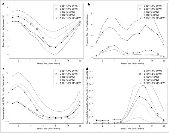
Figure 4 Climatic behavior of the 1979-2018 base period of Ta (°C), TP (mm), SST (°C), and SIC (0:1) at five reference points in the waters around the Palmer archipelago. a) Air temperature (Ta, °C). b) Total Precipitation (TP, mm). c) Sea Surface Temperature (SST, °C). d) Sea Ice Coverage (SIC, 0:1 area fraction).
The SST has a unimodal behavior, with high values in February (an average of 1.37 ºC). Cooling occurs in spring, maintaining negative values (average of minimum values in August of -1.51 ° C) during the following months (Figure 4c). This behavior is similar to that of Ta, with oscillations smoothed due to inertia in the ocean’s response to atmospheric dynamics. There is a persistent difference between high SST values at point 3 (northwestern sector of the study region in the Southern Ocean), with an average of 0.71 ºC, and point 1 (Bismarck strait), with an average of -1.16 ºC. Between the north of Palmer archipelago (point 5, -0.97 ºC average) and the south (point 1), a slight difference is observed, which is intensified at the end of spring and the beginning of the southern summer. During the southern winter, SST values at all points are similar, except for point 3, which is located to the northwest of the region.
The SIC begins to increase during the southern autumn (MAM), reaching values close to 0.6 in August at point 2 (southwestern sector of the study region, in the Southern Ocean), and in September at point 1 (Bismarck strait) due to low Ta and SST. These points, located in higher latitudes, are not so exposed to the warm air masses arriving from the northwest (Figure 3b). Regarding points 1 and 5, the TP during the months prior to the southern winter contributed to the desalinization of surface waters, thus increasing the sea ice covering speed, yet with a difference in the extension observed during the southern summer and spring to the north of Gerlache strait (point 5), where a maximum SIC of 0.41 is reached in August, which is lower than those at points located to the south (1 and 2). Points 3 and 4 report a lower SIC due to their location further north of the study region, where there is a greater influence from the relatively warmer northwestern winds.
Trends of meteo-marine variables in the 1979 - 2018 period
To spatially identify the changes in Ta, TP, and SST during these 40 years, Figure 5 presents the spatial difference between the annual averages of the last and first years of observation (2018 and 1979, respectively). Likewise, in Table 1 and Figure 6, the trends of these parameters at the five reference points to 2018 are presented, and, in Table 2, the decade-long trends 1981-1990, 1991-2000 and 2001-2010 are shown. Positive Ta values can be observed throughout the region (Figure 5a), demonstrating that in 2018 a Ta higher than in 1979 was recorded, with the exception of the southeast of the region over the continental sector in Graham Land and the northwest, over the Southern Ocean, where point 3 shows a negative trend to 2018 of -0.002 ºC/year (Table 1, Figure 6).
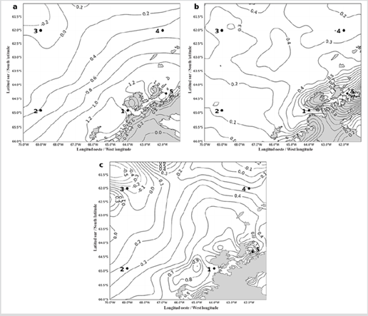
Figure 5 Difference between the annual averages of 2018 and 1979 for Ta (°C), TP (mm), and SST (°C) around the Palmer archipelago. 1-5: points of reference for the temporal description of meteo-marine variables in the waters adjacent to the Palmer archipelago. a) Air temperature (Ta, °C). Isotherm interval 0,2°C. b) Total Precipitation (TP, mm). Isohyet interval 0,1 mm. c) Sea Surface Temperature (SST, °C). Isotherm interval 0,1°C.
Table 2 Linear decadal trend (significant for the 95% confidence level) of the periods 1981-1990, 1991-2000, and 2001-2010 for Ta (°C), TP (mm), SST (°C), and SIC (0:1) at five reference points. 1) Waters in the Bismarck strait, 64º 54’ S and 64º W. 2) Waters in the southwestern sector of the Southern Ocean, 64º 54’ S and 69º W. 3) Waters in the northwestern sector of the Southern Ocean, 62º S and 69º W. 4) Waters at Drake Passage, 62º S and 62º W. 5) Waters in the Gerlache strait, 64° 18’ S and 61° 48’ W.
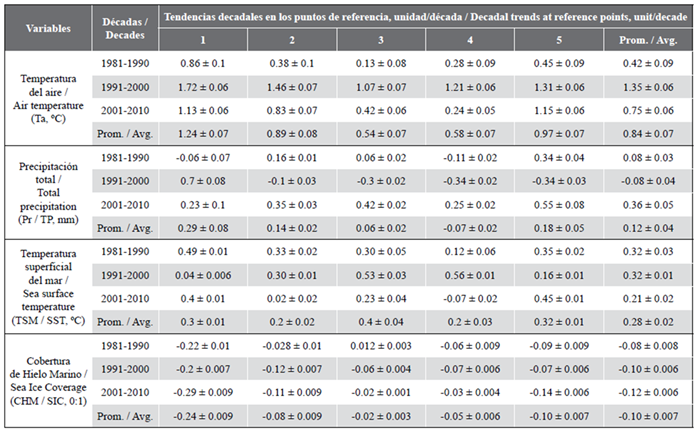
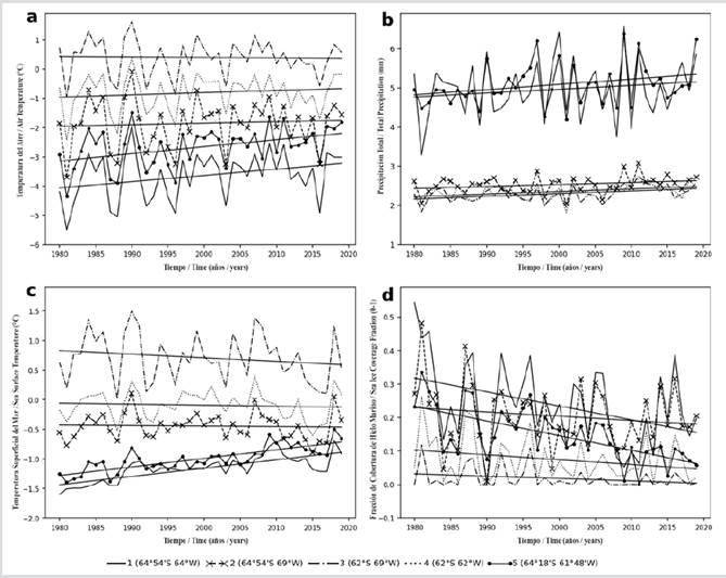
Figure 6 Time series and linear multi-annual trend for the 1979-2018 period of Ta (°C), TP (mm), SST (°C), and SIC (0:1) at five reference points in the waters surrounding the Palmer archipelago. a) Air temperature (Ta, °C). b) Total Precipitation (TP, mm). c) Sea Surface Temperature (SST, °C). d) Sea Ice Coverage (SIC, 0:1 area fraction).
Regarding the decadal trends (Table 2), point 3 also stands out for recording the lowest values among the selected points, being for 1981-1990 a trend of 0.13 ºC/decade, for 1991-2000 of 1.07 ºC/ decade, and for 2001-2010 of 0.42 ºC/decade. Towards the north of Anvers island, positive values around 1.3 ºC are reported. The same occurs in the south of the Palmer archipelago at Bismarck strait, where point 1 is located, with a positive trend to 2018 of 0.021 ºC/year (Table 1, Figure 6), which stands out for reporting the highest trend in 1991-2000 (1.72 ºC/decade) (Table 2). On average, the Ta increases in the region from 1979 until 2018 was 0.47 ºC (Figure 5a). The Ta at point 5 (north of the Palmer archipelago, Gerlache strait) shows the highest trend value towards 2018 (0.024 ºC/year) (Table 1, Figure 6), as well as the highest one during the 2001-2010 period, with 1.15 ºC/decade (Table 2). It should be noted that, in the five reference points, the decadal trends followed a similar behavior, considering that, in 1981-1990, they were positive but lower in comparison with those of 1991-2000, with elevated increase values that decreased again in 2001-2010 (Table 2).
The Ta increase leads to an increase in TP, observed in the isohyets (Figure 5 b) and positive TP trends at all five points (Table 1, Figure 6), thus confirming that the TP in 2018 was higher with respect to 1979. Negative values are observed within a sector limited to 66º S between 64º 30’ W and 65º W. Over the Anvers and Brabante islands, the north of the Gerlache strait, and the western coast of Graham Land, the TP was higher than in the other sectors (Figure 5b). The climatological TP averages at the Gerlache strait reach 4.01 mm, and, at the Bismarck strait, 4.96 mm (Table 1). The highest trend is observed at the Gerlache strait, where point 5 shows a value of 0.013 mm/year, followed by Bismarck strait, where point 1 reports 0.010 mm/year (Table 1, Figure 6).
The distribution of the SST differences between the annual averages of 2018 and 1979 follows the same pattern found in Ta and TP (Figure 5c). The positive values located throughout the region constitute evidence of the increase in SST in recent years, except in the northwest and northeast. A SST increase by more than 0.5 ºC in a wide area is highlighted, which goes from 62º 30’ S to the west of the archipelago with a 0.86 ºC increase, and to the north of the Gerlache strait with 0.76 ºC. SST increases between 0.86 ºC and 0.96 ºC are recorded to the south of the Bismarck strait, spanning all the way to 66º S and 66º 30’ W. Regarding the 1979-2018 trend (Table 1, Figure 6) it is observed that it is positive in the north (Gerlache strait) and south (Bismarck strait) of the Palmer archipelago, with 0.014 ºC/year. The SST trend to 2018 at points 2, 3, and 4 is slightly negative, with -0.001 ºC/year, -0.006 ºC/year, and -0.002 ºC/year, respectively (Table 1, Figure 6), with a perceived increase in the uniformity of SST values in the region, given the value increase in one sector (waters closer to the Palmer archipelago: Gerlache and Bismarck straits) and the slight decrease in another one (waters southwest and northwest of the study region on the Southern Ocean and Drake Passage).
Regarding the decadal trends, it is highlighted in Table 2 for 1991-2018 that points 3 and 4, located in the Southern Ocean, to increase in trends with 0.53 ºC/decade and 0.56 ºC/decade, respectively. For 2001-2010, points 2, 3, and 4 report a decrease in their trends, while these increase at point 5 (Gerlache strait), with 0.45 ºC/decade, and at 1 (Bismarck strait), with 0.4 ºC/decade. In general, the spatial distribution of the difference between the annual averages of 2018 and 1979 for Ta, TP, and SST shown in this work (Figure 5) indicates an increase in these variables during the last 40 years.
The SIC shows negative trends in the 1979-2018 period, evidencing a higher decrease both at the Bismarck strait, with -0.0042 fraction/year, and at the Gerlache strait, with -0.0057 fraction/year (Table 1 and Figure 6). With respect to the decadal trends (Table 2), the south and north of the Palmer archipelago stand out once again, where it is observed that the negative values are higher in 2001-2010, with -0.29 fraction/decade and -0.14 fraction/decade, respectively.
Table 2. Linear decadal trend (significant for the 95% confidence level) of the periods 1981-1990, 1991-2000, and 2001-2010 for Ta (°C), TP (mm), SST (°C), and SIC (0:1) at five reference points. 1) Waters in the Bismarck strait, 64º 54’ S and 64º W. 2) Waters in the southwestern sector of the Southern Ocean, 64º 54’ S and 69º W. 3) Waters in the northwestern sector of the Southern Ocean, 62º S and 69º W. 4) Waters at Drake Passage, 62º S and 62º W. 5) Waters in the Gerlache strait, 64° 18’ S and 61° 48’ W.
DISCUSSION
The differences in Ta described for the surrounding sectors of the study region (Figure 3a) corroborate what was stated by Thomas and Tezner (2019), about the fact that the Antarctic peninsula forms a barrier against strong southwestern winds in the lower troposphere, separating the marine climate of the Bellingshausen Sea from the continental climate on the Weddell Sea side, making this region a unique observation platform to study the climate interaction between the different latitudes in the southern hemisphere. The spatial Ta differences presented in this work confirm what was observed by Carrivick et al. (2019) about the influence of the topography of this sector on the meteo-marine conditions at the regional level. Given that the peninsula has a plateau with ice surface elevations of up to 2000 m between 63° and 67° S, and that, further south at 74° S, it rises to more than 2500 m, the Antarctic peninsula is subjected to subpolar climates in the north and much colder conditions in the south, with contrasting oceanography and meteorology between east-west and large amounts of snow reaching the west because of the winds.
Regarding the isotach distribution, the presence of winds with lower values starting at 64° S (Figure 3b) could be the recurring manifestation of the positive phase of Antarctic Oscillation (AAO), which has maintained the low pressures in the last 40 years according to Goodwin et al. (2016). Positive AAO values (an oscillation that was not studied in this work) are correlated with cold temperatures in most of Antarctica, with the exception of the peninsula, where warm temperatures prevail (Goodwin et al., 2016). On the other hand, in González et al. (2018), the predominance of five cyclonic circulation patterns over the peninsula is identified, and, although most of them are zonal movements of low pressure influencing local characteristics, there are two that present meridional north-south movements, which influence the behavior of meteo-marine variables in the region. The multi-year spatial distribution of SST (Figure 3c) exhibits a pattern similar to that of Ta, showing a differentiation in the conditions surrounding the Palmer Archipelago. Here, lower values are very clearly observed to the east and south, in contrast with those to the west and north of the archipelago, due to the local topography that intervenes in the wind flows and meteo-marine characteristics also observed by Villegas et al. (2018). The climatological behavior of SIC agrees with what was expected as a response of seawater to the dynamics of Ta, TP, and SST (Figure 4d), which leads to the formation of sea ice and its seasonal melting (Jaeschke et al., 2017). In the same way, the SIC average of the five selected points (0.14 area fraction) agrees with that observed by Herr et al. (2019), who indicated that at the regional level, the Antarctic minke whale sighting rate is lower, precisely on the shores of the WAP, given its lower concentration of sea ice.
As for the Ta trends, in the present work, a marked variation was found between the 1981-1990 decade compared to the high values of the 1991-2000 decade, which decreased again in 2001-2010. Turner et al. (2005) found that, at Vernadsky station, the average annual rate of increase in Ta during 1971-2000 was lower than during 1961-1990, and, even though the observation periods are different to those in this work, there is a clear need to thoroughly study the variability of meteo-marine parameters in relation to long-period oceanic-atmospheric oscillations that allow identifying the reason for this behavior. While analyzing the Ta of stations in Antarctica for the 1981-2010 period, Turner et al. (2019) found that these have experienced a positive trend in the annual Ta average throughout the records, with that of Vernadsky being the highest, which is located near this work’s point of reference 1 (Bismarck strait). This point, along with point 5 (Gerlache strait) reported the highest trend values for 1979-2018.
Turner et al. (2019) argue that the AAO variability exerts a great control over the temperatures, influencing the deepening of ABSL as a result of the persistent positive phase of the AAO in the last years. The AAO is not an object of study in this work. However, given its known influence on the region, it is imperative to keep investigating the reviewed variables in the last 40 years, as well as to understand their possible teleconnection with the El Niño Southern Oscillation (ENSO), due to the impact it may cause on the sea ice dynamics, the surface waters physics, and local wind patterns in the region, as has been examined by Kim and Ducklow (2016) and Carrasco (2018). With regards to the spatial differentiation in the behavior of Ta in the WAP region, Turner et al. (2005) identified a marked warming from the southwest of the Antarctic peninsula, through Vernadsky station and the tip of the peninsula, to the South Shetland islands, with a decreasing warming rate towards the north of Vernadsky. This aspect was also observed in this work with the found Ta trends, which allowed corroborating the local difference of the study area. The same was observed by Stastna (2010), who calculated trends with Ta series along the Antarctic peninsula, showing that, in the southern sector of the WAP corresponding to Vernadsky station, a high trend value of 56 °C/decade was reached, which is equivalent to a 2.97 °C increase during 54 years (1950-2003), and a lower increase was recorded in the north of the WAP at O’Higgins station with 0.18 °C/decade, corresponding to 0.77 °C during 43 years (1961-2003). Turner et al. (2005) have observed the association between atmospheric circulation in the Antarctic peninsula and ENOS events (not studied in the present work), noting that these can cause a tropical influence on climate changes in the region, with warm events causing high pressure upon the ABSL system, thus leading to cold conditions and forcing of the south winds over the Antarctic peninsula, a mechanism whose analysis is advised, while also considering other factors that control the peninsula’s Ta and SST. The negative SST trends on the waters of the Southern Ocean (points 2 and 3) and Drake Passage (point 4) in 1979-2018 may be associated with the effect analyzed by Ferster et al. (2018), who found significant spatial correlations related to the AAO with SST observations derived from satellites in 1982-2016 and global teleconnection indices.
As for the years following 1991, Verona et al. (2019) present the results of observational and modeled SST data sets after the eruption of the Pinatubo volcano, showing a similar warming pattern for the Antarctic Peninsula, although with differences in the magnitude of the anomalies. The SST warming response of the Antarctic Peninsula started in the first year after the eruption and lasted until 1993. It is worth mentioning that, even though the warming in the Antarctic peninsula after the eruption was observed in all data sets in Verona et al. (2019), the warming is not exclusive to this region, and the contribution to the internal climate variability of the study area must be subjected to a continuous and detailed analysis with different data sets. The increase in Ta, TP, and SST in the last 40 years shown in this work was also seen by Szumińska et al. (2018), who associate the warming trend in the peninsula during the last 50 years to the change in the atmospheric circulation patterns of the southern hemisphere.
Recent studies on SIC indicate marked regional changes both in the extension and concentration of Antarctic sea ice and the sea temperatures close to the surface throughout the Antarctic continent. In the SIC trends for the selected reference points of this study, negative values are evidenced (Tables 1 and 2 and Figure 6d), which agrees with Fogt and Wovrosh (2015), who claim that the area of the Amundsen-Bellingshausen seas has experienced a decrease in the extension and concentration of sea ice in the last decades, while the opposite occurs in the Ross Sea. What was observed in this work confirms what was seen by Moreau et al. (2015), who, studying the presence and abundance of certain phytoplankton groups, demonstrated that the Gerlache strait is being affected by the early sea ice retreat and the increase in SST. According to Cook et al. (2016), about 90% of the glaciers in the WAP are being reduced, as well as the extension of sea ice and its mean duration, reaching approximately 90 days (Stammerjohn et al., 2012). Laffin et al. (2021), conducting research on the influence of the warm and dry föhn winds on the melting of the surface of ice platforms in the Antarctic peninsula for 1979-2018, found that the trends and evolution of long-term fusion induced by föhn can be attributed to seasonal changes; During the last 20 years, the highest occurrence of föhn happens in summer, with a decrease in autumn, winter and early spring, which matches the SIC decadal trends shown in this study, especially for the points located at the south and north of the Gerlache strait.
It is clear that Antarctica shows a regional differentiation in its response to climate change and variability; that the Antarctic Peninsula stands out for its vulnerability to these processes, especially the WAP, where local differences are also observed; and that, according to this research, the Gerlache strait stands out for the differential behavior of its meteo-marine conditions. The climate and climate variability of the study region is a complex combination of factors, from mountain winds to larger spatial-scale atmospheric and oceanographic patterns, as well as their long-term trends. There are still several gaps in the understanding of the response of the marine sectors that constitute the Antarctic peninsula to climate variability and climate change, thus posing questions that will have to be answered with the continuity of national and international observation and research programs.
CONCLUSIONS
The spatial distribution of the multi-year annual average of meteo-marine variables for the 1979-2018 period indicates a local differentiation between the north (Gerlache Strait) and south (Bismarck Strait) of the Palmer archipelago and between the eastern coast (Gerlache Strait) and western waters (Southern Ocean) of the archipelago. The climatological behavior (1979-2018) of Ta north of the Gerlache and Bismarck straits is similar during the southern summer, but it may exhibit differences in winter, with Ta being the lowest at the Bismarck strait. The TP is higher north of the Gerlache and Bismarck straits, in comparison with the behavior of TP in other open-sea sectors in the study region. Between these two straits, there is a slight difference in SST, which is accented since the southern summer, when the SST is higher to the north of Gerlache. The differences between the 2018 and 1979 annual averages show that Ta, TP, and SST have experienced a general increase in the last 40 years in the study region. From the selected reference points, it was evidenced that in 1979-2018, there is a slight negative trend of Ta to the northwest of the study area in the Southern Ocean with -0.002 °C/year; and for SST in the southwest and northwest of the Southern Ocean and in the Drake Passage, with values of -0.001 ºC/year, -0.006 ºC/year, and -0.002 ºC/year, respectively. The TP showed positive trends. The highest increase values for Ta, TP, and SST were recorded to the north of the Gerlache strait, followed by the Bismarck strait. It was evidenced that the SIC exhibits negative trends during the 1979-2018 period, showing a higher decrease in SIC at the Bismarck strait with -0.0042 fraction/year, and in the Gerlache strait with -0.0057 fraction/year. The rate of change during the 1979-2018 period observed at the five reference points for Ta is of 0.011 ºC/year; for TP, it is 0.008 mm/year; for SST, it is 0.004 ºC/year; and for SIC, it is -0.003 fraction/year. The decade 1991-2000 stands out for presenting high trend values of Ta for the five reference points, with an average of 1.4 °C/decade. The highest PT trend values were recorded in 2001-2010 with an average of 0.4 mm/decade. The highest SST decadal trends were observed in 1981-1990 and 1991-2000 with 0.3 ºC / decade. In the three decades (1981-1990, 1991-2000, and 2001-2010), the SIC decrease was -0.1 fraction/decade.

