


 text in
  English (pdf)
 Article in xml format
 Article references
 Send this article by e-mail
 Cited by SciELO
  Cited by Google
  Similars in
SciELO
Similars in
SciELO  Similars in Google
 Permalink
INTRODUCTION
The global average sea level is rising. The sum of the glaciers and ice layers’ contributions is now the predominant source of the increase (IPCC, 2019). It is predicted that the rise in the sea level will be around 65 cm by 2100 (Nerem et al., 2018). The fifth assessment report of the IPCC considers a very high-emissions scenario and predicts a global rise between 52 and 98 cm for the end of this century. This increase is expected to continue for centuries, even if greenhouse gas emissions are reduced and the atmospheric concentrations are stabilized (IPCC, 2014).
Severe impacts are currently being observed in coastal regions, which is due to the sea level rise. The most drastic consequences of this phenomenon are erosion, which results in the permanent flooding of coastal areas; a decrease in the quality of water; a decrease in fish farming; the intrusion of seawater in freshwater resources; and the flooding of wetlands and estuaries (Koroglu et al., 2019). Among the impacts expected in coastal ecosystems due to this sea level rise are the contraction of the habitat, the loss of functionality and biodiversity, and lateral and interior migration (IPCC, 2019). The coastal zones, which are mostly low and densely populated, would be subjected to accelerated erosion, in addition to the intrusion of salt water in coastal underground aquifers, thus threatening historical and cultural resources as well as the infrastructure (Pendleton et al., 2004).
The erosion conditions along most of the Antioquia littoral and its high vulnerability due to factors such as the sea level rise have been broadly documented in papers and press statements. This includes publications by Corpourabá-Universidad Nacional de Colombia and numerous academic studies (Corpourabá-Universidad Nacional de Colombia, 1998; Invemar, 2003; Correa and Vernette, 2004; Correa et al., 2005; Posada and Henao, 2008; Prussmann, 2011; Paniagua, 2013; Rangel and Anfuso, 2015; Correa and Paniagua, 2016).
The presence of emerging and inclined marine terrace levels in the Southwest of the Colombian Caribbean evidences strong tectonic deformations leading to differential terrain lifting that most likely fosters littoral erosion. Changes in land-sea levels associated with eustatic increases in the sea level and hydro-isostasy (lifting of the emerging coast and subsidence in the marine platform) are also important factors in this context (Vernette et al., 1992; Invemar, 2003; Correa y Vernette, 2004).
Another factor that is worth highlighting corresponds to the deficient geotechnical conditions of the rocks along the Antioquia coast, which is composed through most of its length of siltstones and claylites with high degrees of physical and chemical alteration. These rocks and their associated soils are little resistant to the physical action of water (waves, rains, and runoffs), and their dense fracturing, with inclinations (dips) towards the sea, allows for high percolations of rainwater and wastewater. The above facilitates and fosters cracking, the generation of gullies, and mass movements, particularly debris flow and rockfall along the coastline (Correa and Vernette, 2004).
The placement of more than 160 groyne along the coastline, structures of different dimensions and built during the last decades with bagcretes, rocks, and pentapods/hexapods located perpendicular to the coastline, are interpreted as the most important accelerating factors of the erosion along the coastline, given that they have interrupted the transit of sands, thus generating erosion or accelerating the one that preexisted in adjacent sectors. In a few decades, they have been mostly responsible for the critical situations currently being experienced in sectors such as Arboletes, Damaquiel, Zapata, Necoclí, El Totumo, and Turbo. The intensive extraction of sand and gravel from the beaches in areas close to the coastline should also be considered, which cannot be quantified due to a lack of records. As an additional fact, the pollution caused by wastewater is noted, as well as that caused by mining and intensive agricultural crops (Vallejo Toro et al., 2016). All of the above has led to classify the coastline of the Antioquia littoral into very low landscape and beach quality categories (Rangel-Buitrago and Posada, 2013).
Along the Antioquia littoral between Necoclí and Turbo, intense changes in the coastline have been identified (Aristizábal et al., 1990; Corpourabá-Universidad Nacional de Colombia, 1998). The main aspects of these works were summarized and updated in Correa and Vernette (2004), as well as in maps and the geomorphological schemes of the Antioquia littoral. The cited documents contain the microtidal nature of the area (astronomic tides with maximum amplitudes of approximately 40 cm) and the net transport of sandy sediments towards the south, which is associated with the incidence of drought-time winds (N and NE, from November to March), with inversions towards the north during the incidence of the southern (S) winds in the rainy season.
The semiquantitative inventory of littoral erosion and accretion, based on comparisons of aerial photographs taken by Igac between 1940 and 1985 (expressed as coastline advancement or recession ratios in m/year), evidences the prevalence of erosion tendencies across the whole littoral (Correa and Vernette, 2004). The maximum erosive tendency (20 m/year) was identified in the distal end of the Punta Las Vacas spits (Gobernación de Antioquia - Universidad de Antioquia, 2018). In the same way, the last systematic determinations of the changes in the coastline between the delta of the Turbo River and the end of the Punta Las Vacas spike for the period between 1959 and 2010 estimate erosion values for the northern and central beaches of the spike in the order of 116-174 m (Gobernación de Antioquia-Corpourabá-Invemar, 2010; Paniagua-Arroyave, 2013). Consequently, vulnerability and its impact on the economies of countries with coastlines make it necessary to evaluate the sea level rise and, in turn, to formulate fitting response strategies for these changes (Vafeidis et al., 2008).
The concept of vulnerability is explained in diverse ways by experts of different disciplines. In this case, vulnerability is associated with the sensitivity of an ecosystem (the degree in which it may be affected in terms of its exposure) to a phenomenon (sea level rise) and/or its adaptation capabilities (Ojeda et al., 2009). One of the simplest and most commonly employed methods for evaluating coastal vulnerability is the Coastal Vulnerability Index (CVI), which was initially developed by Gornitz and Kanciruk (1989) with the purpose of developing a database of coastal hazards in order to provide a global perspective on the relative vulnerabilities of the world’s coasts against the dangers of flooding and erosion associated with the sea level rise. To calculate this index, Gornitz and Kanciruk (1989) used the following variables: coastal geomorphology, the regional coastal slope, the relative change in the sea level, the mean significant wave height, the historical change rate of the coast, and the mean amplitude of the tides.
The CVI has been applied and adapted for evaluating coastal vulnerability in different regions around the world (for example: Gornitz, 1991; Shaw et al., 1998; Thieler y Hammar-Klose, 1999, 2000; Pendleton et al., 2004: Boruff et al., 2005; Doukakis, 2005; Diez et al., 2007; Nageswara Rao et al., 2008; Ojeda et al., 2009; Abuodha and Woodroffe, 2010; Ozyurt and Ergin, 2010; López et al., 2016; Ramos et al., 2016). The results of the CVI can be used to highlight the regions where the sea level rise contributes to coastal changes which may have a greater potential to contribute to changes in coastal recession (Gutiérrez et al., 2009). In this article, coastal vulnerability is evaluated in light of the sea level rise and for critical sectors of the southwestern coast of the Colombian Caribbean by means of the CVI.
STUDY AREA
The Gulf of Urabá is located in the southwestern Colombian Caribbean (Figure 1), between 7° 55’ and 8° 40’ N, and between 76° 53’ and 7° 23’ W. It is approximately 80 km long and 25 km wide, and it has shallow depths, with averages of 30 m and maximum values of 80 m at the border in the north (Montoya and Toro, 2006). The Gulf’s hydrodynamics are influenced by the seasonal variation of the fluvial discharge of the Atrato River, the position of the ITCZ, the waves, the tides, and the density gradients (Escobar et al., 2011).
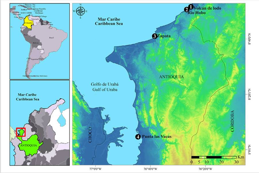
Figure 1 Location of the four study sites in the southwestern Colombian Caribbean: 1) Volcán de Lodo, 2) Hobo River, 3) Zapata, and 4) Punta Las Vacas
The northern (Volcán de Lodo) and southern (Hobo River) sectors of the municipality of Arboletes exhibit an accelerated marine erosion, which is probably due to the effect of the waves reaching the escarpment of the marine terrace and undermining it, thus eroding the less-resistant inferior sediment strata through the formation of a series of cavities that eventually cause the detachment of the superior portions of the terrace. Moreover, the superior part of the terrace undergoes expansion and contraction processes in the clay material present in the soils, which causes a loss of cohesion in the soil structure and later dragging. This marine erosion problem has been the object of several development plans by the last governments of Arboletes (PDM 2008-2011. 2012-2015, 2016-2019).
Zapata also shows erosive processes, which have determined the implementation of protective works such as levees and rock walls (revetments) (Corpourabá-EAFIT, 2015) in order to mitigate the energy of the waves reaching the base of the terrace. However, towards the southwest of the levees, the terrace is still being strongly eroded by the action of the waves that impact the base of the cliff, undermine it, and cause a loss of support in the overlying stratum given the weakness of the basal stratum. In the Punta Las Vacas spike, the external front started to erode in the 1940s. This process has gradually expanded across the entirety of the beaches in this sector, thus generating estimated recessions of 70 m in some areas during the last 80 years (Invemar, 2003).
MATERIALS AND METHODS
Coastal vulnerability was evaluated by means of the CVI, which integrates six variables (Ojeda et al., 2009). The CVI allows the variables to interact in a quantifiable way and expresses the relative vulnerability of the coast to physical changes caused by the future sea level rise. Said index is calculated as the square root of the product of the classified variables, which is divided by the total number of variables. Once these six variables were incorporated into the GIS, the results were integrated according to the following equation:
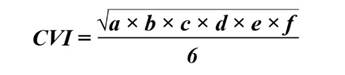
where a represents the geomorphology, b the coastal slope, c the coastline change rate, d the mean significant waves, e the sea level change rate, and f the tidal range. This method yields dimensionless numerical data which do not correspond to any physical magnitude. However, it allows identifying areas where the diverse effects of the sea level rise may be greater. The CVI presented herein is similar to that used by Gornitz and Kanciruk (1989), Gornitz (1991), Shaw et al. (1998), Thieler and Hammar- Klose (1999), and Ojeda et al. (2009).
Given that the variables employed by the CVI are both quantitative and qualitative, with different scales and units, their classification was assigned a value from 1 to 5 for their integration (Table 1). Table 1 also indicates the source of the data and the period of time used to obtain the values of each variable. Value 5 represents the class with the greatest vulnerability, and value 1 corresponds to the lowest one.
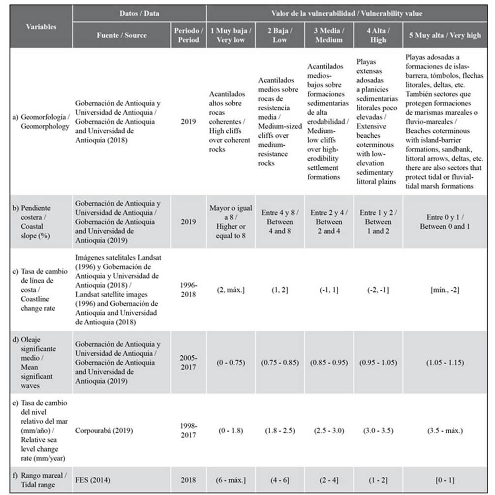
Geomorphological classification was carried out through photointerpretation and corroborated via field visits. The coastline was defined every 100 m by means of polylines in order to determine the vulnerability value of each area. The primary information was processed in ArcGIS 10.5. The slope was obtained from topographic and bathymetric mapping by means of the “slope” tool through the 3D Analyst tool - Raster Surface path in ArcGIS 10.5 (Gobernación de Antioquia and Universidad de Antioquia, 2018). The slope percentage was calculated as the quotient between the elevation difference and the horizontal distance traveled.
In turn, the coastline change rate was obtained by analyzing the evolution of the coastline between 1996 and 2018. The coastlines corresponding to 1996 were determined via Landsat satellite images (1996). This type of image is also used in previous documents, given that there are no images of the region with better quality (Correa et al., 2007; Rangel et al., 2015). The images corresponding to 2018 were obtained via drone flights at all sites except Punta las Vacas (Gobernación de Antioquia and Universidad de Antioquia, 2018). At this site, it was not possible to fly the drone because of the presence of a signal inhibitor, which is why we proceeded similarly to the way in which we obtained the coastlines for 1996. The effects of the waves were not considered, since no storm conditions were observed in any of the aerial photographs. The coastline change rate (m/year) was evaluated by drawing semi-automatized perpendicular transects between the current baseline and the coastlines obtained from historical information. Coastline changes were analyzed using the DSAS (Digital Shoreline Analysis System) software. This tool calculates statistical parameters indicating the status and evolutionary tendencies of specific periods of time (Thieler et al., 2005).
Aiming to represent the best mean significant wave conditions, the WaveWatch IIITM model was used from the Caribbean Sea to the Gulf of Urabá with multiple 1/6°, 1/12°, and 1/60° nested meshes (Gobernación de Antioquia and Universidad de Antioquia, 2018). To summarize, a sensitivity analysis with different mesh sizes was performed, and the energetic influence of the waves coming from the northern Atlantic to each site was determined. To assess the relative sea level change rate, data regarding anomalies in the sea level between 1994 and 2007 were used, thus obtaining the sea level rise rates in the Colombian Caribbean for six coastal cells of the Gulf of Urabá between 1998 and 2017 (20 years) (Corpourabá, 2019).
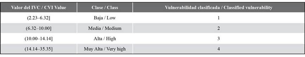
On the other hand, the tidal range of the Volcán de Lodo, Hobo River, and Zapata sites was determined by using the FES2014 model. For Punta Las Vacas, data from the tide gauge located at the Coast Guard station of the Turbo Naval Base were employed. These were modeled through the harmonics analysis method (Higuita and Quintana, 2020). Once all the variables had been evaluated in 100 m * 100 m grids, the relevant calculations were performed for each area, and the results obtained were divided into four classes, using the 25, 50, and 75 % percentiles as limits, as well as by applying the classification by Ojeda et al. (2009), as indicated in Table 2.
RESULTS
While analyzing the response of the southwestern coast of the Colombian Caribbean to the sea level rise, little variability is found among the data obtained, given that the dimensions of the analyzed coastline sections are smaller than 3 km. The Volcán de Lodo, Hobo River, and Zapata sites share some of their vulnerability classifications, given that their geographical location is outside the Gulf of Urabá. As a group, the vulnerability values for these sites are different from those obtained for Punta Las Vacas. Next, the results obtained for each of the variables employed for calculating the CVI are presented.
The geomorphological classification of the Volcán de Lodo, Hobo River, and Zapata sites predominantly comprises clips over high-erodibility sediment formations. This constitutes a medium vulnerability. In Punta Las Vacas, beach formations constitute a high level of vulnerability
Volcán de Lodo and Zapata predominantly comprise high slopes that reach values of 63 %. Both sites are classified as having low and very low vulnerability. The low slopes of Hobo River and Punta Las Vacas, which have values close to 2 %, are classified within the index with a medium to very high vulnerability level
The coastline change rate in Volcán de Lodo, Hobo River, and Zapata shows values of up to 4 m/year, thus constituting very high vulnerabilities (Figure 2). Punta Las Vacas reaches recessions of up to 9,8 m/year. The most effective part is the center, where there used to be a landing strip, but it is nowadays divided in two parts due to coastal erosion
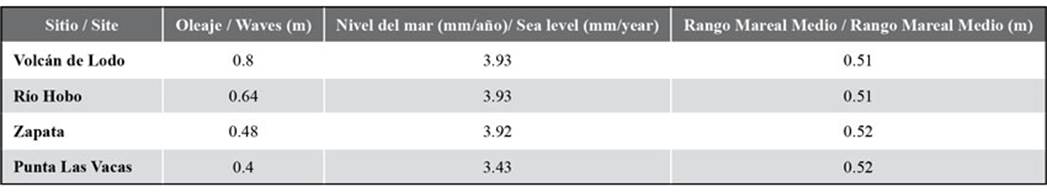
The mean significant waves were lower than 0,85 m in all the studied sites (Table 3) (Gobernación de Antioquia - Universidad de Antioquia, 2018), which is why it was classified as having a low vulnerability
As for the relative sea level change rate, all sites are above 3 mm/year (Table 3) (Corpourabá, 2019), thus constituting high to very high vulnerabilities
The tidal range does not exceed 0,52 m at any of the studied sites (Table 3), which constitutes a very high level of vulnerability
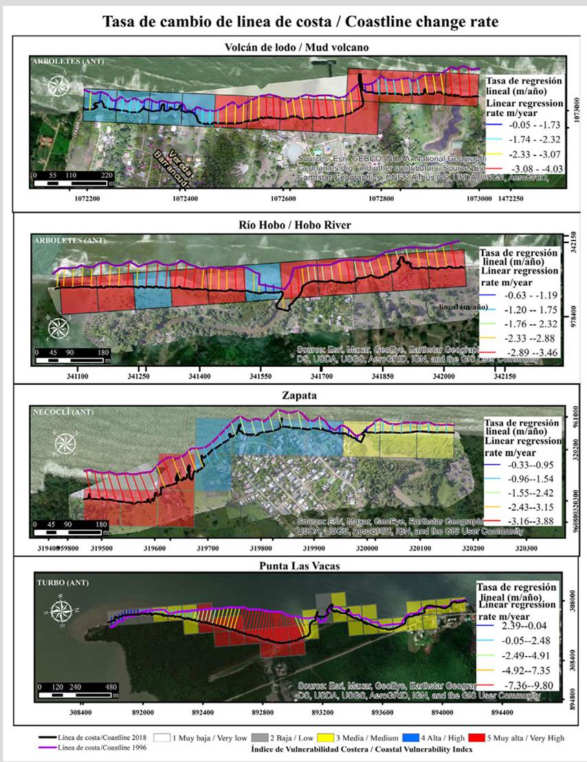
Figure 2 Coastline change rate in Volcán de Lodo, Hobo River, Zapata, and Punta Las Vacas. WGS 1984 UTM coordinate system, 18N zone, Transverse Mercator projection, units: meters, 100 * 100 m grids. Ortophotos taken from the research project for the reversal of erosion in the coasts of the Antioquia Sea, Ascon 18-41, topo-bathymetry component (2018).
Table 3 Physical variables: waves (Gobernación de Antioquia - Universidad de Antioquia, 2018), sea levels (Corpourabá, 2019), mean tidal range (Higuita and Quintana, 2020)
The CVI values were found to be between 7.07 and 28.86. 62 % of the coastline of Volcán de Lodo has a very high vulnerability, which is associated with cliff areas with erodible sediment formations and high coastline recessions, whereas the remaining 38 %, where the vulnerability is high, comprises places with small coastal defense works (Figure 3).
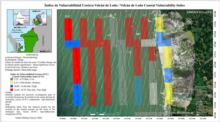
Figure 3 Variables: a) geomorphology, b) slope, c) coastline change rate, d) mean significant waves, e) relative sea level change rate, f) mean tidal range, and, finally, the CVI value for the coastline of Volcán de Lodo (left).
73 % of the area in Hobo River has a very high vulnerability, mainly at the river mouth and the neighboring mangrove zone, where the beach formations are located. The remaining 27 % has a high vulnerability and corresponds to cliff areas (Figure 4).
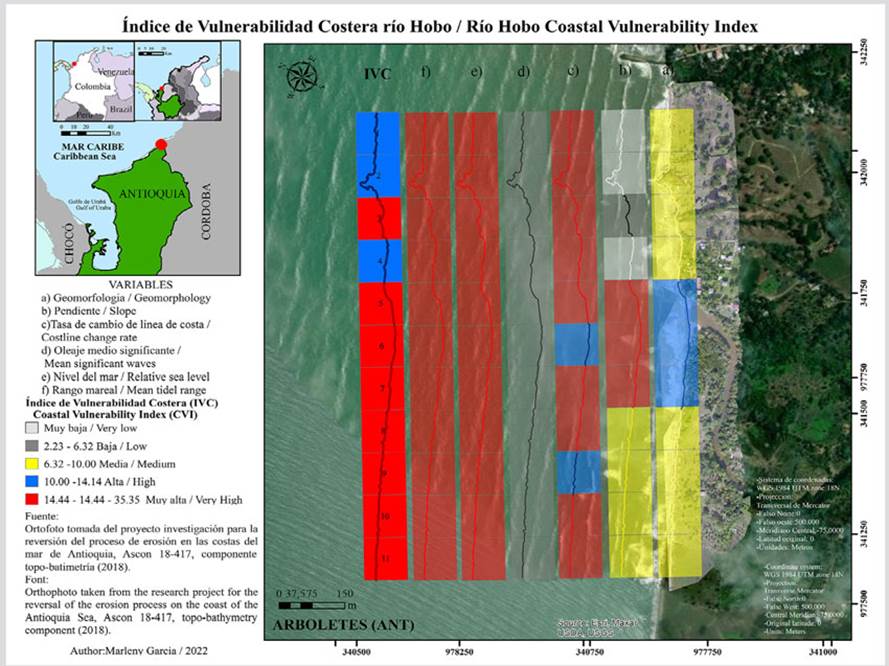
Figure 4 Variables: a) geomorphology, b) slope, c) coastline change rate, d) mean significant waves, e) relative sea level change rate, f) mean tidal range, and, finally, the CVI value for the coastline of Hobo River (left).
In Zapata, 8 % of the coast has a very high vulnerability, which is associated with the river mouth, mainly due to the slope parameter. Meanwhile, 92 % shows a medium vulnerability, which corresponds to the sections with coastal protection works (Figure 5).
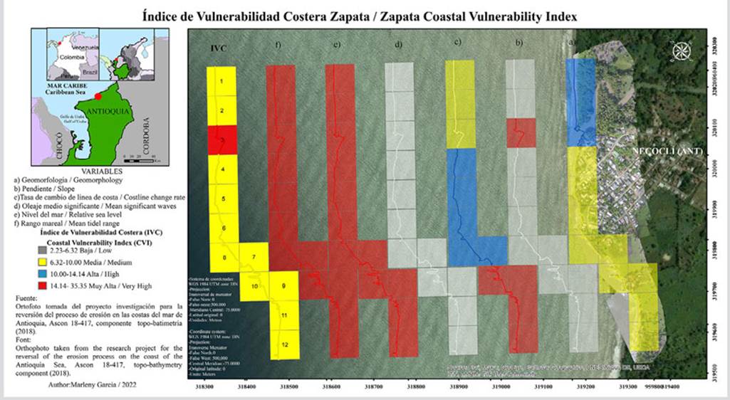
Figure 5 Variables: a) geomorphology, b) slope, c) coastline change rate, d) mean significant waves, e) relative sea level change rate, f) mean tidal range, and, finally, the CVI value for the coastline of Zapata (left).
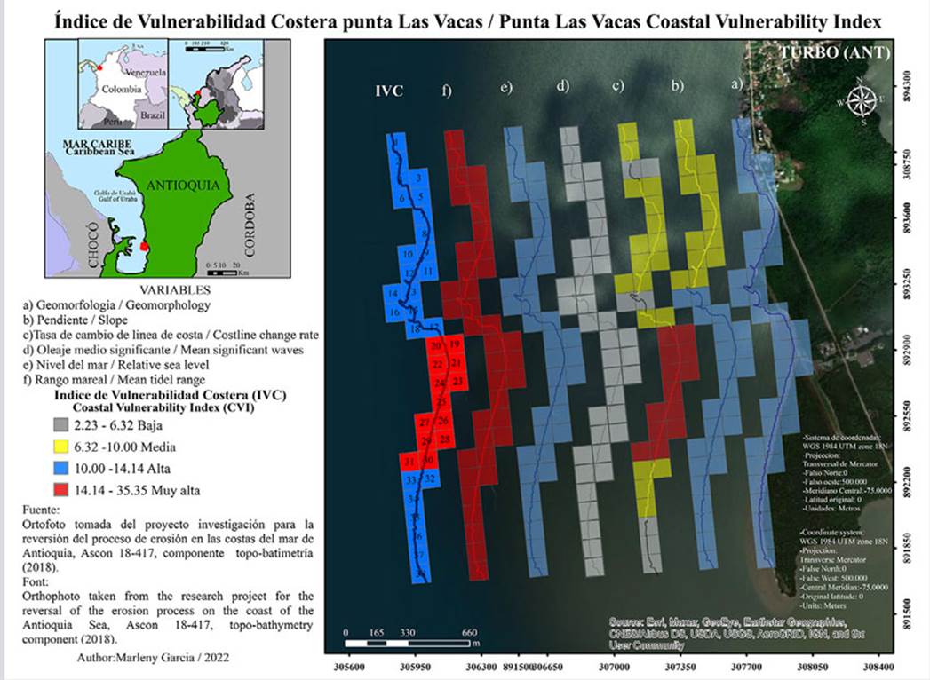
Finally, in Punta Las Vacas 63 % has a very high vulnerability, with erosive processes especially in the central sector of the spike. The remaining 37 % shows a high vulnerability (Figure 6).
DISSCUSSION
Studies carried out with the CVI contemplate different numbers of variables. Gornitz (1991, 1994), one of the pioneers of the index, contemplates the use of seven to thirteen variables in the eastern coast of the United States. In their work on the coasts of Canada, Shaw et al. (1998) consider seven variables, whereas Nageswara et al. (2008) considered the importance of only five variables for the coasts of India. On their part, Ojeda et al. (2009) included six variables for the coasts of Spain. It is important to analyze which variables are relevant for each coastal zone according to its dynamics, even though, as shown by these previous studies, the number of variables also depends on the amount of available information.
This work analyzed a total of 8 km of coastline. The IVC values were found to be between 7.07 and 28.86. 80 % currently have a high vulnerability, mostly low coastal sectors near river mouths, which are characterized by the presence of mangroves, erosive coasts with high recession rates, with similarities found with places such as Mar Chiquita in Argentina (Fernández et al., 2018) or Cartagena de Indias in Colombia, with a very vulnerable littoral, which is mainly associated with coastal recession and anthropogenic occupation (Rangel and Posada, 2013). It is possible that some high-vulnerability zones are associated with the negative impact of badly implemented coastal protection works.
The mangroves located in the study areas are associated with small rivers, streams, or coastal depressions. Said mangroves are threatened by progressive coastal erosion and, and it is even predicted that, in a great portion of the Antioquia littoral, small mangrove areas located in places with a sediment contribution deficit will disappear (Blanco-Libreros, 2016).
Erosion conditions along most of the Antioquia littoral, as well as the high vulnerability due to factors such as the sea level rise, have been broadly documented in articles and press statements. This includes publications by Corpourabá-Universidad Nacional de Colombia and numerous academic studies (Corpourabá-Universidad Nacional de Colombia, 1998; Invemar, 2003, 2007; Correa and Vernette, 2004; Correa et al., 2005; Posada and Henao, 2008; Torres-Parra et al., 2008; Rangel and Anfuso, 2009; Prussmann, 2011; Paniagua, 2013; Rangel et al., 2015; Correa and Paniagua, 2016). The sea level rise in the study areas can reach 3,93 mm/year (Corpourabá, 2019). These values are low in comparison, for example, with cities such as Cartagena, where the levels start at 5.3 ± 1.3 mm/year (Torres- Parra, 2008), or with the Gulf of Mexico, where these values start at 1.8 ± 9.2 mm/year (Zavala et al., 2011). One of the only works that specifically dealt with the variation in the mean sea level in the study area reports an increase of ~19.4 mm/year for the period between 2011 and 2015 (Londoño and Murillo, 2018). However, the impacts are not the same in all coasts, given that there are different processes such as natural subsidence, sediment contributions, high human pressure, and protected zones with coastal infrastructures such as geotubes, breakwaters, and jetties. In the particular case of the southern Caribbean, a land subsidence in the order of 4 mm/year is reported in the coastal terraces, which is due to sedimentation and compressive tectonics (Blanco-Libreros, 2016). Other opinions with regard to the Caribbean Sea basin conclude that it seems to be dominated by subbasins and local processes, and, therefore, global and even regional estimations are not sufficient for providing planning and coastal protection guidelines or for estimating the coastal vulnerability in light of the sea level change (Torres-Parra and Tsimplis, 2013).
None of the studied sites obtained a low vulnerability given the high erosion rates of the last decades, which may also be an indicator of the sea level rise in this area. If said rise continues until it reaches ~65 cm in 2100 (Nerem et al., 2018), it is likely that the herein analyzed coasts will be drastically eroded.
On the other hand, the coastline recessions in the studied area vary between 4 and 9.8 m/year. These values are similar to the 2.5-11 m/year obtained for the coast of Tabasco, Mexico (Hernández et al., 2008). Caleta Portales, Chile, recorded a 12.6 m recession between 2004 and 2016, which was caused by a slight coastal change (Martínez et al., 2018). In the case of Hobo River and Zapata, the river mouths show a very high vulnerability; the ecosystems of said river mouths have already been found to be vulnerable to the sea level rise (Grupo Intergubernamental de Expertos sobre el Cambio Climático, 2001).
The geomorphological composition of the region, as described by Correa and Vernette (2004), indicates that Volcán de Lodo, Hobo River, and Zapata are part of an “open coast” system and that their morphology is dominated by emerged marine terraces. On the contrary, Punta Las Vacas is part of a “semi-protected” coast sector, which is dominated by low marine terraces that are interrupted by beaches, beach strands, and spits.
Historical records of Volcán de Lodo report erosive problems since the 1960s, with the near disappearance of the Punta Rey peninsula, thus unfolding a sequence of erosive processes that reached erosion rates from 7 to 40 m/year and coastline recessions in the order of 50-100 m (Correa and Vernette, 2004). Erosion in this sector is influenced by two main factors. The first is the effect of the trade winds arriving to the region during the dry season, thus causing strong waves that erode the area, which are evidenced by the formation of gullies and bays. Toro et al. (2019) suggest that the direction and intensity of the wind in different climate epochs of the year modulate circulation in the studied areas, where variations in circulation at a spatial level are more significant. The authors state that the wave conditions should be analyzed in three zones within the Gulf of Urabá: north, center, and south (in light of the particularities of each one).
The other erosive process corresponds to the action of runoff and underground waters, which generate a sediment material wash and, at times, land subsidence and creeping mass slides. This happens particularly during the summer; as they are mainly composed of expansive clays, the soils contract due to intense heat, causing cracks due to water evaporation. On the other hand, during winter, they expand precisely because of the rains infiltrating the cracks as they worsen the terrain, which generates a considerable loss of sediments (Serna, 2020). These recessions have caused the loss of households, crops, and touristic sectors, thus affecting the inhabitants’ economy. The current and most dire concern is that of Volcán de Lodo, which is within a slope with high erosive processes due to wave and runoff activity. The DAPARD took action in 2020 with the construction of three sandbanks, with which it intends to mitigate the erosive impact in this sector as well as to strengthen its touristic activity.
In turn, the vulnerability status of Punta Las Vacas corresponds to the fact that it is the place that reports the highest coastal erosion. Since 1940, its erosion rates are directly related to the development of the spike of the Turbo river delta in the north, whose river mouth within the Turbo bay was artificially diverted in 1954. This erosive process gradually intensified until it affected the entirety of the beaches and generated coastline recessions estimated to be around 70 m in some sectors (Correa and Vernette, 2004; Correa et al., 2005) while an intense aggrading at the new lobe of the delta outlet took place (Alcántara-Carrió et al., 2019).
Given the presence of deltas at the studied sites, it is recommended that measurements be made at different times in order to analyze the slope variable, as they can significantly influence the calculations regarding the vulnerability status. Finally, the Gulf of Urabá has a microtidal, semidiurnal regime (Restrepo and Correa, 1994). On the contrary, major tidal ranges dissipate the wave energy, thus limiting active erosion to high-tide periods (Gornitz et al., 1994). On the other hand, in their study on Mexican costs with microtidal regimes, Ramos et al. (2016) believe that this variable has no influence on the CVI and that it could somehow be omitted or replaced by another one.
CONCLUSIONS
The physical wave activity, sea level rise, and tidal range variables show little variability due to the shortness of the studied coastline sectors. The variable with the least incidence on the coastal vulnerability index is wave activity, whereas the tidal range and the sea level rise were the most significant.
According to the CVI, the areas of higher vulnerability are consistent with the high coastline change rates and the river mouths. 85 % of the coastlines included in this study have high to very high vulnerabilities. The coastal areas with medium vulnerability levels are associated with coastal protection works.
The vulnerability of the southwestern Colombian Caribbean to the sea level rise is evident. The maps shown in this document indicate where the physical changes within the coastline are taking place as the sea level continues to rise. In the future, adapting this methodology with more continuous information shall provide more accurate data on predicted impacts, and it will be the basis for understanding the littoral modifications, so that strategies can be planned and decisions can be made in the medium and long term.
Therefore, the results obtained regarding the vulnerability of these sites only evaluate their “susceptibility” to the sea level rise, not its magnitude or likelihood, and they do not attempt to quantify damages or costs in any way. We suggest proceeding with more detailed studies in this area for an evaluation of the risks and impacts associated with the sea level rise.

