


 English (pdf)
 Article in xml format
 Article references
 Send this article by e-mail
 Cited by SciELO
  Cited by Google
  Similars in
SciELO
Similars in
SciELO  Similars in Google
 Permalink
1. Introduction
Earthquakes are movements of the tectonic plates that produce vibration in the soil and cause a release of accumulated energy towards the Surface. Colombia, along with other countries located in the Pacific Fire Belt, have a high probability for such earth movements to affect infrastructure, public service networks, and threaten the safety of inhabitants. Bogota is bounded by an intermediate zone of seismic activity “approximately 40 km away from the Frontal Fault of the Cordillera Oriental (Falla del Piedemonte Llanero) which is the closest active seismic source to the city and has the potential to generate earthquakes of significant magnitudes” 1. This is one of the reasons why since 2003 the public administration has taken preventive measures with the purpose of take an action in situations of serious seismological risk.
Publications from several sources lead to conclusive results which demonstrate associated factors with seismic activity. Aligned to the above mentionated, the Universidad de los Andes disclosed a publication that “describes the new methodology used to estimate different expected seismic intensities for the design and the construction of seismic-resistant buildings in the Colombian territory” (2. This publication includes detailed studies of soils and their responses to seismic activity, a relationship known as seismic microzoning, which determines the earthquake parameter for buildings resistance zones.
In this study, to register the seismic activity, an accelerometer system consisting of 29 stations located in different parts of the city was incorporated. This seeks to idenjpgy the areas with the highest risk of telluric movements and to inform the citizens. This report estimates that, in the city of Bogota, more than 60% of the buildings are not earthquake-resistant, therefore, they require structural reinforcements to avoid a catastrophic event. From this perspective, it is possible to determine that the evidence of a social vulnerability is high, understanding it as “the relationship between the structure, form and function of the place, with the characteristics from different human groups that occupy the space and their own styles or modalities of life” (3. From the above, it can be claimed that social vulnerability is an exponentially growing problem, taking into account less privileged communities, misinformation and the lack of citizen interest, resulting in maximum consequences in case of a high magnitude seismological event.
The technological access in a globalized environment is more concurrent, however the problem lies in the inappropriate management information that it offers, for this reason we speak about “digital gap”, which references both non-access to ICT as well as lack of knowledge about ICT use 4. It is important to highlight that this lack of interest goes together with the lack of knowledge that the person may have in the risk perception, “it is related to a construction of the human thought, being a social result and different according to the contexts experienced by individuals or groups, which generate multiple interpretations of the event ” (5, many times this may be due to the education received, the strajpgication of the zones or the low frequency of a serious seismological event in the city. All of these factors can contribute to citizen disinterest toward the disaster prevention activities proposed by the district.
From this perspective, the purpose of this research is to design and validate an app to make it easier for people to access to information about the seismological risk prevention model for the city of Bogota. This tool functions by giving knowledge of how react in an event that involves seismic activity, therefore, the application seeks to gather useful information in databases in case an event of this nature occurs in the city. Because an earthquake cannot be predicted, the knowledge acquired through the usability of the app and well-designed prevention plans will enable the mitigation of disastrous consequences. Finally, access to technological information media and virtuality, in essence show how you can connect everything in the world to the Internet, to provide information about anything 6, in this case to contribute to the risks prevention.
2. Methodology
The methodological approach that allows achievement of the objectives of this work is applied research or action research, since it allows to know realities with evidence obtained from everyday problems 7. In this sense, we face a practical research focused on own diagnoses or other studies that seeks the production of materials and tools.
On that basis, it is necessary to propose two phases for the development of the app. The first begins with the systematic search of scienjpgic documents in the 2008 - 2018 time interval, in the Science Direct, SCOPUS and Web of Science databases using Boolean equations in Spanish with the keywords (APP AND RIESGO SISMOLÓGICO) and English (APP AND SEISMOLOGICAL RISK). This search will idenjpgy modules and categories for the development of the app.
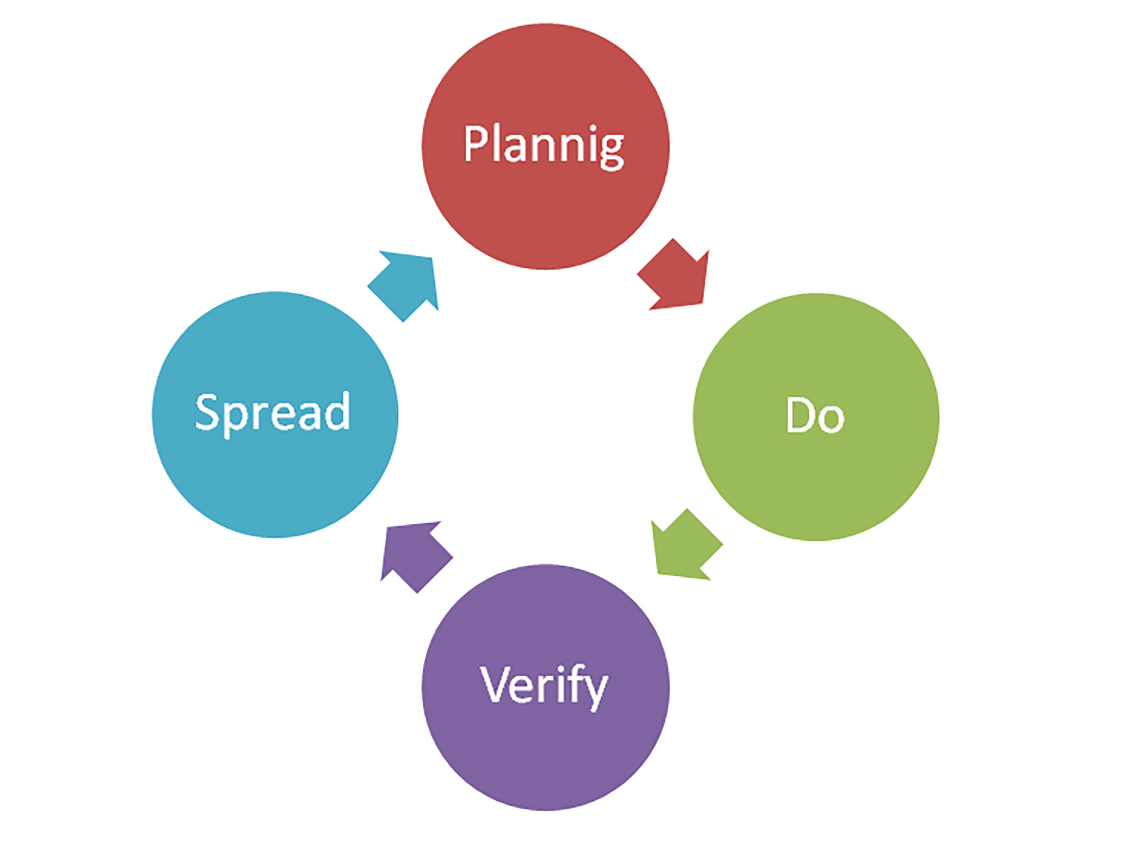
Based on the results of the first phase, the second stage is established. It consists in the development of the application. Here the phases of the PDVS cycle are applied as shown in Figure 1, as an agile and alternative methodology for software development. The methodological basis is established on the proposal of Szalvay 8, whose methodology proposes the development of applications based on iterations or small stages, dividing the execution of the project into blocks, obtaining a reduction in the development time of the project.
The project iterations are described below:
PLANNING is the need you have with the development of the application, at this stage we define the scope of the application in terms of location. The platform to be used for programming the app is defined, and a design is made; in addition to this, the necessary information and the content of the application are consulted.
In the DO iteration, the tangible development of the application is specified in terms of development station and programming language. In this stage the developer looks for the indexes that allow the application statistics to be validated, additionally the databases are linked with the relevant information.
The next iteration is VERIFY, which aims to validate in technological means (Computers, mobile devices with Android operating system and tablets), stability and tests as failures that the app may have.
Finally, at the end of the testing stage, we proceed to start the SPREAD iteration, where the app is spread for interested users, validating the corresponding indices and indicators.
3. Results and Discussions
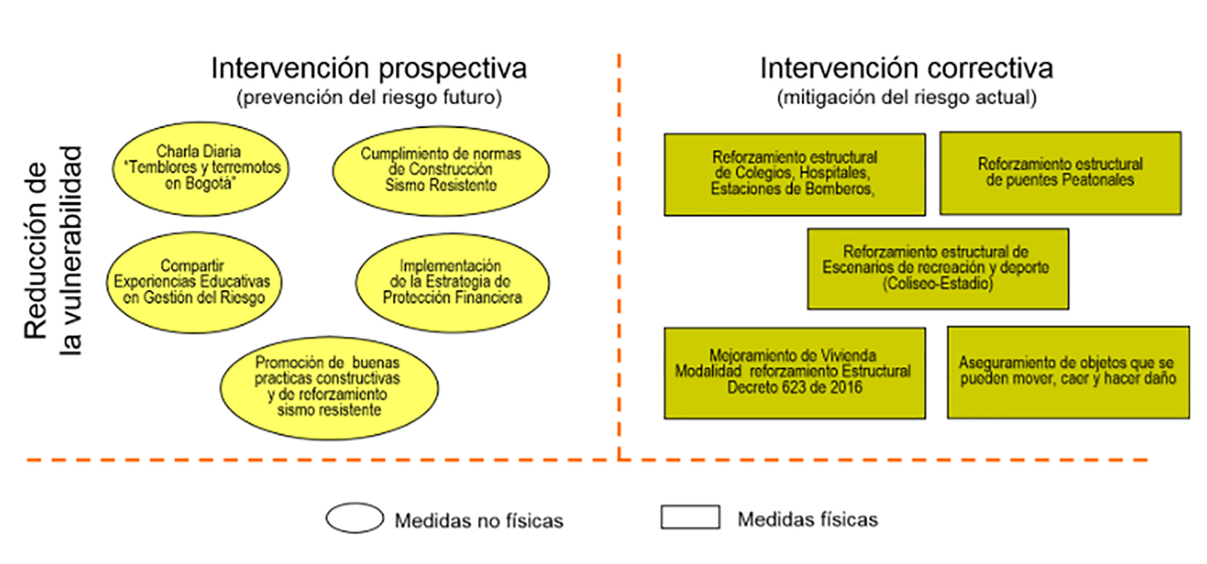
Understanding risk as the main parameter that allows to prevent a disaster, it is desireable to have the necessary tools that allow an adequate response to situations that may endanger the human condition. The government has established Law 523 of 2012 which defines the strategies and the dependencies in charge in cases of disasters, as well as providing the guidelines to react in case of risk situations idenjpgying the factors that affect it.
As shown in Figure 2, it is sought to minimize the human life vulnerability, and as part of it the prospective research in risk prevention is very productive since, in essence, minimizing risk is anticipating and being prepared, in the same way, if a corrective intervention is carried out, as the graphic shows, it seeks the structural reinforcement of the city's facilities.
To generate information about seismic risks, the integration of technological systems is sought, which in this case does not seek to improve company competitiveness, but instead to improve social competitiveness with the objective of generating interest in the community about risk situations. For this reason, it has been shown in the last few years how the Colombian government has promoted the design, development and use of mobile applications to improve the quality of life of people and generate a more globalized environment, which is why ICT is seen as a basic and available tool to everyone that can be use to spread information systematically.
Due to the scope that technology has had and the 4.0 revolution that it is developing, there are different groups that seek to create technologies, or take advantage of technology to save the human condition, based on this, in several parts of the world applications have been developed, which allow mitigating risk and preventing disasters. Such is the case of an application implemented in Japan called Negichizu, whose operation is established with an instrument that digitizes the plans established in a database, on movements, times and evacuation routes “The digital version, which is interactive, allows to evaluate the departure times of the routes determined by the users, it proposes alternative directions and supports urban planners and the authorities in charge of disaster management” (9. This demonstrates that Japan, a country that is constantly at risk of large earthquakes, has developed a vital awareness in risk prevention and mitigating human life with plans and strategies focused on prevention and actions in situations of disarter.
In the same way Indonesia has an application called Quick Disaster which contains lots of disaster information “For example, through the use of real-time location data, those who use it receive a warning when they enter to prone areas to certain types of disasters , and evacuation routes are shown when a disaster occurs” (9. These types of applications are designed to solve the response times and the logistics used in the evacuation routes for people. In Spain they are looking for applied technology for disaster prevention, such activity is evident in the article Design of an Intelligent Computerized System for Seismic Detection and Early Warning with Ethernet Communication and Mobile Technology, its objective is to design a model using mobile phones as servers of seismic detection, and link them to the sensors, in case of a seismic event, it spreads the message to the relevant authorities, which it means that it allows to generate a massive diffusion system in case of disasters 10. Studies of this type will surely give results that allow its use in disaster prevention.
At the Latin American level there are also some applications that seek to give early warnings in disaster prevention, one of them is Disaster Alert. This is an application that allows you to monitor different types of disasters in America, such as fires and floods. Ubalert is another application that allows monitoring any type of disaster, adding a function that makes possible the user to generate reports in case of disasters or emergencies from the same application. In the case of telluric movements there is a specialized application called Terri, this App is worldwide and allows you to observe the different telluric movements that can occur anywhere in the world.
Up to this point, it should be noticed that the review allows idenjpgying elements that must be present in the design of the app, giving information modules to the users about disasters by geographical location, in order to generate prevention awareness.
Proposals are also arose in the academic scenario such as the article “Early Warning System for Earthquakes: An innovative and economic proposal based on Smartphones” whose aim is to link smartphones with the accelerometer system and turn them into a source of information for the user in case of an earthquake alert (11. Proposals of this type seek to make use of technology by creating new needs focused on preventing risks.
At the local level we also have different applications that allow us to support the disaster prevention system, one of them is called Yo Reporto which allows us to nojpgy any type of natural phenomenon that can be life-threatening, and this information is consolidated into databases for strengthening the disaster information systems. There is also the application called ABC Gestion de Riesgos which is an application designed so that the user knows how to act and prevent risk situations caused by natural disasters.
In the article “Collaborative environments: A new way of managing risk” an application for risk awareness in the Guavio region, called “Guavio Alerta”, was developed in order to obtain information related to the risk of disasters from the collaboration of the community, and automatize the information channels through information is entered 9.
Another of the technological initiatives that seeks to contribute to reduce risks are mobile applications that allow reducing the vulnerability of structures, in an article published in 2018 called “Application of ICT in the Analysis and Perception of the Vulnerability Level in Residential Buildings in he city of Cucuta ”the objective is to use an application that allows the user to use it to know the vulnerability level in the buildings by choosing the sector in the city of Cucuta, and also to help build a plan to reduce the seismic vulnerability (12. This idea has taken shape not only in Colombia but also in other countries such as the US, where they have conducted studies to minimize the impact of buildings, as in the article “The app acts as a sensor to collect urban data, such as structural acceleration, structural deformation, questionnaires, and images, and implements disaster emergency communications without the use of a network” 13.
This type of monitoring helps to reinforce buildings and prevent future disasters. In addition there is an app that uses augmented reality to generate a catastrophic event, and thus be able to find the best ways to react in that situation, in summary in “Any situation necessitating rapid medical attention (eg road accident, heart attack…) and occurring during this period of time could have ended dramatically (14.
In general there are studies that seek to measure the impact of mobile apps, as in the article “This review further focuses on the built-for-disaster-purpose apps and shows the various interactions these apps foster with the public and the apps 'value-added contributions” 15, This type of study seeks to integrate the present needs for future applications. In the US they have come to think of generating applications that generate revenue, as in the article “almost two-thirds report being willing to pay something for an Earthquake Early Alert app on [their] smartphone or personal computer”. Median willingness to pay per month is $ 1. Perceived risk” 16. By increasing the perception of risk, people would be willing to pay a value for a system that allows them to be prepared for any catastrophic earthquake event. Speaking at a technological level, some articles that have been presented seek to convert smartphones into accelerometers that allow measuring the magnitude of telluric movements to generate early risk alerts “It shows the differences between professional accelerometers and smartphone sensors, demonstrates the vibration measurement and evaluation capabilities using Dynamics” (17. However, there are also more complex solutions such as in a study carried out by the European Center of Seismology that develops through different ways such as social networks, the use of the eyewitness from events that include telluric movements in order to collect indirect information to be analyzed and processed in earthquake prevention “We argue that this simple and affordable system, based on standard Internet technologies and social media, can reduce anxiety by offering timely information and services to eyewitnesses and possibly contribute to immediate global seismic risk” 14. Social networks also contribute to risk mitigation, in the 2015 earthquake in Nepal and India it was evident the need to cover several aspects that were not taken into account in the attention of the earthquake, for this reason the article “This work has been carried out in association with Doctors For You (DFY), a humanitarian organization of medical professionals who work in various disasters-affected regions” 18, shows how instant messaging-based collaboration contributed to the analysis of“ A large set of WhatsApp messages exchanged among DFY members who were working in the disaster-affected areas of Nepal was collected and analyzed to idenjpgy the different resource requirements and the corresponding delay in the mobilization of such resources” 19. This information will allow worldwide protocols for disaster relief.
Finally, the systematic review of the applications carried out in this article allows us to idenjpgy that the protocols that the authorities have for disaster prevention, constitute another essential module.
So far the project develops its first phase, which allows us to propose the development of the mobile application called BOGSAT (Early Warning System). This app generates information systems in an integrated way in one place for the community, including emergency numbers, general recommendations and emergency protocols.
The results of the second phase implementation are described below.
3.1. Plannig
The application is limited to the city of Bogotá; therefore, the creation needs for the app focus on the following criteria:
3.2. Do
3.2.1. Hardware Resources
Firstly, it is essential to idenjpgy the mobile application hosting, therefore, the alternatives are oriented to use the cloud, or to have a conventional server.
In this sense, the cloud hosting, thanks to its great potential for scalability and performance, offers more capacity than classic hosting. One of the benefits is related to operational efficiency that can be increased several times. In addition, there is the possibility of obtaining reduced costs or implementing an open source web hosting solution at zero cost. In the first case, it increases reliability, security, and scalability; in the second case, it is possible to have the app accompanied by embedded advertising. Hardware maintenance problems, failures, or resource limitations are minimized in the option with payment. Virtually, unlimited things can be achieved due to the power of cloud computing.
Economically it is much better to host a development applications in the cloud environment because it uses sophisticated security measures that ensure good data protection and the resources can be updated at any time.
Despite the benefits mentioned, the first version of the application was implemented in the AppCreator24 cloud service. Table 1 describes the characteristics of this hosting.
Table 1 AppCreator24 Description
| Service | Characteristics |
|---|---|
| AppCreator24 | It allows you to create a native application for free, easily and without programming knowledge. |
| The application is scalable to Google Play. | |
| Allows communication with users immediately. | |
| Facilitates access to statistics on facilities and usability. | |
| Implements HTML5 programming language. | |
| The changes in the application are reflected in the users' devices immediately. |
3.2.2. Development stage
In Table 2, it is evident that the development of the application is carried out with some requirements in the development stage, since it is the one that allows interacting with the server and programming the application
Table 2 Development stage
| Data | Value |
|---|---|
| Ram | 8Gb |
| Processor | Core i5 fourth generation 2,2 GHZ |
| Storage Capacity | 1 TB |
| Others | Graphic Card Nvidia GeForce 820M |
In Figure 3, it is shown how after planning the design, it goes into execution under HTML5 language.
3.3. Verify
Based on the information obtained through the systematic review for the choice of modules, in the verification phase once the programming has been carried out, the way in which the application is executed is reviewed and the operation of the application modules is verified. Table 3 shows the different components that the application brings to develop an interface that allows the people to navigate the app.
Table 3 Fundamental components
| Module | Description |
|---|---|
| General Information | Brings general information about the seismological movements in Bogota. |
| UNGRD | This module connects to the national disaster risk management web page. |
| Key Concepts | This module provides information about action protocols in case of an earthquake emergency. |
| General Recommendations | This module brings information about disaster prevention due to seismological risk. |
| Emergency Contact Numbers | This module brings information about the main entities emergency contact numbers. |
In Figure 4, the distribution of the six navigation menus of the app is shown.
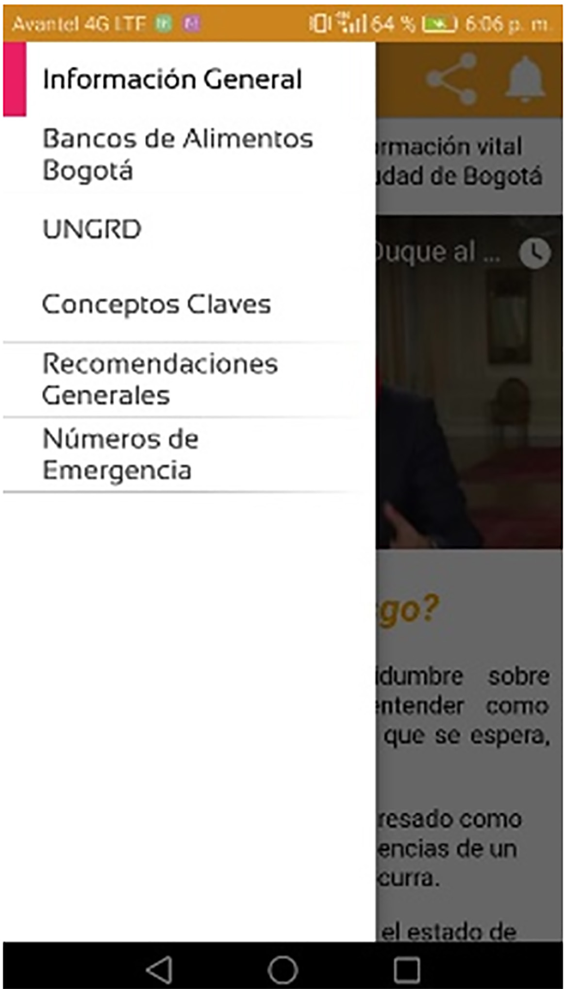
Figure 5 shows the UNGRD module, which has a direct link to the national unit for risk and disaster management web page. Likewise, in the general information module, in Figure 6, it is possible to obtain relevant information about how to act in a moment of telluric movement.
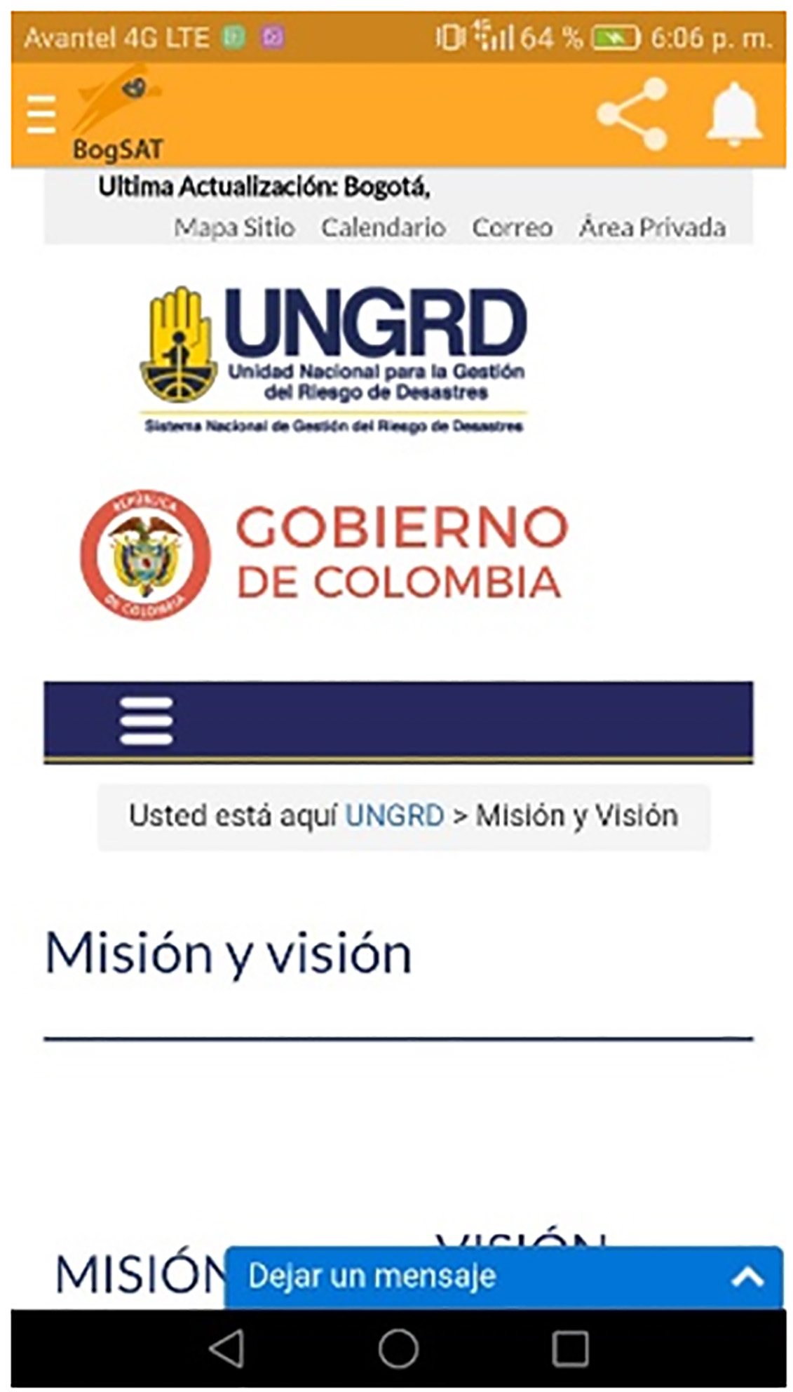
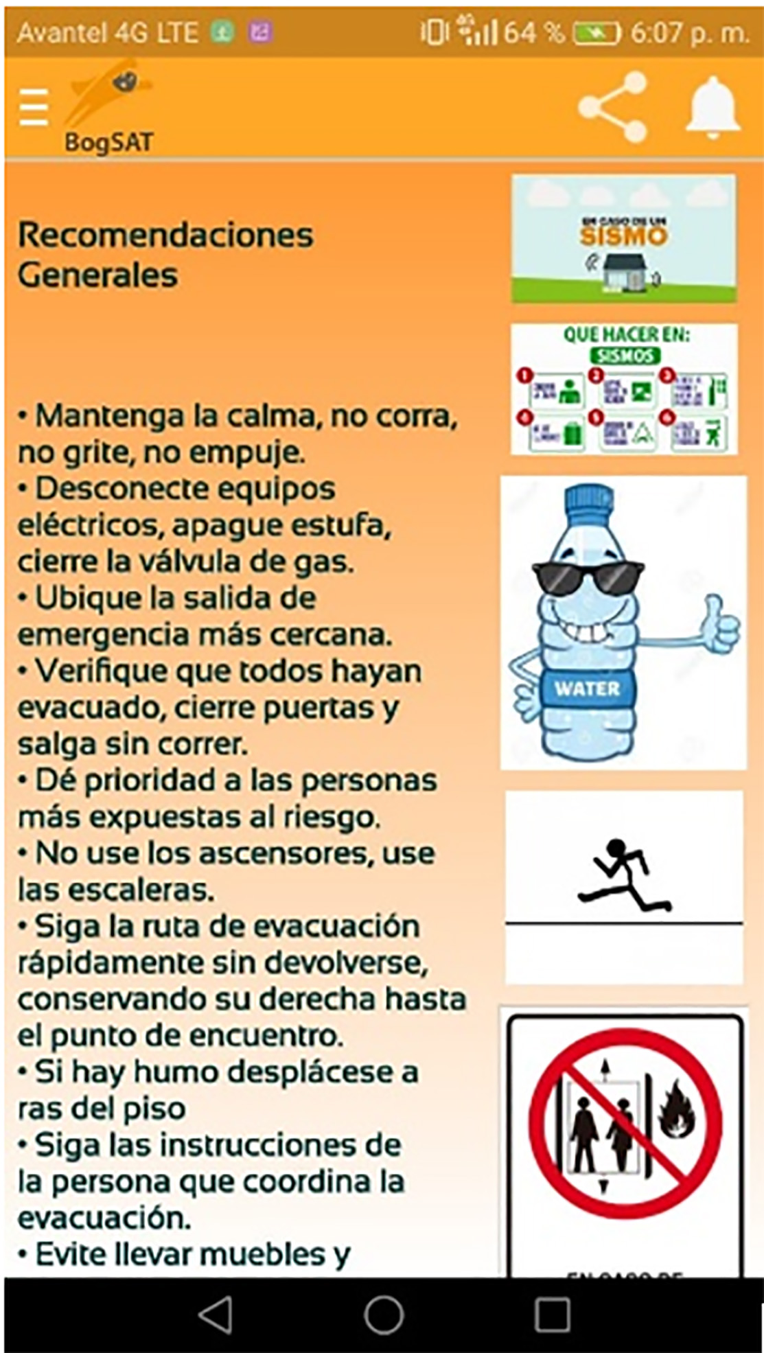
Figure 7 shows the general recommendations such as the evacuation, prevention and attention of a disaster caused by an earthquake protocols provided by the national and district authorities. Likewise, in Figure 8 it is possible to obtain an image of the food bank location provided in Bogota.
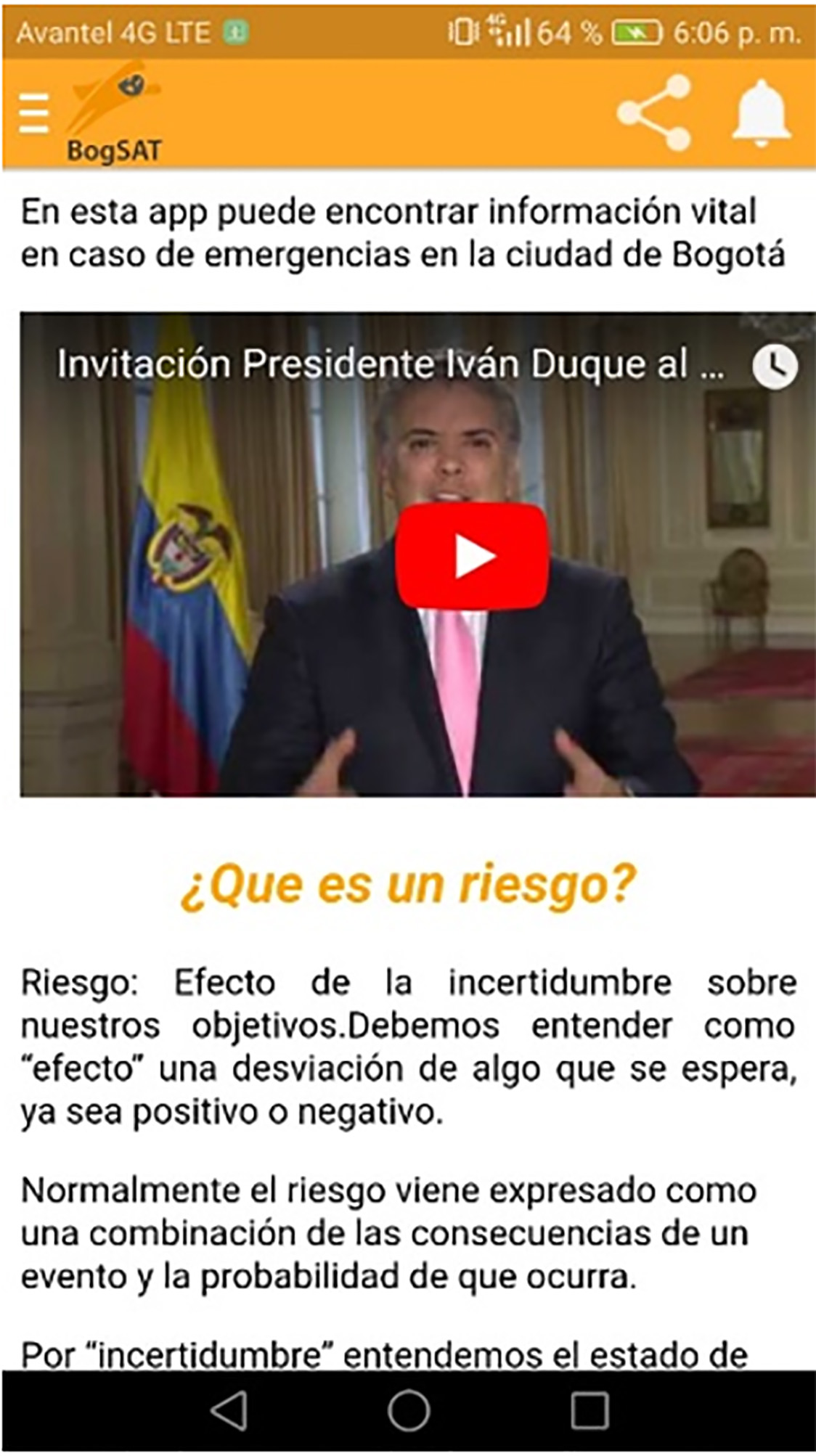
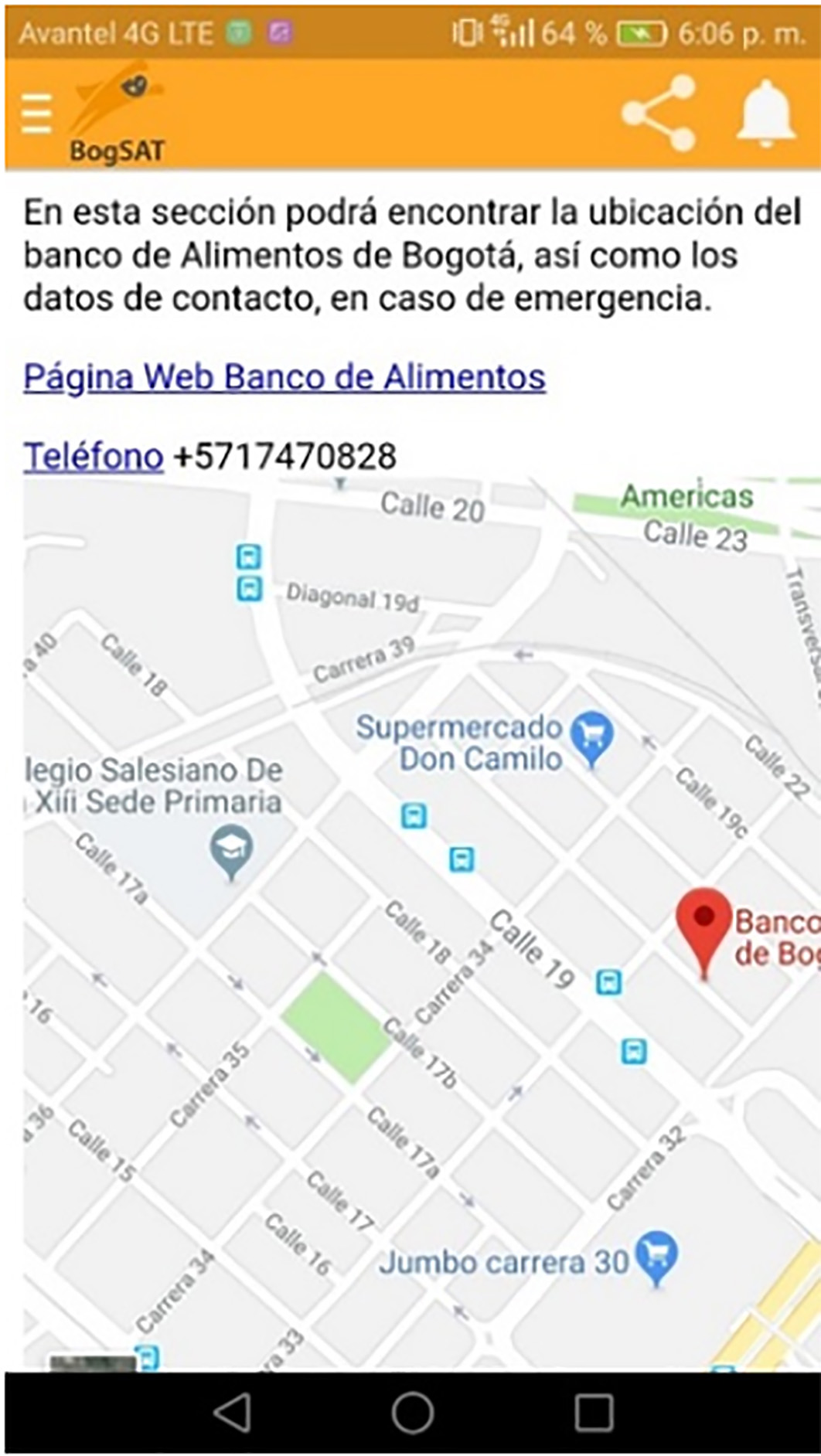
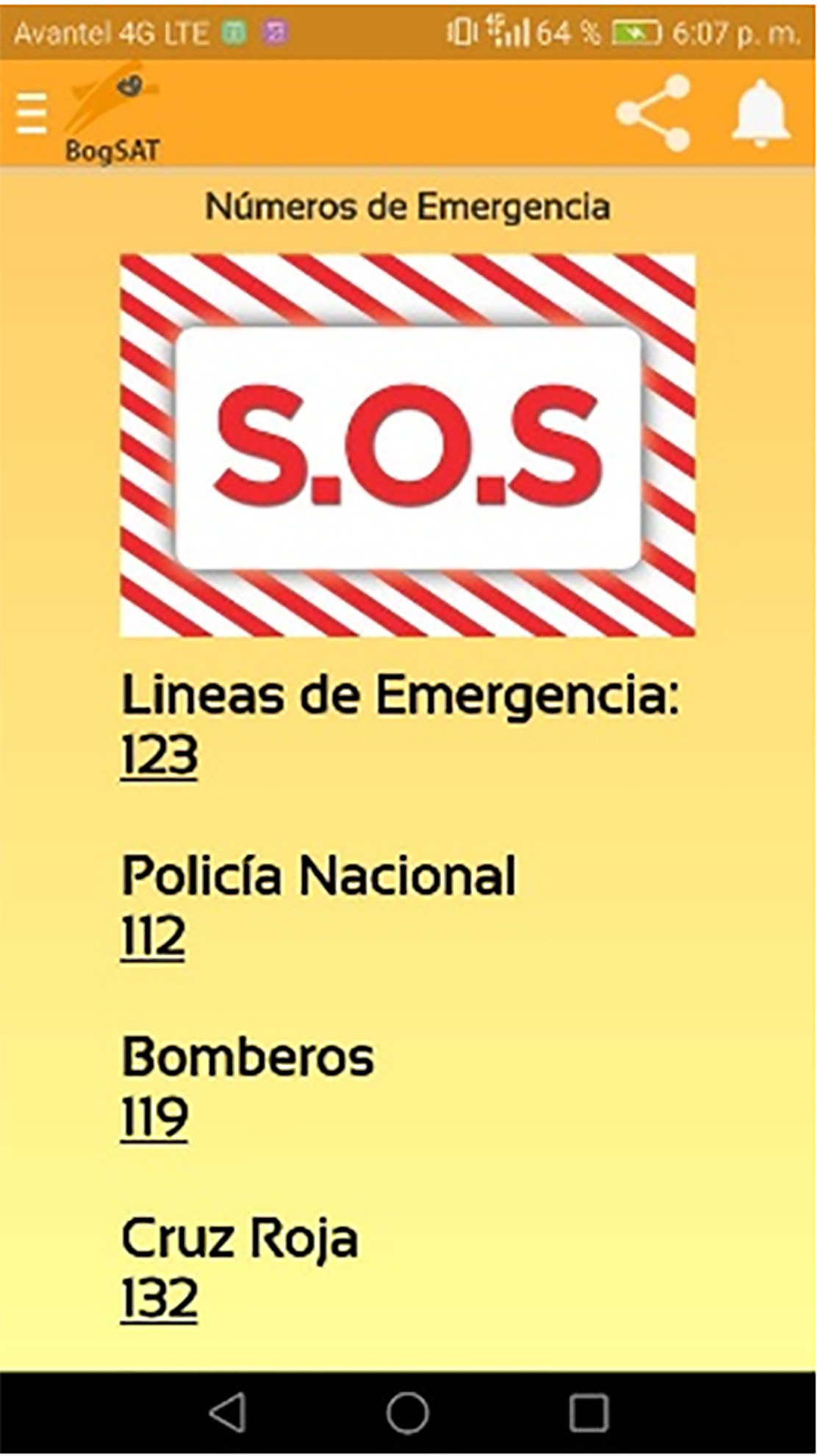
Figure 9 shows the section that allows us to have the emergency numbers of the responsible authorities in charge of dealing with disasters caused by an earthquake.
3.4. Spread
It is done through the QR code in Figure 10 so that any user can download it.

Going to the app validation, it is pertinent to indicate that the normative context refers to using the ISO / IEC 9126 standard to measure the usability. However, Yanken 19 refers to “the ISO / IEC 9126 standard, which, when measuring usability in mobile educational applications, is not as complete, since it does not take into account the characteristics of this type of application,” which makes that the success of the application is measured more by satisfaction indicators, for example the rating given with stars to an application on Google Play.
The results and the success of the application design is validated through an indicator that tells us if the users are using the application, for this the Eq (1) is implemented.
The estimate provided by Eq. (1) leads to determine the usability index in the aplication, where the results will depend on the number of users who download the application in a period of time.
However, the usability and satisfaction that the user may have with the application is given by variables such as, a) the quality represented by the environment, b) connectivity with other applications, c) the ability to process the information, d) time needed to respond to a task, e) time to connect to a network, f) battery used, and g) if it can be used online and offline. But beyond this, usability seeks the user to use the application in a specific context.
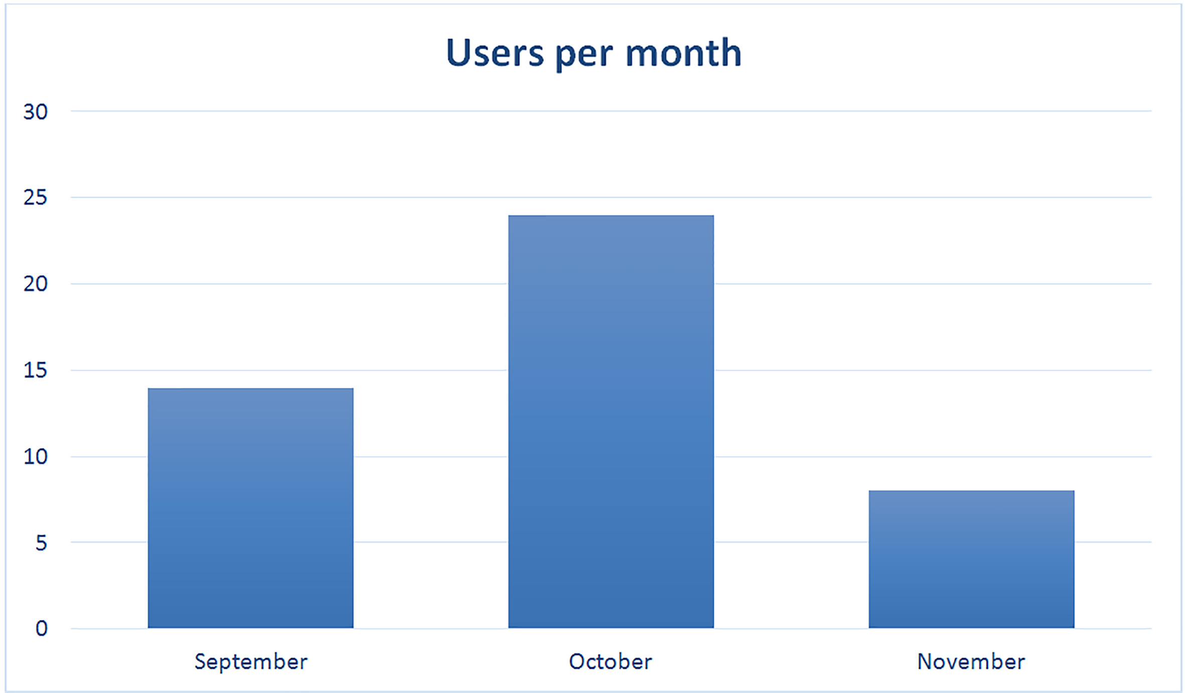
To begin to characterize usability, the user registration per month was obtained, with a total of 46. From this point of view, Figure 11 allows us to idenjpgy that in the period of time covered by three months, October was the month that presented more users.
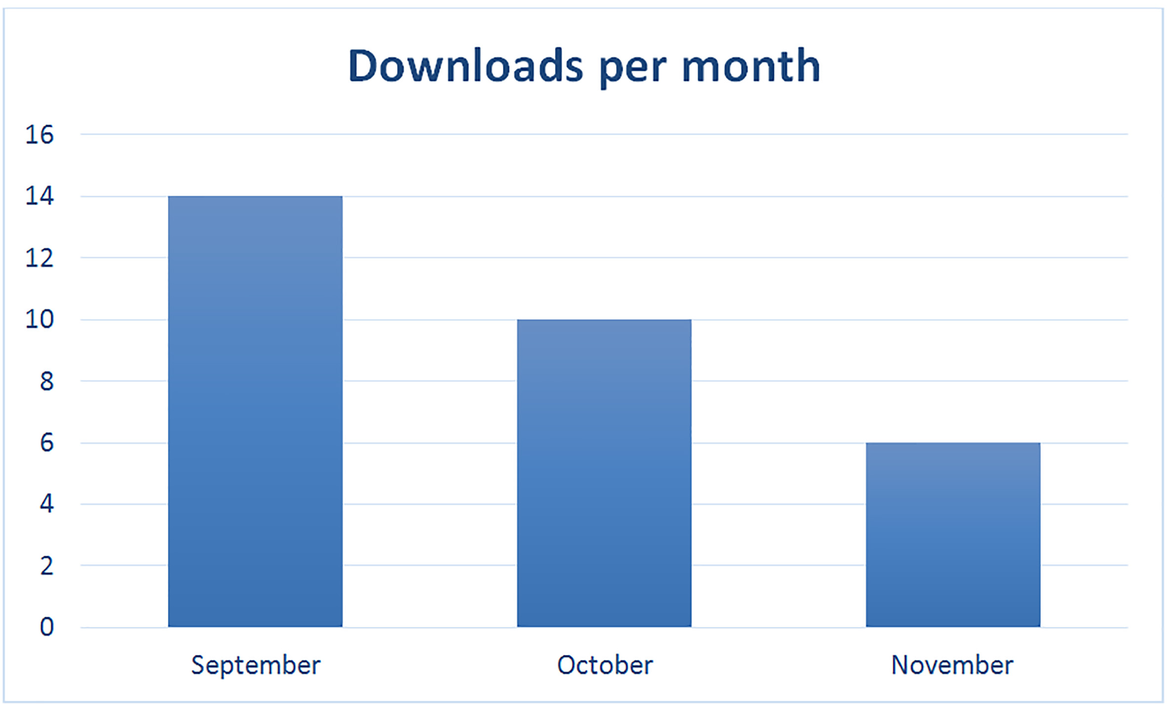
Next, the record of downloads per month is presented in Figure 12, where it is pertinent to note that there are conceptual differences between user registrations per month and downloads per month. In this sense, the registration of users per month is obtained through interaction with the app, that is, the association of the user account of the mobile device with the application, and the download indicator only allows to infer that the application has been downloaded of the hosting site.
Based on the above, the registration indicator allows idenjpgying that the sum of the installations of September (14) plus the installations of October (10), correspond to the 24 users of October.
4. Conclusions
The use of technology in recent years has had a relevant impact when we talk about generating information concerning the vulnerability of human life, if we use collaborative environments along with technology, we will prevail the fragility of human life in situations of risk. In the matter of prevention, Bogota has plans that mitigate the risk to the community, however, it is necessary that the citizens have more commitment to mitigate the risks that may exist in case of catastrophe.
For this reason, mobile applications are instruments that help to spread relevant information about risk prevention, but it has limitations such as the number of users who download the application and give it the use for which it is formulated, however the study shows several worldwide resources that are constantly developing innovations in disaster prevention and that can help to develop standards in earthquake disaster prevention and care.
Although there are applications in Colombia that are designed to report incidents and have information about risk situations, it is evident that there is a lack of consolidation of relevant information database such as meeting points, areas of greatest risk, structures that need reinforcement, which makes this application an excellent opportunity for technology and collaborative environments to come together and throughout the application be a reference in disaster prevention.
The App also needs to develop more visual environments since it is not interactive, users are prone to do not have mastery when running it.
Finally, it should be noted that the research provides scienjpgic references to jusjpgy the incorporation of an app for disaster prevention purposes in each Colombian city, where in addition to minimize the
For future development researches, the following lines are proposed: study of applications with information in Augmented Reality and expand the deployment of the app through academic and government scenarios.

