


 Inglês (pdf)
 Artigo em XML
 Referências do artigo
 Enviar este artigo por email
 Citado por SciELO
  Citado por Google
  Similares em
SciELO
Similares em
SciELO  Similares em Google
 Permalink
1. Introduction
In Colombia, the Riparian Buffer Zone is defined as the minimum space on both margins of a main channel where hydrological, geomorfological and ecosystem dynamics can be developed, as well as socio-cultural and economic activities that do not constitute any risk for the natural function of a river, nor for the life and goods of communities 1.
The regulations in Colombia since 1977 (Decree 1449) 2 have restricted land use to a minimum width of 30 meters on each margin of the main channel, with the aim of protecting natural resources. However, the extent of these protection strips cannot be established in a general sense for all rivers since each channel has its own conditions related to its natural behavior and dynamics, and the socio-economic activities that are developed on its plain.
In Colombia, only the departments of Cundinamarca, Risaralda and Caldas have established laws and criteria to delimit riparian buffer zones, but without directly considering aspects of great relevance such as the geomorphology of channels, among others.
In the case of the Cauca River on its way through the department of Valle del Cauca, its regional environmental authorithy (CVC) in 1979, through the Agreement 023 3, established general norms to locate riverside dikes of public water domain. This norm was adjusted and updated in 2011 through the Agreement 052 4.
However, these legal measures are not fulfilled along many sections of the Cauca River. The development of intensive agricultural activities on its floodplain has led to the construction of numerous marginal dikes located close to the main channel and the channels of its tributaries, without respecting minimum distances; in order to increase the arable area to obtain "greater economic benefits" (5. Nevertheless, the dikes located close to channels generate an increase in water levels, causing downstream overflows, floods in unprotected sectors and large economic losses. Likewise, the development of socio-economic activities on these areas close to the channels has caused an appreciable reduction of native vegetation, which supports many plant and animal species.
The floods that occurred during the rainy season of 2010-2011 caused serious damage and impacts on different productive sectors and in riverside populations of the Cauca River in the department of Valle del Cauca; affecting 173,002 people and 35,961 families, destroying 76 homes, and damaging 29,655 homes, which caused economic losses up to 963,747 million pesos (6.
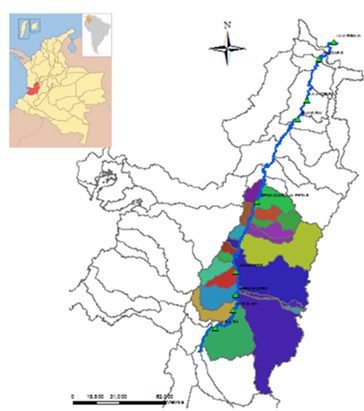
This issue revealed the urgency to carry out an analysis towards the integral management of flood risk. As part of this objective, this study delimited the riparian buffer zone of the Cauca River along the section between two hydrometric stations: La Balsa, located in the municipality of Buenos Aires, Department of Cauca, and Mediacanoa, located in the municipality of Guadalajara de Buga, Department of Valle del Cauca, Colombia. The methodology proposed and implemented here can be replicated in other sections of the Cauca River and in other alluvial rivers, since the study area represents the general conditions of the river with respect to its river dynamics and the current use of the floodplain.
2. Methodology
2.1 Characterization of the study area
The delimitation of the riparian buffer zone was carried out for the section of the Cauca River located between La Balsa district in the municipality of Buenos Aires, department of Cauca, and Laguna de Sonso in the municipality of Buga, department of Valle del Cauca (Figure 1). The flow regime of the Cauca River is conditioned by the operation of the Salvajina dam that began operation in 1985 and along the study section by the contribution of 23 rivers.
From the Salvajina dam to the municipality of La Virginia, the Cauca River comprises of an alluvial channel and existing areas on its plain that favor the exchange among biotic and abiotic components of an ecosystem, such as wetlands, protected natural areas, forest cover and fragments of areas that could allow connectivity through ecosystems.
These areas have been intervened by different socio-economic activities, generating a great environmental impact and deficit in natural resources due to their high demand, causing the loss of biodiversity and the increase in flooding.
2.2 Methodologies for the delimitation of the riparian buffer zone
The delimitation of the riparian buffer zone of rivers can be established considering fixed or variable distances that are determined from their hydrological, geomorphological and ecosystem conditions. In Spain and Colombia, the socioeconomic aspects related to the populations surrounding the rivers are also considered. In The Netherlands, it is proposed to evaluate, via hydrodynamic modeling, the decrease in water levels by increasing the extent of the plain with respect to current use.
In general, the methodologies that consider the analysis of hydrological behavior indicate that for the delimitation of the room for rivers, the envelope of the flood polygon must be determined for a given return period.
The following methodologies are followed in Spain (i) Public Hydraulic Domain, which considers a 10-year return period flood to establish the channel, plus a distance of 100 m on each side of the flood polygon; (ii) High Volume Drainage Channel, which considers the envelope for a return period of 100 years and the possibility of reducing this area by evaluating the increase in water levels 7; and (iii) Sustainable Fluvial Territory, which although it mainly considers geomorphological, ecosystem and human constraints aspects, establishes that the flood area could be included or not for a return period of 5 years for large channels and 10 years for small ones 8.
In Mexico, in accordance with the Article 3, section XLVII of the National Waters Act of 1992 9, a flood with a return period of 10 years for channels with widths less than 5 meters is considered for the delimitation of room for the river.
In Colombia, the delimitation of the hydrological component, proposed by the MADS, indicates a return period of 15 years for non-intervened channels and 100 years for intervened ones, as is the case of the Cauca River 1. According to the Autonomous Corporation of Cundinamarca 10, the room for the rivers under its jurisdiction is also delimited considering a 15-year flood, without deferring if the channel is intervened or not. The Regional Autonomous Corporations of the departments of Risaralda and Caldas, through Agreement 028 of 2011 11 and Resolutions 053 of 2011 12 and 561 of 2012 13, respectively, establish a 15-year flood to define the permanent channel. Additionally, the department of Risaralda establishes for the delimitation of wetland’s riparian buffer zones an increase of 10 years plus a strip of 30 m. The department of Caldas for channels with slopes below 12% an increase of 100 years and in channels with torrential flows or slopes greater than 12% should be considered a 100-year flood plus 40% of the flow.
For the analysis of the geomorphological behavior, the methodologies analyzed have fewer differences; in general terms, the envelope of old channels is considered. Additionally, in Chile it is proposed to include slopes greater than 30% 14. In Colombia, MADS proposes to consider geomorphological units, and in the department of Caldas the geological threat is considered.
The areas where there is natural vegetation should also be considered for the analysis of the ecosystem behavior of a channel since these areas allow the movement of wildlife. In Spain, it is proposed to include areas with natural vegetation in the delimitation. The methodology proposed by the Environmental Authority of Cundinamarca in Colombia establishes that this delimitation depends on the average canopy height of trees.
In cases where natural conditions have been transformed and there is no natural vegetation, the delimitation of the riparian buffer zone is quite complex; MADS proposes a distance from the average canopy height of dominant trees located in other areas with hydrological and geomorphological similarity and the relationship between drainage density and the area of the afferent basin. The department of Caldas proposes a distance equal to the width of the channel on each side.
2.3 Analysis of the available methodologies for the delimitation of the riparian buffer zone with respect to the characteristics of the Cauca River
In general, the methodologies identified to delimit the riparian buffer zone of rivers coincide in taking into account the hydrological and hydrodynamic characteristics. Nevertheless, the proposed return periods vary between 5 and 100 years.
The methodologies proposed in Colombia for intervened channels and in Spain under the denomination of “High Volume Drainage Channel” consider a return period of greater magnitude associated with a recurrence of 100 years. Nevertheless, in Spain in recent years, using the methodology called “Sustainable Fluvial Territory” it is established that the room for the river must mainly consider the ecosystem and geomorphological characteristics. Besides, the flooded area for a return period could be included or not, taking into account that for large channels the analysis must be for 5 years with a return period and for small channels a 10-year return period flood.
Considering the high sinuosity of the Cauca River, which demonstrates the mobility that the river has had over time, the delimitation of the riparian buffer zone must be established considering a variable width, defined primarily from the geomorphological characteristics, despite the fact that the plain of the river has been intervened, since river geomorphology constitutes the footprint where the river has historically moved.
According to Soto 15, who established that the maximum return period of the bank-full flow between La Balsa and Mediacanoa stations is 5 years, for the delimitation of the riparian buffer zone this return period was considered as well as the return periods of 15 and 100 years, as suggested by the MADS. Nonetheless, in a study conducted by the Universidad del Valle and the CVC 16, when transiting the 15-year flood, a correspondingly large flood area was obtained to 53,999 ha from Salvajina to Mediacanoa.
Additionally, the Cauca River plain has been intervened with socio-economic activities that conflict with the natural dynamics of the river. Therefore, establishing a delimitation of the riparian buffer zone ignoring the current situation would be a proposal with a low probability of execution, since the success of environmental projects lies largely in the acceptance of the different stakeholders without ignoring the natural conditions of the river.
Regarding the analysis of the ecosystem characteristics of the Cauca River, areas of recognized environmental importance, such as wetlands (Laguna de Sonso), protected natural areas, conservation nuclei identified by the CVC, which correspond to sites with conservation opportunities, such as forest fragments that contribute to conserving biodiversity and allow connectivity between ecosystems and protective forest areas.
Therefore, a combination of methodologies implemented in Spain (Sustainable Fluvial Territory), The Netherlands, and Colombia (proposed by the MADS) was used to delimit the riparian buffer zone of the Cauca River along the section between La Balsa and Mediacanoa. The methodology proposed by the MADS was the most structured with respect to the ecosystem and geomorphological conditions.
Two alternatives were established to delimit the riparian buffer zone of the Cauca River: (i) the area established from the ecosystem characteristics and the stipulations of the CVC’s Agreement 052 of 2011 4, and (ii) the area established from the ecosystem and geomorphological characteristics. Additionally, the variation of water level and velocity was evaluated with the hydrodynamic model SOBEK 1D and 2D, considering the floods with return periods of 5, 15 and 100 years without protection works. Finally, the delimitation of the riparian buffer zone of the Cauca River was established between La Balsa and Mediacanoa stations.
2.4 Delimitation of the permanent channel
Taking into account that the permanent channel of a river is the visible scar of the land, the channel was delimited along the study section from the contour lines with detail of 30 cm, and the elaboration of a shadow model of the Cauca River. This allowed visualizing the depth of the land surface using the ArcGIS 10.6 program. The contour lines were supplied by the CVC and are the result of the combination of the topobatrimetric survey carried out in 2012 17 with light and distance detection technology called LIDAR. This technology takes its acronym from English (Light Detection and Ranging or Laser Imaging Detection and Ranging) and the bathymetry of the Cauca River carried out in 2013 18.
2.5 Delimitation of the geomorphological component
The geomorphological component is associated with the morphodynamic geoforms and processes of the water and sediment cycle. Therefore, this component was defined from spatial variability at different time scales, where morphodynamic processes are presented in which the system adjusts the shape of the channel, its slope and its alignment patterns 1. Thus, for the delimitation of the geomorphological component of the Cauca river, the geomorphological subunits were considered, which represent the processes of erosion and deposition of sediments of the river, and the different channels of the Cauca river in 1957, 1966, 1977, 1998, 2007, and 2012 available at the CVC.
2.6 Delimitation of the ecosystem component
As proposed by the MADS, this component must be defined from the drainage density for each geomorphological unit at a regional scale, that is, 1: 25,000. Even so, Carvajal 19 in 2011 establishes that there is no standardization of geomorphological cartography in Colombia, since several methodologies with different categorizations are used, therefore, geomorphological units at 1: 25,000 scale do not necessarily correspond to a regional scale.
Therefore, a documentary research was carried out about the geomorphological categorization established for the department of Valle del Cauca. This research found that there was a classification based on Landscape Units called Drainage Basin or Mountain Zone, Hill Area, Fan Zones and Alluvial Plains of the Cauca River, and a classification by morphological subunits of the Cauca River Alluvial Plain, which depend on the erosionable and depositional processes of the Cauca River and Lithological Controls. Considering that the classification by landscape unit corresponds to a regional scale, it was decided to use the classification proposed on the book “The Cauca River along its High Valley” of the Universidad del Valle 20.
Taking into account that the Cauca River is located inside the geomorphological unit called the Cauca River Alluvial Plain, the drainage density (1.15 km / km²) was established in this unit as the ratio of the drainage length to scale 1: 25,000 (918 km) and the total area of the Alluvial Plain (800 km2). Subsequently, the relationship between the density of drainage and the area of drainage per geomorphological unit (N) was determined, as proposed by the MADS.
Likewise, a review of the book "Forest Species of the Cauca Valley" 21 was carried out and seven species were found that existed along the Cauca River Alluvial Plain, and can reach heights between 15 and 40 m. For the purposes of the delimitation of the riparian buffer zone, an average canopy height of trees (H) of 20 m was adopted. Finally, based on the average canopy height of the trees and the drainage density per geomorphological unit, the relationship of these two variables was found, in accordance with the proposal of the MADS, finding that the delimitation of the ecosystem component is 70 m from the main channel.
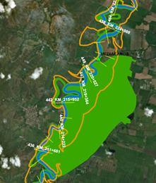
Within the scope of the project “Cauca River Corridor” 22, carried out by the CVC between 2012 and 2014, seven conservation spots were identified along the study section that will allow the connectivity of the ecosystems: The Protected Natural Area of the Integrated Management District of Laguna de Sonso, which has great importance for the conservation of biodiversity in the Cauca Valley; the wetlands recognized by the Agreement 038 of 2007 of the CVC 23, the Agreement 006 of 2010 of the CRC 24, those declared as areas of international importance RAMSAR by Decree 251 of 2017 25 and those identified from aerial photographs. These areas were established as an ecosystem component, plus 70 m at both margins of the main channel of the Cauca River. Figure 2 shows the delimitation for the Lagua de Sonso sector.
2.7 Delimitation of the hydrological component considering floods with return periods of 5, 15 and 100 years
The Cauca River Model was used to determine the hydrological component, which is schematized in the Sobek 1D / 2D combined hydrodynamic model. For this purpose, the calibration of the one-dimensional model and the schematization of the two-dimensional model were adjusted. In the adjustment of the two-dimensional model, the protection dikes from the DTM were removed from the editing of the contour lines, which are at a detail scale of 30 cm.
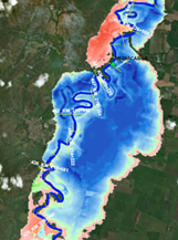
Subsequently, the floods associated with the return periods of 5, 15 and 100 years were transited, and flood maps were obtained for the hydrological component of the riparian buffer zone of the Cauca River along the study section, obtaining areas of 15,245 Ha, 19,848 Ha and 25,240 Ha, respectively, equivalent to 51%, 66%, and 85% of the alluvial plain of the Cauca River. Figure 3 shows the delimitation obtained for the Laguna de Sonso sector.
2.8 Hydrodynamic evaluation of different alternatives for the delimitation of the riparian buffer zone
The delimitation of the riparian buffer zone, as proposed by the MADS, corresponds to the envelope of the geomorphological, ecosystem and hydrological components. In the case of the Cauca River, the hydrological component corresponds to 85% of the alluvial plain of the Cauca River. Therefore, it includes in its delimitation the geomorphological and ecosystem components; the resulting area can be reduced in accordance with this same methodology considering the concepts called "Preferential Flow Zone" and "Dangerous Flood Zone" for a 100-year return period flood.
The “Preferential Flow Zone” corresponds to the area of least extension with respect to the delimited area without protection works on the plain, which must ensure that water levels only increase up to 0.30 m and the water velocity up to 10%. The “Dangerous Flood Zone” corresponds to zones of the flooded area without protection works where any of the following criteria are met: (i) the water depth is greater than or equal to 0.5 m, (ii) the water velocity is greater or equal to 0.5 m / s, and (iii) the product of these two variables is greater than or equal to 0.5 m2/s.
In order to know if the “Preferential Flow Zone” criteria are met, the increase in water levels and speed was evaluated considering two proposals for the delimitation of the Cauca River riparian buffer zone on the study section: (i) the first proposal considers what is established by the Agreement 52 of 2011 (by which general rules are issued regarding the location of riverbank dikes of public water domain) and the ecosystem component, and (ii) the second is established based on the geomorphological and ecosystem components. This analysis was performed for a 100-year return period flood as suggested by the MADS for intervened channels, as is the case of the Cauca River, and the floods with return periods of 5 and 15 years were also analyzed for the first proposal, since on the study “An approach to the conditions that explain the fluviomorphological dynamics of the Cauca River along its High Valley” 7, it was identified that the return period associated with the bank-full flow level on the Cauca River for the section of the study varies between 2 and 5 years and the increase proposed by the MADS to determine the riparian buffer zone of non-intervened channels is 15 years.
3. Results and discussion
It was identified that for the first proposal along the section between the Timba River, located upstream from La Balsa hydrometric station, until the South Interceptor channel, the variation in levels is very low for the three return periods. However, for a 100-year return period flood the variation is 0.36 m. In this section, the initial proposal for the delimitation of the riparian buffer zone of the Cauca River is similar to that established considering only the hydrological component (Figure 4). From the South Interceptor Channel the variation of levels increases until reaching 1.27 m, 0.73 m and 0.36 m for the return periods of 100, 15 and 5 years respectively, since along this section the delimitation of the hydrological component is greater with respect to the proposed alternative, due to the existence of the flood protection dike for the city of Cali (Figure 5).
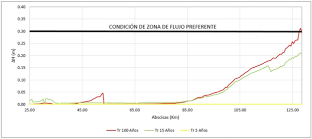
Figure 4 Variation of the water level between the delimitation of the flooded area without protection dikes and the delimitation considering proposal 1 (Agreement 052 of 2011 and the ecosystem component) Section Timba River - South Interceptor Channel.
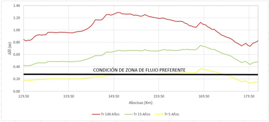
Figure 5 Variation of water level between the delimitation of the flooded area without protection dikes and the delimitation considering the Agreement 052 of 2011 and the ecosystem component. South Interceptor Channel - Amaime River.
From the Amaime River, the variation of the water level decreases considerably, although the initial proposal for a riparian buffer zone is less than the flooded area for a return period of 100 years. The ecosystem Laguna de Sonso lies in this section, and regulates the water levels of the Cauca River. From the abscissa K200 + 000 the water levels increase, since downstream of the Laguna de Sonso the proposed riparian buffer zone is inferior to the flooded area for the 100-year return period flood without protection works. The maximum variation of levels in this section is 0.73 m, 0.45 m and 0.29 m for the return periods of 100, 15 and 5 years, respectively (Figure 6).
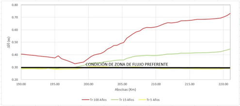
Figure 6 Variation of the water level between the delimitation of the flooded area without protection dikes and the delimitation considering the Agreement 052 of 2011 and the ecosystem component Amaime River - Guadalajara River.
In general terms, along the study section, proposal 1 (Agreement 052 of 2011 of the CVC 4 + Ecosystem component) for the floods analyzed does not meet the Preferential Flow Zone criteria because the increase in water levels is greater than 0.30 m. However, for the 5-year return period, there was only a slight increase of 0.36 m along the section between the South Interceptor Channel and the Amaime River.
When observing the behavior of the speed of water, for the 100-year return period flood, on the plain of the Cauca River along the study section, it was found that the speed increase is less than 0.5 m/s. Yet, when analyzing the water depth, it was found that the area established under the criterion of a dangerous zone would correspond to 84% of the alluvial plain of the Cauca River, and for floods with return periods of 5 and 15 years the dangerous flood zone would correspond to 66% and 51%, respectively of the alluvial plain of the Cauca River.
Likewise, for a 100-year flood return period, the second proposal of the Riparian Buffer Zone for the Cauca River along the study section, which considers the delimitation of the geomorphological and ecosystem components, a lower increase in water levels was found with respect to the delimitation of the flooded area without protection works, but it also does not meet the criteria of the Preferential Flow Zone (Figure 7, 8 and 9).
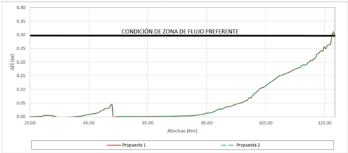
Figure 7 Variation of the water level for a Rt of 100 years between the proposals Riparian Buffer Zone and the hydrological component. Section: Timba River - South Interceptor Channel.
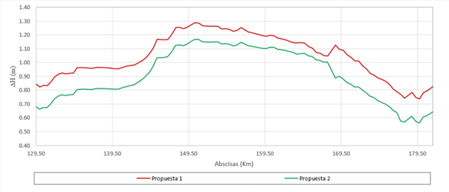
Figure 8 Variation of the water level for a Rt of 100 years between the proposals Riparian Buffer Zone and the hydrological component. Section: South Interceptor Channel - Amaime River.
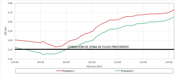
Figure 9 Variation of the water level for a Rt of 100 years between the proposals Riparian Buffer Zone and the hydrological component. Section: Amaime River - Guadalajara River.
In summary, the riparian buffer zone proposals evaluated do not meet the condition of increasing only 0.3 m water levels with respect to the condition of the flooded area for a growing period of 100 years without protection works. Although the behavior of the speed of water indicates that there are no increases in it, the area called dangerous zone is quite extensive for the current situation of the territory.
It is important to highlight that the flood maps are hypothetical scenarios of very critical situations, where the Cauca River is considered to have a 100-year return period flood along its hydrometric stations, which according to the hydrological behavior of the Cauca River basin has a very low probability, since the behavior of the hydrology of the tributaries to the Cauca River is not homogeneous, and its response depends on the physical characteristics, such as the slope, area, and vegetation cover of each basin. For example, in 2011 at La Balsa and Juanchito stations the flood corresponded to a return period of less than 6 years, and at the Mediacanoa station a 27-year return period flood, and in the 1999’s flood at the stations La Balsa, Juanchito and Mediacanoa there were floods with return periods of 3, 27, and 14 years, respectively.
It is important to take into account that the alluvial plain of the Cauca River has been transformed considerably due to the Cauca River Regulation Project, with an increase in the arable area and agro-industrial development (fundamental pillar in the economy of the Valle del Cauca). The floods of the Cauca River are slow because the increases in flows and levels are gradual. According to the diagnosis of the floods on the Valle del Cauca developed by the CVC in 2014 5, these have occurred not only because the water level has exceeded the crown of the protection dikes but also because the failures of these due to their deterioration, lack of maintenance, and their inadequate location. Therefore, the room for the river is reduced, the water levels and the pressure generated by the dikes are increased, augmenting the risk.
Therefore, in order to achieve a balance between the current situation and the natural conditions of the Cauca River, proposing an area of 25,153 Ha as a riparian buffer zone following the MADS methodology, representing 84% of the alluvial plain of the Cauca River is unfeasible social and economically.
To achieve a balance between the current situation and the natural conditions of the Cauca River along the study section, a riparian buffer zone equal to the area delimited by the ecosystem and geomorphological components is recommended according to the methodology implemented in Spain under the name “Sustainable Fluvial Territory” 26, with an area of 17,662 Ha. With this proposal, the water levels of the Cauca River could be reduced to 0.66 m, compared to the current condition. The delimitation of riparian buffer zone considering the Agreement 052 of the CVC, and the ecosystem component would allow a decrease of 0.57 m with an area of 14,445 Ha.
4. Conclusions
The methodologies proposed in Spain (Sustainable Fluvial Territory), The Netherlands, and Colombia (MADS) are the most appropriate for the delimitation of the riparian buffer zone of the Cauca River in this case because of the following characteristics; the study section corresponds to an alluvial plain, the bank-full flow relates to a return period between 1.2 and 5 years along the study section, the plain has been intervened considerably, and recovering geomorphological freedom is critical to improve the functioning of the entire system including flora and fauna.
When implementing the methodology proposed by the MADS to determine the riparian buffer zone of the Cauca River with the criteria of “Preferential Flow Zone” and “Dangerous Flood Zone”, it was found that the resulting area as a riparian buffer zone would correspond to 84% of the alluvial plain of the Cauca River from its main channel.
The riparian buffer zone proposals evaluated in this research would generate an increase in water levels greater than 0.3 m, with respect to the condition of the flooded area for a 100-year flood without protection works. However, with respect to the current condition, water levels could be reduced to 0.66 m.
When evaluating the hydrodynamic behavior of the two proposals to delimit the riparian buffer zone of the Cauca River, it was found that the second proposal that considers what is established from the geomorphological and ecosystem component would allow a greater decrease in water levels, mainly from the South Interceptor Channel to the Mediacanoa hydrometric station, with respect to the first proposal that considers the Agreement 052 of 2011 and the ecosystem component.
According to the characteristics of the Cauca River along the study section and the results obtained from the mathematical modeling, the methodologies developed in The Netherlands and Spain "Sustainable River Territory" are the most convenient from the hydrodynamic, geomorphological, and ecosystem point of view to define the riparian buffer zone of the Cauca River.
The methodology recommended by the MADS for the delimitation of the riparian buffer zone is the most complete with respect to the ecosystem and geomorphological characteristics. However, when considering the proposal for the delimitation of the hydrological component it was found that for a 100-year return period flood, the riparian buffer zone would be 25,153 Ha from the main channel, which corresponds to 84% of the alluvial plain of the Cauca River.
Therefore, it is proposed as a balance between the current situation and the natural conditions of the Cauca River along the study section to recover the area defined as an ecosystem and geomorphological component, using the methodology proposed by the MADS and the methodologies implemented in The Netherlands and Spain under the name “Sustainable Fluvial Territory”.

