


 English (pdf)
 Article in xml format
 Article references
 Send this article by e-mail
 Cited by SciELO
  Cited by Google
  Similars in
SciELO
Similars in
SciELO  Similars in Google
 Permalink
Introduction
Road expansion is necessary for the socio-economic development of any region because it enables human communities to have access to different remote areas and districts; thus, they stay connected and their transportation of products is facilitated” (Alves et al. 2009, p.1). This continuous growth exceeds 50 % of the Earth’s land surface (Hooke et al. 2012).
However, “the negative effects of a road are immediate” (Baguer and Alves, 2011, p.851): “ecosystems adjacent to a road suffer strong impacts when a road is built or expanded, which usually lacks environmental planning” (Brum et al. 2018, p.126); “the adjacent vegetation is eliminated; and the soils are compacted, which alters the thermal conditions and relative humidity” (Jochimsen, 2005, p.351). Therefore, the impact on biodiversity is very complex since roads are a global concern because it affects the conservation of wildlife, (Cáceres et al. 2010. Forman and Alexander, 1998).
The ecological effects of roads include the discharge of toxic gases, substances such as oils and residues, light and noise pollution that significantly affect the behavior and biology of several species (Tejera et al. 2018), hydrological changes (Jones et al. 2000), introduction of exotic species (Forman et al. 2003) and loss of habitat or habitat fragmentation adjacent to a road in small areas (Kuykendall and Keller, 2011). These dynamics alter the exchange of genes as mentioned by Smith-Patten and Patten, (2008) “since roads have become barriers for wildlife movement that prevent gene exchange” (p.844), Therefore, isolated communities are more susceptible to the decline of their population and become vulnerable to local extinction (González-Gallina et al. 2013) due to inbreeding processes caused by geographical and genetic isolation.
The large amounts of roadkills are the consequence of the direct impact of roads on biodiversity (Santos et al. 2013). All species, ages, and sizes of animals are affected by roads (Smith-Patten and Patten, 2008), especially young animals in reproductive stages. Although roadkills may not affect many populations, it can have a significant impact on endangered species populations (Glista and Devault, 2008). It is estimated that one million animals die every day in the different roads of the United States (Litvaitis and Tash, 2008). In the last three decades, roadkill overtook hunting as the main cause of wildlife mortality (Forman and Alexander, 1998).
Other impacts of roads on biodiversity, such as fragmentation have promoted various studies (Trombulak and Frissell, 2000; Puig et al. 2012). The spatial distribution and information collected about wildlife roadkills will contribute to the identification of biodiversity corridors, along with the different routes (Beckers, 2008). Georeferencing of roadkill points is fundamental to design and develop solutions to this problem. Consequently, several studies related to this subject have been carried out around the world (Cserkész et al. 2013; Mizuta 2014).
In Latin America, research related to roads and biodiversity is still a novelty, therefore, related information is scarce (González-Gallina et al. 2013). In Colombia, the study of wildlife roadkill is incipient, although there is some research carried out in the Caribbean region (Dela Ossa Nadjar and De la Ossa V, 2013; Monroy et al. 2015; De la Ossa-V. and Galván-Guevara, 2015), in Popayán (Castillo-R., et al. 2015) in the Magdalena Medio (Ramos Pallares and Mesa Joya, 2018) and in the Colombian Coffee Axis (López-Herrera et al. 2016).
Consequently, this matter needs to be researched in the Department of Huila in order to identify the number of affected species by roadkills in a road circuit of the Department. Reliable information on the matter will allow to understand the root of problem and provide possible structural and non-structural alternatives to mitigate its impact.
Methods
This research was developed over the course of three months, from October to December of 2017, which includes the second rainy season. The information was collected once a week on Wednesdays; a total of 13 samples were obtained by a motorcycle rider who made observations at a speed of ≤ 30 km/h by looking at both lanes in search of roadkills. In addition, a campaign was conducted in the community by means of informative brochures about the registration of wildlife roadkills. At the time and place of a roadkill, a spreadsheet was used to record on-site data such as body length (Cm) (estimated with a measuring tape), weight (Kg) (estimated with a digital scale), coordinates (determined with a GPS), sex, common name, state of the body and its environment; additionally, photographs of the specimen were taken with a digital camera.
Sampling Area
The sampling area is 54.22 km of the road that connects the municipalities of Neiva, Rivera and Campoalegre, a two-way roadway that turns into a dual carriageway. This route was divided into 4 tracks for better study and comparison as follows:
Track 1. Neiva (2°53’55.06”N 075°16’47.85”W) Rivera (Los Cauchos Tollbooth) 45 05 reference point (PR) 98 + 500 (2°45’22.70”N 075°18’30.51”W). It goes through the town center of Río Frío. This is a two-way first-order road (INVIAS, personal communication, January 29, 2018). This fully-paved section has a length of 16.4 km. The speed limit is 90 km/h in most sections; only a few sections have lighting.
Track 2. Campoalegre (2°41’56.03”N 075°19’11.96”W) Rivera town center (2°46’36.84”N 075°15’42.76”W). This two-way road goes through the town center of Riverita. The section comprises two roads that have been categorized as first and third-order roads (INVIAS, 2018). It is a fully-paved section that measures 14 km, the speed limit is 30 km/h all along, only a few sections have lighting.
Track 3. Rivera town center (2°46’44.84”N 075°15’38.26”W) Rivera road intersection (National Road) (2°47’40.26”N 075°17’59.75”W). This is a two-way second-order road (INVIAS, 2018); it is fully paved. This 4.72 km track does not have speed limit signs and only a few sections have lighting.
Track 4. Rivera town center (2°46’55.14”N 075°15’20.50”W) Neiva (2°54’33.25”N 075°16’29.41”W). It crosses the population centers known as El Guadual, La Ulloa and El Caguán. This is a two-way second-order road, (INVIAS, 2018). This 19.1 km route is fully paved and does not have speed limit signs and and only a few sections have lighting. It is noteworthy to mention that there were not wildlife crossing signs in any of the tracks studied. The tracks are differentiated by color (Fig. 1) and their characteristics in terms of track, length, and locations are shown in Table 1.
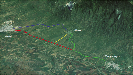
Source: Edited by Google Earth Pro, 2018.
Figure 1 Map of the study area Jun- 20 -2017 by Garzon, Y. Canon Camera.
Table 1 Length and coordinates of sections investigated.
| Stretch | Section | Length (Km) | Colour | Start | End |
|---|---|---|---|---|---|
| 1 | Neiva - Rivera (toll Los Cauchos) | 16.4 km | Red | 2°53’55.06”N 75°16’47.85” W | 2°45’22.70”N 75°18’30.51” W |
| 2 | Campoalegre Urban center of Rivera | 14 km | Green | 2°41’56.03”N 75°19’11.96” W | 2°46’36.84”N 75°15’42.76” W |
| 3 | Urban center of Rivera - Rivera intersection (National Road) | 4.72 km | Yellow | 2°46’44.84”N 75°15’38.26” W | 2°47’40.26”N 75°17’59.75” W |
| 4 | Urban center of Rivera - Neiva | 19.1 km | Blue | 2°46’55.14”N 75°15’20.50” W | 2°54’33.25”N 75°16’29.41” W |
Source: Compiled by authors.
Analysis of the Information
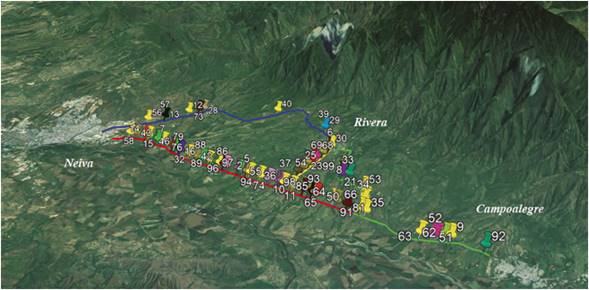
For the analysis of the information collected, the books Guía de las Aves de Colombia (Hilty and Brown, 2001), Guía de Indentificación de la Fauna Silvestre Colombiana (Min. Ambiente and CAM, 2009), and the reptile database (Lynch, Sierra and Gómez, 2014) were used. Also, El Libro Rojo de Reptiles de Colombia (Morales-Betancourt et al. 2015) as well as the Red List of Threatened Species website (UICN, 2019) were used for species identification. Additionally, as proposed by Clevenger et al. (2002), the roadkill spots were identified, and the link between habitat and geographic information system (GIS) was modelled to determine the location of the structures designed to mitigate the impact on wildlife. Google Earth Pro software was used to locate the number of dead specimens that were classified with different colors according to the species; a map of the spatial distribution of the wildlife-vehicle roadkills was drawn (Fig. 2).
Results
The analysis showed that there were 100 wildlife-vehicle roadkills from October to December; it was necessary to include two more animals in the database because they were big and important species, although they were found outside the designated timeframe. Therefore, the total number of roadkill animals by vehicle collision was 102.
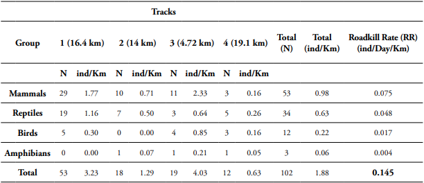
Table 2 shows the classification of wildlife-vehicle roadkills records according to the threat category reported in the red books (which showcase threatened species), the number of roadkills per track, and the total amount. Likewise, Table 3 shows the roadkills by taxonomic group according to number and percentage in each track.
Table 2 Wildlife-vehicle roadkills in the road circuit Neiva - Rivera - Campoalegre.
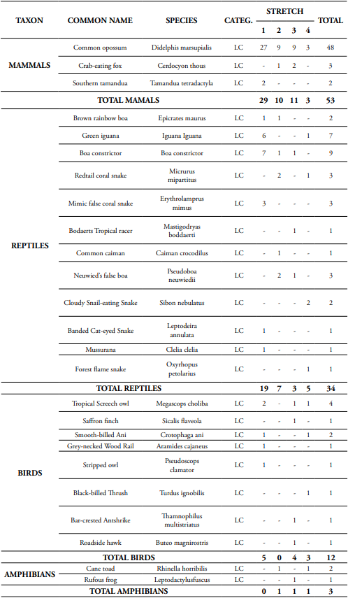
Source: Compiled by authors.
Table 3 Records of roadkills per each taxonomic group in relation to 4 tracks.
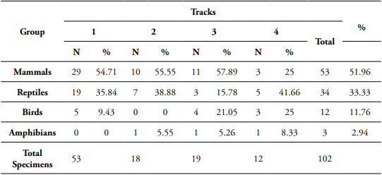
Source: Compiled by authors.
Regarding the records taken in all of the tracks, the following information was obtained: in track 1 there were 53 wildlife-vehicle roadkills in the group of mammals that have the highest mortality rate; the D. marsupialis species was the most affected with a record of 27 roadkills. The second most affected taxonomic group were reptiles with a total record of 19 roadkills, and the Boa constrictor had the highest number with a record of 7 dead specimens.
In track 2, there were 18 roadkills. Mammals were the most affected with 10 roadkills, and the D. marsupialis species had a total of 9 roadkills. Reptiles were the second most affected group in this section with a record of 7 roadkills; M. mipartitus and P. neuwiedii had 2 roadkills each.
In track 3 there were 19 roadkills. Mammals were the most affected, the D. marsupialis species had 9 roadkills. Birds were the second most affected group with 4 roadkills. The species of birds affected in track 3 were S. flaveola, B. magnirostris, M. and T. choliba multistriatus with one roadkill each.
In track 4 there were 12 roadkills. Reptiles were the most affected with 5 roadkills, and the species S. nebulatus were the most affected with 2 roadkills. Birds (Turdus ignobilis, Megascops choliba and Crotophaga ani) and mammals (D. marsupialis) had 3 roadkills each.
A roadkill rate (RR) of 0.145 individuals/km/day, and the detailed information per every taxonomic group were obtained with the data collected from roadkills in the different tracks, considering the length and frequency of 13 samplings (Table 4).
One of the main evident causes of roadkills is high traffic flow (Ruiz-Capillas et al. 2015). This was corroborated with the information given by the administrator of ALIADAS in the Los Cauchos tollbooth (personal communication, January 29, 2018): average daily traffic (ADT) of 5,372 vehicles per month.
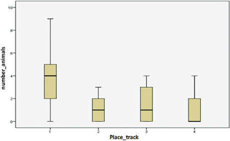
A statistical test of normality was administered to the data obtained from the different sections. However, the data were found to be non-parametric. As a consequence, an ANOVA test could not be carried out. A Kruskal-Wallis test was used instead and the results can be detailed in Table 5 and Table 6.
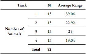
Tabla 6 The Kruskal-Wallis test results.
| Number of Animals | |
| Chi square | 13.651 |
| GL | 3 |
| Asymptotic sig. | 0.003 |
Source: Compiled by authors.
Since non-normal data were found, the Kruskal-Wallis test was used and the results are shown in Figure 3; they show that track 1, compared to other tracks, is the most prone to wildlife roadkills, since the average for track 1 was 4.08 and the maximum was nine animals, followed by track 3, with an average of 1.46 and a maximum of 4 roadkills.
The information collected from the animals was uploaded to Google Earth Pro for a better visualization, then a number and a different color were assigned to each species. This classification facilitates the location of different species and areas prone to roadkills in the Neiva - Rivera - Campoalegre road circuit (Fig. 2).
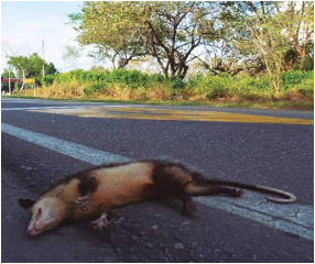
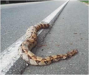
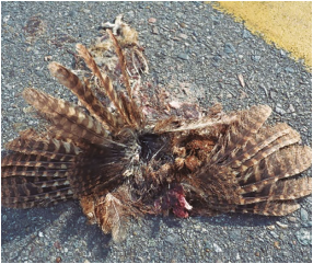
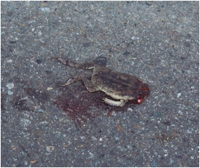
Mammals had the highest number of roadkills with 51.96% (3 specimens), whose species D. Marsupialis was the most affected with a total of 48 killed specimens (Fig. 4). The sex of 31.25% of the individuals was identified, 14.58% were males, and 16.66% were females. Reptiles were the second most affected group with 33 killed specimens. The B. constrictor was the most affected by roadkills (Fig. 5), followed by I. iguana. Birds were the third most affected group with 11.76% and 8 species; M. choliba was the most affected group with 4 individuals (Fig. 6); amphibians were the least affected group with 2.94% with 2 individuals of R. horribilis (Fig. 7).
Discussion
The studied roads are characterized by the fragmentation of land extensions for agricultural production activities that provides a favorable environment for different species. These roads also show lack of environmental management measures and poor lighting. Forman and Alexander (1998) and Gagné et al. (2015) claim “the average daily traffic (ADT) and speed are the main causes of high wildlife mortality” (p.214) (p.1012). These factors may have been the cause of the 53 roadkills in track 1, with respect to 19 in track 3, 18 in track 2 and 12 in track 4.
The most affected species was D. marsupialis, a result similar to the findings of the research by Castillo-R., et al. (2015) on the Panamerican highway. These authors claim that high number of deaths of marsupials can be attributed to the great presence of this species in the region and to its ecological niche that includes the fruit coming from adjacent trees and dead animals on the roads; besides, nocturnal animals are blinded by car headlights (De la Ossa-V. and Galván-Guevara 2015). Another cause of death of this animal is poor waste management (Arroyave et al. 2006), since waste is thrown and accumulated on the side of the road, which attracts several species and makes them vulnerable to roadkills.
The results of this study show that most wildlife roadkills belong to the group of mammals, affecting mainly the D. marsupialis, which coincides with results obtained in Argentina (Bauni et al. 2017), and Brazil (Reynie Omena et al. 2012), who also have similar results to those of Gumier Costa and Sperber (2009), Seijas et al. (2013), De La Ossa Nadjar and De La Ossa V. (2013) and Delgado-Vélez (2014). These results refer to animals that get blinded by car headlights and, therefore, they become more vulnerable to this problem (Delgado-Vélez, 2007, Castillo-R., et al. 2015).
Similarly, 12 species of reptiles were registered, representing 21.43% of the species registered in the department of Huila (Vera-Pérez et al. 2017). It is likely that roadkills are due to the rainy season. Since poikilotherms need to regulate their body temperature by absorbing heat from the environment, they rest on the pavement to benefit from the heat that has accumulated due to sunlight (Mendoza and Marcos, 2016). As Pragatheesh and Rajvanshi (2013) mentioned “the locomotion of snakes is very slow on the pavement” (p.20) and some of them stop moving when a vehicle approaches, which exposes them to roadkills (Castillo-R., 2015).
The number of roadkills recorded is greater in main roads between the municipalities of Neiva and Rivera because there is greater presence of riparian forests that offer a great variety of resources. According to Castillo-R. (2015), wet forests hold more diversity of species than dry forests since they have the adequate environmental conditions for the development of species; therefore, many of the animals of the tropical dry forest migrate to humid areas or even look for a riparian to get better environmental conditions.
The time that an animal’s corpse remains on the road has to do with three main aspects: the presence of scavengers, the weather, and traffic flow (Santos et al. 2011, Ratton et al. 2014). The number of killed animals on the roads can vary because some of them crawl or reach for the adjacent vegetation where they die later (Brum et al. 2018). In the case of amphibians, the time their bodies remain on the road after a roadkill is very short (Antworth et al. 2005) and it may be due to any of the factors previously mentioned. This study may have some margin of error, for example, only three specimens were registered in the amphibian group.
The deaths of animals on the road are analogous to the catch per unit effort (CPUE) where “catch” is the number of animals run over and “effort” is a direct function of vehicular traffic. If the traffic increases, a decrease (or stagnation) in the RR is interpreted as a decrease in the population of the analyzed species (Seijas et al. 2013, Monroy et al. 2015).
The RR equals 0.145 ind/day/Km, a key figure very similar to 0.160 reported in the study conducted by Monroy et al. (2015) in the Caribbean region during the rainy season, which was developed under similar weather conditions to this study, but with different species recorded since the type of ecosystem is different. Mammals obtained a RR of 0.02, lower than this research (0.075). This could be attributed to the fact that the Andean region offers more resources to mammals in its ecosystems compared to the Caribbean region. However, the RR of amphibians was 0.096, which was higher than the one obtained in this research (0.004), contrasting values that reflect the problem of wildlife roadkills in different ecosystems.
Recommendations
Habitat connectivity structures have been implemented by some projects that look for the construction of a new road or even the extension of it (Clevenger and Waltho, 2000), in fact, the Neiva - Rivera - Campoalegre road circuit is projected as a dual carriageway, which is why the collected information about roadkilled wildlife should be considered in order to determine the structural and non-structural strategies that contribute to the mitigation of this impact. Figure 3 shows several areas with high records of wildlife roadkills, where mammals and reptiles are the most affected groups, which calls for their preservation.
In this case, the species Didelphis marsupialis, which is the most affected by roadkills, requires projects or actions for its conservation, since according to Rueda et al. (2013) “opossums play a very important role in the trophic chain as predators, scavengers and the prey of nocturnal birds” (p.150); they are also medium-sized mammals. Furthermore, Clevenger et al. (2001) claims that underpass tunnels could help mitigating the impact of roadkills in the pathway to small and medium mammals (p.1347) and the conservation of the species Didelphis marsupialis. These structures must not be installed in sharp bends or speed bumps since vehicles circulate at low speed and generate higher and more frequent noises, one of the factors that affect the behavior and reproductive cycle of wildlife (Warren et al. 2006). This is one of the main factors that causes greater ecological impacts to wildlife and produces several effects such as reduction of the activity area and low reproductive success, associated with hearing loss, displacement, and increase in stress hormones (De la Ossa-V. and Galván-Guevara, 2015).
Taking into account the recommendation by Clevenger et al. (2001) to improve the permeability of roads for small and medium mammals, the first sewers should be located at more frequent intervals (150-300 m) to provide sufficient opportunities for animals of all sizes to avoid crossing heavy traffic roads. The diameter of the underpass tunnel will highly depend on the size of the fauna in that location (p.1347); in this case, for the species D. marsupialis it would be a diameter of 24”, but considering that other mammals such as C. thous and T. Tetradactyla also suffer the impact of roadkills, it would be good to extend the underpass tunnels to 36”, thus giving a benefit to the different species of mammals affected in the studied route.
Reptiles are very vulnerable to being collided in the rainy season because they are ectoderms (Vargas Salinas et al. 2011, Ramos Pallares and Mesa Joya 2018). “They also have many characteristics that increase their probability of being involved in vehicle roadkills, such as age, sex, body size, activity pattern, household size, food search strategy, defense mechanism, habitat requirements, among others” (p.123) (p.87); Therefore, another strategy to benefit reptiles in the rainy season would be to pave certain places next to the road or to create an area for wildlife to take the sun safely (Pragatheesh and Rajvanshi, 2013).
Finally, trees adjacent to the road meet and create green tunnels that allow wildlife to cross to other ecosystems that have been fragmented due to road construction (Cypher, 2017), therefore, cutting and removing them from roads can significantly reduce the species preservation. This phenomenon could potentially increase the risk of roadkills (Grilo et al. 2011).

