


 English (pdf)
 Article in xml format
 Article references
 Send this article by e-mail
 Cited by SciELO
  Cited by Google
  Similars in
SciELO
Similars in
SciELO  Similars in Google
 Permalink
1. Introduction
When the leader of Tiwiram -a Shuar village founded in the late 1970s- goes to town, he never fails to wear a T-shirt emblazoned with the slogan Somos Amazonia ("We are the Amazon") displaying the five colors of the five indigenous Amazonian nationalities. Indeed, the Shuar community, named after its founder, does not identify itself as indigenous. The village is in the parroquia1 of Dayuma, province of Orellana, northern Ecuadorian Oriente,2 whereas Shuars were originally from the southern provinces. This area is recognized as historically falling within the Huaorani territory by both contemporary Shuars and decentralized local governments (parroquia and province alike).
The Shuars from Orellana use the term "autochthon" for referring to the Huaorani, not to themselves. Indeed, displaced from the province of Morona-Santiago for approximately 40 years, the Shuars prefer to identify themselves as Amazonian natives, homogenizing the culturally heterogeneous Amazon into a collective identity. The 2009 Ecuadorian constitution refers to Huaorani, Kichwa, Shuar, Siona-Secoya, and Ai'Cofan in the northern Oriente as the "indigenous nationalities of Amazonia."- It is intuitively understood that this identification, "indigenous" and "Amazonian," is much appreciated by the Tiwiram leader. How can we understand the visible desire for a common identity? The purpose of this article is to analyze the construction of this "ecological" identification, which overcomes (in a way) the most used ethnolinguistic examples.
In the Oriente, the term "autochthon" is not used in identity claims: people are "indigenous" (indígenas) when they have an ancestral culture, values, or lands, but things mix up internationally: the United Nations Declaration on the Rights of Indigenous Peoples (UNDRIP, voted on September 13, 2007) is called the Déclaration des Nations Unies pour les Peuples Autochtones (DDPA) in French (the UN's second language), and the Declaración de las Naciones Unidas sobre los Derechos de los Pueblos Indígenas (DNUDPI) in Spanish.
In legal terms, Ecuadorian law has taken over the issue of indigenous rights, driven by 25-year-old powerful indigenous movements. The 1998 constitution thus recognizes the nation's pluricultural and multi-ethnic nature (Bosa & Wittersheim, 2009). The current one confirms this transition by conferring rights to communities, peoples, and nationalities,3 facing the colonization of colonos, the settlers coming from the Sierra and the Costa. Ecuador's government has produced many executive decrees, constitution articles, organic acts, and ministerial agreements on the subject (Table 1). It questions law uniformity throughout the national territory and the equality of citizens before the law.
TABLE 1: A HISTORICAL PERSPECTIVE OF SOCIAL AND LEGAL EVENTS AFFECTING SOCIETY AND THE ENVIRONMENT IN THE PARISH OF DAYUMA: A SELECTION OF CRUCIAL EVENTS.
| Social events | Legal events nationally and internationally | Governmental and presidential decrees | |
|---|---|---|---|
| Before 1962 Pop. ~< 55 inhabit. Density ~< 0.04 inhabit. /km² | Prospecting for oil by Texaco Evangelization of natives (Limoncocha) |
Comunas Act (1937) | |
| The 1960s Pop. ~ 330 inhabit. Density ~ 0.27 inhabit. /km² | First settlements of colono familiesbrought by a military plane | ||
| The 1970s Pop. ~ 3,200 inhabit. Density ~ 2.64 inhabit. /km² | First oil roads built First exploitation of oil fields First colonization programs |
||
| The 1980s Pop. ~ 11,500 inhabit. Density ~ 9.32 inhabit. /km² | The peak of both colonization and oil production High cocoa and coffee prices |
Indigenous Nationality Act (1985) | |
| 1990-2006 Pop. ~ 17,500 inhabit. Density ~ 14.14 inhabit. /km² | First protests against oil exploitation, Texaco trial | Environmental Management Act (1999) Contamination Prevention and Control Act (2004) |
Environmental Regulations for Hydrocarbon Operations (RAOHE, 2001) Regulation for indigenous peoples’ consultation and participation (2002) |
| 2006-2009 Pop. ~ 15,600 inhabit. Density ~ 12.60 inhabit. /km² | Indigenous movements structured Peak and decline of liberal monetarist policies “Dollarization” Slowing down or even reversal of colonization fluxes |
Constitution of 2008 Art. 407: Extraction of non-renewable resources, including logging, is prohibited in protected areas and areas declared untouchable Art. 56: Natives are citizens with equal rights and group rights (land ownership, use, and allocation). Art. 57: Definition and specific procedure for indigenous peoples in voluntary isolation United Nations Declaration on Indigenous Peoples (DDPA, 09/13/2007) (Articles 25 and 26) Approval of the exploitation of the Yasuní National Park on 03/10/2013 Guidelines on the Protection of Indigenous Peoples in Voluntary Isolation and Initial Contact of the United Nations High Commissioner for Human Right s |
Inter-Ministerial Agreement 120 (2008): Code of Conduct applied to oil companies operating in areas bordering Tagaeri-Taromenane and their buffer zone Executive Decree 419 (06/2007): Public policies for the protection of Tagaeri-Taromenane peoples |
| After 2009 | Amendment to the Hydrocarbons Act (2009) Art. 94: 12 % of surplus production allocated to GADs Organic Act of the Amazonian Territorial Division (2011) |
Presidential Decree 552 (18/11/2010): Intangible Zone in the Yasuní National Park, between the Yasuní and Curaray shores Inter-Ministerial Agreement 33 (2013): Implementation of the Plan for the Protection of IsolatedIndigenous Peoples |
Source: Own elaboration.
In practice, however, this tangle of legal rights, practices, and perceptions related to territory and resources are the living reflection of this confusion: there are as many territories and many perceptions of identity as identities in the Amazonian Oriente. This is the convergence of two extremely coherent systems: identity and community self-perception on the one hand and equal rights and political structuration on the other. As noted above, the latter remains the corpus of the nation-state. The former is the product of these rising self-structured indigenous movements,6 initially under the Buen Vivir slogan.7 The reason why the convergence between the buen vivir citizenship and the indigenous self-structuration struggles for rights is non-consensual, to say the least, is that the difference between these two structured ideologies has a practical impact on the exploitation of the territory's oil resources, vital for the state with 70 % of the national budget and 51 % of exports. Consequently, we propose to explore the contradictions that these two paradigms render unclear. The purpose of the article is then to explore the history, perceptions, and practices of indígenas and colonos but also their access to legal rights, leading us to some hypotheses on this conjunction.
2. Methods, fieldwork, and bias
To clarify our positioning, the research producing these results was supported by several funds and fellowships. The Franco-Ecuadorian MONOIL cooperation project provided a diagnosis and prospective modeling of the Oriente environment, especially for oil pollution. It is funded by the French National Research Agency (ANR) and supported logistically in Ecuador by the Research Institute for Development (IRD).
2.1. Anthropologic research
An ethnographic observation work was conducted between April and July 2015. The first idea was to determine the social changes in the indigenous communities of Dayuma (Orellana, Ecuador). Over the past forty years, oil exploration and production have defined the rationality, intensity, and dynamics of colonization and opening by clearing the entire territory. The aim of this paper is to understand how ecological impacts are perceived and translated into subsistence and practices. The method combines the following elements:
Life stories and semi-structured interviews about subsistence strategies, landscape change, and land use. Interviews were conducted with 23 members of approximately fifteen domestic units in the Shuar community of Tiwiram;
Participatory observation8 (DeWalt & DeWalt, 2011), for subsistence activities, food preparation, and consumption, to cross-check the information gathered during narrations and interviews;
Systematic ethnobotanical and ethnozoological interviews, including a collection of the ethnobiological lexicon by free list (Borgatti, 1999; Weller & Romney, 1998) of known or used animal and plant species. This is a pathway for researching local categorizations of the territory in use.
The purpose of this method combining ecological knowledge, subsistence practices, and narratives is to access every facet of the term "pollution" and situate it within a set of changes that are directly or indirectly related to oil activities.
Indeed, studying ecological knowledge provides access to the local perception of pollution over trophic chains and the spatial categorization of natural resources: we explored food and health practices, including supply practices (in town, in local groceries) and spatialize them, thereby spatializing as well locations and circulations of subsistence resources, monetized or not.
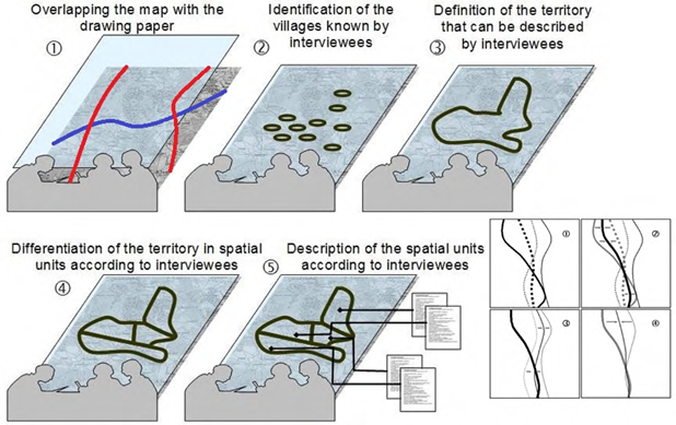
2.2. Perception-Based Regional Mapping
The Perception-Based Regional Mapping (PBRM) is a participatory method for spatializing environmental, sociopolitical, and health issues in six stages (Figure 1; Maestripieri & Saqalli, 2016; Saqalli et al., 2009). Each participatory map is geo-referenced9 in a Geographic Information System (GIS), and the associated criteria are recorded in an attribute table.10 The spatial circumscription does not intend to be precise (Silva et al., 2019) but, along with participatory interviews, allows us to define diverse issues more accurately and with adequate topology as a result of their recurrences. The result is the interviewees' hierarchy of factors describing the territory. It also allows comparing or crosschecking with external data to estimate the level of perception's accuracy.
2.3. Rural and agricultural assessment
This assessment shows the diversity of rural families in Dayuma. The study was divided into four main stages:
Identifying agroecological conditions (climate, topography, soils) to understand the Dayuma territory and its homogeneous agroecological zones, each of which affects farming potentials. This was carried out through "grey" literature (NGO reports, theses, GAD publications, databases, among others.), together with field observations, trips,11 and transects,12 corroborated by Google Earth images.
Repositioning the study area in the broader context of its region and country based on published literature, particularly the legal aspect of land tenure and the spatial, economic, and social organization of productions.
Reconstructing its agrarian history relying on factors, events, and finally reasons that led to a differentiation between producers and new occupations or types of occupations in this territory; and revealing past and ongoing local dynamics through interviews with people who have lived in the area for a long time and witnessed periods of change.
These three stages resulted in a draft typology of agricultural situations that enabled us to build a reasoned sampling to delve into the study of production systems. The interviewed producers were selected according to their technical-economic situations and social characteristics. The study of production systems concerns the functioning of farming systems and their interactions (Mazoyer & Roudart, 1997). It means observing and interviewing farmers about their practices and decisions to obtain access to overall day-to-day operative production system rationalities. At least three producers were interviewed for each of the identified production types. Information and data were collected using semi-structured and open interviews with 60 farmers between April and August 2015. The interviews addressed various topics (family paths, technical itineraries, dynamics, constraints, and forces). Attention is paid to the perceptions of agriculture by interviewing 14 more people in contact with but not engaged in farming, such as unionists, politicians, or agricultural technicians, especially those in charge of local projects (GAPO,13 GADMFO,14 and MAGAPE15). The sample (N = 74) was designed to capture diversity rather than to be statistically representative.
2.4. Legal census
A census is assessed on the existing organic laws, acts, and constitutions, the most recent dated September 28, 2008, and the various inter-ministerial agreements, executive decrees implementing laws, and conventions signed by Ecuador. This type of systematic census helps us position both the colonization and the political processes in its legal chronology.
2.5. Combination and bias: Issues and constraints
We present the results of several PBRM campaigns conducted between 2013 and 2015 along with those conducted during two 5-month M.Sc. student-training courses in anthropology and tropical agronomy in 2015 and the legal census. All combined support the reconstruction of these differential territory perceptions.
The biases that we present below are common and even elementary in any socio-anthropological research. None is significant enough to discredit this paper. Taken together, however, they may be strong enough to have a significant impact on the results.
Numerous words can be confusing due to their various meanings in context ("cultivated fields," "fields to be cleared," or "crop-friendly zone"). Therefore, when answering the question, "Can you list all the animals that live here?" some people asked if they should also give the names of birds and fish. Similarly, some mentioned insect names in response to the question "What does this animal eat?" but did not include them in free lists because of the restrictive nature of the term "animal," which was tacitly understood by the researcher as a "terrestrial animal," not the "animal species" in its broad sense. Indeed, among the communities of the Shuar and Ashuar groups, "fauna covers an extensive nominal system made up of multiple generic categories" (Descola, 1986, p. 105), implying that correspondences between these two systems were rapidly discovered. Finally, it should be noted that, although everybody speaks Spanish, mother-tongues may affect the individual's understanding; therefore, most interviews and participatory observations were conducted in Spanish;
Many individual interviews took place in the presence of neighbors, family members, or friends, which is socially impossible to avoid. Their presence produced responses that were obviously intended for that audience: interviewees are aware of their critics, the conflicting part of the local context, and enhancing consensual rules. Thus, the most proficient qualitative data, even if bias creeps in, came from young adults, from marginal families: they tend to describe the political and sociological local situation into a less consensual and "politically correct" tone, and they are usually not surrounded by curious neighbors;
The institutional proximity between administrative documents (particularly the convention allowing us to work in Ecuador) and the Ministry of Environment (MAE) suggests a problem because the MAE is not very appreciated and is suspected of collusion with oil companies. In contrast, the MAGAPE is received with less distrust.
3. Results: Tangles of representation
3.1. A short but meaningful history of practical spatial segregation
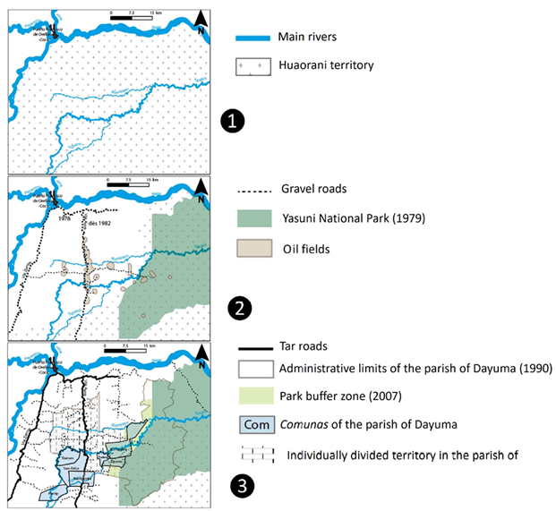
Until the end of the 19th century, the northern part of the Ecuadorian Amazon was occupied by different groups of rotating slash-and-burn farmers-hunters-gatherers (Cofán, Siona, Secoya, Huaoranis, Taromenane, and Tagaeri). The Huaoranis lived between the Napo River and the Curaray River, currently known as Dayuma,16 and are still present on the edge of this territory, especially in and around the Yasuní Park. The literature on these groups' lifestyles is primarily the work of anthropologists in the third quarter of the 20th century, including Harner (1977) and Descola (1986), who studied the Shuar territories further south (Figure 2.1).
Source: Own elaboration.
Figure 2 A spatial representation of the history of Dayuma, Orellana (WGS 1984/Zone UTM 17 south).
Agrarian reforms (1964 and 1973) were aimed at correcting the land inequality of the lati- and minifundium system17 of the coastal and Andean part of the country, but primarily constituted the opening of agricultural borders on the coast and the Amazon.18 This colonization benefited from the oil boom that made Ecuador the second-largest oil producer in Latin America. This discovery, which occurred after Texaco Gulf Oil had been exploring oil fields (since 1967) and then after the 1973 and 1979 oil shocks, favored colonization by opening roads in the forest.19 Naturally, this colonization was supported financially and logistically by successive governments, using trucks, buses, and even airplanes.
After a prospecting campaign south of the Napo River, the Vía Aúca20 was opened. It was a dirt track from the town of Coca, north of the Napo River, that led south (Figure 2.2). This track was first built until the Tiputini River, allowing colonos to settle before but also beyond this river (Figure 2.2).
Using these opening tracks, settling families, called colonos, accessed property in Oriente. Private law applied everywhere except for the newly funded indigenous comunas (Figure 2.3 and Table 1), where most of the Kichwas settlers and Shuar refugees settled. Nevertheless, they mostly arrived with little capital and first established food crops. In less than half a year, they planted coffee: prices were remunerative, and plants were accessible and adapted to the local ecology. Some families cultivated approximately ten ha of coffee, allowing them to pay for more labor (Eberhart, 1996).
The price of coffee collapsed after 1989, and with the spread of the coffee borer beetle (Hypothenemus hampei), coffee was gradually abandoned, especially after 2001, despite a succession of public supporting but ineffective projects. The most favored producers in terms of accessibility, capital, and labor, shifted toward extensive livestock farming on permanent grasslands.21 Others relied on what could be done -namely, small livestock and cocoa-growing22- and attempted to find salaried positions, usually short-term jobs with oil service companies or other farmers. Some even left their farms for the city of Coca or beyond.
The Amazon plan for agricultural colonization provided for privately-owned comunidades23 with 50 ha lots per settling family.24 Settlers first occupied land near roads. Once saturated, a second line was opened 2 km deeper in the forest and so on, with lines coarsely perpendicular to the Vía Aúca (Figure 2.3). These families did not have equal amounts of workforce25 or equal knowledge of the Amazonian environment, particularly weed, parasite, and cryptogam control. In the face of these dynamics, Huaorani groups migrated further south and east following numerous clashes with oil tankers, loggers, and farmers.
Since then, the zone has primarily been developed through "social struggle," although not necessarily against oil companies,26 which had to change their negotiating method for installing oil infrastructure27 from violent blackmail in the 1980s and 1990s to a combination of divide-and-conquer tactics and financial compensation for communities28 and families. Clashes have been more violent between oil companies and Huaoranis. Once the Vía Aúca was paved, two East-West tracks connected it to the outskirts of the Yasuní Park.29 Legally, Huaoranis are divided into two sets: Tagaeri and Taromenane, or "non-contacted" or "voluntarily isolated" (Table 1), and "contacted Huaoranis" who are slowly settling along the track.
Along the paved road lives a combination of capitalistic extensive cattle breeders (paid labor, pasture, and livestock treatments), mixed (coffee and cocoa) crop-livestock smallholders, retirees, and, only in the province of Sucumbíos, fish farms for urban markets. Road-connected comunas are mainly populated by Kichwas.
The second line is inhabited by less capital-intensive livestock farmers and a growing portion of mixed-farming families, with coffee and cocoa less often supported by public projects.
Further still, we find farming families with fewer cattle and mostly food crops, being cocoa and coffee often sick, not remunerative, and subsequently abandoned. The indigenous portion of the population increases with more non-Kichwa natives.
Finally, the third and fourth lines are primarily populated with indígenas (Kichwa, Shuar, or even Huaorani on the edge of the park), almost all of whom grow food crops.
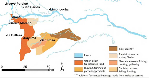
This progressive differentiation is also found in food consumption, where urban processed products disappear as the tar road separates from the first zone, with mostly farm products, which thereafter are progressively replaced with non-timber forest products (Figure 3). Even if the proportion of indígenas grows with the distance to the tar road, social and agricultural practices -apart from the connoted chicha- tend to be the same between indígenas and colonos.
3.2. Indígenas: A well-known but excluded component of the society
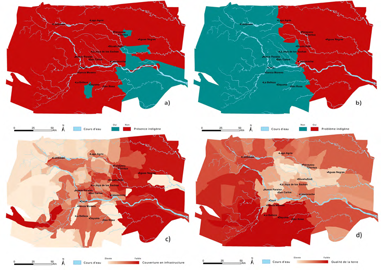
Interviewing non-natives about a territory provides, through the gap between perceptions and reality, information about ethnic differentiation: perceptions may be extremely reductive, full of clichés, and even offensive, especially when most colonos describe an "Aúca" zone (Figures 4a and 4b). Practically, indígenas are located mostly in areas near large national parks (Cuyabeno and especially Yasuní). Indeed, media and local governments promote having Huaoranis that corresponds to the cliché of indigenous people in dedicated reserves. However, in 2010 the INEC (2018) recorded an indigenous population of 13.4 % in Sucumbíos, 31.8 % in Orellana, and up to 77.4 % in Dayuma.
Source: Own elaboration.
Figure 4 PBRM results: a) perceived indigenous people; b) perceived existence of “an indigenous problem;” c) perceived infrastructure cover, and d) perceived land quality. PBRM was assessed almost entirely with non-indigenous people (WGS 1984/Zone UTM 17 south).
This misunderstanding is evident at the provincial level among non-indigenous perceptions of areas with "indigenous problems." Indeed, several conflict cases between indígenas and public authorities or among indigenous groups were highly publicized, with violent episodes such as in 2013 between evangelized Huaoranis and non-contacted Taromenane (Cerretti, 2006; Ospina et al., 2008; Sawyer, 2004). Differences are easily observed with people living in areas where indigenous issues are common (Figure 4b).
Knowing more is ultimately an indigenous issue: it is only them (or their neighbors) who distinguish nationalities. Figure 5a shows the diversity of population types (Kichwa,30 Quichua from the Sierra, Shuar, Cofán, Secoya, Siona, Huaorani, and colonos). This distribution is consistent with government data (Figure 5b), especially where indigenous population prevalence is evident and well known locally, for instance, from south to west, the Loreto cantón, which has an indigenous population of 67.4 %. Another configuration induces a clear perception of indigenous territory in officially protected areas such as the Sequoia Reserve in the Shushufindi cantón. Outside these areas, matters are blurred: north of Sucumbíos, areas officially inhabited by Kichwa and Cofán, are locally described as inhabited by settlers! The Shuar population, east of Coca and north of Lumbaqui and Limoncocha, is inconsistent with the perceived population as well.
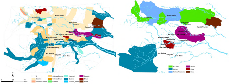
Source: Own elaboration.
Figure 5 (a) Perception by mainly non-indigenous people of the indigenous population distribution and (b) a gap with real data from the government census (WGS 1984/Zone UTM 17 south).
The perception of infrastructure coverage groups several factors (Figure 4c). The eastern part of the study area is poorly equipped because of the presence of the Yasuní Park (southeast) and the Cuyabeno Park (northeast). Some areas that are well served by roads are perceived as poorly covered (east of Shushufindi). The results show that drinking water and road density issues appear as the first criterion. Unpaved roads (in Lago Agrio), access to employment (in Dayuma), and electricity supply (San Carlos and Lumbaqui) are ranked second. Finally, it is noticeable that the area with the most colonos is central Sacha between the two provinces. It is historically attributable to the presence of the largest oil fields in the region but also to its status as the most fertile zone (Figure 4d), thus limiting possible alternatives to the oil-agriculture tandem.
Therefore, to conclude this section, what is seen as a structural divide between colonos and indígenas tends to fade under a hidden but simpler division: the ones having and the ones not having, the ones having access to oil and institutional jobs, roads, and medical, sanitary, school infrastructures, and the ones in remote places, spatially or merely symbolically.
3.3. From the city-country-forest trinity to the city-forest duality
Descola (1986) uses the Ashuar spatial division among house, forest, and rivers to characterize all their elements. We then rely on the Shuar categorization among forest (el monte), country (el campo), and city (el pueblo) to highlight their point of convergence: the supply and exchanges between these worlds. The Shuars from Tiwiram cross these three spaces every day, making the country (or rather, the village) the crossing between the forest and the city. Thus, practices and knowledge are shared, including the differential use of languages according to the location: the Shuar language and ecological knowledge are used in the village and the forest, whereas Spanish is used in both the village and the city and concerns manufactured goods, foodstuffs, and sanitary wares (Figure 6).
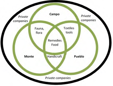
Source: Own elaboration.
Figure 6 A diagram of interconnections and interfaces among el monte, el pueblo, and el campo.
Although oil companies are socially and geographically ubiquitous in this region, they remain geographically on the margins of food and health supply zones. By engaging themselves in communities and forests, oil companies create interstices, hermetic bubbles31 among city, community, and forest (Hoinathy, 2013). However, trade monetization, thanks to the wages of the few men working for oil companies, is now included in this tripartite supply. Paradoxically, the associated pollution does not question the food categories but instead their production places: the three supply zones are the categories the Shuars called upon to justify product quality. Del campo and del monte are considered the healthiest types of food.
However, the system is not stable, and its rural share dissolves: the oil industry eases access to the city through roads and electrical networks and the multiplication of small urban cores. It places cities, particularly Coca, the capital of Orellana, as having the same perceived relative importance as the forest and country in the food supply. Thus, without having oil exploitation sites in the comuna, the main perceived source of pollution is the city itself and, more generally, civilización (civilization). This very schematic shortcut is found in the elders' discourses: civilización contaminates the Shuars from Tiwiram or, more precisely, their traditional way of life and their cultural values. Therefore, the community is representative of this gradation: city products (whether food or care) compete against forest and country ones, sometimes seen as opposed, competing, or complementary. Trade monetization is recurrent in subsistence practices, with oil companies having a major role in driving trade and exchange practices in the community. Indeed, all products, coming from the city, country, and forest, including chicha, can now be sold in the village.
It seems like the closer a community is linked to the oil industry, the more it adopts an urban way of life and, less clearly, a colono-peasant way of life. Therefore, to a newcomer in Dayuma, most indigenous and mestizo communities living from agriculture and livestock are very similar in their housing, clothing, and eating habits. Actually, except for the Huaorani, indigenous peoples of the oil-producing Amazonia define themselves as farmers, with lives close enough to poor rural colonos and facing the same difficulties and struggles.
It is thus in connection with the national policy that this reification of the identity of indígenas is explained. We hypothesize that the concerned communities use their identity claim sometimes against the colonos and mestizos but mostly against the oil industry, with their territorial and de facto ecological legitimacy: Amazonia is the territory of the indígenas.
This position provides an ideological structure to the Somos Amazonía32 movement, which was initially a group of activists in the Ecuadorian Amazon who have been struggling since the 2000s for justice against the 1972-1990 oil pollution33 (Kimerling, 1993; San Sebastian & Hurtig, 2005). The movement and its slogan Somos Amazonía thus unite all of Amazonia's indigenous nationalities, avoiding existing antagonisms such as those between Kichwas, Huaoranis, and Shuars, and opens a dialogue between local and government-elected representatives through organized political events, also known as Somos Amazonía. This perspective has started to be extended and adopted by extra-Amazonian groups who want to be included in Somos Amazonía. Therefore, apart from the strong chicha-consumption cultural divergence, there is little difference in everyday life between indígenas and colonos with the same standard of living. Although the conjunction is not yet defined, the connection between these two groups may be considered a future possibility as far as they share the same rural identity, especially because such identity is fading.
3.4. The legal and segregating ambiguity between comuna and comunidad statuses
As shown in the previous sections, the Comunas Act of 1937 (Table 1) seems to be the only "legal guarantee" for the defense of collective territorial rights. Comunas refers to "any center of the population below the category of parroquia" (Comunas Act, 1931), allowing the indigenous communities to legally protect their land by registering any community, whatever their organization. By avoiding ethnic references, the comuna then became the par excellence indigenous legal form, making people Amazonia peasants (Santana, 1992). In practice, it provides both a clear status for Ecuadorian citizens and a way to preserve collective rights with specificity.
The 2008 Ecuadorian Constitution acknowledges the status of communities, peoples, and nationalities as related to a specific way of life.
Article 56 (Table 1) recognizes these groups as part of the Ecuadorian people. It distinguishes them as indigenous nationalities enjoying group rights in addition to individual rights and subsuming the latter into group laws when considering territory ownership, use, allocation, and priority based on ancestry. The indigenous consuetudinary law is recognized as allowing the administration of another form of justice while respecting the Constitution.
Rafael Correa's 2006 election as president was the pinnacle of the Buen Vivir concept (or Sumak Kawsay in Kichwa/Quechua34). Alberto Acosta Espinosa (2013) formalized this concept as a combination of strong ecological and social concerns, a relatively Keynesian approach, and the recognition of both individual and non-individual rights based on ancestry or autochthony, with a quasi-spiritual component based on an indigenist cosmovision. Although this concept is losing ground within the national government,35 it is being claimed by the indigenous political party Pachakutik36 -the union and political arm of the country's strongest indigenous organization-, the CONAIE,37 and its Amazonian sub-division, CONFENERA38 (Ospina Peralta et al., 2008).
Political positioning, in this respect, is a fundamental, if not a vital, challenge for locally elected representatives in mobilizing public funds to build local infrastructures. The amendment to the Hydrocarbons Act and its Article 94 (known as the "12 % Act") implies the redistribution of 12 % of surplus production among GADs (Juteau-Martineau et al., 2014), but only upon the submission of development projects. This administrative burden already creates a filter between elected officials who have a network of available experts and elected officials who do not. In practice, only the government's Alianza País party membership provides access to these funds. This about-face has a counter-effect, inducing voters to reject such practices and practitioners in parroquial elections, as it happens for the Jefe Parroquial of Dayuma.
This balance in political alignment between pragmatism (if not opportunism) and revolt can be seen at the local level in the management of comunas and comunidades. If the Act of 1937 restricts the choice between these two management forms, they are not all pro-collective. Thus, many indigenous people, especially Kichwa, do not live in comunas:
Choosing the comunidad status allows an individual not to be marked as "native." The interest of this claim is primarily political but also economic, depending on the weight of the state's development aid programs. When MAGAPE supports projects, they are chosen according to their potential as "production projects" (intensive farming, for example) and favors comunidades because of their private property guarantee. Conversely, social projects tend to favor comunas.
Owning one's property is useful in cases in which attachment to one's farm or community is not strong. When, because of an oil prospecting campaign, an oil company wants to build infrastructure and buy the finca of a farmer, the property can be sold39 directly without reporting to other members of the community. 40
In contrast, to live in comuna enables the mobilization of a united front and negotiation strength vis-à-vis the state, but especially against oil companies seeking to prospect or build infrastructures, to obtain the maximum compensation.
In practice, the availability of land per capita is generally much higher in comunas (Morin, 2015). However, families in comunas tend to come closer together through collective work (minga in Kichwa), market days, and the very human need for a social life. It is this practice of commensalism that creates a community rather than a formalist ideology.
Of note is that if Kichwas colonizing the Dayuma region in an individual family mode hesitate between comunas and comunidades, the power gain accompanying comuna status will be privileged by collectively organized Kichwa communities. This situation can be seen not only in parroquias north of Dayuma but also in this one (for instance, the comuna of Rumipamba in Figure 2.3). For the Shuar communities, regardless of whether they adhere to the Federation of Shuar Centers, and for the mixed communities of Kichwa, Shuar, and Huaorani (comunas of Tiputini and Tiguano), the comuna is the "least bad" status (comunas of Nantip, Saar-Entsa, and Tiwiram). Finally, there is a tendency in three non-indigenous communities in both provinces not only to organize mingas but also to get local rights with powerful collective councils, in which the individual choice to sell one's property can be subordinated to the will of the comunidad. Here, we hypothesize that a reconfiguration of the colonos/indígenas binary status may be envisioned, primarily for political reasons, involving a better negotiation ability of all the concerned communities facing public administrations and oil companies.
Therefore, the Somos Amazonía and the comuna status attractive power may be acknowledged even beyond the indigenous circle. Being native is trendy, and the divide between comuna and comunidad statuses may be asked to be solved towards the collective system rather than the a priori more obvious private property status. One may then ask why the choice of such a status is restricted only to some groups.
4. Conclusion: A tacit distinction
What can be said about these different pieces of research? Disparate in their approaches, each emphasizes a certain perspective on indigenous citizenship and territory issues. Nevertheless, the following can be concluded:
At the state level, although the indigenous position has never been so well recognized in legal terms, the risk of folklorization and dispossession as a self-sufficient political actor, with no need for protectors (NGOs, "enlightened" political parties), is significant. For instance, it is difficult for the Pachakutik party to be heard. Politics are still effective, together with public actions (demonstrations, occupations) but only under the indigenous flag. As a practical matter, beyond even President Correa's proposals for a kind of positive discrimination, political dynamics tend to promote what Young (1990) expressed as differentiated citizenship: all citizen rights and claims are to be organized in communities, different from the "all humans as equals" principle. Accordingly, one may find it difficult not to be labeled as an identity, group, or nationality (Radcliffe, 2012).
At the level of provinces and parroquias, indigenous people are now recognized but folklorized: related symbols are included on all administrative emblems; they are referred to, but only in socioeconomic terms. Accessibility to public infrastructure and economic means is still difficult for indigenous people. It is the comuna alone that allows a better-negotiating position facing the main de facto public actor, oil companies (Van Cott, 2001), to the extent that a colono claims that being a native provides strength.
At the community level, the link to the índigena territory, apart from the small Huaorani group (approximately 2,500 people), is at a historic low, at the same level as other settlers. Moreover, this link tends toward a binary scheme between el pueblo, where villagers stock up, and el monte, where one can still hunt and fish, albeit with increasing difficulty. El campo has betrayed its promise of independence: cash crops are no longer remunerative and are regularly ravaged by parasites, maize is difficult to grow, and only cassava is easy. The only rewarding crops are market gardening and livestock, both labor demanding. Apart from the few large colono families along the tar road, it is the indigenous communities, through mingas, that can best mobilize this workforce.
The existence of a campo world is being threatened by colonos' aging (MAE-PRAS (2016) and team surveys). They mostly arrived between the 1970s and 1990s, and their children have returned either to the city, primarily Coca, or the Sierra or Costa. This exodus dynamic (or at least the cessation of expansion) decreases the possibility of a future smallholder countryside. Nevertheless, although both the Comunas Act and private property confer an intangible right to private property, obtaining a land title requires an uphill battle. Meanwhile, natural reserve entitlements and national parks have proven to be the gateway for land and subsoil state appropriation, as shown by the Yasuní-ITT case (Kimerling, 1990, Larrea & Warnars, 2009, Vallejo et al., 2015). Therefore, once the campo identity is at stake, it appears both symbolically, economically, and politically rational to be indigenous.
Therefore, we hypothesize that there is a dynamic toward a pan-indigenous identity claim, not only by indigenous people but also by some colonos. Here lies the main difference between autochthones and indigenes, as a non-formalized categorization in terms of perception and political legitimacy differentiation: indigenous people would be ethnic, and autochthones would be geographical. We will use this formalism without sanctifying it:
Mestizos and ladinos are not identified as Amerindians. Both the external view of them and the representation they provide of themselves do not refer to a cosmovision or a right linking land and people. They are settlers: there is no ambiguity. However, we do see alliances, particularly matrimonial alliances, with persons identified as indigenous.
Huaoranis, Siona-Secoya, and Ai'Cofan: These groups are recognized as indigenous according to all possible definitions.
The last two are well identified as Amerindians but do not carry the legitimacy of historicity; they would not be autochthonous:
The Kichwa are advantaged: they are unavoidable, and their indígena legitimacy is unquestionable. They constitute 85 % of the indigenous population and almost all the executives of the CONAIE, CONFENIA, and Pachakutik party. Moreover, they have a fair historicity argument, having been present in the Oriente since the 16th century (the foundation of Loreto in 1563, Figure 5a).
The Shuar have neither geographic autochthony nor the anteriority of coming nor demographic and political weight. They have been the most fragile. However, indigenous identity is built on the basis that it is more than national: it is also internationalist (Castree, 2004). Consequently, territorial anchoring is important, but the internationalist dimension, in terms of the recognition of indigenous rights, gives more weight to the Shuars than to settlers. This situation, a priori discriminatory against settlers, has its roots in a common identity of resistance fueled by struggles over land ownership, cultural property, and intellectual property (Castree, 2004).
Thus, the meaning of the slogan displayed on the T-shirt worn by the leader of the Shuar community from Tiwiram may be better understood: the inclusion of this community and this group in a wider and stronger community is necessary to confirm its right to remain in the form of a protective community (González, 2010). This community claims to be indigenous but unconnected with autochthony, always in the sense in which we hear it: they are no longer "from here," but it does not matter. You live from this land even if you do not historically or biologically come from there. Again, such conjunction may concern only poor and rural colonos, who feel like they are not on the good side of power.
Nevertheless, as seen in 3.4., colonos do not have a recognized right to organize themselves into a protective comuna, despite similar organizational moves (mingas, comunidad-level rules over property sales). Such rights are acknowledged for the Shuars, Huaoranis, and Kichwa without justification beyond the recognition of their ethnic belonging (Bennett & Sierra, 2014; Truffin, 2006). Even more, colonos having a recognized Quichua ethnicity (nationality) are not included in this right. The only argument is that some "are from there," from the selva. Here lies a very deterministic identification between ethnicity and nationality on the one hand and ecological environment on the other.
How a differential right that separates groups having the same Ecuadorian nationality, different ethnic nationalities but both recognized as indigenous, with anteriority as the best equivalent, can be justified remains an issue. Here, neither the soil right principle (jus soli) nor the blood right principle (jus sanguinis), the only two existing legitimating rights providing differentiated statuses (Scott, 1930), applies. These principles do not provide any possible legal distinction among Shuars, Kichwas, and Huaoranis on the one hand and Quechuas and even other colonos from the Costa and the Sierra on the other:
We can envision a blood right solely if we consider the notion of ethnic birth. However, in our case, ethnic groups would have to be regrouped into sub-groups, with Shuars, Kichwa, and Huaoranis having rights on the land and the others having less. Ambiguity reappears here when we question the origin of this classification.
We cannot envision a soil right solely because descendants of colonos, born in Amazonia, do not have the same rights as the Shuars, for instance, even if they were not born in the provinces or even in the country.
We here assume that a third right, a "biome right" (jus aplidia), is here tacitly considered without being enshrined in the Law.41 We define this biome right as a rule assigning a nationality/identity to a person because of their birth in a given biome or ecological environment.
This right may be legitimate, but its current lack of affirmation or formalization can only remain ambiguous concerning each differential right and will be accentuated by the local generalization of inter-ethnic marriages. One can only argue for an assumed formalization that it is either linked to a cosmovision or any other democratic ideology or simply based on jurisprudence. There is a narrow border among current ambiguities until intergroup disputes arise (Coombes et al., 2012; Tockman & Cameron, 2014).

